€ 15.95
Wandelkaart - Topografische kaart 1294 Grono | Swisstopo

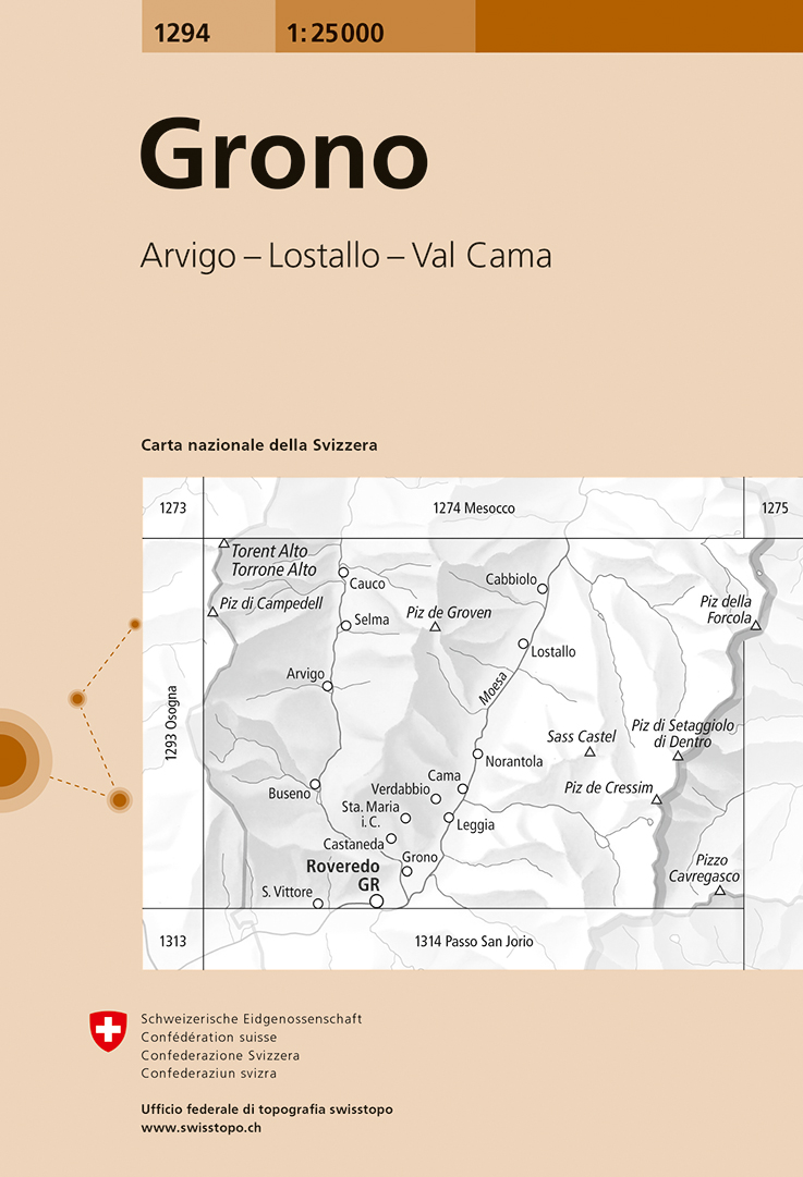
Zeer gedetailleerde wandelkaart van een deel van Zwitserland. De topografische details van deze kaarten zijn onovertroffen; de werkelijkheid is perfect weergegeven op deze kaart van uitzonderlijk hoog niveau. Ze zijn geschikt voor alle soorten gebruik: voor eenvoudige wandeltochten in simpel terrein tot zware bergtochten en beklimmingen van de grote toppen in de Alpen. Bedenk wel dat de kaart in uiterlijk beperkt blijft tot de topografische details: er is geen toeristische informatie ingetekend als camping of gemarkeerde paden. Wandelpaden staan er wel op in gestippelde zwarte lijnen, maar zijn ondergeschikt aan de topografie. Als kaart is het de meest gedetailleerde die er te vinden is en - zoals gezegd - van topkwaliteit. De kaarten worden gemiddeld om de 3 tot 4 jaar vernieuwd, maar er zijn ook oudere kaarten die gewoon nog de laatste editie zijn.

Voor de 'gewone' bergwandelaar zijn de Kompass-wandelkaarten die inmiddels bijna heel Zwitserland dekken wellicht nuttiger: schaal 1:50.000 met ingetekende wandelroutes en andere informatie.

Steden/dorpen/gebieden/bergen/dalen/rivieren/meren:

Grono,Buseno, Leggia, Cama, Castaneda, Verdabbio, Norantola, Arvigno, Selma, Cauco, Cabbiolo, Lostallo, Torent Alto / Torone Alto, Piz della Forcola, Piz di Setaggiolo di Dentro, Piz de Groven, Piz di Campedell, Piz de Cressim, Piz Cavregasca, Sass Castel, Valle Mesolcina, Val Calanca, Lagh de Cama

€ 18.99
Reisgids Harz | ADAC

De ADAC reisgids Harz is een degelijke en overzichtelijke reisgids. De gids heeft aandacht voor alle belangrijke bezienswaardigheden. De gids bevat uitgebreide achtergrondinformatie, heldere fotografie en overzichtelijke kaarten om de bezienswaardigheden maximaal te kunnen doorgronden in de beschikbare reistijd. Overzichtelijk ingedeeld met een uitgebreide index om bezienswaardigheden te kunnen opzoeken in een handomdraai. De gids bevat daarnaast ook nog wat praktische informatie die de reis tot een goede totaalbeleving kunnen maken. Inclusief een uitneembare losse kaart!

Das praktische ADAC Reise-Set Harz bietet übersichtliche Informationen zu allen Sehenswürdigkeiten, spannende Hintergründe zu Geschichte, Kunst und Kultur sowie umfangreiches Kartenmaterial in bester Qualität. Entdecken Sie mit den ADAC Top Tipps und Empfehlungen und dem ADAC Quickfinder, Ihrem ganz persönlichen Erlebnis-Wegweiser, sämtliche Highlights der Region. Oder folgen Sie der ADAC Traumstraße und lernen Sie den Harz von seiner malerischsten Seite kennen. Mit dem ADAC Reise-Set gelingt Ihr Urlaub garantiert, denn zahlreiche Servicekästen mit Mobil- und Spartipps, übersichtliche Hotelseiten und klare Icons erleichtern die Planung.


Das ADAC Reise-Set beinhaltet:


- ADAC Reiseführer plus: der bewährte ADAC Reiseführer, erweitert um einen ausführlichen Magazinteil zu Land und Leuten, Geschichte, Kunst und Kultur


- Maxi-Faltkarte: eine hochwertige Straßenkarte der Region mit Kurzbeschreibung aller Sehenswürdigkeiten sowie einer Detailkarte zur ADAC Traumstraße


- Hardcover-Hülle für den geschützten Transport von Faltkarte und Reiseführer

Das Rundum-sorglos-Paket für einen perfekten Urlaub - einzeln stark, im Team unschlagbar.


€ 17.50
Spel Dier & sporen | Kosmos Uitgevers

Wie herkent het spoor van een pauw? Of de pootafdruk van een panda? Bij dit kaartspel moeten de spelers de juiste sporen bij de dieren zien te vinden. Het spel bestaat uit 50 kaartjes met kleurrijke illustraties: op de ene helft de dieren, op de andere helft hun sporen. De beste spoorzoeker wint! Een vrolijk kaartspel voor het hele gezin (vanaf 4 jaar), om al spelend de pootafdrukken van dieren te leren (her)kennen. Maak het spel nog wat moeilijker door het als memory te spelen. Een leuk en leerzaam bordspel, voor de hele familie!


€ 479.95
Barglobe Vivalto ivory, ivoor - trolley barglobe | Zoffoli

- Binnenin is plaats voor maximaal 9 glazen en 2 tot 3 flessen

- Vintage kaart

- Noordelijk halfrond draait


De barglobes worden verzonden in een zeer stevige doos en stootvrij verpakt. Wel moet u zelf nog enkele handelingen verrichten: op een simpele manier moeten de delen nog in elkaar worden gezet, maar dat is slechts een kwestie van wat schroeven en bouten volgens de handleiding plaatsen.


Vintage trolley bar globe on antiqued finish stand and classic ivory map. With its wonderful illustrations of sea monsters, mermaids and mythological figures, Vivalto globe can carry 2 or 3 bottles and approximately 9 glasses. The upper serving tray will provide an excellent space to store bar accessories, decanters, glassware and your favorite bottles of wine and liquor while additional bottles can be placed on the unique lower base shelf.


In this vintage styled map, imagination comes to life… A fascinating journey begins, one that combines the charm for maps, mythological illustrations and ancient symbolism. The planispheres realised with our Vintage Map will accompany you in this wonderful journey to the discovery of unexplored territories, with ancient sea routes, wind roses, sea monsters and mermaids. Reality and fantasy come together to create an horizon full of suggestions. A journey between space and time reserved for modern Argonauts thirsting for adventures.


Bar accessories not included.


Features


- Dimensions: 80 × 50 × h 95 cm


- Sphere diameter: 42 cm, the inner compartment can accommodate up to 9 glasses and 2/3 bottles. Additional bottles can be stored in the lower compartment and in the side tray.


- Map: vintage


- Colour: Ivory


Our Suggestions


- Designed to give a touch of elegance to your living room

- Ideal to accompany an aperitif or an after dinner with friends or work colleagues

- Perfect for decorating rooms in a classic style but does not exclude more modern locations

- Suitable for those with large spaces (for greater enhancement of the product we suggest placing it in an environment of at least 100 x 70 cm)

- The "Vivalto" trolley bar globe is also perfect as a gift idea to amaze and not go unnoticed.


€ 829.95
Barglobe Artemide classic - trolley barglobe | Zoffoli

- Binnenin is plaats voor maximaal 12 glazen en 4 tot 5 flessen

- 16e-eeuwse kaart

- Draait volledig rond zijn meridiaan, zowel wanneer deze open als gesloten is


De barglobes worden verzonden in een zeer stevige doos en stootvrij verpakt. Wel moet u zelf nog enkele handelingen verrichten: op een simpele manier moeten de delen nog in elkaar worden gezet, maar dat is slechts een kwestie van wat schroeven en bouten volgens de handleiding plaatsen.


Artemide is a chestnut-stained wooden Bar Cabinet. It is perfect to greet your guests with a twist of elegance. A fifty-centimetre-width spherical drinks cabinet with bottle case and glassware storage make the central part of this trolley bar globe. The upper tray offers an excellent surface to store your bar accessories, jugs, glasses and your special wine and liquor bottles. A useful bottom wooden shelf painted with water-based colours is also part of this beautiful Trolley Bar Globe. The globe sphere, whose map is a faithful reproduction of a 16th Century cartography, fully rotates around its meridian either when it is open or closed.


Bar accessories not included. 


Features


- Dimensions: 92 x 68 x h 98 cm


- Sphere diameter: 50 cm, the inner compartment can accommodate up to 12 glasses and 4/5 bottles. Additional bottles can also be stored in the lower compartment and in the side tray.


- 16th century map


- Colour: classic


Our suggestions


- Designed to give a touch of elegance to your living room or office


- Ideal to accompany an aperitif or an after dinner with friends or work colleagues


- It decorates rooms in a classic style but does not exclude more modern locations.


- Suitable for those with large spaces (for greater enhancement of the product we suggest placing it in an area of at least 110 x 90 cm)


€ 29.95
Wandelkaart 3035 Topo 3000 Vestfoldbyene - Grenland | Nordeca

Een nieuwe serie van Nordeca. Een grote kaart op scheurvast papier. Het heldere kaartbeeld wat we van de andere series ook kennen is hier gebruikt wat de kaart goed leesbaar maakt. 


Topo 3000 is a detailed map covering an area of 64 x 47 km (over 3000 km2) Here you will find the hiking routes easily, over the mountains, through the forest and along the roads. Lodgings are emphasised to facilitate your planning.


Gebied:  Tønsberg, Nøtterøy, Sandefjord, Larvik, Tjøme, Stavern, Skien, Porsgrunn, Nevlunghavn, Helgeroa, Langesund


- Detaljert og lettlest

- Dekker over 3000km2

- Målestokk: 1:50 000

- Tåler vann og hard bruk

- Tydelige avmerkede turstier

- Hytter og overnatting

€ 29.95
Wandelkaart 3026 Topo 3000 Lyngenhalvoya | Nordeca

Een nieuwe serie van Nordeca. Een grote kaart op scheurvast papier. Het heldere kaartbeeld wat we van de andere series ook kennen is hier gebruikt wat de kaart goed leesbaar maakt. 


Topo 3000 is a detailed map covering an area of 64 x 47 km (over 3000 km2) Here you will find the hiking routes easily, over the mountains, through the forest and along the roads. Lodgings are emphasised to facilitate your planning.


Gebied:  Lyngfjellan, Lyngstuva, Lyngseidet, Blåisvatnet, Lyngsdalen


- Detaljert og lettlest

- Dekker over 3000km2

- Målestokk: 1:50 000

- Tåler vann og hard bruk

- Tydelige avmerkede turstier

- Hytter og overnatting

€ 59.00
Fotoboek America's National Historic Trails | Rizzoli International

An inspirational bucket list for hikers, history buffs, armchair travelers, and all those who wish to walk in the hallowed footsteps of American history.

From the battlefields of the American Revolution to the trails blazed by the pioneers, lands explored by Lewis and Clark and covered by the Pony Express, to the civil-rights marches of Selma and Montgomery, this is the official book of the country's 19 National Historic Trails. These trails range from 54 miles to more than 5,000 and feature historic and interpretive sites to be explored on foot and sometimes by paddle, sail, bicycle, horse, or by car on backcountry roads. Totaling 37,000 miles through 41 states, our entire national experience comes to life on these trails--from Native American history to the settlement of the colonies, westward expansion, and civil rights--and they are beautifully depicted in this large-format volume.

ART ONE: SPANISH SOUTHWEST

El Camino Real de Tierra Adentro Trail

El Camino Real de los Tejas Trail

Juan Bautista de Anza Trail

Old Spanish Trail


PART TWO: EAST COAST

Captain John Smith Chesapeake Trail

Overmountain Victory Trail

Washington-Rochambeau Revolutionary Route Trail

Star-Spangled Banner Trail


PART THREE: WESTWARD EXPANSION

Lewis and Clark Trail

Santa Fe Trail

Oregon Trail

Mormon Pioneer Trail

California Trail

Pony Express Trail

Iditarod Trail


PART FOUR: AMERICAN DIVERSITY

Ala Kahakai Trail

Trail of Tears Trail

Nez Perce (Nee-Me-Poo) Trail

Selma to Montgomery Trail


€ 89.95
Fotoboek My Himalaya | teNeues

The life's work of photographer Olivier Follmi and an homage to the incomparable landscape, people, and spirituality of the Himalayan region. The work of Olivier Follmi exudes authenticity and spirituality. For more than 40 years, the prize-winning photographer has documented the landscape and peoples of the Himalayas, a region he first got to know on a hiking trip in the 1980s. Captivated by Tibetan culture, people, and their harmonious coexistence with nature, Follmi returned to the mountain region on numerous occasions - at times as a mountain guide, at others to live and learn from spiritual leaders in a Buddhist temple. The Himalayas became his destiny, and he became one of the most sensitive and insightful observers of life in Tibet. This rich photo book of the Himalayas is at once a remarkable retrospective and an homage to the Tibetan culture and spirituality which has so defined and characterised Follmi's life and work. Page after page reveals photographs of extraordinary emotion, colour, tradition, and beauty, alongside inspiring anecdotes and stories from the photographer. My Himalaya is an enriching and enlightening book for anyone looking toward a more mindful way of life, as well as for all those interested in photography, trekking, landscape, and Buddhism. AUTHOR: With his roots in France, Switzerland, and Italy, photographer Olivier Follmi spent more than 20 years travelling and photographing the most remote areas of the Himalayas, before he then spent the next 20 years travelling every continent on Earth. SELLING POINTS: * Olivier Follmi's most powerful and emotional photographs from 40 years of Himalayan travels * A visually stunning tribute to the Himalayan mountains and people from one of the most sensitive observers of Tibetan culture * Follmi has several best-selling books to his name, as well as numerous international prizes for his photography and his humanitarian work 200 colour and b/w images

€ 17.50
Wandelgids Leichte Wanderungen Münchner Berge | Rother Bergverlag

De ‘Rother Wanderbücher’ behandelen telkens de 50 mooiste wandelingen, die variëren van eenvoudige kindvriendelijke wandelingen tot routes die aanzienlijk meer ervaring vereisen. Uitvoerige routebeschrijvingen, een aantrekkelijke lay-out met vele kleurenfoto’s, niets aan duidelijkheid te wensen gelaten hoogteprofielen, kaartjes met de ingetekende route en enige achtergrondinformatie. Het verschil met de rode wandelgidsjes van Rother is dat ze een groter gebied bestrijken: handig voor de één, minder bruikbaar voor de ander.

144 Seiten mit 85 Farbabbildungen

40 Wanderkärtchen im Maßstab 1:25.000 und 1:50.000, 40 Höhenprofile, eine Übersichtskarte

Wer gerne kurze, flache Strecken wandert, kommt mit den »Leichten Wanderungen – Genusstouren Münchner Berge« auf seine Kosten. Dieses Rother Wanderbuch stellt 40 Touren zu besonders schönen Zielen in den bayerischen und Tiroler Bergen sowie im Alpenvorland vor. Sie führen mit wenig Steigung auf aussichtsreichen Wegen durch wunderschöne Natur. Im alpinen Gelände warten Panoramawege und Gipfel mit beeindruckender Fernsicht, auf den Talwanderungen idyllische Fluss- und Seenlandschaften mit Aussichtsplätzen zum Innehalten und Genießen. Und auf allen Wanderungen laden gemütliche Almen und Gasthäuser zur Einkehr ein.

Die einfachen Touren eignen sich besonders für Genusswanderer, Langschläfer, Familien mit Kindern, Senioren und alle, die es beim Wandern geruhsam angehen lassen möchten. Die Länge variiert von einer bis vier Stunden Gehzeit. Alle Wanderungen folgen gut ausgeschilderten Wegen und werden mit Fotos, Kartenausschnitten mit eingezeichnetem Routenverlauf sowie aussagekräftigen Höhenprofilen detailliert beschrieben. Zu allen Touren stehen GPS-Tracks kostenlos zum Download bereit. Die meisten Ziele sind mit öffentlichen Verkehrsmitteln erreichbar und fast jede Tourenbeschreibung wird durch eine Anekdote, Sage oder historische Begebenheit ergänzt. Die Umschlagklappe präsentiert alle 40 Touren mit Gehzeiten, Höhenangaben und Besonderheiten im Überblick, sodass die passende Tour einfach und schnell ausgewählt werden kann.

Abonneer op