€ 18.50
Wandelgids Lofoten und Vesterålen | Rother Bergverlag

De Rother wandelgidsen beschrijven zeer goed de wandelingen in specifieke gebieden. In de gids vindt men kaarten, routebeschrijvingen en de nodige praktische informatie om van de wandelingen/trekkings een geslaagde onderneming te maken. De zwaarte van de wandelingen staat aangegeven in rood - blauw of zwart!

228 Seiten mit 142 Farbabbildungen, 50 Höhenprofile, 50 Wanderkärtchen im Maßstab, 1:25.000/1:50.000/1:75.000, zwei Übersichtskarten, GPS-Tracks zum Download


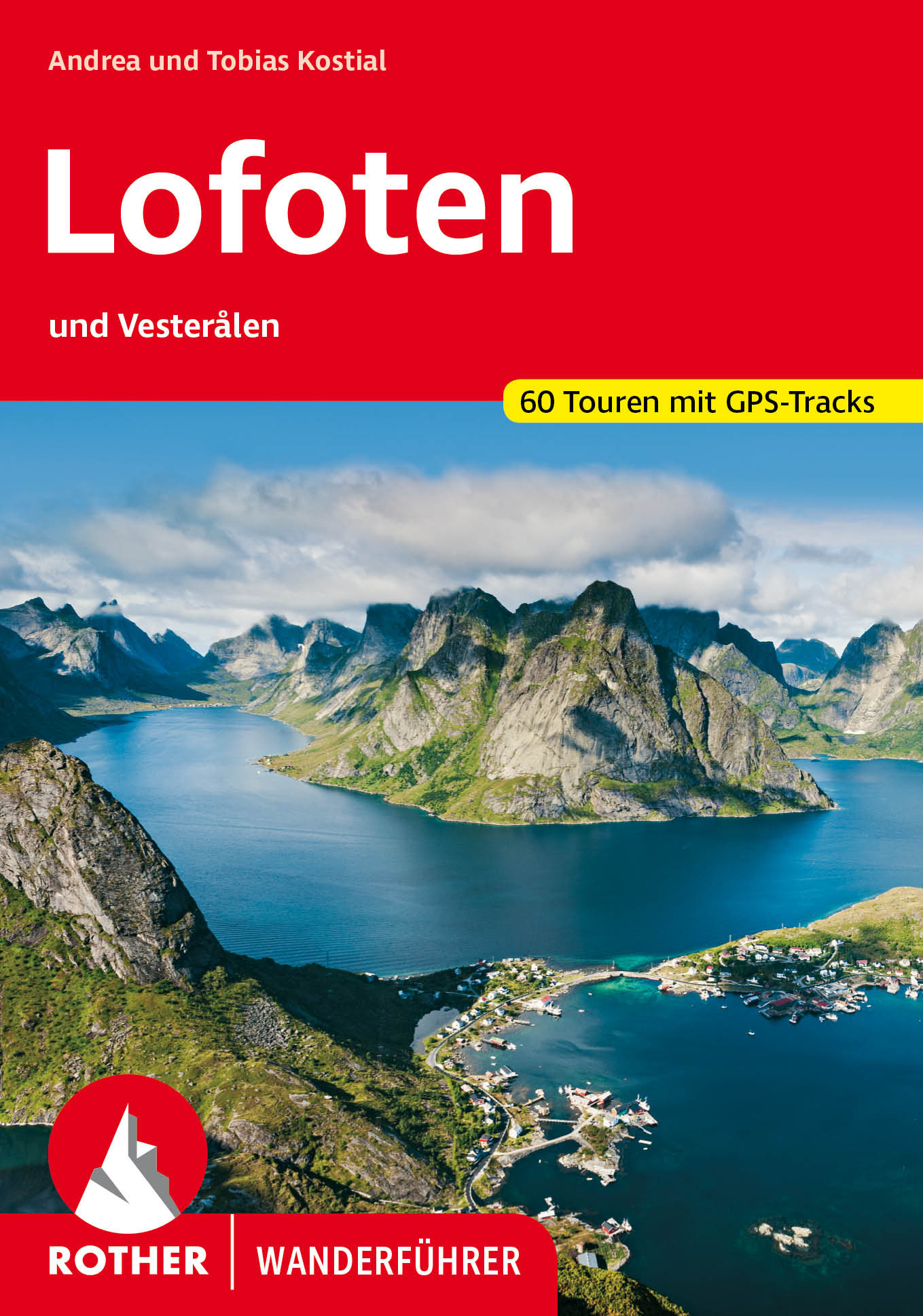
Karibisch anmutende Sandstrände, bizarre Gebirgslandschaften mit hochalpinem Flair, bunte Fischerhütten, eingetaucht ins romantische Licht der Mitternachtssonne: Schon der deutsche Kaiser Wilhelm II. schätzte dieses zauberhafte Ambiente. Auf seinen Spuren wandelt man auf dem nach ihm benannten »Keiservarden«, einem kleinen Gipfel mit fantastischem Panorama und eines von unzähligen lohnenden Wanderzielen auf den Inseln nördlich des Polarkreises. 50 besonders spannende Touren präsentiert der neue Rother Wanderführer Lofoten und Vesterålen.


Das Tourenangebot erstreckt sich von familientauglichen Küstenspaziergängen zwischen malerischen Dörfern bis hin zu anspruchsvollen Bergbesteigungen für Nervenstarke – Kraxeleinlagen und schwindelerregende Tiefblicke von den schmalen Graten inklusive. Sensationelle Ausblicke bieten sich aber auch von den gemütlicheren Wegen, das tiefblaue Nordmeer und die steil aufragenden Berge bilden für fast alle Wanderungen die perfekte Kulisse.


Die Autoren Andrea und Tobias Kostial sind seit vielen Jahren mit ihren Kindern oder als Reiseleiter auf den Lofoten und Vesterålen unterwegs. Ihre Erfahrungen fließen in den Wanderführer ebenso positiv ein wie ihre Begeisterung für die Inseln. Das Buch liefert alle wichtigen Infos zur Infrastruktur jeder Wanderung, dazu präzise Wegbeschreibungen, Kartenausschnitte mit eingezeichnetem Routenverlauf und aussagekräftige Höhenprofile sowie GPS-Tracks zum gratis Downloaden von der Internetseite des Bergverlag Rother. Zahlreiche Tipps zu Sehenswertem am Wegesrand sowie die spektakulären Fotos machen schon die Vorbereitung der (Wander-)Reise in den hohen Norden zum Vergnügen.


€ 19.50
Wandelgids Walking on the Gower | Cicerone

Wandelgids met 30 wandelroutes in het zuiden van Wales

This guidebook presents 30 circular day walks across the Gower Area of Outstanding Natural Beauty, taking in the rich variety of landscapes across this beautiful area of South Wales. Ranging from 2½ to 14 miles long, there are walks to suit all abilities. The peninsula is famous for its spectacularly steep, rugged coastline and golden sandy beaches but this guide also takes walkers to the inland valleys, hills and ridges little explored by most holidaymakers.


Routes are illustrated with OS mapping extracts and inspiring photography and accompanied by a route summary table to help you choose walks to suit your location and ability. Along the way, the author provides a wealth of information on plants, animals, geology, history and archaeology of a region. There is something for everyone, all within a compact area easily accessible from Swansea and Mumbles.


Coastal areas such as those around Langland, Oxwich and Port Eynon are well frequented, but this guidebook concentrates on places where walkers can escape the crowds to find peace and solitude in this exceptionally beautiful and unspoilt countryside.


Seasons

wild winter storms promise dramatic seascapes; in springtime cliffs and valleys are carpeted in flowers; summer months allow a refreshing dip along a coastal walk


Centres

Mumbles is the largest village at the eastern end of Gower


Difficulty

only short ascents but some of the footpaths are uneven in places; a variety of routes with differing lengths to suit every ability


Must See

Gower is an exceptional area for coastal landscapes, wildlife and geology; scenic unspoilt beaches combine with a rich cultural history

€ 24.95
Wegenatlas The Wild Atlantic Way Ierland | Xploreit Maps

Yvonne Gordon provides an essential guide to Ireland's epic coastal driving route - the Wild Atlantic Way. In this newly revised and updated edition she divides the route into 16 easy-to-follow scenic drives from Kinsale, in south Cork, all the way to the little village of Muff in the far north of the island. Each drive can be comfortably completed in one day and includes an overview map with photographs to illustrate the text. Information is provided on mileage, directions, official discovery points and numerous additional attractions, including the many towns and villages dotted along the way. The generous fold-out maps can be used to follow the guided route or to design custom itineraries. 31 handy fold-out maps. 16 easy-to-follow drives. Official Discovery Points highlighted. Additional recommendations and tips. Route planning maps for the national road network. Distance charts for towns and villages. Yvonne Gordon is an award-winning travel writer who writes about Ireland for publications around the globe including the Irish Independent, The Guardian, Lonely Planet, The Washington Post, National Geographic Travel, BBC Travel and Hemispheres magazine. She is the author of Frommer’s Ireland, co-author of Back Roads Ireland and Lonely Planet Experience Ireland and her awards include Irish Travel Writer of the Year. Based in Dublin, she explores the Wild Atlantic Way regularly, finding something new and fascinating on each journey.

€ 51.50
Fotoboek Map | Phaidon

300 stunning maps from all periods and from all around the world, exploring and revealing what maps tell us about history and ourselves.

Map: Exploring the World brings together more than 300 fascinating maps from the birth of cartography to cutting-edge digital maps of the twenty-fist century. The book's unique arrangement, with the maps organized in complimentary or contrasting pairs, reveals how the history of our attempts to make flat representations of the world has been full of beauty, ingenuity and innovation.

Selected by an international panel of curators, academics and collectors, the maps reflect the many reasons people make maps, such as to find their way, to assert ownership, to record human activity, to establish control, to encourage settlement, to plan military campaigns or to show political power. The selection includes the greatest names in cartography, such as James Cook, Gerard Mercator, Matthew Fontaine Maury and Phyllis Pearsall, as well as maps from indigenous cultures around the world, rarely seen maps from lesser'known cartographers, and maps of outstanding beauty and surprising individuality from the current generation of map makers.

€ 15.50
Reisgids CityTrip Tel Aviv | Reise Know-How Verlag

Reise Know-How is een Duitstalige praktische reisgids voor alle leeftijden, boordevol informatie over accommodatie van budget tot luxe, vervoer en plaatsbeschrijvingen. Kenmerk: brede cultuur en achtergrondinformatie, bondig geschreven.

Tel Aviv gilt als die Partyhochburg des Nahen Ostens. Das Nachtleben ist legendär, aber auch die vielen anderen Facetten der quirligen Stadt lohnen eine Entdeckung: Neben reizvollen Stränden, erstklassigen Boutiquen und kultigen Galerien locken außergewöhnliche Restaurants, Cafés und Bars Gäste aus aller Welt hierher – und nicht zuletzt das historische Jaffa, das über einen der ältesten Häfen der Welt verfügt.


Dieser aktuelle Stadtführer ist der ideale Begleiter, um alle Seiten der israelischen Metropole selbstständig zu entdecken:

Die wichtigsten Sehenswürdigkeiten und Museen der Stadt sowie weniger bekannte Attraktionen und Viertel ausführlich vorgestellt und bewertet

Faszinierende Architektur zwischen Bauhaus-Gebäuden und der historischen Bausubstanz Jaffas

Abwechslungsreiche Stadtspaziergänge

Erlebnisvorschläge für ein langes Wochenende

Ausflüge nach Ramat Aviv und Jaffa

Shoppingtipps vom traditionellen Markt bis zu den originellsten Souvenirs

Die besten Lokale der Stadt und allerlei Wissenswertes über die israelische Küche

Tipps für die Abend- und Nachtgestaltung: vom Theaterbesuch bis zu den angesagtesten Klubs

Das Viertel der Jemeniten

Tel Aviv zum Träumen und Entspannen: Yarkon Park, Gan HaPisgah, Gan Ha’atzmaut

Ausgewählte Unterkünfte von preiswert bis ausgefallen

Alle praktischen Infos zu Anreise, Preisen, Stadtverkehr, Touren, Events, Hilfe im Notfall ...

Hintergrundartikel mit Tiefgang: Geschichte, Mentalität der Bewohner, Leben in der Stadt ...

Kleine Sprachhilfe Hebräisch mit den wichtigsten Vokabeln für den Reisealltag

Faltplan zum Herausnehmen


€ 23.99
Kookboek Caravanity camping kookboek | Kosmos Uitgevers

Na het succes van Caravanity heeft Femke Creemers het Caravanity Camping Kookboek geschreven. De echte culi’s en foodies komen er wel uit, maar de meesten van ons vinden het nog altijd lastig om een smakelijke, maar niet al te ingewikkelde maaltijd te bereiden op een of twee pitjes bij de tent of caravan. Femke Creemers verzamelde de beste recepten, geeft tips voor de handigste keukenattributen en ontneemt je ieder excuus om ’s avonds iets te halen bij de plaatselijke snackbar. Het Caravanity Camping Kookboek biedt volop inspiratie om van iedere campingmaaltijd een feestje te maken!

€ 14.95
Magnetische puzzel City Puzzle Magnets Roma - Rome | Extragoods

Een magnetische puzzel van 100 stukjes van de plattegrond van Rome.

De puzzel wordt gepresenteerd in een tinnen doos met een aantrekkelijk design bestaande uit een deel van de plattegrond van de stad

Je leert een stad kennen op een speelse wijze

Een hedendaagse cartografie

Afmetingen van de puzzel: 33 x 23 cm

Afmetingen van de doos: hoogte 9 cm; diameter 7 cm


€ 14.95
Magnetische puzzel City Puzzle Magnets Firenze - Florence | Extragoods

Een magnetische puzzel van 100 stukjes van de plattegrond van Florence.

De puzzel wordt gepresenteerd in een tinnen doos met een aantrekkelijk design bestaande uit een deel van de plattegrond van de stad

Je leert een stad kennen op een speelse wijze

Een hedendaagse cartografie

Afmetingen van de puzzel: 33 x 23 cm

Afmetingen van de doos: hoogte 9 cm; diameter 7 cm


€ 14.95
Magnetische puzzel City Puzzle Magnets Barcelona | Extragoods

Een magnetische puzzel van 100 stukjes van de plattegrond van Barcelona.

De puzzel wordt gepresenteerd in een tinnen doos met een aantrekkelijk design bestaande uit een deel van de plattegrond van de stad

Je leert een stad kennen op een speelse wijze

Een hedendaagse cartografie

Afmetingen van de puzzel: 33 x 23 cm

Afmetingen van de doos: hoogte 9 cm; diameter 7 cm


€ 15.50
Reisverhaal Chasing The Phantom | Eduard Fischer

Eduard Fischer takes us on an exploration of myth, art, science, and the sacred space of high mountains. This is an account of adventure and deep reflection accompanied by a selection of the author's stunning colour photographs. After first visiting the Trans-Himalayan region of Ladakh in 1985, he returned again and again, seeking to catch a glimpse of the phantom of the Himalayas - the elusive snow leopard.


During these visits he became enthralled with the unique culture of this ancient mountain kingdom, one of the oldest enclaves of Buddhism. The phantom cat itself becomes, at turns, Eduard's quarry, nemesis, obsession, and finally, in a surprising twist of destiny, his teacher.

Abonneer op