€ 18.95
Kinderpuzzel GeoPuzzle Africa and the Middle East - Afrika en het Midden Oosten | GEOtoys

Unieke, educatieve puzzel van Afrika en het Midden Oosten met 65 puzzelstukjes in landvormen. 

Gemaakt van gerecycled materiaal en ontwikkeld voor kinderen vanaf 4 jaar.


GeoPuzzles are maps of the major continents, with pieces shaped like individual countries. By putting together a GeoPuzzle, children learn what countries look like, what their names are, and where they are in relation to one another. At 50-70 pieces, the puzzles are perfect for ages 4-12. Designed by an art professor, GeoPuzzles are generously sized, brightly colored, and each piece is large enough to be easily handled.


GeoPuzzle Africa has 65 pieces, and is a jumbo-sized 17 x 17 inches.

€ 15.50
Fietsgids Bikeline Fluss-Radwege Schwäbische Alb | Esterbauer

Praktische fietsgids met detailkaarten, ingetekende route, informatie over overnachten en fietsenmakers, zwaarte en hoogteprofiel. In spiraalbinding, Duitstalig

Albtäler-Radweg, Neckartal-Radweg, Lauter-Alb-Lindach-Radweg, Filstalroute, Brenz-Radweg, Lonetal-Radweg, Donau-Radweg und Lautertal-Radweg

Die Schwäbische Alb mit ihren Wäldern, Wiesen, sanften Bergen, vielen Höhlen und steilen Felsen, mit den Burgen, Schlössern, Klöstern, uralten Dörfern und

Fachwerkstädtchen gilt als Paradies für Radfahrer. Es gibt ein sehr gut ausgebautes und beschildertes Radwegenetz, in vielen Orten werden Leihräder angeboten.

Die in diesem Buch vorgestellten Touren verlaufen überwiegend in Flusstälern und ermöglichen zum Teil ein Radeln ohne große Steigungen. Doch ganz steigungsfrei

ist keine der Touren. Wer die hügeligen oder auch steigungsreichen Abschnitte scheut, dem ist die Benutzung eines E-Bikes zu empfehlen. Der als Qualitätsroute mit

vier Sternen ausgezeichnete Albtäler-Radweg bietet sich ganz besonders als E-Bike-Tour an, denn entlang des Weges gibt es viele E-Bike-Verleih- und Ladestationen.

Die Touren in diesem Buch lassen sich vielfältig variieren. So können Sie Teilabschnitte von längeren Radwegen als Tagesauflug planen oder zwei oder mehrere Radrouten

ganz oder abschnittsweise kombinieren, um einen ganzen Radurlaub in der Region zu genießen


Die Gesamtlänge aller 8 Touren beträgt rund 808 Kilometer. Die längsten Touren sind der gut 210 Kilometer lange Abschnitt auf dem Donau-Radweg und der Albtäler-Radweg mit rund

187 Kilometern. Die kürzeste Tour ist der ca. 43 Kilometer lange der Lonetal-Radweg.


€ 12.95
Reisgids Pocket Abu Dhabi | Lonely Planet

Pocket reisgidsen van Lonely Planet zijn een kleinere versie dan de 'echte' Planets. Vaak echter van bijzondere bestemmingen binnen een bepaald land waardoor er meer aandacht is en uitgebreidere tips zijn voor die bepaalde streek i.v.m. de grote Planets. Handzaam formaat, makkelijk in de binnenzak! Toch ook deze vol met praktische informatie.

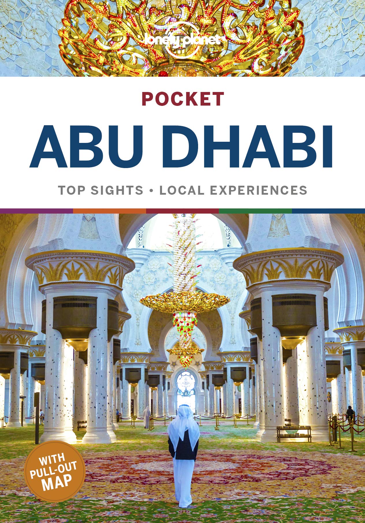
Lonely Planet’s Pocket Abu Dhabi is your passport to the most relevant, up-to-date advice on what to see and skip, and what hidden discoveries await you. Explore one of Arabia’s most magnificent mosques, the Sheikh Zayed Grand Mosque, ride the world’s fastest rollercoaster, and stroll along the Corniche and laze on its beautiful public beaches – all with your trusted travel companion. Get to the heart of Abu Dhabi and begin your journey now!


Inside Lonely Planet’s Pocket Abu Dhabi:


Full-colour maps and images throughout

Highlights and itineraries help you tailor your trip to your personal needs and interests

Insider tips to save time and money and get around like a local, avoiding crowds and trouble spots

Essential info at your fingertips - hours of operation, phone numbers, websites, transit tips, prices

Honest reviews for all budgets - eating, sleeping, sightseeing, going out, shopping, hidden gems that most guidebooks miss

User-friendly layout with helpful icons, and organised by neighbourhood to help you pick the best spots to spend your time

Covers Al Markaziyah, Tourist Club Area, Al Khadiya, Breakwater, Yas Island and more

The Perfect Choice: Lonely Planet’s Pocket Abu Dhabi is our colourful, easy to use and handy guide that literally fits in your pocket, providing on-the-go assistance for those seeking the best sights and experiences on a short visit or weekend away.


€ 15.95
Wegenkaart - landkaart Kgalagadi Transfrontier Park | Infomap

Kgalagadi Transfrontier Park in Zuid Afrika, wegenkaart 1:500.000. Met toeristische informatie en geschikt voor gebruik met GPS


The reverse side of the map shows the main tourist areas in the large scale of 1: 270 000.


The traveller can make use of the well established and well maintained infrastructure and roads on the South African side of the Park including rest camps that offer all luxuries or rough it on the Botswana side with deep sandy tracks and unfenced camping spots. Apart from the park itself our map covers also the immediate surrounding of the park with emphasis on the area north of the park in Western Botswana between Hukuntsi and Ukhwi known as the Western Woodlands, a remote and wild paradise for the 4x4 enthusiast.Easy to read in a vehicle


Practical, user-friendly scale

Accommodation listed with booking details

Waterholes

Distances between points through the park

Viewpoints and picnic sites

GPS co-ordinates

Botswana section with camps listed

Gate times

Border post information

€ 32.95
Wereldkaart Politiek, 92 x 61 cm | National Geographic

Politieke wereldkaart van National Geographic. De klassieke blauwe vorm, met helder kaartbeeld. De landen hebben met kleuren duidelijke grenzen en er staan opvallend veel topografische details op. Ondanks de schaal een behoorlijk aantal plaatsnamen. Mooi vormgegeven met een klassieke rand er om heen.


This world map features the Winkel Tripel projection to reduce distortion of land masses as they near the poles. Features include subtle border coloring on land, and prevailing winds and ocean currents at sea. Separate insets show the North and South Polar Regions, world vegetation and land use, and world population density.

€ 16.95
Stadsplattegrond Streetmap Cape Town - Kaapstad | MapStudio

Uitgebreide stadsplattegrond van Kaapstad en directe omgeving. 


The Cape Town & Peninsula Street Map is the ideal travel companion to find your way around Cape Town.


Coverage includes:


North : Milnerton

West : Hout Bay

East : Jakes Gerwel (Vanguard Drive)

South : Muizenberg


Great content which includes a detailed map of Cape Town CBD and Waterfront insert map.


The main map is in detailed 1: 25 000 street level scale, which depicts parks and reserves, golf courses, sports fields and stadiums, intersections, route numbers and interchange names. The map also includes places of interest, historical sites and hotels, suburb names and boundaries, schools and sporting venues, industrial areas, wine estates and heritage sites as well as bird sanctuaries and post offices and libaries.


€ 20.95
Reisgids City Guide Hong Kong | Insight Guides

Dé gids als het gaat om achtergrondinformatie en prachtige foto’s. De Insight Guide is niet alleen een reisgids het is tevens een leuk boek om in weg te dromen en is ook voor thuisblijvers interessante lectuur, geschreven door een team van auteurs, van wie de meesten zelf woonachtig zijn in het land waarover de gids handelt. Uitvoerige geschiedschrijving en hedendaagse journalistiek, geillustreerd met sublieme foto's, informatie over vervoer, accommodatie, restaurants, reisbenodigdheden, toeristische tips, uitgaan, sport, nuttige adressen en talloze andere wetenswaardigheden. De Insight Guide stedengids is hierdoor niet alleen een bron van informatie en inspiratie, maar ook een bijzonder praktische reisgids.. Kwalitatief van een hoog niveau! Engels.

With its fabled urban landscape and vibrant Chinese culture, Hong Kong is one of the world’s most exciting cities. Whether you want to take a bay cruise on the Star Ferry, eat and shop your way around Kowloon, or find peace at an atmospheric temple, Insight City Guide Hong Kong will make sure you have the quintessential Hong Kong experience. Features by local writers delve into topics including the city’s dim sum tradition, Chinese medicine, and the local love of horse racing, while evocative accounts of Hong Kong’s districts bring the city to life, from the dramatic vistas of the Peak to the shops and bars of lively Wan Chai and Causeway Bay, and the beaches and monasteries of the outlying territories and islands. Full-color photography and maps help you navigate with ease and our detailed Travel Tips gives you all the practical information you need to plan your trip, including our selection of the best and most authentic hotel and restaurants.

€ 39.95
Boekenpoef - Tabletpoef Beige | The Book Seat

Ga jij ook graag helemaal down under in een spannend boek? Kun je uren voor je iPad zitten? Dan is The Book Seat iets voor jou! Met zo’n unieke boekenpoef, uitgevonden in Australië, lees of surf je zolang je wilt zonder pijnlijke nek of arm. Eender waar of hoe. Helemaal handenvrij!


Of je nu ligt, zit of staat, ... The Book Seat past zich aan jou aan. Zet hem gewoon in de positie die jij het comfortabelst vindt. Grote en kleine boeken, je iPad, ... The Book Seat houdt alles op zijn plaats. Je kunt hem zelfs als reiskussentje gebruiken, én hij heeft een handig zakje voor je bril, pen of gsm.


The Book Seat is een boekenpoef gemaakt uit kwaliteitsmateriaal en opgevuld met bonen. Voor de hoes heb je de keuze uit 9 modieuze kleuren. Kies jouw kleur en lees in stijl!

Abonneer op