€ 6.99
Spel Wildlife weetjes Kwartet | Identity Games

Wildlife Weetjeskwartet is het leukste kaartspel voor kinderen met prachtige foto's en leuke weetjes over de vele bijzondere dieren in Afrika. Hoe zwaar is een nijlpaard? Hoe oud kan een olifant worden? 

Vanaf 6 jaar

2-4 spelers

Speelduur ongeveer 20 minuten

€ 22.50
Wandelgids Bruxelles - Liege - Hannut - Huy | GR Sentiers

De GR 579 start bij de wandelboom achter de Sint Michielskathedraal in Brussel; op die plaats komen ook de GR 12 en de GR 126 voorbij.  Van Brussel  gaat het door het Terkamerenbos en Watermael-Bosvoorde naar het Zoniënwoud.  Als je dat verlaat kruis je in Huldenberg  de GR 512 om door een glooiend landschap naar Pécrot op Waals grondgebied te stappen.  Doorheen het mooie Waals-Brabant trek je naar Jodigne en dan door Waals Haspengouw naar Orp-le-Petit enAvernas-le-Bauduin, waar je de GR 564 ontmoet, die uit de Kempen komt en de weg wijst via Hannut naar Hoei.  Als je de GR 579 verder volgt kom je langs kasteelhoeven en kastelen zoals Jehay-Bodegnée en Warfusée.  Boven de Maasvallei trek je naar Luik terwijl je de Terrilroute (de GR 412) nog kruist

€ 37.95
Wereldkaart World pacific-centred wall map, 136 x 100 cm | Maps International

View the world from a different perspective with Maps International's Pacific centred world wall map with flags. 


Map details: This Pacific centred wall map shows the world centred along the 150° line of longitude. Instead of parting the map along the Pacific Ocean (as most world wall maps are), this one parts the map along the Atlantic Ocean meaning Europe and the Americas are in separate sides of the map! 


Pacific centred world wall map has countries marked in different colours according to international country boundaries. Capital cities (including approximate population size) and hill shading are also shown. Mountain peaks and depths are given on this Pacific centred world wall map. Pacific centred map comes with a panel of country flags displayed on the base of the map. 


Map uses: Great for re-learning about world and its geography. Ideal for use in secondary school classrooms and who those wishing to challenge their thinking.


Afwerking: geplastificeerd

De wandkaart wordt afgewerkt met een inkapselingsproces. Inkapseling betekent dat de kaarten met warmte worden geperst tussen twee vellen film van industriële kwaliteit. Houd er rekening mee dat de randen van deze kaart niet zijn geplastificeerd.


Inkapseling geeft de kaart een schrijf- / veegafwerking, wat betekent dat met een droog afveegbare marker elk schrift op de kaart kan worden weggeveegd.


€ 15.95
Wegenkaart - landkaart Australia - Australië | Hema Maps

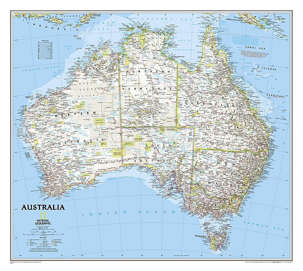
Mooie, grote, duidelijke kaart van Australië met veel informatie. Oa bezinestations (ook in de outback) en een goed overzicht van de doorgaande (grote) wegen waardoor de kaart erg handig is van het plannen van uw route. Ook staan er afstanden op vermeld.


Verder staan er stadkaartjes op van het (centrum) van de belangrijkste Australische steden:


Adelaide, Brisbane, Canberra, Darwin, Hobart, Melbourne, Perth en Sydney


Hema’s iconic large map of Australia is ideal as a trip planning tool and travel companion. Marked on the map are localities, the major road network, distances and major national parks. The map also shows localities, the major road network, distances and major national parks. The visual appeal makes it perfect as a decorative map or an educational tool. On the reverse side is an overview of Australia's iconic touring regions featuring history, geology and landforms, nature, bucket-list attractions and iconic 4WD tracks.


Key Features

Hema's iconic map of Australia

Overview of Australia's iconic touring regions

Outback fuel distances

National parks

Road distances

Aboriginal land

Distance grid

Index


€ 19.95
Kinderwereldkaart Dierenwereldkaart, 110 x 70 cm | Krüger & Schönhoff

Beleef de wonderlijke wereld van de dieren met deze informatieve, rijkelijk geïllustreerde Wereldkaart van de dieren!

Kennis vergaren is een fantastische beleving! Deze dierenwereldkaart van Krüger & Schönhoff, decoratief en met veel informatie, nodigt de kleine en de grote dierenliefhebber als het ware uit om de wereld van de fauna te bewonderen en beter te begrijpen! Deze kaart bevat een uitgebreide selectie van de kleinste tot de meest gevaarlijke dieren. Zij geeft verregaande informatie betreffende bedreigde diersoorten, verscheidenheid van de leefwereld van de verschillende dieren en interessante wetenswaardigheden. Zo biedt deze kaart een antwoord op de vele vragen van kinderen en van iedereen die geïnteresseerd is in de vele facetten van de natuur en het milieu. 

€ 22.95
Wandkaart USA Politiek | Michelin

An annually updated political map of the USA. Beautifully coloured and laminated, with statistical information including population, surface area, state capital. Highlights the flags of each state. This laminated map, suitable to use with marker pens, is presented on a scale 1/3,450,000 and measures 100 x 127 cm.


* Flags of each states

* State boundaries and each state highlighted in a different colour

* Statistical information: population, surface area, state capitals

* Fully laminated

* Keys in three languages: English, Spanish & French 


€ 34.95
Wandkaart Afghanistan & Pakistan, 55 x 83 cm | National Geographic

This is the latest and most detailed map of the region - a perfect complement for following today's news stories. Afghanistan's 34 administrative provinces and Pakistan's provinces and territorial boundaries are clearly delineated. The region's diverse terrain is expertly depicted in shaded relief and symbology, including the elevation of prominent mountains and ocean depths in meters. Superhighways, major roads, canals, railroads, oil infrastructure, and geologic features are detailed. This version is laminated—featuring a "write and wipe" surface and durable plastic covering.

Abonneer op