€ 20.95
Wandelgids The Lake District Fells Langdale | Cicerone

Uitstekende wandelgids voor dit uitdagende wandelgebied.

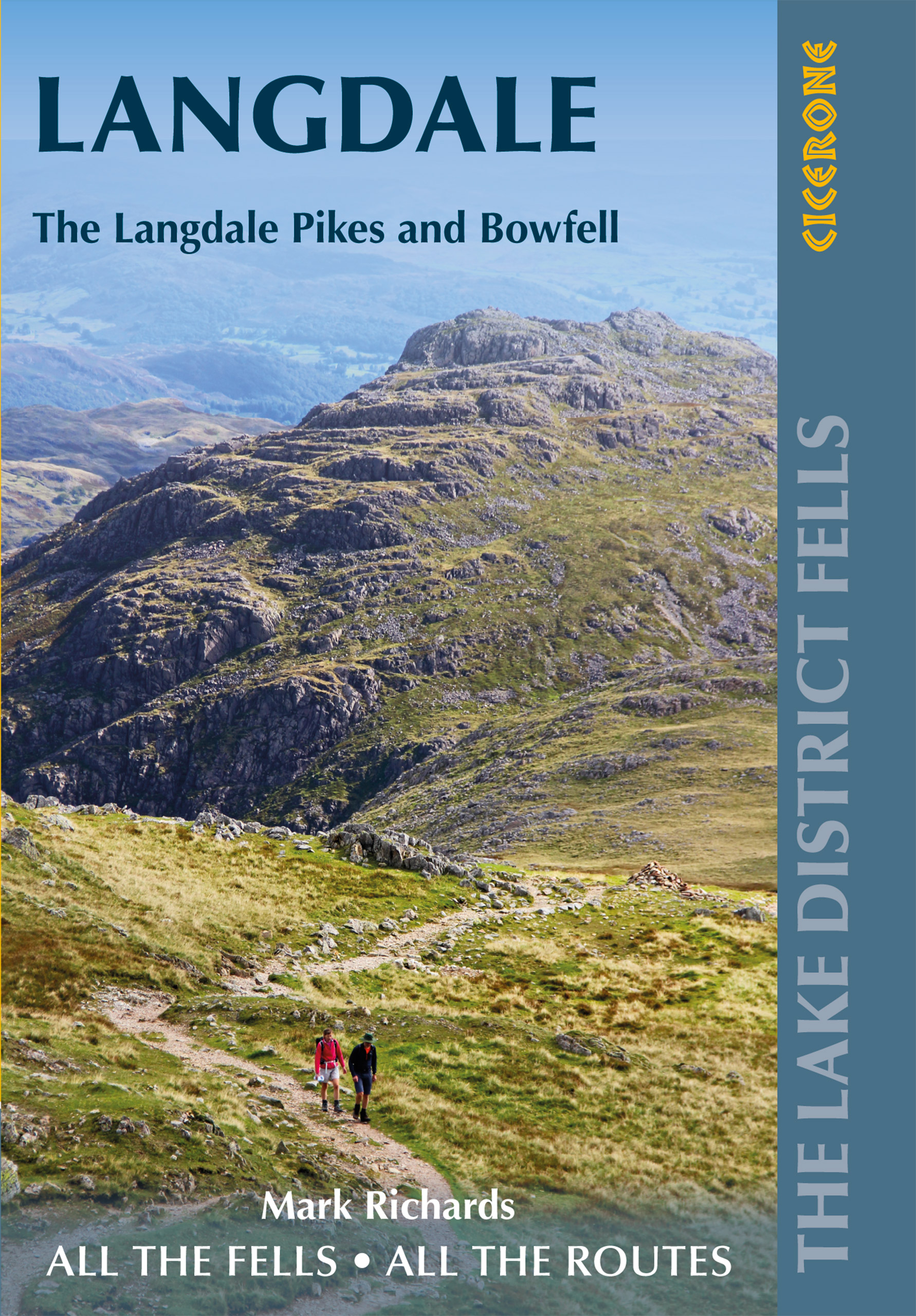
This guide describes ascents of 25 Lake District fells that can be climbed from Langdale and the Vale of Grasmere. Easily accessible from the popular bases of Grasmere and Ambleside, this area offers stunning scenery and fantastic walking, from the 'small but perfectly made' Loughrigg - ideal for a Sunday afternoon hike - to eye-catching Helm Crag ('the Lion and the Lamb'), from the lofty heights of Bowfell to the iconic Langdale Pikes. England's highest mountain, Scafell Pike, is also included in this volume.


Unlike other guidebooks which describe a single or limited number of routes to a particular destination, the aim of the Walking the Lake District Fells series is to offer all the options. These are presented as numbered sections which can be combined to create infinite possibilities - from simple ascents to longer ridge routes. You'll find the classics and popular routes alongside less traditional alternatives perfect for the wandering spirit. The series gives you both the freedom to devise your own routes and the information to make informed decisions, thanks to the clear descriptions of the routes, terrain, hazards, interesting features and safe descent paths should the weather close in. Also included are a handful of classic ridge routes for longer fell days.


Mark Richards' inimitable text is complemented by HARVEY mapping and the author's own beautiful sketch topos and panoramas. Perfect for keen hillwalkers and peak-baggers alike and ideal both for pre-planning and use on the hill, Walking the Lake District Fells is the new incarnation of the Fellranger series, which sees the volumes updated and trimmed to a more practical size. These true connoisseurs' guides are sure to inspire you to get out and explore the beautiful fells of Lakeland.

€ 20.95
Wandelgids The Lake District Fells Wasdale | Cicerone

Uitstekende wandelgids voor dit uitdagende wandelgebied.


This guide describes ascents of 25 Lake District fells that can be climbed from the valleys of Wasdale, Eskdale and Ennerdale. Quieter and wilder than the eastern side of the national park - though every bit as beautiful - this area is home to many of the region's most celebrated peaks, with highlights including iconic Great Gable, Pillar and Yewbarrow, as well as England's highest mountain, Scafell Pike.


Unlike other guidebooks which describe a single or limited number of routes to a particular destination, the aim of the Walking the Lake District Fells series is to offer all the options. These are presented as numbered sections which can be combined to create infinite possibilities - from simple ascents to longer ridge routes. You'll find the classics and popular routes alongside less traditional alternatives perfect for the wandering spirit. The series gives you both the freedom to devise your own routes and the information to make informed decisions, thanks to the clear descriptions of the routes, terrain, hazards, interesting features and safe descent paths should the weather close in. Also included are a handful of classic ridge routes for longer fell days.


Mark Richards' inimitable text is complemented by HARVEY mapping and the author's own beautiful sketch topos and panoramas. Perfect for keen hillwalkers and peak-baggers alike and ideal both for pre-planning and use on the hill, Walking the Lake District Fells is the new incarnation of the Fellranger series, which sees the volumes updated and trimmed to a more practical size. These true connoisseurs' guides are sure to inspire you to get out and explore the beautiful fells of Lakeland.

€ 15.95
Wegenkaart - landkaart Irak | Gizi Map

Een duidelijke en gedetailleerde algemene kaart met reliëf. Landschapskenmerken zoals meren, zoutmeren, zoutvlaktes, watergaten, moerassen en woestijnen worden onderscheiden en archeologische vindplaatsen worden gemarkeerd en in een tabel weergegeven.


€ 31.95
Wandelkaart Der Harz in 4 Teilen | Schmidt Buch Verlag

Kaartenset van 4 verschillende scheur- en watervaste kaarten van de Harz op een bijzonder gedetailleerde schaal van 1:30.000. Naast alle goede informatie die op een kaart hoort te staan staan er diverse wandelroutes op ingetekend met markeringen en nummers.  Ook MTB routes en aanbevelingen voor fietsroutes staan ingetekend.


Hoogtelijnen met 20 meter interval.


Vier Karten ergeben einen Harz.Den gesamten Harz im detaillierten Maßstab 1:30.000 haben wir auf vier wasserfesten und reißfesten Wanderkarten dargestellt - Für mehr Nutzungskomfort und Langlebigkeit.Nach dem bewährten Prinzip regionaler Anschlusskarten mit kleinen Überlappungsbereichen zeigen die Blattschnitte die Gebiete "Oberharz", "Mittlerer Harz", "Ostharz" sowie "Südharz" und beinhalten die beschilderten Wander- und Radwege sowie Streckenempfehlungen zum Radfahren und Mountainbiken.Das Karten-Set wurde mit dem BuchAward 2017 der ITB Berlin (weltgrößte Reisemesse) in der Kategorie Touristische Kartografie ausgezeichnet.Das ist neu mit dieser Auflage:- Aktualisierungen. Mit der aktuellen Auflage haben wir wieder Hinweise von Wanderern sowie vom Harzklub berücksichtigt und in eigener Recherche viele Gebiete aufwendig überprüft.Ausstattung:- Harzklub-Wanderwege mit Markierungen und Nummern- Thematische Fernwanderwege wie Harzer Hexen-Stieg, Selketal-Stieg, Harzer Grenzweg, Teufelsstieg, Karstwanderweg, Baudensteig, Försterstieg, Klosterwanderweg, Südharzer Dampflok-Steig- UTM-Gitter für GPS- Höhenlinien in 20-Meter-Schritten- dezente Gelände-Schummerung- beschilderte Fahrradwege- MTB- und Radweg-Empfehlungen- Stempelstellen der Harzer Wandernadel mit Nummern- Signaturen zu den Sehenswürdigkeiten, Camping- bzw. Wohnmobilstellplätzen und Jugendherbergen sowie zu Freizeitstätten wie Schwimmhallen, Freibäder, Golf- und Tennisplätze, Kletter- und Bikeparks, Reitmöglichkeiten, Skilifte, Skiabfahrten und Rodelbahnen- Downloadmöglichkeit einer Kartenerweiterung nach Westen auf www.schmidt-buch-verlag.de/downloadsMaterial:Die Karten wurden auf dem hochwertigen Synthetikpapier "Polyart" gedruckt (beidseitig matt gestrichene Polyethylen-Folie). Dieses Premium-Material ist wasserfest und reißfest.Außerdem ist es recyclebar, frei von Chlor und für die Ozonschicht schädlichen Stoffen.Das Set:Die vier wasserfesten und reißfesten Wander- und Fahrradkarten Oberharz, Mittlerer Harz, Ostharz und Südharz, die auch einzeln erhältlich sind, werden in der jeweils aktuellen Ausgabe in einer Kunststoffmappe zu einem etwas günstigeren Preis zusammengefasst.


€ 27.95
Reisinspiratieboek - Reisboek Eyewitness Travel Where to Go When | Dorling Kindersley

When's the best time to visit New York City? When are the Canadian Rockies at their most beautiful? When is the perfect time to go wildlife-spotting in Patagonia? Turn the pages of this beautiful book and you'll find the answers to all these questions - and more. With chapters covering every month of the year, Where to Go When The Americas highlights the perfect time to visit 100 of the Americas' favourite places - from the frosty fringes of Canada to idyllic Caribbean isles, the vibrant cities of Central America to the epic landscapes of South America. Inside, you'll find ideas for every traveller, whether you want to celebrate national festivals, go surfing along wild coastlines or witness spectacular desert blooms.


We've included bucket-list trips for new explorers and lesser-known experiences for seasoned travellers, tooExtensively revised and completely redesigned, this new edition features beautiful photography, helpful practical tips and alternative times to visit, in case you can't make it that month. So, whether you're looking for travel ideas for a particular season or you're not sure when the best time to visit your destination is, Where to Go When has you covered. Ready to explore the Americas? We'll see you there.

€ 34.95
Reisinspiratieboek - Reisboek Wonders of the World | Lonely Planet

In deze spectaculaire Lonely Planet-uitgave vind je 101 schitterende plekken op aarde en lees je hoe je deze zelf kunt gaan bekijken. Bestemmingen als Antarctica, de Amazone, de Victoriawatervallen en de Chinese Muur zijn verbazingwekkend en lijken onbereikbaar, maar zijn dat niet echt. In Lonely Planet 101 wereldwonderen lees je hoe je er komt, wanneer je het beste op reis kunt gaan en waar je kunt overnachten. Geschreven door de experts van Lonely Planet, geïllustreerd met de mooiste fotografie, praktisch en met de beste tips voor ieder budget. Laat je inspireren door dit prachtige boek en ga zelf op reis!

Extraordinary? You bet. Elusive? Not quite. From Antarctica and the Amazon to Victoria Falls and the Great Wall of China, Lonely Planet reveals 101 spectacular sights and how to see them on any budget. Inspiring and practical, with expert advice on how and when to visit, where to stay and a range of itineraries, you'll discover how to visit the world's wonders in a way that suits you.

This collection includes both natural and human-made sights across the world. We've selected locations that represent the best and most extraordinary 'places to be seen'. There are sights that most people have heard of: the Taj Mahal, Angkor Wat and the Great Wall of China. But also less famous sights that cannot fail to captivate: the entwined tree bridges of Meghalaya in India, the intricate Islamic architecture of Naqsh-e Jahan in Iran, and the massive Buddhist temple of Borobudur in central Java.

We've added museums with remarkable collections of wonders too, such as the Rijksmuseum in the Netherlands and the Smithsonian Institution in Washington D.C. The planet's natural wonders are no less awesome: giant trees in California, cascading lakes in Croatia, multi-coloured hills in China, great waterfalls, and natural phenomena like the wave of cherry blossom that sweeps across Japan each spring, and the light show of the auroras across the planet's northern and southern extremities.

The book also explains how you can visit each wonder, whatever your budget. We've compiled a guide to each one that recommends the best times to visit, how to get there, and where to stay and eat - however much you want to spend.


€ 29.99
Reisinspiratieboek Lonely Planet NL 101 Wereldwonderen | Kosmos Uitgevers

In deze spectaculaire Lonely Planet-uitgave vind je 101 schitterende plekken op aarde en lees je hoe je deze zelf kunt gaan bekijken. Bestemmingen als Antarctica, de Amazone, de Victoriawatervallen en de Chinese Muur zijn verbazingwekkend en lijken onbereikbaar, maar zijn dat niet echt. In Lonely Planet 101 wereldwonderen lees je hoe je er komt, wanneer je het beste op reis kunt gaan en waar je kunt overnachten. Geschreven door de experts van Lonely Planet, geïllustreerd met de mooiste fotografie, praktisch en met de beste tips voor ieder budget. Laat je inspireren door dit prachtige boek en ga zelf op reis!

€ 12.50
Opruiming - Reisinspiratieboek Lonely Planet NL Mooiste boottochten | Kosmos Uitgevers

Beleef met Lonely Planet Mooiste boottochten de 60 meest fantastische en memorabele bootreizen ter wereld: van een tocht met een feloek over de Nijl en een cruise door het Canadese noordpoolgebied tot een reis per vrachtschip naar de Pitcairneilanden en een ontdekkingstocht door Halong Bay in Vietnam. Met de reisbeschrijvingen van de experts van Lonely Planet, schitterende foto’s en praktische informatie om je eigen reis te plannen, ontdek je met dit boek de meest relaxte, romantische en mooie manier van reizen: over water.

€ 11.95
Fietskaart 3323 Niederrhein | Kompass

Complete duidelijke fietskaart . Op scheur- en watervast papier staan de fietsroutes helder ingetekend. Daarnaast praktische informatie als campings , fietsenmakers, bezienswaardigheden en topografische details. Veel wordt met symbolen aangeduid. De schaal is goed: 1:70.000 is uitermate geschikt voor fietstochten.

Die Fahrradkarte die alles kann, das bedeutet:


- übersichtliche Kartografie, detailgenaue Infos zu Wegbeschaffenheit und Verkehrsbelastung

- handliches Format - passend für den Radkartenhalter

- Reichweitenassistenten: Reicht der E-Bike-Akku? Easy Touren-Planung mit dem KOMPASS-Reichweitenassistenten.

- Steigungspfeile: Bergauf oder bergab? Die Steigungspfeile zeigen's auf einen Blick.

- Gratis-GPX-Tracks: Immer wissen, wo man ist: Mit den Gratis-GPXTracks zum Download auch digital mobil sein.

- Extra-Stadtpläne: Mit den extra-detaillierten Stadtplänen keine Sehenswürdigkeit verpassen - und keinen Biergarten.

- Unser reiß- und wetterfestes Papier ist ideal für jede Witterung, spiegelt nicht und ist beschreibbar.


Die Fahrradkarte, die alles kann - auch für eBiker


Die KOMPASS Fahrradkarten im Maßstab 1:70 000 hat alle Extras die ein echter Radler braucht: Reichweitenassistent, Steigungspfeile, Gratis-GPX-Tracks und Extra-Stadtpläne und ist dabei noch wetterfest, reißfest, beschreibbar und entspiegelt.

€ 24.95
Reisverhaal - Reisgids The Viking Isles | Paul Murton

Paul Murton beschrijft in dit boek zijn reizen naar Orkney en Shetland met veel aandacht voor de cultuur, natuur en historie van deze eilandengroepen. Ook uitermate goed te gebruiken als reisgids door de hoeveelheid informatie die hij geeft.


Paul Murton has long had a love of the Viking north - the island groups of Orkney and Shetland and the old counties of Caithness and Sutherland - which, for centuries, were part of the Nordic world as depicted in the great classic the Orkneyinga Saga. Today this fascinating Scandanavian legacy can be found everywhere - in physical remains, place-names, local traditions and folklore, and much else besides. This is a personal account of Paul's travels in the Viking north.


Full of observation, history, anecdote and encounters with those who live there, it also serves as a practical guide to the many places of interest. From a sing-along with the Shanty Yell Boys to fishing off Muckle Flugga, from sword dancing with the men of Papa Stour to a Norwegian pub crawl in Lerwick, Paul paints a vivid picture of these lands and their people, and explores their extraordinary rich heritage.

Abonneer op