
Wandelkaart Sierra Nevada en Alpujarras | Editorial Alpina
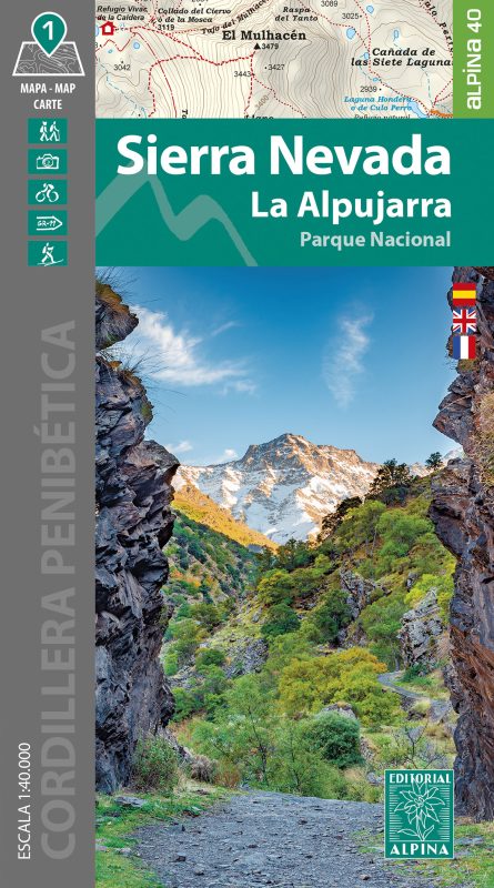
Goede wandelkaart van dit gebied met alle noodzakelijke informatie als berghutten, campings. Kleurgebruik vrij fel, waardoor hoogtes goed uitkomen. Wandelroutes zijn ingetekend en de GR paden (doorgaande wandelpaden) zijn weergegeven met een teken of nummer. Coordinaten zijn weergegeven, dus GPS compatible met UTM grid
Gebied: De Alpujarras staan er op tot en met Trevelez in het oosten. Met Granada, Lanjarrón, Nigüelas, Dúrcal, Restábal, Béznar, Trevélez, Bérchules, Bubíon, Capileira, Almegijar, Cástaras, Pinos del Valle, Dílar, Gójar, Monachil, Órgiva, Güejar-Sierra, Pradollano, Veleta, Mulhacén, La Alcazaba.
New Map of Sierra Nevada at 1:40,000 scale, the most important chain of mountains in the southern Iberian peninsula. It has the highest peaks, as in the case of Mulhacen at 3,479 m, and the peak Veleta which is the third highest at 3396 meters.
The map also includes a significant portion of the region of La Alpujarra. Overall, this area offers immense opportunities for hiking, mountaineering and mountain biking.A topographic tourist map with details of tourist attractions, hiking & sporting activities as well as transport information. An excellent folded map & booklet for the Sierra Nevada. GPS Compatible. • Scale: 1:40.000 • Heights of the most interesting spots of the area • Shady relief • UTM grid with divisions of 1 km • Compatible with GPS • Marked routes • Guidebook with hikes, potholing, gully descent, climbing, mountain biking and facts of interest
€ 16,95
Verzendkosten: € 2,95Specificaties
Merk:
n.b.
EAN:
Je bestelt bij:
De Zwerver
Categorie:
Subcategorie:
Maat:
n.v.t.
Materiaal:
n.v.t.
Levertijd:
Aantal beschikbaar:
n.b.
Verkoopprijs
€ 16,95
Prijzen vanaf:
n.v.t.
Verzendkosten:
€ 2,95
ISBN:
9788480909976
Editie:
01-01-2024
Uitgever:
Editorial Alpina
Beschrijft het volgende gebied:
Europa - Spanje - Andalusië - Zuid Spanje
Taal:
Spaans - Engels
Direct bestellen: