
Wandelkaart Yorkshire Dales Zuid Oost | Harvey Maps
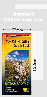
HARVEY launch innovative new series: Ultramap XT40. 16 titles featuring in Trail magazine through spring 2016. 40 years experience have gone into HARVEY's most creative new series. The Ultramap covers a large area yet is small enough to slip in a pocket. The Ultramap is fully detailed genuine original HARVEY mapping. The Ultramap is tough and 100% waterproof. Use it without a map case, whatever the weather! To provide the biggest area on the smallest lightest sheet, the Ultramap is printed double sided. The ingenious folding pattern allows you to open the Ultramap directly to any part and either side of the sheet. The two sides are aligned, so when you reach the edge of the Ultramap sheet you simply flip it over without re-folding. There's an overlap as well so you can map read continuously. The magic scale of 1:40,000 enables the Ultramap to provide all the detail you would expect to find on a large scale walking map including rights of way and boundaries. Actual size 73mm x 152mm. Plastic pocket for protection. Area covered: Pen-y-Ghent, Wharfedale, Nidderdale ans Malham Cove including Settle, Skipton and Grassington.
€ 19,50
Verzendkosten: Zie website leverancierSpecificaties
Merk:
n.b.
EAN:
Je bestelt bij:
De Zwerver
Categorie:
Subcategorie:
Maat:
n.v.t.
Materiaal:
n.v.t.
Levertijd:
Aantal beschikbaar:
n.b.
Verkoopprijs
€ 19,50
Prijzen vanaf:
n.v.t.
Verzendkosten:
Zie website leverancier
ISBN:
Editie:
Uitgever:
Beschrijft het volgende gebied:
Europa - Engeland -
Taal:
Direct bestellen: