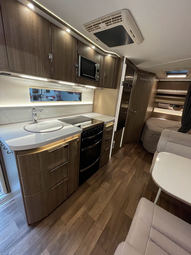
€ 22.50
Wandelgids Wild Swimming Walks near London | Wild Things Publishing

Wild Swimming Walks leads you on 28 adventures into the beautiful countryside of southern England. Discover swimming meadows along the Thames, secret coves of the Sussex seashore and hidden islands of the Essex coast. All the walking routes are accessible by train and each comes with ideas for places to visit and refreshments along the route. Includes suggestions for longer weekends away as well.


Includes downloadable route information to print out, or take with you on your phone or tablet.


The famous swimming ladies of London’s Hampstead ponds share their favourite walks with a dip. Leave the car at home this summer with 28 days out across southern and eastern England.


Featuring secret lakes, river meadows and sandy seaside beaches, Wild Swimming Walks is rich with stories, photos and natural history. Complete with detailed directions, maps and practical inspiration, this book is perfect for families, walkers and swimmers alike.


The Kenwood Ladies’ Pond on Hampstead Heath has been a women’s swimming pond since 1926. World famous for its history and idyllic setting, it has become a magnet for London residents and visitors alike. Margaret Dickinson (editor) is a year-round wild swimmer, documentary film-maker and writer who campaigned to save swimming on the Heath.


€ 17.50
Wegenkaart - landkaart 3209 Adventure Map Namibia - Namibië | National Geographic

Mooie, heldere kaart van Namibië, gedrukt op scheurvast en watervast papier.


National Geographic's Namibia Adventure Map is designed to meet the unique needs of adventure travelers with its durability and accurate information. Each folded map provides global travelers with the perfect combination of detail and perspective, highlighting the area’s terrain and best locations for adventure activities. Adventure Maps include hundreds of points of interest that highlight diverse and unique destinations within the country.


The map includes the locations of thousands of cities and towns with a user-friendly index, plus a clearly marked road network complete with distances and designations for major highways, main roads, and tracks and trails for those seeking to explore more remote regions.


Key Features:

Waterproof and tear-resistant

Detailed interpretive information and local travel tips

Detailed topography complete with activity symbols, ideal for exploring the country

City overview maps

Hundreds of points of interest, including the location of World Heritage sites, national parks and nature reserves, aboriginal settlements and protected lands, mines, archeological sites, wildlife parks and more

Thousands of place names

Important travel aids including airports, lighthouses, ferry routes and rail lines

Developed in cooperation with local agencies

Updated regularly to ensure accuracy

€ 14.95
Reisgids Culture Smart! Mongolia | Kuperard

De Cultuur Bewust!-gids geeft toeristen en zakenlieden belangrijke informatie met betrekking tot de cultuur van alledag in het land van bestemming. Anders dan in de gebruikelijke reisgidsen wordt de lezer in deze reeks bijgespijkerd op het gebied van omgangsvormen, normen en waarden, hoe zich te gedragen en wat verwacht mag worden op zakelijk en sociaal gebied. Het zijn beknopte zakformaatgidsen met interessante wetenswaardigheden over het dagelijks leven. Een must voor iedereen die naar het buitenland gaat voor vakantie, studie of werk.


Culture Smart! provides essential information on attitudes, beliefs and behavior in different countries, ensuring that you arrive at your destination aware of basic manners, common courtesies, and sensitive issues. These concise guides tell you what to expect, how to behave, and how to establish a rapport with your hosts. This inside knowledge will enable you to steer clear of embarrassing gaffes and mistakes, feel confident in unfamiliar situations, and develop trust, friendships, and successful business relationships.


Culture Smart! offers illuminating insights into the culture and society of a particular country. It will help you to turn your visit-whether on business or for pleasure-into a memorable and enriching experience. Contents include:


* customs, values, and traditions

* historical, religious, and political background

* life at home

* leisure, social, and cultural life

* eating and drinking

* dos, don'ts, and taboos

* business practices

* communication, spoken and unspoken


"Culture Smart has come to the rescue of hapless travellers." Sunday Times Travel


"... the perfect introduction to the weird, wonderful and downright odd quirks and customs of various countries." Global Travel


"...full of fascinating-as well as common-sense-tips to help you avoid embarrassing faux pas." Observer


"...as useful as they are entertaining." Easyjet Magazine


"...offer glimpses into the psyche of a faraway world." New York Times

€ 15.50
Reisverhaal Walking the Nile | Levison Wood

A major Channel 4 series and a Sunday Times bestseller

His journey is 4,250 miles long.
He is walking every step of the way, camping in the wild, foraging for food, fending for himself against multiple dangers.
He is passing through rainforest, savannah, swamp, desert and lush delta oasis.
He will cross seven, very different countries.
No one has ever made this journey on foot.
In this detailed, thoughtful, inspiring and dramatic book, recounting Levison Wood's walk along the length of the Nile, he will uncover the history of the Nile, yet through the people he meets and who will help him with his journey, he will come face to face with the great story of a modern Africa emerging out of the past. Exploration and Africa are two of his great passions - they drive him on and motivate his inquisitiveness and resolution not to fail, yet the challenges of the terrain, the climate, the animals, the people and his own psychological resolution will throw at him are immense.
The dangers are very real, but so is the motivation for this ex-army officer. If he can overcome the mental and physical challenges, he will be walking into history...

€ 23.95
Reisgids Croatia - Kroatië | Bradt Travel Guides

Een Engelstalige, praktische reisgids voor de avontuurlijke reiziger, boordevol informatie over accommodatie van budget tot luxe, vervoer, plaatsbeschrijvingen en natuur - kenmerk : kritisch op toeristische pleisterplekken en de stijl is verhalend.

This new edition of Bradt's Croatia is thoroughly updated to reflect recent changes, especially since Croatia's accession to the EU in 2013. Bradt's Croatia offers the most detailed coverage of all the guides of the coast and islands, as well as the capital Zagreb and areas further inland. New for this edition are: more details of Slavonia, new accommodation options in all price brackets, new restaurants, plus new features on Croatian wines and Game of Thrones locations and tours in Dubrovnik. Sitting at the cross-roads of Europe, Croatia offers an unrivalled mix of culture and nature. It continues to seduce visitors with its beautifully preserved historic towns and cities, magnificent cultural sights, gorgeous coastline, outstanding national parks and delicious food-not to mention some of the clearest waters you are likely to find anywhere in the Mediterranean. 

€ 13.95
Wegenkaart - landkaart England & Wales - Engeland | ITMB

Een degelijke kaart met aanduidingen van o.a. nationale parken, vliegveld, benzinepompen.

ITMB publishes a map of Great Britain, but each portion of GB needs its own map to show roads and attractions in more detail. This is a brilliant map of both England and Wales, showing the entire 'country' in a double-sided format. The place names index is formidable, but England in particular is a series of little villages, so it has been very difficult to decide what to include and what to leave out. This map is showing motorways, divided carriageways, all A & B highways, railway lines, airports, historic sites and touristic attractions, parks and gardens, and just about everything that we could fit on to the page to provide users with a detailed, usable map. We have been able to fit all of southern England/Wales as far north as Chester/Lincoln on side A and with a little overlap, from those cities north to the well over the Scottish border, up to Perth/Dundee filling side B. The Isle of Man and much of Northern Ireland are included as well as a bonus, with an inset map showing the Channel Islands and another inset showing central London. Apologies if we omitted something crucial; please advise. This is a brand new map, replacing the artwork we used in the past. Scotland was done as a double-sided map using the same data base and was released a couple of months ago. This is an excellent map for touring all of England/Wales 

€ 19.95
Wandelgids 6533 Sentier vers Saint-Jacques-de-Compostelle GR653 | FFRP

Franstalige wandelgids met een beschrijving van een aantal dagtochten / rondwandelingen. Uitstekende beschrijvingen met duidelijk kaartmateriaal. Mislopen is nauwelijks mogelijk, maar ja .. de franse taal! Ook praktische informatie staat in deze gids. Alle gidsen bevatten een door ons toegevoegde uitgebreide frans - nederlandse wandelwoordenlijst.

Ce topo-guide qui permettra aux pèlerins et randonneurs d’arpenter les sentiers de la via tolosana et, pour certains, de poursuivre leur périple entamé au fil des pages de "Sentier vers Saint-Jacques-de-Compostelle : Montgenèvre - Arles" (réf. 6531). 


Ce voyage en pays d’oc vous fera traverser 5 départements au patrimoine d’exception et aux paysages variés. Les villes de départ et d’arrivée sont à ce titre symptomatiques des richesses à admirer. À Arles, vous découvrirez notamment l’Eglise et le cloître Sainte-Trophime ainsi que le Théâtre antique et l’amphithéâtre. À Toulouse vous attendent le Pont Neuf, plus vieux pont de la ville, et la basilique Saint-Sernin, fondée pour abriter les reliques de saint Saturnin, qui comprend une nef romane vertigineuse et un déambulatoire à neuf absidioles.


Tout au long de votre avancée sur les sentiers, la nature vous offrira ses multiples trésors : marais et étangs de la Camargue, garrigue et vignes du Languedoc, massifs boisés et chaos granitiques de l’Hérault et du Tarn...

€ 22.95
Campergids Mit dem Wohnmobil Schottland | Bruckmann Verlag

Een mooie, rijk geillustreerde campergids over Schotland. Aan de hand van een aantal routes (zie overzicht) kun je deze gids goed gebruiken om engeland te berijden met een camper. Aan het eind van de beschrijving van de route vind je een pagina met praktische informatie over camper-overnachtingsmogelijkheden.

Sie möchten Wohnmobilcampen in Schottland, suchen Natur, Kultur und Abenteuer? Dann liegen Sie mit diesem Tourenführer richtig. Ob Edinburgh, Glasgow oder Dundee, ob Orkney-Inseln, Shetland-Inseln oder Isle of Skye, ob Whiskydestillerien oder Moore - erleben Sie Schottland in all seinen Facetten. Dieser Wohnmobilführer lotst Sie in sechs abwechslungsreichen Touren über die Insel - mit vielen wertvollen Tipps zu Stellplätzen und Landeskunde.

€ 16.50
Fietsgids Bikeline Venedig-Rom Radfernweg | Esterbauer

Praktische fietsgids met detailkaarten, ingetekende route, informatie over overnachten en fietsenmakers, zwaarte en hoogteprofiel. In spiraalbinding, Duitstalig.

Gleich zu Beginn der Tour werden Sie von dem wunderschönen Venedig verzaubert, das Sie per Schiff in die Strand- und Fischerwelt des Lido entlässt. Mit direktem Kontakt zum Meer erreichen Sie die kleine Schwester Venedigs, Chioggia. Von da an wenden Sie sich nun dem ebenen Binnenland zu und tauchen in die ruhige Naturlandschaft des Podeltas ein, bevor Sie sich wieder der mondäneren Welt des Strandlebens bis hinunter nach Ravenna zuwenden. Kulturell spannend wird es dann vor allem in Ravenna, Sie befinden sich nun schon mitten in der Region Emilia-Romagna. Hinter Ravenna erwarten Sie noch einige Kilometer in der landwirtschaftlich geprägten Ebene, dann erwartet Sie schon bald die erste sportliche Herausforderung dieser Tour, die Überquerung des Appenin. Inmitten der hügeligen Landschaft des Mugello erobern Sie sich die beliebte Ferienregion Toskana und die berühmte Hauptstadt der Region, Florenz. Nachdem Sie das geschichtsträchtige Zentrum der Toscana verlassen haben, tauchen Sie in das ebenso bekannte Chianti-Gebiet ein mit seinen Weingärten und ausgedehnten Wäldern. Sie weichen dann gen Osten ins Tal des Arno ab und gelangen entlang der Naturparks rund um die Stauseen des Arno in die sehenswerte Stadt Arezzo. Nachdem Sie wieder intensiv italienische Stadt- und Kulturluft geschnuppert haben, machen Sie sich entlang des Sentiero della Bonifica an den Ufern des Chiana-Kanals wieder auf gen Süden. Lassen Sie sich auf Ihrem weiteren Weg von dem schmucken Cortona bezaubern und genießen Sie den Blick auf die weite, stille Wasserfläche des Trasimeno-Sees. Nächster kultureller Höhepunkt ist dann die Hauptstadt der Region Umbrien, die Universitätsstadt Perugia mit ihren zahlreichen Sehenswürdigkeiten und mit typisch italienischem Flair. Ein weiterer Höhepunkt ist bald erreicht, die Pilgerstadt Assisi, hier wandeln Sie auf den Spuren des heiligen Franz von Assisi. Das folgende Wegstück ist geprägt von ruhigen Straßen und Radwegen in der Ebene und entzückenden Städten inmitten von Olivenhainen an Berghängen gelegen, die von kräftigen Radlerbeinen erobert werden wollen wie Spello, Trevi und Spoleto. Danach geht’s dann wieder so richtig zur Sache, nun ist Ihre Kondition wieder gefordert. Auf einsamen Wegen wandeln Sie bergauf und bergab bis nach Terni. Auf den Spuren von Römern und Etruskern überqueren Sie dann die Grenze zwischen der Region Umbrien und dem Latium. Entlang der Sabinischen Berge umfängt Sie eine Gegend, die sich ganz der Kultivierung des Olivenbaumes verschrieben hat, schmucke Orte auf charakteristischen Hügeln, den Poggi, geben Ihnen hier das Geleit, bevor Sie erstmals dem Tiber begegnen. Noch einmal erwartet Sie ein stetiges Auf und Ab durch hügelige Landschaft mit schönen Ausblicken, dann endlich ist das Ziel erreicht. Die Radler empfängt Rom mit einem wunderschönen Radweg entlang des Tibers, der Sie verkehrsfrei mitten in die quirlige Hauptstadt Italiens hineinführt, das sagenumwobene Rom, die Stadt der Superlative mit seiner unglaublichen Jahrtausende währenden Geschichte. 

Streckencharakteristik


Länge

Die Gesamtlänge der Strecke von Venedig über Florenz nach Rom beträgt rund 900 Kilometer. 


Wegequalität und Verkehr

Die Wegequalität ist insgesamt sehr gut, da die Route vor allem auf asphaltierten Straßen und Radwegen verläuft. Zwischendrin gibt es manchmal Wegstücke auf unbefestigtem Untergrund, der jedoch immer gut befahrbar ist. Wirklich verkehrsreiche Strecken begegnen Ihnen eher selten, nur auf vergleichsweise kurzen Strecken und in Stadtgebieten ist es uns manches Mal nicht gelungen eine ruhigere Alternative zu finden. 


Beschilderung

Es existiert keine Beschilderung zu dieser Radroute.

Abonneer op