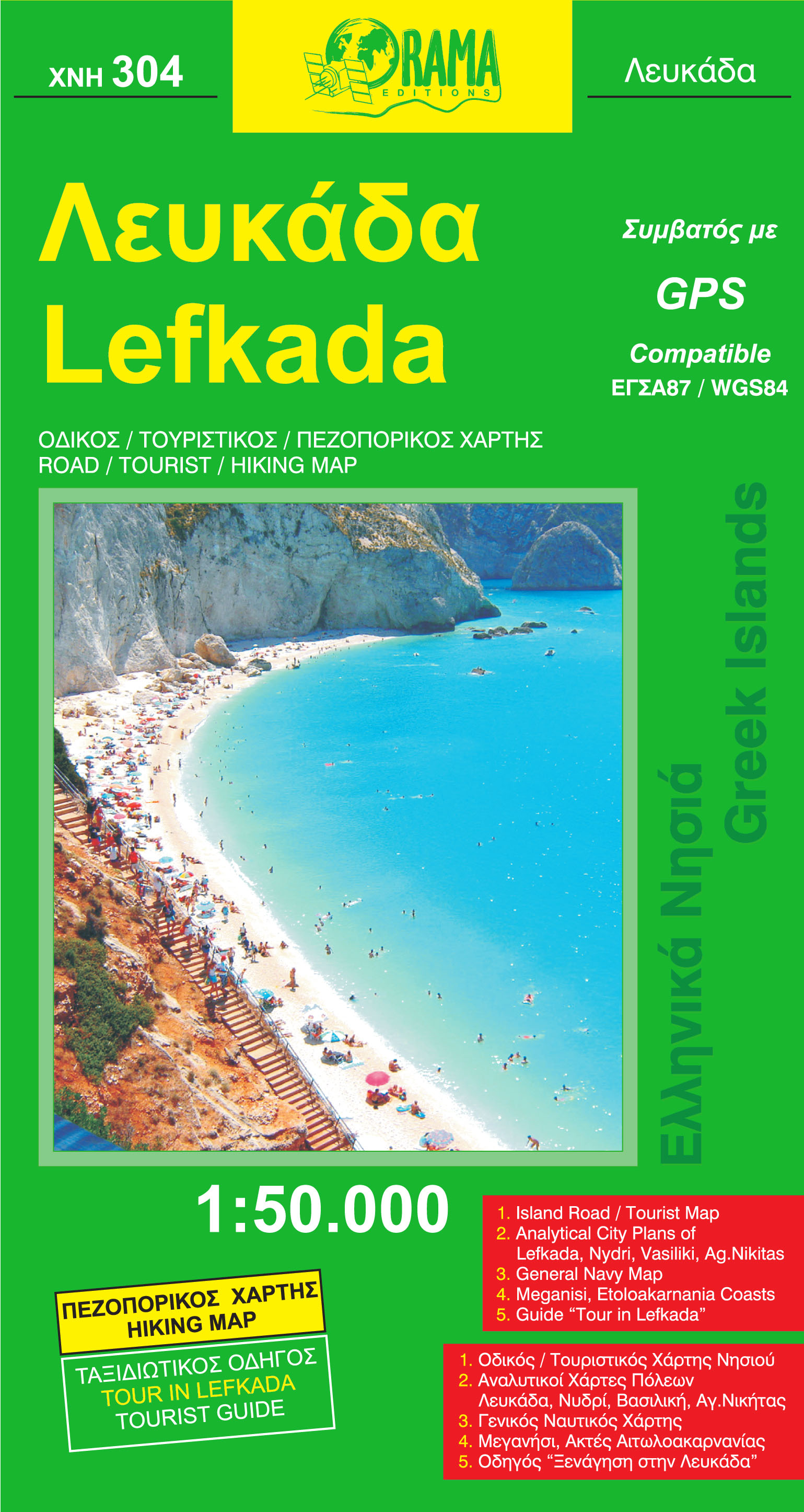
€ 14.95
Reisgids Marco Polo NL Rome | 62Damrak

de Nederlandse versie van de alom bekende en gewaardeerde serie van Marco Polo.


Het is een handige en overzichtelijke, kleine reisgids voor een  goede kennismaking met de vakantiebestemming. Globale uitklapkaart achterin, makkelijk binnenzakformaat. Toch best veel aandacht voor de toeristische hoogtepunten en leuke tips van en door de schrijvers die er vaker geweest zijn. 

€ 11.50
Wegenkaart - landkaart 25 Marco Polo Freizeitkarte Eifel, Aachen, Trier | MairDumont

Regionale kaart met veel praktische informatie als campings, bezienswaardigheden, fietsroutes etc.  Een handige kaart als je vanuit een bepaalde standplaats de omgeving wilt verkennen. Deze versie is geplastificeerd!


Zoals op het overzicht te zien is, blijkt niet heel Duitsland gedekt door deze serie. Zo zijn de landsgrenzen met Nederland niet in kaart gebracht door Marco Polo. Kijk dus goed op het overzicht hoe deze kaart uitgesneden is


Die reiß- und wetterfeste Karte enthält 66 Freizeit-Tipps, die am Kartenrand kurz beschrieben werden. Karte im Maßstab 1:100 000 mit Biergärten und Ausflugslokalen, Hofläden und Direktvermarktern sowie zehn Fahrradtouren.

€ 31.95
Vogelgids Birds of Botswana | Princeton University

Here is the ultimate field guide to Botswana’s stunningly diverse birdlife. Covering all 597 species recorded to date, Birds of Botswana features more than 1,200 superb color illustrations, detailed species accounts, seasonality and breeding bars, and a color distribution map for each species. Drawing on the latest regional and national data, the book highlights the best birding areas in Botswana, provides helpful tips on where and when to see key species, and depicts special races and morphs specific to Botswana. This is the first birding guide written by a Botswana-based ornithologist and the only one dedicated specifically to Botswana.

Portable and easy to use, Birds of Botswana is the essential travel companion for anyone visiting this remarkable country.

Covers all 597 species of birds found in Botswana, including subspecies and color variants specific to Botswana

Features more than 1,200 color illustrations—with more than one illustration for species where the sexes and ages differ

Includes detailed species accounts, seasonality and breeding bars, and color distribution maps

Draws on the latest bird data and the expertise of leading birders in Botswana

€ 22.95
Wandelgids Walking in Andalucia - Andalusië | Cicerone

Mooi en duidelijke wandelgids over bepaalde streken in Andalusië: goed beschreven wandelingen met een redelijke kaart. De tekst is behoorlijk kompleet. Daarnaast ook praktische informatie per route.

This guidebook explores six of Andalucía's most beautiful Natural Parks, the Sierra Nevada regions of Aracena, Grazalema, Los Alcornocales and the Gaucín, La Axarquía, the Alpujarras and Cazorla, along the great belt of the Cordillera Bética mountains. The thirty-six half-day and full-day mostly circular walks are evenly split within these six regions, and range in length from 4 to 21km. Walks are graded and some involve steep ascents and descents, all within the capabilities of a reasonably fit walker.

The vast mountain range of the Cordillera Bética offers some of the finest year-round walking in Europe. Towering above the Mediterranean, the highest peaks of the Sierra Nevada rise to almost 3500m, mainland Spain's highest mountains. And wrapped within this mighty belt of mountains are some of Spain's most beautiful villages and mountain trails.

The routes are based in and around the villages of Aracena, Grazalema, Jimena de la Frontera, Cazorla, Bubión and Cómpeta, all of which lie within protected Nature Reserves. They are best enjoyed mid-September through to mid-June, though mid-summer walks can still be comfortably undertaken in the higher Natural Parks of Cazorla and La Alpujarra. Alongside detailed route descriptions and clear mapping, the guidebook includes notes on the history of Andalucía and its plants and wildlife, practical information about travel, food and drink, language and communications and recommendations for the best places to stay.

The six areas covered by the guide are in and around the villages of Aracena, Grazalema, Jimena de la Frontera, Cazorla, Bubión and Cómpeta, all of which lie within protected Nature Reserves.

€ 29.95
Wereldkaart muursticker grijs | United Entertainment

World Map Grey

De World Map is een prachtige wanddecoratie voor je woonkamer of kantoor. Met de afmeting van 103 x 180 cm geeft de World Map een specifieke uitstraling aan je interieur. Een geweldig idee voor een nieuwe woning, liefhebbers van reizen of een ieder die een persoonlijke touch wil geven aan de leefomgeving.

De World Map is eenvoudig aan te brengen door gebruik te maken van het meegeleverde transparante sticker vel. Hierdoor is geen lijm nodig, laat het geen rommel achter en heb je geen schilder nodig. De World Map is aan te brengen op de meeste vlakke ondergronden.


- Materiaal: hoge kwaliteit mat vinyl

- Afmetingen: 103 x 180 cm

- Verwijderbaar, maar niet herbruikbaar

- Verkrijgbaar in black, grey, red


€ 13.95
Wegenkaart - landkaart - Stadsplattegrond Istanbul & Northwest Turkey | ITMB

Dubbelzijdige kaart van ITMB met aan een kant een wegenkaart  1:550.000 met aanduidingen van o.a. nationale parken, vliegveld, benzinepomp, dirt-roads. Als overzichtskaart goed te gebruiken. Aan de andere kant een overzichtelijke stadsplattegrond 1: 11.000 met stratenindex en aanduiding van toeristische informatie en culturele instellingen zoals musea, monumenten, schouwburgen en sportaccomodaties. Daarnaast bevaten de meeste kaarten een heldere aanduiding van het openbaarvervoer (opstappunten van metro), parkeergelegenheden, postkantoren en andere praktische informatie.

Istanbul is one of the most interesting cities in Europe. It is loaded with interesting places to see and places to go. The map shows all major touristic sites (my favourite is Constantine s Column), the ferry routes that criss cross the Bosphorus, and the transit lines that move everyone around the city. We have made a significant change to the regional map on the second side of the sheet; in this edition, we provide a very detailed map of North-eastern Turkey, from the Greek and Bulgarian borders south past Cannakele and Edremit and east to Bolu. This enables the user to focus on realistic driving/bussing times to reach destinations within a reasonable distance of Istanbul. Both maps combine to portray a fascinating city and region.

€ 29.95
Wandelkaart 2641 Turkart Hammerfest | Nordeca

Gebied: Finnmark


Uitstekende wandelkaart van een deel van Noorwegen. De Noren zelf gebruiken deze kaarten ook voor hun wandeltochten in de berggebieden. Afhankelijk van de moeilijkheidsgraad van het gebied voldoet een 1:25.000, 1:50.000 of 1:100.000 kaart. 


Alle noodzakelijke informatie vind je er op terug: bemande en onbemande hutten, campings, rivier-oversteken, wandelroutes en veelal ook langlaufroutes; daarnaast natuurlijk de topografische details als hoogtelijnen, soort landschap of wegennet. Met UTM grid.


De legenda is in het Noors en Engels, verdere informatie op de achterzijde van de kaart is in het Noors. De kaart wordt geleverd in een plastic hoesje.

€ 15.00
Leeslampje Desk Lamp Rood | Kycio

De Desk Lamp is een handig klein leeslampje voor aan je boek of op je bureau. Klem het lampje aan de bovenkant van je boek en klik op het knopje bovenop het lampenkapje het lampje aan (3 x LR41 batterijen meegeleverd). Dit leeslampje heeft LED verlichting en geeft helder en prettig leeslicht. Ook is de retro Desk Lamp te gebruiken op je bureau, klik dan het lampje in het bijgeleverde pootje zodat deze blijft staan.


- Materiaal: kunstof, LED

- Afmetingen: 10 cm

- Gewicht: 10 gram (lampje), 29 gram (inclusief pootje)

- Inclusief 3 LR41 batterijen

- Merk: Kycio

€ 12.50
Reisgids Rough Guide Pocket Berlin - Berlijn | Rough Guides

Een kleinere versie in zakformaat van de grotere versies van de Rough Guides. Als altijd weer vol met goede informatie over cultuur en praktische zaken. Achterin een kaart van de stad.

Pocket Rough Guide Berlin gives you the lowdown on one of Europe’s hottest cities, covering all the top bars, clubs, restaurants, shops and sights, and including a section on the best accommodation for every budget. Beautiful photography throughout completes the picture.


The itineraries section helps you plan your ideal Berlin experience, while “Best of Berlin” gives an inspirational overview of all the must-sees, from the Reichstag to the East Side Gallery and Strandbad Wannsee.


Written in Rough Guides’ trademark honest and informative style, the “Places” chapters cover the city area by area, moving you from vibrant and bustling Spandauer Vorstadt – Berlin’s downtown – to up-and-coming areas like Wedding and colourful East Kreuzberg.


Make the most of your mini-break with the Pocket Rough Guide Berlin


€ 16.50
Wegenatlas Trans-Siberian Railroad | ITMB

Klein formaat wegenatlas (A5) van de Trans-Siberische spoorlijn, uitgebracht door ITMB.

It is not often that one can publish a map that has never been done before. I seem to say that rather frequently! The Trans Siberian is one of the great railway trips of all time, crossing vast areas of steppe land and tundra as it wends its way from Moscow to Vladivostok. There are actually two routes for much of the western portion, and branch off lines to Mongolia and northern China in the east, as well as a very unusual route across the top of Lake Baikal called the Amur, or BAM, line. The only effective way to show east west rail networks this diverse is via an atlas and that is just what we have done. The entire route, with an extra page for those starting in St. Petersburg is covered nicely, with inset pages showing St. Petersburg, Moscow, and the heritage cities of Sergiev Posad and Suzdal. Both branches of the Trans-Siberian are shown and most of the Baikal Amur (BAM) line. This type of map has never been attempted before, so we are anxious to receive feedback.

Abonneer op