€ 18.50
Wandelgids Walking in Cumbria's Eden Valley - Lake district | Cicerone

Uitstekende Engelstalige wandelgids van dit prachtige gebied op de grens van Engeland en Schotland.

Guidebook to 30 of the best walks in Cumbria's enchanting Eden Valley. The graded routes, which range from 3 to 15 miles, explore the region's diverse landscapes and offer dramatic views, either of the Pennines, the Lake District or the Scottish hills. 

The walks, which work well from bases such as Kirkby Steven, Dufton and Appleby, are predominantly circular. Some of the linear routes link with the Settle-Carlisle railway. Map extracts from the 1:50K OS Landranger series accompany route description, and the handy route summary table makes it easy for walkers to compare routes. Invaluable information on transport, accommodation, clothing, equipment and safety is included, as are notes on the region's geology, wildlife and history.


Situated next to the iconic Lake District, the Eden Valley is often overlooked as a walking destination. This works in its favour - it is as quiet as it is scenic - making it the perfect destination for those looking to escape the crowds. The featured routes are designed to give the walker a taste of everything the area has to offer. From peaceful woodland strolls to serious moorland hikes, and from explorations of the limestone uplands to walks on the Solway marshes, they visit just about every nook and cranny in the valley.


Steden en Dorpen

Kirkby Stephen, Appleby, Crosby Ravensworth, Dufton, Penrith, Kirkoswald, Armathwaite, Brampton, Carlisle.

€ 25.95
Wandelgids The John Muir Trail | Cicerone

Een uitstekende beschrijving van het beroemde lange afstandspad in Californie.

Guidebook to walking the John Muir Trail through California's High Sierra from Yosemite (El Capitan and Half Dome) to the summit of Mount Witney. The 216 mile hike is split into 21 daily stages, with full information on preparation, permits, wilderness, bears, water and trekking skills. Part of the Pacific Crest Trail.

The John Muir Trail (JMT) is one of the world’s most spectacular treks and is North America’s best known mid-distance walking trail. It runs for 216 miles through the high Sierra Nevada mountains of California, from Yosemite Valley to the summit of Mount Whitney (14, 496ft), the highest peak in the USA outside Alaska. The walking trail, which is named after the great 19th-century Scottish naturalist, conservationist and writer John Muir, is entirely through the unspoilt wilderness of the American West and passes through three national parks: Yosemite, Kings Canyon and Sequoia National Parks.

To walk the John Muir Trail successfully thorough planning is required. All you need to know to plan and prepare for your trip is contained within these pages, from obtaining trekking permits to buying trek food and forwarding food caches along the trail. Abundant advice is given on such topics as dealing with inquisitive bears, coping with altitude, negotiating river crossings, as well as tips on booking transport to and from the trailheads and on what equipment to take. In addition there is a detailed description of the flora and fauna of this remarkable region.

Steden en Dorpen

Starts Yosemite and finishes at Whitney Portal; Tuolmmne, Vermilion Resort and Muir Trail Range along the way; access through San Francisco or Los Angeles

€ 25.95
Wandelgids The Mountains of Montenegro | Cicerone

Bijzondere wandelgids van een bijzonder land in opkomst: goed beschreven, met veel informatie en details, dus zeer bruikbaar!

This guidebook includes a range of day-walks and multi-day treks throughout the Dinaric Alps of Montenegro. These mountains are some of the wildest, most spectacular, and least visited in Europe. Nevertheless they are easily accessible, and many areas have well-marked trails. They present an opportunity to travel through outstandingly beautiful and remarkably unspoilt natural scenery, which sees few visitors. The guide covers the most spectacular mountain areas in Montenegro, with a selection of circular and linear routes, with variants and extensions.


The guide also includes generous background information, including mountain huts and shelters, travel to and within the country, history and language, as well as what to expect in the various mountains and National Parks the routes explore. This is the first comprehensive English-language guide to walking in this beautiful area, and provides and ideal gateway into Montenegrin adventures.


Durmitor National Park - Žabljak Prokletije National Park - Gusinje Biogradska Gora National Park - Mojkovac Lake Skadar National Park - Virpazar Lovćen National Park - Kotor or Cetinje Orjen - Herceg Novi


€ 24.95
Wandelgids Beieren - Walking in the Bavarian Alps | Cicerone

Wandelgids met dagtochten: goed beschreven met veel praktische informatie om de route te kunnen lopen, inclusief redelijke kaarten. Enorm veel keus in een groot gebied!

This guidebook of walks explores Germany's Bavarian Alps. Lying along the German-Austrian border in a thin sliver of land roughly 300km long, this area contains some of the most spectacular walking and beautiful scenery that Germany has to offer. 70 graded walks explore mountain landscapes, wild mountain gorges and alpine meadows as well as the region's picturesque villages, opulent baroque churches and fairy-tale castles like Neuschwanstein. The walks are divided into six mountain areas, grouped around base towns to make planning a walking holiday as easy as possible.

Bases include Oberstdorf, Garmisch-Partenkirchen, Mittenwald, Marquartstein, Inzell, Oberammergau and Ramsau among others. Mountain walks are mainly between 3 and 8 hours duration, though some longer walks are included staying at mountain huts. The guidebook gives an outline of two multi-day tours and suggestions for shorter valley walks of less than 3hrs are also included. Relaxing beer gardens, colourful local traditions and excellent tourist infrastructure add to the region's charms, and make the Bavarian Alps the perfect destination for a walking holiday

Steden en Dorpen

Oberstdorf, Riezlern, Tannheim, Füssen, Garmisch-Partenkirchen, Mittenwald, Walchensee, Lenggries, Tegernsee, Bayrischzell, Marquartstein, Reit im Winkl, Ruhpolding, Inzell, Bad Reichenhall, Ramsau, Berchtesgaden

€ 18.50
Wandelgids Walking guide Isle of Man Coastal Path | Cicerone

Perfect wandelgidsje met geweldige routes op dit prachtige eiland tussen Engeland en Ierland. Goed beschreven, met veel details om de wandelingen te kunnen volgen, kaartmateriaal voldoende.

Guidebook to walking the Isle of Man coastal path, the Way of the Gull (Raad ny Foillan). The spectacular 98 mile route is described in 9 stages and takes in beaches, glens, moorland and rugged sea cliffs. It can be walked in around a week. Two other paths, the Millennium Way (Bayr ny Ree) and the Herring Way (Bayr ny Skeddan), are also described.


Seasons 

Year-round walking on the Isle of Man is possible, although spring and summer weather is best. April, May and June are driest; May, June and July are sunniest; July and August are warmest.


Centres  

Douglas, Ramsey, Castletown, Port Erin, Peel, Kirk Michael


Difficulty

Mainly coastal walking with short ups and downs. Stages up to 15 miles long.


Must See  

Point of Ayre, historic Laxey, the cliffs and secluded bays and inlets of the south and west and the remote west coast. Sea life and birds.

€ 21.95
Wandelgids Trekking in the Stubaier Alps | Cicerone

Uitstekende wandelgids van Cicerone over de Stubaier Alpen, waarbij de nadruk ligt op een tweetal meerdaagse routes: Huttentochten voor een gemiddelde en wat meer gevorderde wandelaar. Goede praktische informatie, kaartmateriaal beperkt.

Aanbevolen wandelkaarten bij deze gids

Schaal 1:25.000

Wandelkaart 31/1 Alpenvereinskarte Stubaier Alpen - Hochstubai

Wandelkaart 31/2 Alpenvereinskarte Stubaier Alpen - Sellrain

Of schaal 1:50.000

Wandelkaart 83 Stubaier Alpen Kompass
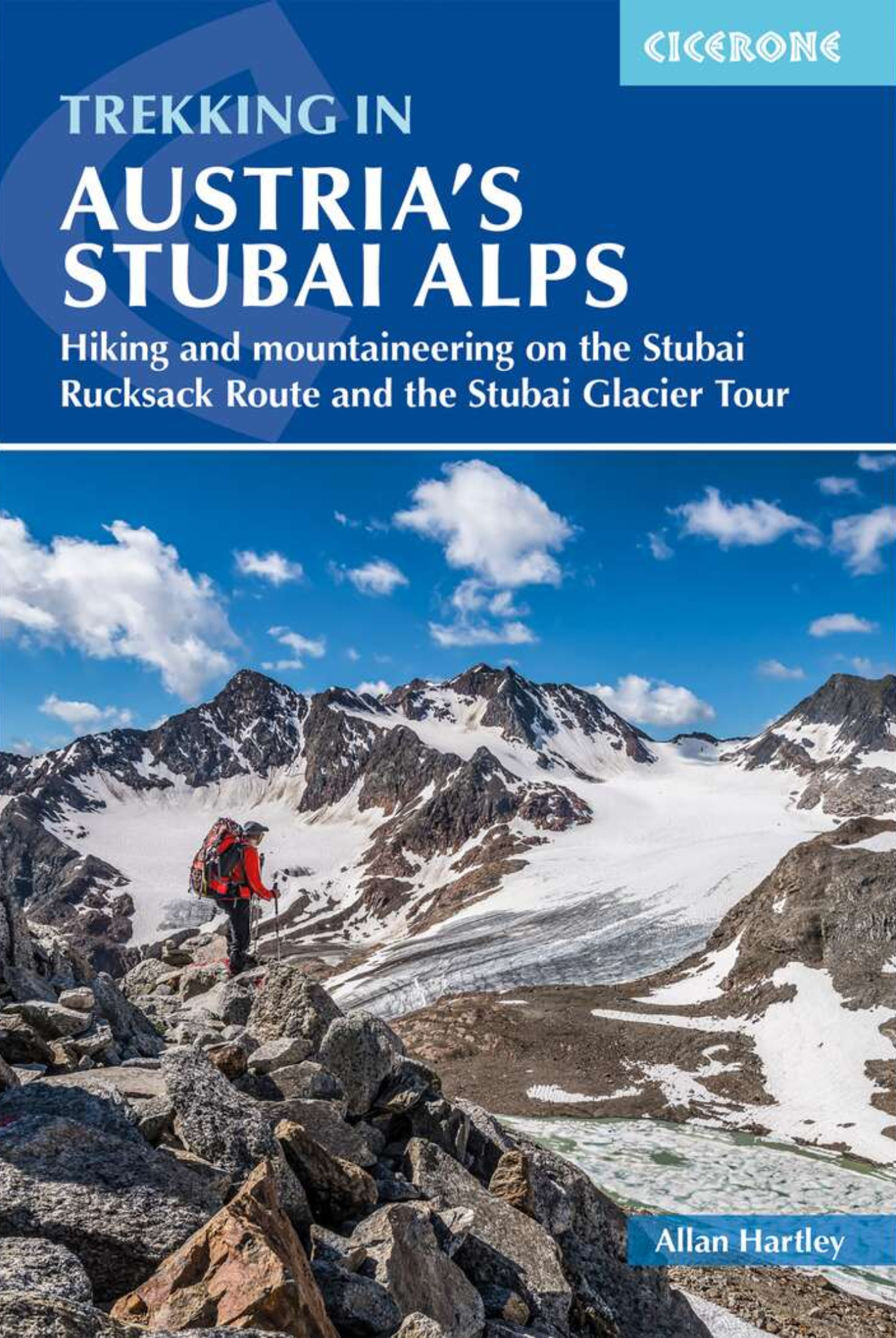
Of all the many Alpine areas, few can match the Stubai in the Austrian Tyrol as a venue for a first Alpine season. Shapely peaks, good paths and some of the best huts in the Alps make it ideal for the novice who wants to extend their experience beyond Britain.

Of all the many Alpine areas, few can match the Stubai in the Austrian Tyrol as a venue for a first Alpine season. Shapely peaks, good paths and some of the best huts in the Alps make it ideal for the novice who wants to extend their experience beyond Britain.

This third edition of the guide describes two celebrated routes, the Stubai Rucksack Route and the Stubai Glacier Tour. The Stubai Rucksack Route is an ideal route for the novice mountain walker, and links eight huts without crossing glaciers or difficult passes. The Stubai Glacier Route – known as the Höhen Weg – is a hut-to-hut tour through the best of the Stubai that crosses glaciers and has ample opportunities for ascents of easy peaks. Both routes can be accomplished in eight to ten days.

Both tours are given their own brief introduction with profiles of the route and other vital information and illustrated with colour photographs and sketch maps.The Introduction provides vital transport, language, accommodation and equipment information and the hut directory at the back gives full and up-to-date information about all the mountain huts along the routes.

Introduction
Villages of the Stubai and Stubaital
When to Go
Getting to Austria
Places to Stay
About Innsbruck
Tourist Offices
Post and Post Offices
Places to Leave Luggage
Taking Children
Emergencies, Mountain Rescue and Insurance
The Austrian Alpine Club
About Huts
Using this Guide
Maps and Guidebooks
Alpine Walking Skills and Equipment
Kit List
Mountain Guides

Stubai Rucksack Route and Round Tour
Introduction

Alternative Start
Stage 1A: Mieders to Klostergasthof Maria Waldrast
Ascent of Serles and Lampermahd Spitze from Klostergasthof Maria Waldrast
Stage 1B: Klostergasthof Maria Waldrast to the Padasterjoch Haus
Stage 1C: Padasterjoch Haus to the Innsbrucker Hut

Main Route
Stage 1: Neder to the Innsbrucker Hut
Ascent of the Habicht from the Innsbrucker Hut
Ascent of the Kalkwand from the Innsbrucker Hut
Stage 2: Innsbrucker Hut to the Bremer Hut
Stage 3: Bremer Hut to the Nuernburger Hut via Simmingjochl
Ascent of the Ostlicher Feuerstein from the Simmingjochl
Ascent of the Aperer Feuerstein from the Simmingjochl
Stage 4: Nuernburger Hut to the Sulzenau Hut
Stage 4A: Via the Niederl
Stage 4B: Via ascent of the Mair Spitze
Stage 4C: Via ascent of the Wilder Freiger
Stage 5: Sulzenau Hut to the Dresdner Hut
Stage 5A: Via the Peiljoch
Stage 5B: Via the Grosser Trogler
Ascent of the Schaufel Spitze from the Dresdner Hut
Stage 6: Dresdner Hut to the Neue Regensburger Hut via the Grawagrubenneider
Stage 7: Neue Regensburger Hut to the Franz Senn Hut via the Schrimmenneider
Ascent to the Rinnen See from the Franz Senn Hut
Ascent of the Sommerwand from the Franz Senn Hut
Ascent of the Lisenser Ferner Kogel from the Franz Senn Hut
Stage 8: Franz Senn to the Starkenburger Hut
Ascent of Hoher Burgstall from the Starkenburger Hut
Stage 9: Starkenburger Hut to Neustift

Alternative Finish
Stage 9A: Starkenburger Hut to Fulpmes

The Stubai Glacier Tour (Hoehen Weg)
Introduction

Stage 1: Milders to the Franz Senn Hut
Stage 2: Franz Senn Hut to the Amberger Hut via the Wildgrat Scharte
Ascent of the Schrankogel from the Schwarzenberg Ferner glacier
Stage 3: Amberger Hut to the Hoch Stubai Hut via the Wuetenkar Sattel
Stage 4: Hoch Stubai Hut to the Hildesheimer Hut via the Bildstoeckljoch
Ascent of the Schaufel Spitze from the Schaufeljochbahn
Stage 5: Hildesheimer Hut to the Mueller Hut via the Zuckerhuetl and Wilder Pfaff
Alternative Poor Weather Routes
Stage 5A: Hildesheimer Hut to the Siegerland Hut
Stage 5B: Siegerland Hut to the Mueller Hut via the Sonklar Spitze
Stage 6: Mueller Hut to the Nuernburger Hut via the Wilder Freiger
Stage 7: Nuernburger Hut to Ranalt, Neustift and Innsbruck

Hut Directory
Appendix A: Useful Contacts
Appendix B: Useful German Words and Phrases
Appendix C: Further Reading

Index

€ 18.50
Wandelgids 305 Marche - Marken - Adriaküste | Rother Bergverlag

Uitstekende wandelgids met een groot aantal dagtochten in dal en hooggebergte. Met praktische informatie en beperkt kaartmateriaal! Wandelingen in verschillende zwaarte weergegeven in rood/blauw/zwart.

Die Adriaküste wird seit Jahrzehnten mit reinem Badevergnügen gleichgesetzt. Millionen Mitteleuropäer haben dort schon ihren Sommerurlaub verbracht. Kaum bekannt ist allerdings, dass sich jenseits des schmalen Küstenstreifens eine der vielfältigsten Wanderlandschaften Italiens erstreckt. In den Marken und in der Romagna - so die Namen des Gebiets, das hier beschrieben wird - findet sich das ebene, von Kanälen durchzogene Podelta, liebliche Hügellandschaften, bizarre Schluchten in den Gessi Bolognesi und das Küstengebirge Monte Conero. Im Westen geht das von Kastanien- und Buchenwäldern bedeckte, von tiefen Schluchten durchzogene Vorgebirge langsam in den zentralen Apennin über. Alpine Touren sind in den bis auf 2500 m ansteigenden Monti Sibillini und in den südlich angrenzenden Monti della Laga möglich. Im Gegensatz zur nahen Küste hat das Hinterland der Adria an vielen Stellen seine Ursprünglichkeit bewahrt, so ist die Gegend noch ein Geheimtipp für Wanderer, die Stille und Beschaulichkeit suchen. Und die Infrastruktur ist erstaunlich gut. 50 ausgewählte Tagestouren, die größtenteils als Rundwanderungen konzipiert sind, befriedigen alle Ansprüche. Es wurde darauf geachtet, dass Zeit bleibt, die Sehenswürdigkeiten am Wege mit Muße zu betrachten: römische Ausgrabungen und malerische Städtchen, versteckte Kirchen und Klöster, Burgen und Schlösser. Farbbilder, farbige Wanderkärtchen und aussagekräftige Höhendiagramme zu jeder Tour ergänzen die ausführlichen Routenbeschreibungen.