
Wegenkaart - landkaart 106 Kythnos | Road Editions
Gedetailleerde wegenkaart met aanduiding van de wandelwegen, lijst van hotels en toeristische informatie. Voor alle doeleinden een zeer geschikte kaart.
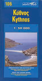
It was published in 2003, based on data of that same year. The geophysical background was provided by the Hellenic Military Geographic Service and there are contour lines at 20m intervals as well as a full hydrography (all ravines and dry torrents are visible). As in all ROAD maps, all beaches are illustrated in blue with their names, as are all location names of villages and settlements and of course the precise distances in kilometers from intersection to intersection.
This map introduces an innovation in that the locations of the early Cycladic (or protocycladic) metal smelting centres are indicated by a special symbol (the locals call these locations 'skouries' or 'rust marks') and it is especially worthwhile to see them.
On the back of the map, there are photographs of characteristic Kythnos landscapes, historical data and information for tourists and a listing of the accommodations available on the island.
€ 8,25
Verzendkosten: € 2,95Specificaties
Merk:
n.b.
EAN:
Je bestelt bij:
De Zwerver
Categorie:
Subcategorie:
Maat:
n.v.t.
Materiaal:
n.v.t.
Levertijd:
Aantal beschikbaar:
n.b.
Verkoopprijs
€ 8,25
Prijzen vanaf:
n.v.t.
Verzendkosten:
€ 2,95
ISBN:
9789608189140
Editie:
None
Uitgever:
Road Editions
Beschrijft het volgende gebied:
Europa - Griekenland - Cycladen Zuid
Taal:
Engels
Direct bestellen: