€ 19.50
Wandelkaart Trossachs Noord | Harvey Maps

Covers a large area yet is handily compact. Pocket perfect!


Detailed map for runners and walkers of the northern section of the Trossachs National Park at the magic scale of 1:40,000. Includes Loch Lyon and Crianlarich.


Includes the iconic Ben Lui and the Cononish Gold Mine.


All 7 Crianlarich Munros on one side of the sheet.


22 Munros, 14 Corbetts and 5 Grahams

€ 19.95
Wandelgids Escapardenne Eisleck Trail | Aparté Editions

Let op! Franstalige gids!


Topografische gids voor grensoverschrijdende wandeltocht.


Escapardenne Eisleck - Eislek  Trail loopt over 104 km van Kautenbach naar La-Roche-en-Ardenne door een schitterend deel van de Ardennen. Een nieuw langeafstandspad dat het Groothertogdom Luxemburg verbindt met de Waalse provincie Luxemburg. Grensoverschrijdend dus en niet alleen letterlijk! Dit is het eerste wandelpad in de Benelux dat werd ontworpen volgens de strenge Europese normen voor een 'Leading Quality Trail'. Terecht werd EscapArdenne Eisléck Trail dan ook bekroond met dat Europese label bij de opening eind 2012. Als wandelaar krijg je een continue afwisseling van wilde Ardennenlandschappen, oude karakterdorpen, prachtige panorama's en stille natuurgebieden voorgeschoteld


Kautenbach - Munshausen - Clervaux - Asselborn - Houffalize - Nadrin - La Roche en Ardenne

€ 7.95
Wegenkaart - landkaart Pocket Map Cornwall | Collins

Handzame wegenkaart voor Cornwall

This handy little full color map of Cornwall is an excellent value and very detailed for its size. Key features include clear mapping at a scale of 8.7 miles to 1 inch; National Tourist Routes showing the best routes through the most scenic areas; Top 100 places of interest; and Park and Ride locations. An ideal companion to a sat nav, it enables route planning and route sense-checking. Essential for those planning a trip.

€ 18.95
Natuurgids The Nature of Arizona | Waterford Press

An Introduction to Familiar Plants, Animals and Outstanding Natural Attractions


A land of contrasts, Arizona’s diverse landscape encompasses habitats ranging from the subalpine meadows of the San Francisco Peaks, to sunbaked deserts, to the mile-deep recesses of the world’s greatest canyon. Native species include more than 475 birds, 130 mammals, 90 reptiles, 20 amphibians, 80 fishes and thousands of trees, shrubs and wildflowers. This beautifully illustrated field guide highlights more than 300 common and unique plants and animals and 100 of the state’s outstanding natural attractions. It is an indispensable single reference for amateur naturalists, students and tourists alike.

€ 12.95
Wegenkaart - landkaart 798 Great Britain & Ireland | Michelin

Scheur- en watervast!


Zoals je van Michelin mag verwachten is deze kaart zeer overzichtelijk en heeft een duidelijk helder kaartbeeld. De kaart geeft uitgebreid toeristische informatie weer. Met register, afstanden en reistijden.


Wegen worden naar verschillende klasse ingedeeld en - mooi van Michelin - de interessante mooie routes worden gemarkeerd met een groene streep. 

Hindernissen voor automobilsiten met caravans zijn gemarkeerd: steile hellingen, bergpassen of een anderzins moeilijke route.

Bezienswaardigheden als een kasteel, religieus gebouw, ruine of grot is door een symbool goed te vinden.


MICHELIN National Map Great Britain & Ireland High Resistance will give you an overall picture of your journey thanks to its clear and accurate mapping scale 1/1,000,000. Our map will help you easily plan your safe and enjoyable journey in thanks to a comprehensive key, a complete name index as well a clever distance & time chart. Michelin's driving information will help you navigate safely in all circumstances. Durable this map will resist time and usage thanks to its tear and water-proof paper perfect for motorbiking. 


Belfast, Birmingham, Cork, Derry/Londonderry, Dublin, Galway, Irlande, Killarney, Limerick, Liverpool, Londres, Manchester, Waterford

€ 27.99
Reisgids National Geographic Droomreizen in Europa | Kosmos Uitgevers

Droomreizen in Europa neemt je mee naar bekende en minder bekende bestemmingen van Europa. Een prachtige uitgave met schitterende fotografie, die is samengesteld door de legendarische reisschrijvers van National Geographic. De perfecte leidraad voor reizigers die hunkeren naar avontuurlijke reizen. Elke mogelijke vorm van transport wordt besproken en elk hoofdstuk bevat verbluffende fotografie, kaarten in kleur en praktische tips. Informatief en inspirerend; dit luxueuze boek is een levenslange bron van inspiratie.

€ 10.95
Wandelkaart 07 Maintal-Odenwald | Geo-Naturpark Bergstraße-Odenwald

Gedetailleerde wandelkaart van dit gebied.


Freizeitkarte im Detailmaßstab 1:20.000 mit allen Wanderwegen und den in der Natur beschilderten Radwanderwegen. Mit dem zertifizierten Premiumwanderweg Nibelungensteig sowie den Qualitätswegen und den Hauptwanderwegen des Odenwaldklubs im Kartenbereich. Ebenso enthalten sind alle kommunalen Rundwanderwege und die Rundwanderwege des Geo-Naturparks ausgehend von den Naturpark-Parkplätzen.

Wanderwegbeschreibungen auf der Rückseite.


Mit Amorbach, Bürgstadt, Eichenbühl, Freudenberg, Kleinheubach, Laudenbach, Miltenberg, Rüdenau, Schneeberg und Weilbach.

€ 12.95
Wegenkaart - landkaart Scottish Whisky Distilleries Map | Schotse whiskystokerijen | Nicolson

Our brand new and up to date whisky map shows over 150 distilleries on our exceptionally clear road mapping, allowing you to navigate to your chosen destination. Enlarged inset map of Speyside & clearly defined production regions allows you to plan your distilleries tour according to your taste buds! Distilleries are indexed with addresses and full contact details and clearly defined as those with and without visitor facilities. The best thing to go with your dram apart from a splash of water. Foreword by Blair Bowman, whisky consultant Over 150 whisky distilleries shown with & without visitor facilities Clearly defined whisky producing regions Exceptionally clear road mapping with mileage markers Index to distilleries with full address & contact details Fun facts & information on the reverse Index to place names.

 Distilleerderijen in Schotland

€ 19.50
Wandelkaart Ben Lawers & Schiehallion | Harvey Maps

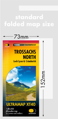
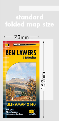
40 years’ experience have gone into HARVEY’s most creative new series. Slim and light, the Ultramap covers a large area and yet is handily compact. Pocket perfect!


Includes Ben Lawers, Schiehallion and the Tarmachan Ridge.


Includes 16 Munros and 6 Corbetts.


The Ultramap covers a large area yet is small enough to slip in a pocket

The Ultramap is fully detailed genuine original HARVEY mapping.

The Ultramap is tough and 100% waterproof. Use it without a map case, whatever the weather!

To provide the biggest area on the smallest lightest sheet, the Ultramap is printed double sided.

The ingenious folding pattern allows you to open the Ultramap directly to any part, and either side, of the sheet

The two sides are aligned, so when you reach the edge of the Ultramap sheet you simply flip it over without re-folding. There’s an overlap as well, so you can map read continuously

The magic scale of 1:40,000 enables the Ultramap to provide all the detail you would expect to find on a large scale walking map, including rights of way and boundaries

Plastic pocket for protection

€ 24.95
Wandelkaart Cheviot Hills | Harvey Maps

Includes the Cheviot, Newton Tors and Kirknewton. Detailed map for hillwalkers and cyclists of the Cheviot Hills at 1:25,000 scale. Includes the northern section of the Pennine Way from Brownhart Law to Kirk Yetholm. Tough, light, durable and 100% waterproof Genuine, original, HARVEY mapping Includes Rights of Way Opens directly to either side of the sheet Easy to re-fold

Abonneer op