€ 17.50
Wandelatlas South West Coast Path - Vol 2: St Ives to Plymouth | Cicerone

Heel handig bedacht van uitgever Cicerone: een boekje dat dienst doet als atlas met alle topografische kaarten die je nodig hebt voor het lopen van een gedeelte van de South West Coast Path. Past goed in binnenzak of broekzak.

Map of part of the southern section of the 630 mile (1014km) South West Coast Path National Trail. Covers the trail from St Ives to Plymouth along the west Cornwall and Devon coastline. This convenient and compact booklet of Ordnance Survey 1:25,000 maps shows the route, providing all of the mapping you need to walk the trail in either direction.

€ 22.50
Wandelgids Trekking the Cotswold Way | Knife Edge Outdoor

The definitive two-way guide to the Cotswold Way: both southbound and northbound routes are described in full.
Real Maps: Full Ordnance Survey mapping inside (1:25,000). All accommodation is numbered and marked on the maps.

18 different itineraries: schedules of 4, 5, 6, 7, 8, 9, 10, 11 and 12 days for hikers and runners. Includes both southbound and northbound itineraries. Difficult calculations of time, distance and altitude gain/loss are done for you.

Also includes:
- Detailed information on equipment and travelling light
- Everything the trekker needs to know: route, costs, difficulty, weather, travel, and more
- Full accommodation listings: the best inns, B&Bs and hotels
- Detailed section on camping
- What to see in the City of Bath
- Essential info for both self-guided and guided trekkers
- Information on history, plants and wildlife
- Numbered waypoints linking the Real Maps to our clear descriptions

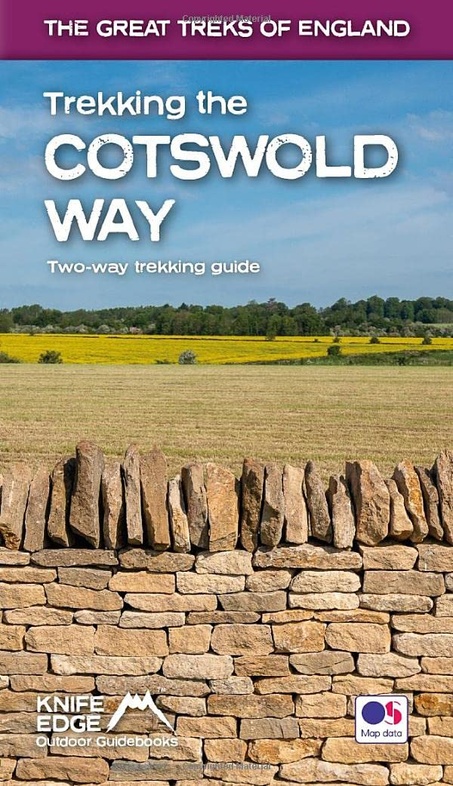
The Cotswold Way travels 102 miles through the sublime scenery of the Cotswolds, a region which is the epitome of historic England. Along the way, you will travel the crest of the Cotswold Escarpment through exquisite rolling countryside and historic chocolate-box villages, built from lovely honey-coloured stone, which have remained unchanged for centuries.

The trekker negotiates this wonderful terrain on a meticulously waymarked series of paths and tracks, far removed from the region's large urban centres. Occasionally, you will pass through a small village or hamlet (with little more than a local pub and a few places to stay) but otherwise, the experience is one of tranquillity. This is England at its best and it will be an adventure that you will never forget.

€ 24.99
Reisgids Lost & Dark Places Harz | Bruckmann Verlag

Lost Places Sachsen-Anhalt: Düster durch den Harz


Geschichten mit Gruselfaktor abseits der bekannten Tourismusattraktionen. Der erste Dark Tourism Guide für den Harz. Walpurgisnacht auf dem Brocken, ein Einhorn in einer Höhle, Barbarossas Bart im Marmorstein: Seit jeher ist der Harz bekannt für seine Mythen und Sagen. Doch es geht noch mystischer! Auf einer Reise durch die Vergangenheit dieser ausgewählten Lost Places: ein verlassenes Ferienheim, eine marode Burgruine, Betonrelikte mitten im Wald... Folgen Sie den Spuren dieser vergessenen Orte durch den Harz. Zwischen Staunen, Kopfschütteln und Gänsehaut.


Wanderführer Mittelgebirge: Der erste Dark Tourism Guide über den Harz


Fesselnd: 33 Lost & Dark Places und ihre Geschichte


Schaurig: mit Tipps, wie man die Atmosphäre der Orte am besten erleben kann

€ 17.95
Reisgids 111 plekken in Amsterdam die je gezien moet hebben | Thoth

* Een gids en leesboek over onbekende en

verrassende plekken in Amsterdam

* Met idyllische locaties voor zomergenot

* Bijzondere hotspots, gekke musea en

bruisende broedplaatsen

Bas van Lier (1961) is journalist, schrijver van bedrijfsgeschiedenissen

en andere

opdrachtpublicaties

en auteur van non-fictie voor kinderen. Bij Uitgeverij THOTH

publiceerde hij eerder een biografie van zijn grootvader: Carel van Lier 1897-1945

- Kunsthandelaar, wegbereider.

Zelfs voor geboren en getogen Amsterdammers kent de stad vele geheimen en onbekende plekken. Verscholen hofjes in de Jordaan, de winkel van Stadshout, de Hortus van de VU, of het restaurant waar je betaalt wat je voelt: ook de doorgewinterde Amsterdammer komt met dit boek voor verrassingen te staan. Het telt 111 minder bekende en onverwachte plekken in de stad, van het Siegerpark in Zuid tot een wijngaard in Noord en van het hoogste terras in West tot de Hoge Brug in Oost.


De 111 plekken-boeken zijn de ideale gids om een specifieke stad of streek te ontdekken. Ze beschrijven steden en regio's vanuit een eigenzinnig en persoonlijk perspectief, bieden de beste insidertips en slaan andere wegen in, weg van de toeristenpaden.

Met charme en humor worden buitenissige, merkwaardige en verrassende plekken beschreven en vertellen deskundige schrijvers spannende verhalen. De boeken hebben een overtuigend en helder grafisch concept en zijn inspirerend om te lezen. De bonte mengeling van onderhoudende verhalen, eigenwijze wetenswaardigheden en sfeerrijke foto's nodigt zowel stads- en streekbewoners als toeristen uit om plekken te bezoeken die ze daarvoor nog niet kenden.

€ 12.50
Reisgids Mini Rough Guide Malta | Rough Guides

Een kleinere versie in zakformaat van de grotere versies van de Rough Guides. Als altijd weer vol met goede informatie over cultuur en praktische zaken. Achterin kleine plattegronden

Compact, concise and packed full of essential information about where to go and what to do, this is an ideal on-the-move guide for exploring Malta. From top tourist attractions like Valletta, Mdina and the Blue Lagoon, to cultural gems, including a leisurely lunch at the picturesque fishing village of Marsaxlokk, observing traditional Maltese life on the island of Gozo and exploring some of the oldest temples on earth, plan your perfect trip with this practical, all-in-one travel guide.

Features of this travel guide to Malta
- Inspirational itineraries: discover the best destinations, sights and excursions, highlighted with stunning photography
- Historical and cultural insights: delve into the country's rich history and culture, and learn all about its people, art and traditions
- Practical full-colour map: with every major sight and listing highlighted, the full-colour maps make on-the-ground navigation easy
- Key tips and essential information: from transport to tipping, we've got you covered


€ 29.95
Wandelkaart Snowdonia Noord | Harvey Maps

"The 1:40,000 scale used by British Mountain Maps is excellent for hill walking. These maps provide clear, detailed information." Sir Chris Bonington, mountaineer.


Snowdonia's key mountains on a single map.


Enlargements of Snowdon and Tryfan.


This map covers Snowdonia's key mountains on a single map. Colour shading is used for easy identification of the hills and valleys and the text is bi-lingual in Welsh and English. The reverse side of the map includes detailed 1:20,000 enlargements of Snowdon & Tryfan, a geological map of the area, mountain incident and first aid advice and useful local phone numbers and website addresses.

€ 45.95
Wandelgids Wandelen op het wonderschone Fuerteventura | Sabine Weites

In deze wandelgids nemen de auteurs je mee op ontdekkingsreis via 25 prachtige wandelingen verspreid over het wonderschone Fuerteventura. Loop door groene oases, over hoge bergpassen, langs steile kliffen en rode woestijngronden. Ga terug in de tijd en:

• aanschouw de oeroude wortels van de Atlantische oceaanbodem waaruit Fuerteventura mede is ontstaan

• voel je klein bij de immense bergmassieven uit lang vervlogen tijden

• wees onder de indruk van de relatief jonge vulkanen die delen van het eiland nieuw reliëf hebben gegeven

• geniet van het kleurenpallet dat Fuerteventura rijk is

Naast beschrijvingen van de wandelingen geeft dit boek jou heel veel informatie over de geologie, fauna en ontstaanswijze van het eiland. Daarnaast krijg je vele persoonlijke tips over heerlijke lokale eettentjes en interessante bezienswaardigheden.

Sabine Weites & Pascal de Theije wonen sinds 2019 op Fuerteventura, het eiland van de zon. Ze laten je kennismaken met het échte Fuerteventura, ver weg van het massatoerisme, in hun authentieke, rustig en centraal op het eiland gelegen Villa Vital. Het boek bevat: • routebeschrijvingen • overzichtskaarten • hoogteprofielen • gps-tracks • videos

€ 19.90
Reisdagboek Vietnam | Perky Publishers

Mooi vormgegeven reisdagboek, handig in spiraal. Niet alleen leuk om voor jezelf te kopen, maar ook om als kado  weg te geven aan iemand die naar dit land of continent op reis gaat. 


Geen algemeen dagboek over reizen, maar specifiek over Vietnam. Het tijdsverschil, een kaart, cijfers en weetjes over deze droombestemming. Schrijf je eigen boek / reisgids / travel roman / de ultieme herinnering. Ringband.

€ 12.50
Woordenboek Visual Dictionary Thai taalgids | Collins

Super handig! Een taalgids waarbij naast de gewone vertaling en een fonetische poging daartoe ook een plaatje staat weergegeven. Ideaal voor een moeizame conversatie in een taal die je echt niet kent. En het levert ook nog eens hilarische momenten op met een local.

A photographic guide to the key words and phrases in Thai. This attractive pocket-sized book is a perfect travel companion and provides a practical guide to Thailand and Thai language and culture. Everyday words are arranged in themes with carefully selected up-to-date images to illustrate key words and phrases, and an English and Thai index help you to find words quickly as you learn. 3,000 essential words and phrases for modern life in Thailand are at your fingertips with topics covering food and drink, home life, work and school, shopping, sport and leisure, transport, technology, and the environment. Great care has been given to represent modern Thai culture and enhance your experience of Thailand, including customs, celebrations, and festivals. Plus, download your free audio to hear native speakers pronounce the word for each image and get your pronunciation pitch perfect, available from collinsdictionary.com/resources#visual

Abonneer op