€ 14.50
Wandelkaart 166 Würzburg Maindreieck | Kompass

Goede wandelkaart met vrijwel alle topografische details als hoogtelijnen, vegetatie, schaduwtekening maar ook de ingetekende wandelroutes en in veel gevallen ook fietsroutes (MTB). Gevaarlijke routes worden als zodanig weergegeven met een bepaalde markering. Berghutten en campings zijn goed terug te vinden op deze kaarten.


Daarnaast staan de toeristische bezienswaardigheden met symbolen vermeld. Kleurgebruik kan soms vrij fel overkomen, daardoor oogt deze detailkaart wellicht wat druk, maar het blijft een goed leesbare kaart. Sommige kaarten zijn geplastificeerd, maar helaas niet allemaal. De graden staan aan de zijkanten van de kaart, daardoor te gebruiken voor GPS.


Steden/dorpen/gebieden:

Gemünden am Main, Fuchsstadt, Schweinfurt, Arnstein, Karlstadt, Werneck, Bergtheim, Zellingen, Volkach, Veitshöchheim, Würzburg, Helmstadt, Kitzingen, Kirchheim, Ochsenfurt, Marktbreit


Rivieren/meren:
Wern, Main

€ 13.50
Wandelkaart 895 Donaueschingen - Baar - Hegau | Kompass

Goede wandelkaart met vrijwel alle topografische details als hoogtelijnen, vegetatie, schaduwtekening maar ook de ingetekende wandelroutes en in veel gevallen ook fietsroutes (MTB). Gevaarlijke routes worden als zodanig weergegeven met een bepaalde markering. Berghutten en campings zijn goed terug te vinden op deze kaarten.


Daarnaast staan de toeristische bezienswaardigheden met symbolen vermeld. Kleurgebruik kan soms vrij fel overkomen, daardoor oogt deze detailkaart wellicht wat druk, maar het blijft een goed leesbare kaart. Sommige kaarten zijn geplastificeerd, maar helaas niet allemaal. De graden staan aan de zijkanten van de kaart, daardoor te gebruiken voor GPS.


Steden/dorpen/gebieden:

Villingen-Schwenningen, Trossingen, Wurmlingen, Tuttlingen, Donaueschingen, Bräunlingen, Geislingen, Emmingen-Liptingen, Engen, Aach, Blumberg, Tengen, Stühlingen, Thayngen, Singen, Neuhausen (am Rheinfall), Schaffhausen


Rivieren/meren:

Wutach, Rhein, Donau

€ 15.95
Wandelkaart - Topografische kaart 255 Sustenpass | Swisstopo

Deze kaart is onderdeel van de 1:50.000 serie van de topografische kaarten van de Zwitserse topografische dienst, die in 78 delen het hele land bestrijkt. Deze kaarten zijn beroemd en gewaardeerd om het geweldige kleurgebruik voor reliëf en hoogte door schaduwwerking. De kaarten geven bijna een 3D beeld van het landschap.


De hoogtelijnen kennen een interval van 20 meter. Wandelroutes en berghutten zijn zichtbaar, al moet je daar door de grote hoeveelheid informatie wel de nodige moeite voor doen. Ze hebben het overigens makkelijk gemaakt voor de gebruiker door voor bijna heel Zwitserland dezelfde kaart met ingetekende wandelroutes uit te brengen. Zie voor deze kaart bij de wandelkaarten Zwitserland.


Uiteraard geschikt voor GPS gebruik door duidelijke weergave van het Zwitserse coördinatensysteem.


Steden/dorpen/gebieden/bergen/dalen/rivieren/meren:

Meiringen, Innertkirchen, Guttannen, Nessental, Reuti, Lungern, Realp, Hospental, Andermatt, Göschenen, Wassen, Meien, Gadmen, Melchsee-Frutt, Engstlenalp, Dammastock, Titlis, Fleckistock / Rot Stock, Bächlictock, Ritzlihorn, Hochstollen, Galenstock, Ewigschneehorn, Engelshörner, Winterberg, Sustenpass, Furkapass, Jochpass, Rhonegletscher, Göscheneralpsee, Gelmersee, Grimselsee, Melchsee, Haslital, Meiental, Urseren, Gadmertal

€ 13.50
Wandelkaart 03 Oberstdorf - Kleinwalsertal | Kompass

Goede wandelkaart met vrijwel alle topografische details als hoogtelijnen, vegetatie, schaduwtekening maar ook de ingetekende wandelroutes en in veel gevallen ook fietsroutes (MTB). Gevaarlijke routes worden als zodanig weergegeven met een bepaalde markering. Berghutten en campings zijn goed terug te vinden op deze kaarten.


Daarnaast staan de toeristische bezienswaardigheden met symbolen vermeld. Kleurgebruik kan soms vrij fel overkomen, daardoor oogt deze detailkaart wellicht wat druk, maar het blijft een goed leesbare kaart. Sommige kaarten zijn geplastificeerd, maar helaas niet allemaal. De graden staan aan de zijkanten van de kaart, daardoor te gebruiken voor GPS.


Steden/dorpen/gebieden:
Balderschwang, Fischen, Sibratsgfäll, Oberstdorf, Faistenoy, Mitelberg, Schoppernau, Schröcken, Warth, Elbigenalp, Holzgau

Bergen/dalen:
Nebelhorn, Hochvogel, Biberkopf, Fellhorn, Hoher Ifen

Rivieren/meren:
Iller, Trettach, Breitach


€ 11.95
Topografische kaart - Wandelkaart 21F De Wijk | Kadaster

Broekhuizen De Wijk Halfweg IJhorst Koekange Noordwijk Oosterwijk Punthorst Rogat Staphorst

De meest gedetailleerde kaart die via de verkoopkanalen verkrijgbaar is. Gemaakt door de Nederlandse Topografische dienst bevat deze kaart alle topografische elementen van het landschap en geeft daarmee een nauwkeurig beeld van het terrein. De meeste kaarten hebben een kaartbeeld dat overeenkomt met 12,5 x 10 kilometer in werkelijkheid.

Naast gebruik in professionele kringen, wordt de topografische kaart veel gebruikt voor o.a. GPS gebruik (coordinaten staan keurig in een km-grid weergegeven), scouting en survivaltraining, maar ook door een steeds groter wordende groep wandelaars. Nu de toeristische wandelkaarten vreemd genoeg van steeds mindere kwaliteit worden, blijft de topografische kaart het enige alternatief.


€ 13.95
Reisgids New England | Rough Guides

Zeer goede reisgids voor zowel de georganiseerde maar vooral voor de zelfstandige reiziger. Boordevol informatie over reizen, slapen, eten, maar ook musea en cultuur. Voor veel landen meestal completer en beter dan de Lonely Planet !

Practical travel guide to New England with a free eBook featuring points-of-interest structured lists of all sights and off-the-beaten-track treasures, with detailed colour-coded maps, practical details about what to see and to do in New England, how to get there and around, pre-departure information, as well as top time-saving tips, like a visual list of things not to miss in New England, expert author picks and itineraries to help you plan your trip. 


The Rough Guide to NEW ENGLAND covers: Massachusetts, Rhode Island, Connecticut, Vermont, New Hampshire and Maine. 


Inside this travel guide you'll find:


RECOMMENDATIONS FOR EVERY TYPE OF TRAVELLER 


Experiences selected for every kind of trip to New England, from off-the-beaten-track adventures in Greensboro to family activities in child-friendly places, like Portland or chilled-out breaks in popular tourist areas, like Nantucket.


PRACTICAL TRAVEL TIPS 


Essential pre-departure information including New England entry requirements, getting around, health information, travelling with children, sports and outdoor activities, food and drink, festivals, culture and etiquette, shopping, tips for travellers with disabilities and more.


TIME-SAVING ITINERARIES


Carefully planned routes covering the best of New England give a taste of the richness and diversity of the destination, and have been created for different time frames or types of trip.


DETAILED REGIONAL COVERAGE


Clear structure within each sightseeing chapter includes regional highlights, brief history, detailed sights and places ordered geographically, recommended restaurants, hotels, bars, clubs and major shops or entertainment options.


INSIGHTS INTO GETTING AROUND LIKE A LOCAL


Tips on how to beat the crowds, save time and money and find the best local spots for scenic walks, boats trip or sampling local delicacies. 


HIGHLIGHTS OF THINGS NOT TO MISS


Rough Guides' rundown of Boston, Provincetown, Newport and Burlington's best sights and top experiences help to make the most of each trip to New England, even in a short time.


HONEST AND INDEPENDENT REVIEWS: 


Written by Rough Guides' expert authors with a trademark blend of humour, honesty and expertise, to help to find the best places in New England, matching different needs.


BACKGROUND INFORMATION


Comprehensive 'Contexts' chapter features fascinating insights into New England, with coverage of history, religion, ethnic groups, environment, wildlife and books, plus a handy language section and glossary.


FABULOUS FULL COLOUR PHOTOGRAPHY


Features inspirational colour photography, including the stunning town of Peacham and the spectacular Flume Gorge.


COLOUR-CODED MAPPING


Practical full-colour maps, with clearly numbered, colour-coded keys for quick orientation in Cambridge, Providence and many more locations in New England, reduce need to go online.


USER-FRIENDLY LAYOUT 


With helpful icons, and organised by neighbourhood to help you pick the best spots to spend your time.


FREE EBOOK 


Free eBook download with every purchase of a printed book allows you to access all of the content from your phone or tablet, for on-the-road exploration.

€ 23.95
Reisgids Florida | Rough Guides

Zeer goede reisgids voor zowel de georganiseerde maar vooral voor de zelfstandige reiziger. Boordevol informatie over reizen, slapen, eten, maar ook musea en cultuur. Voor veel landen meestal completer en beter dan de Lonely Planet !

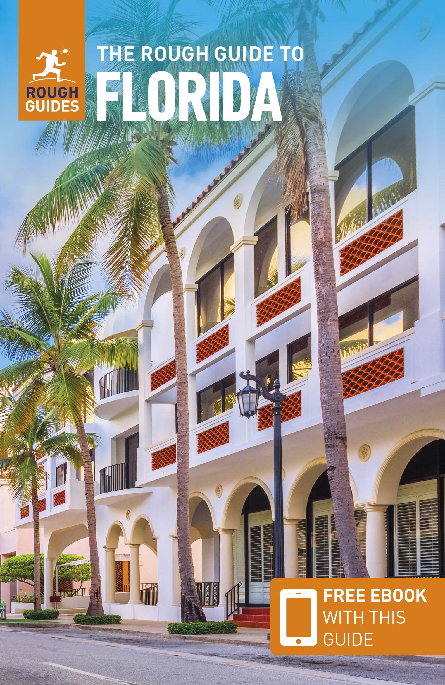
This practical travel guide to Florida features detailed factual travel tips and points-of-interest structured lists of all iconic must-see sights as well as some off-the-beaten-track treasures. Our itinerary suggestions and expert author picks of things to see and do will make it a perfect companion both, ahead of your trip and on the ground. This Florida guide book is packed full of details on how to get there and around, pre-departure information and top time-saving tips, including a visual list of things not to miss. Our colour-coded maps make Florida easier to navigate while you're there. This guide book to Florida has been fully updated post-COVID-19 and it comes with a free eBook.


The Rough Guide to FLORIDA covers: Miami, the Florida Keys, the Everglades, the southeast, Sarasota and the southwest, Orlando and Disney World, the northeast, Tampa Bay and the northwest and the Panhandle.


Inside this Florida travel guide you'll find:


RECOMMENDATIONS FOR EVERY TYPE OF TRAVELLER


Experiences selected for every kind of trip to Florida, from off-the-beaten-track adventures in Florida's northwest coast to family activities in child-friendly places, like Sanibel Island or chilled-out breaks in popular tourist areas, like the Florida Keys.


PRACTICAL TRAVEL TIPS


Essential pre-departure information including Florida entry requirements, getting around, health information, travelling with children, sports and outdoor activities, food and drink, festivals, culture and etiquette, shopping, tips for travellers with disabilities and more.


TIME-SAVING ITINERARIES


Includes carefully planned routes covering the best of Florida, which give a taste of the richness and diversity of the destination, and have been created for different time frames or types of trip.


DETAILED REGIONAL COVERAGE


Clear structure within each sightseeing chapter of this Florida travel guide includes regional highlights, brief history, detailed sights and places ordered geographically, recommended restaurants, hotels, bars, clubs and major shops or entertainment options.


INSIGHTS INTO GETTING AROUND LIKE A LOCAL


Tips on how to beat the crowds, save time and money and find the best local spots for sunbathing, kayaking or soaking up local history..


HIGHLIGHTS OF THINGS NOT TO MISS


Rough Guides' rundown of Orlando, Tallahassee, Tampa and Miami's best sights and top experiences helps to make the most of each trip to Florida, even in a short time.


HONEST AND INDEPENDENT REVIEWS


Written by Rough Guides' expert authors with a trademark blend of humour, honesty and expertise, this Florida guide book will help you find the best places, matching different needs.


BACKGROUND INFORMATION


Comprehensive 'Contexts' chapter of this travel guide to Florida features fascinating insights into Florida, with coverage of history, religion, ethnic groups, environment, wildlife and books, plus a handy language section and glossary.


FABULOUS FULL COLOUR PHOTOGRAPHY


Features inspirational colour photography, including the stunning South Beach and the spectacular Everglades.


COLOUR-CODED MAPPING


Practical full-colour maps, with clearly numbered, colour-coded keys for quick orientation in downtown Miami, downtown Jacksonville and many more locations in Florida, reduce the need to go online.


USER-FRIENDLY LAYOUT


With helpful icons, and organised by neighbourhood to help you pick the best spots to spend your time.


FREE EBOOK


Free eBook download with every purchase of this guide book to Florida allows you to access all of the content from your phone or tablet, for on-the-road exploration.


€ 23.95
Reisgids Colorado | Moon Travel Guides

Uitstekende Amerikaanse reisgids van uitgever Moon. De gids is vergelijkbaar met Lonely Planet en Rough guide en is voor de backpacker - zelfstandige reiziger geschreven; toch is deze door de grote mate van details en achtergronden geschikt voor alle reizigers! De gids onderscheidt zich door gedegen en uitgebreide achtergrondinformatie over bijvoorbeeld natuur en cultuur.

From hiking through red rock canyons and aspen forests to hitting the slopes, find your adventure with Moon Colorado. Inside you'll find:


- Strategic itineraries including a two-week road trip and quick getaways, with suggestions for outdoor adventurers, winter sports enthusiasts, history buffs, road-trippers, foodies, and more.

- The top activities and unique experiences: Explore ancient pueblos or Wild West ghost towns, soak in a steaming hot spring, and spot wild elk, horses, and foxes. Savour fresh flavours at a farm-to-table restaurant and kick back with some of Colorado's delicious local microbrews.

- Outdoor adventures: Go white-water rafting or kayaking on a rushing river, and hike slickrock trails to awe-inspiring views of snow-capped mountain peaks. Ski the deep powder of some of the country's top resorts and relax with a delicious après-ski drink.

- Full-colour photos and detailed maps throughout.

- Local insight from a lifelong adventurer Terri Cook on when to go, what to pack, and where to stay, from campsites and motels to B&Bs and resort lodges.

- Reliable background on the culture, weather, wildlife, and history, plus tips on getting there and getting around by car, train, and public transportation.

- Recommendations for families, LGBTQ+ travellers, seniors, international visitors, and travellers with disabilities.

- Full coverage of Denver, Boulder and the Northern Front Range, Rocky Mountain National Park, Steamboat Springs and Northwest Colorado, Vail and the Central Rockies, Aspen and the Roaring Fork Valley, Mesa Verde and the Southwest, Colorado Springs and the Southeast.


With Moon's practical tips and local insight, you can experience the best of Colorado.


Staying in the city? Try Moon Denver, Boulder & Colorado Springs. Staying in the park? Try Moon Rocky Mountain National Park. For an all-outdoors adventure, try Moon Colorado Camping.

About Moon Travel Guides: Moon was founded in 1973 to empower independent, active, and conscious travel. We prioritize local businesses, outdoor recreation, and traveling strategically and sustainably. Moon Travel Guides are written by local, expert authors with great stories to tell-and they can't wait to share their favourite places with you.

For more inspiration, follow @moonguides on social media.


€ 15.95
Wandelkaart - Topografische kaart 242 Avenches | Swisstopo

Deze kaart is onderdeel van de 1:50.000 serie van de topografische kaarten van de Zwitserse topografische dienst, die in 78 delen het hele land bestrijkt. Deze kaarten zijn beroemd en gewaardeerd om het geweldige kleurgebruik voor reliëf en hoogte door schaduwwerking. De kaarten geven bijna een 3D beeld van het landschap.


De hoogtelijnen kennen een interval van 20 meter. Wandelroutes en berghutten zijn zichtbaar, al moet je daar door de grote hoeveelheid informatie wel de nodige moeite voor doen. Ze hebben het overigens makkelijk gemaakt voor de gebruiker door voor bijna heel Zwitserland dezelfde kaart met ingetekende wandelroutes uit te brengen. Zie voor deze kaart bij de wandelkaarten Zwitserland.


Uiteraard geschikt voor GPS gebruik door duidelijke weergave van het Zwitserse coördinatensysteem.


Steden/dorpen/gebieden/bergen/dalen/rivieren/meren:

Neuchâtel / Neuenburg, Fribourg / Freiburg, Murten / Morat, Payerne, Tafers, Belfaux, Domdidier, Courtepin, Gurmels, Avenches, Estavayer-le-Lac, Bevaix, Cortaillod, Colombier, Boudry, Peseux, Cudrefin, Portalban, St-Aubin, Chevroux, Grolley, Düdingen, Laupen, Ins, Müntschemier, Mont Vully, Lac de Neuchâtel / Neuenburgersee, Lac de Morat / Murtensee, Schiffenensee / Lac de Schiffenen, Saanetal

€ 15.95
Wandelkaart - Topografische kaart 241 Val de Travers | Swisstopo

Deze kaart is onderdeel van de 1:50.000 serie van de topografische kaarten van de Zwitserse topografische dienst, die in 78 delen het hele land bestrijkt. Deze kaarten zijn beroemd en gewaardeerd om het geweldige kleurgebruik voor reliëf en hoogte door schaduwwerking. De kaarten geven bijna een 3D beeld van het landschap.


De hoogtelijnen kennen een interval van 20 meter. Wandelroutes en berghutten zijn zichtbaar, al moet je daar door de grote hoeveelheid informatie wel de nodige moeite voor doen. Ze hebben het overigens makkelijk gemaakt voor de gebruiker door voor bijna heel Zwitserland dezelfde kaart met ingetekende wandelroutes uit te brengen. Zie voor deze kaart bij de wandelkaarten Zwitserland.


Uiteraard geschikt voor GPS gebruik door duidelijke weergave van het Zwitserse coördinatensysteem.


Steden/dorpen/gebieden/bergen/dalen/rivieren/meren:

Pontarlier, Sainte Croix / Ste-Croix, Grandson, Yvonand, Fleurier, Couvet, St-Aubin-Sauges, Baulmes, Concise, Les Fourgs, Le Frambourg, Montbenoît, Les Gras, La Brévine, Travers, Noiraigue, Buttes, Les Verrières, La Côte-aux-Fées, Bullet, Villars-Burquin, Le Chasseron, Mont Aubert, Le Soliat, La Chaille, Aiguilles de Baulmes, Montagne du Larmont, Lac de Neuchâtel / Neuenburgersee, Lac des Taillères, Val de Travers, Vallon de Noirvaux, Vallée du Doubs / Doubstal

Abonneer op