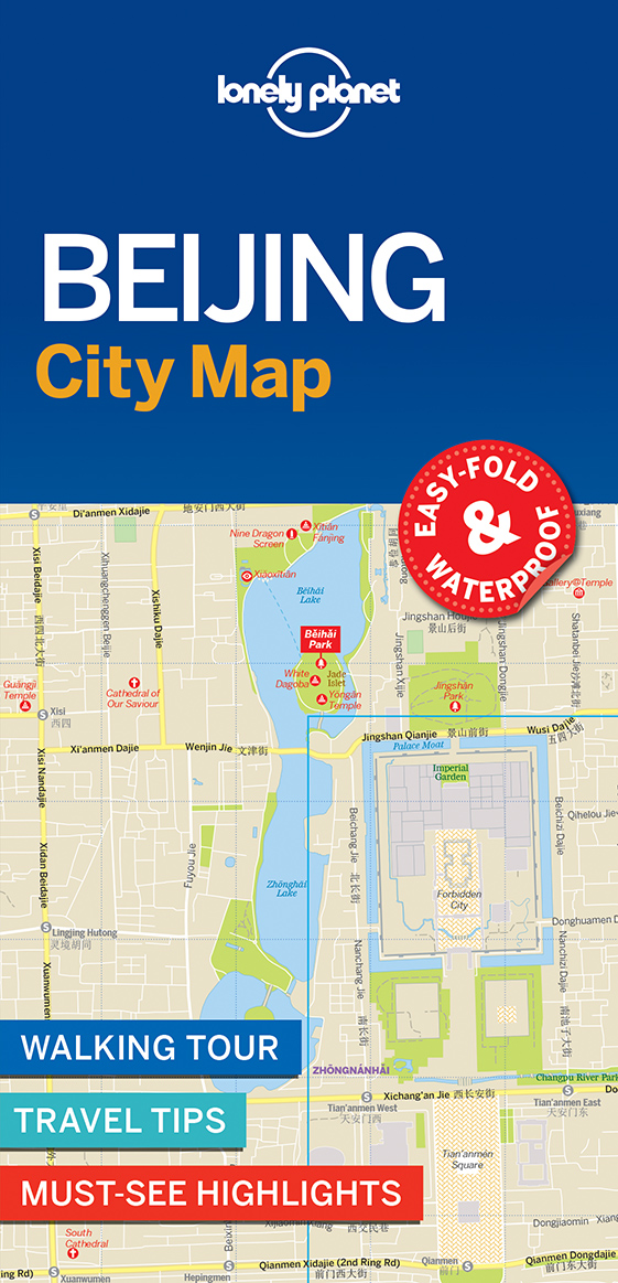
€ 17.50
Wegenkaart - landkaart 3315 Adventure Map Corsica | National Geographic

Wegenkaart van Corsica met vermelding van veel bezienswaardigheden, nationale parken en attrakties. Watervast en scheurvast. Juist door deze vermeldingen onderscheidt de kaart zich van andere wegenkaarten.

National Geographic's Corsica Adventure Map is designed to meet the unique needs of adventure travelers with its durability and accurate information. Each folded map provides global travelers with the perfect combination of detail and perspective, highlighting the area’s terrain and best locations for adventure activities like snorkeling, surfing, fishing, and more. Adventure Maps include hundreds of points of interest that highlight diverse and unique destinations within the country.


The map includes the locations of thousands of cities and towns with a user-friendly index, plus a clearly marked road network complete with distances and designations for major highways, main roads, and tracks and trails for those seeking to explore more remote regions. The front side of the Corsica map details the northern region of this island country; bordering Golfe de Sagone and Golfe de Porto to the west, Tyrrhenian Sea to the east, and the Ligurian Sea and Golfe de St.-Florent to the north. The reverse side of the map details the southern region; from its border with the Bouches de Bonifacio to the south, to the Tyrrhenian Sea, Golfe de Santa-Manza and Golfe de Porto-Vecchio to the east, and the Mediterranean Sea, Golfe de Sagone, Golfe de Valinco and Golfe d’ Ajaccio to the west. This island is located west of Italy, southeast of the French mainland and north of the Italian island of Sardinia. Adventure Maps are printed in the United States on a durable synthetic paper, making it waterproof, tear-resistant and tough—capable of withstanding the rigors of international travel.


Key Features:

Waterproof and tear-resistant

Detailed interpretive information and local travel tips

Detailed topography complete with activity symbols, ideal for exploring the country

City overview maps

Hundreds of points of interest, including the location of World Heritage sites, national parks and nature reserves, aboriginal settlements and protected lands, mines, archeological sites, wildlife parks and more

Thousands of place names

Important travel aids including airports, lighthouses, ferry routes and rail lines

Developed in cooperation with local agencies

Updated regularly to ensure accuracy


€ 11.50
Reisgids Marco Polo ENG Edinburgh | MairDumont

Handige en overzichtelijke, kleine reisgids voor een eerste kennismaking met de vakantiebestemming. Globale uitklapkaart achterin, makkelijk binnenzakformaat.

Experience all of Edinburgh’s attractions with this up-to-date, authoritative guide, complete with ‘Best Of’ recommendations. Discover boutique hotels, authentic restaurants, the city’s trendiest places and night spots, get tips on shopping and what to do on a tight budget, as well as plenty of ideas for travel with kids plus sports and a wide range of activities. Also contains: the Perfect Day, Festivals & Events, Travel Tips, Links, Blogs, Apps & more and a comprehensive index.

The Scottish capital has always been a prosperous place, vibrant and cosmopolitan without compromising its traditional Scottish heritage of kilts, bagpipes, folk music and whisky. It is divided into two distinct parts, the Old Town and New Town, which are both listed as UNESCO World Heritage Sites. While the Old Town is dominated by its massive, medieval castle, the New Town is the product of Georgian planning and design.


MARCO POLO Edinburgh takes you on a journey through time. The practical pocket-sized guide presents a small capital at the edge of Europe, but one that can easily compete with much larger destinations. Take a stroll through this city of international festivals, churches and cemeteries, monuments and museums, creepy stories and strange happenings.


The Insider Tips reveal where you can drink beer made of seaweed, where Edinburgh’s closest beach resort is situated and why the station clock is always two minutes ahead. The ‘Best Of’ pages show you things you can find only in Edinburgh, recommend places to go for free, things to do on a rainy day and how best to relax and unwind.


Find out What’s Hot in Edinburgh – whether art cafés, vintage second-hand shops or places to watch football in 3D. The City Walks chapter leads you through the city’s literary past as well as to the oldest pub in Scotland – dating from 1360. Finally, the Dos & Don’ts point out some of the things you need to be aware of and watch out for when visiting the city.


MARCO POLO Edinburgh provides comprehensive coverage of the city. To help you find your way around there’s a detailed street atlas inside, a useful public transport map in the backcover, plus a handy pull-out map.

€ 19.95
Wereldkaart 62P-zvlE Political, 68 x 45 cm | Maps International

Door het heldere en vrij felle kleurgebruik is deze kaart uitermate geschikt voor scholen, kantoren of gewoon als politieke wereldkaart thuis. Bedenk wel dat deze maat klein is om van ver af goed te kunnen lezen.De kleurstellig is zodanig dat elk land zich zeer goed onderscheidt van haar buren. De natuurkundige aspecten zijn minder goed te zien, al worden de gebergten door schaduwwerking goed uitgelicht. De nadruk ligt echter duidelijk op een ‘gewone’ wereldkaart. De belettering is uitstekend leesbaar door vetgedrukte naamgeving.


Engelstalig, maten: 68 x 45, geplastificeerd, zonder vlaggen. Dit is de enige goede kaart die op een deur past!


€ 18.50
Reisgids A Hedonist's Guide to Baku | Hg2

Once the richest oil city in the world, several decades of Soviet occupation left the capital of Azerbaijan leagues behind the competition. Now a new wave of oil money and development has fed Baku’s growth into one of the most excitingly developing cities on the globe. In this, the first English language guide to Baku in the world, Hg2 unveils a city on the up and straddling the true dividing line of East and West. Discover a richly diverse and cosmopolitan city, filled with Persian bazaars, Georgian gastronomy, Caucasian hospitality, stunning architecture, luxurious hotels and the UNESCO world heritage site walled old town. A short journey from Baku lie mud volcanoes, lush forests and desert plains rising into the glory of the Caucasus mountains, to say nothing of the photogenic marvel of the Caspian oil refineries. Where Europe collides with Asia and Persian roots have grown into European aspirations, Baku has developed into one of the world’s last true melting pots of ancient and modern, East and West.

€ 17.50
Wegenkaart - landkaart 3303 Adventure Map Ireland - Ierland | National Geographic

Wegenkaart van Ierland met vermelding van veel bezienswaardigheden, nationale parken en attrakties. Watervast en scheurvast. Juist door deze vermeldingen onderscheidt de kaart zich van andere wegenkaarten.

National Geographic's Ireland Adventure Map is designed to meet the unique needs of adventure travelers—detailed, durable, and accurate. Ireland includes the locations of thousands of major cities and towns with an index for easily locating them, plus a clearly marked road network complete with distances and designations for major highways, limited access highways and more.


What sets National Geographic Adventure Maps apart from traditional road maps are the hundreds of points-of-interest that highlight the diverse, unique, and exotic destinations within Ireland including national parks and preserves, World Heritage sites, castles, archeological sites, monuments, scenic viewpoints, beaches, natural points of interest, and important travel aids like airports, airstrips, rail lines, ferry routes, lighthouses, and harbors.


The north side of the Ireland map details from the northernmost tip of the island at Malin Head south to Dublin and Galway, including Belfast, Dundalk, Londonderry, and Sligo. The south side overlaps the northern side of the map at Galway on the west and Dublin on east, covering the remainder of the country including the cities of Limerick, Tralee, Cork, and Waterford. An inset map provides detail of the Skellig Islands. Sites of interest from prehistoric monuments and castles to churches and abbeys are noted making this map indispensable for the traveler seeking to explore Ireland’s rich history.


Popular places included on the map: Connemara Countryside, Cliffs of Moher, The Burren, Blarney Castle and the Blarney Stone, Lakes of Killarney, Giant’s Causeway, Hill of Tara, and Trim Castle.


€ 29.95
Wandelkaart 2571 Turkart Sigdal - Rollag | Nordeca

Uitstekende wandelkaart van een deel van Noorwegen. De Noren zelf gebruiken deze kaarten ook voor hun wandeltochten in de berggebieden. Afhankelijk van de moeilijkheidsgraad van het gebied voldoet een 1:25.000, 1:50.000 of 1:100.000 kaart. 

Alle noodzakelijke informatie vind je er op terug: bemande en onbemande hutten, campings, rivier-oversteken, wandelroutes en veelal ook langlaufroutes; daarnaast natuurlijk de topografische details als hoogtelijnen, soort landschap of wegennet. Met UTM grid.


De legenda is in het Noors en Engels, verdere informatie op de achterzijde van de kaart is in het Noors. De kaart wordt geleverd in een plastic hoesje.


Gebied: Blefjell og Vegglifjell, Krødsherad, Modum, Rollag, Nore og Uvdal, Tinn, Flesberg, Øvre Eiker, Notodden, Sigdal

Plaatsnamen op de kaart: Buskerud, Flesberg, Krøderen, Numedal, Prestfoss, Rollag, Simoa, Tinnsjå, Veggli, Åmot


€ 17.50
Wegenkaart - landkaart 3107 Adventure Map Puerto Rico | National Geographic

Wegenkaart van Puerto Rico met vermelding van veel bezienswaardigheden, nationale parken en attrakties. Watervast en scheurvast. Juist door deze vermeldingen onderscheidt de kaart zich van andere wegenkaarten.

Like all Adventure maps, Puerto Rico contains detailed topographic information, plus useful traveling tips, and regional information. Printed on the same waterproof, tear-resistant material as our Trails Illustrated maps—our adventure series maps will stand up to rigorous travel, and contain the navigation aids necessary for backcountry use with GPS or compass.

€ 16.55
Wandelkaart South Loch Ness Trail | Harvey Maps

Mooie, duidelijke kaart van de South Loch Ness Trail in Schotland. Geplastificeerd met veel extra informatie en uitsnedes van de route.


This map has been produced in association with Destination Loch Ness Ltd.


The South Loch Ness Trail is 28 miles long and is an exciting new trail for all types of users. The Trail of the Seven Lochs at South Loch Ness is 50 miles long and offers stunning views for walkers and riders alike.


This map is your essential piece of equipment. Although the route is waymarked it is never a good idea to walk in remote areas without a map and compass.

€ 25.95
Wandelkaart Shropshire Way | Harvey Maps

Mooie, duidelijke kaart van de Shropshire Way in het midden van Engeland. Geplastificeerd met veel extra informatie en uitsnedes van de route.


Shropshire Way, Shropshire Hills


Map of the Shropshire Way Shropshire Hills section.


Tough, light and 100% wateproof


Compact and light - the map itself weighs just 60gms - a third of the weight of a laminated map, and much less bulky. And you can fold or refold it time and again, or stuff it in your back pocket and it won't fall to pieces. Shows the routes in the southern (Shropshire Hills) section


Information on finding accommodation, camping, food. Directions to the start. Also Ranger Service contact numbers and enlargements of towns/villages showing facilities available and tips on weather and clothing


Detailed mapping, full legend. National Grid - can be used with GPS. 1:40,000 scale. Waterproof. Supplied in clear plastic pocket

€ 17.50
Wegenkaart - landkaart 3023 Adventure Map Japan | National Geographic

Wegenkaart van Japan met vermelding van veel bezienswaardigheden, nationale parken en attrakties. Watervast en scheurvast.

National Geographic's Japan Adventure Map is designed to meet the unique needs of adventure travelers with its durability and accurate information. Each folded map provides global travelers with the perfect combination of detail and perspective, highlighting the area’s terrain and best locations for adventure activities like snorkeling, surfing, fishing, and more. Adventure Maps include hundreds of points of interest that highlight diverse and unique destinations within the country.


The map includes the locations of thousands of cities and towns with a user-friendly index, plus a clearly marked road network complete with distances and designations for major highways, main roads, and tracks and trails for those seeking to explore more remote regions.


Key Features:

Waterproof and tear-resistant

Detailed interpretive information and local travel tips

Detailed topography complete with activity symbols, ideal for exploring the country

City overview maps

Hundreds of points of interest, including the location of World Heritage sites, national parks and nature reserves, aboriginal settlements and protected lands, mines, archeological sites, wildlife parks and more

Thousands of place names

Important travel aids including airports, lighthouses, ferry routes and rail lines

Developed in cooperation with local agencies

Updated regularly to ensure accuracy

Abonneer op