€ 15.50
Fietsgids Bikeline Radrunde Niederlande . Ronde van Nederland | Esterbauer

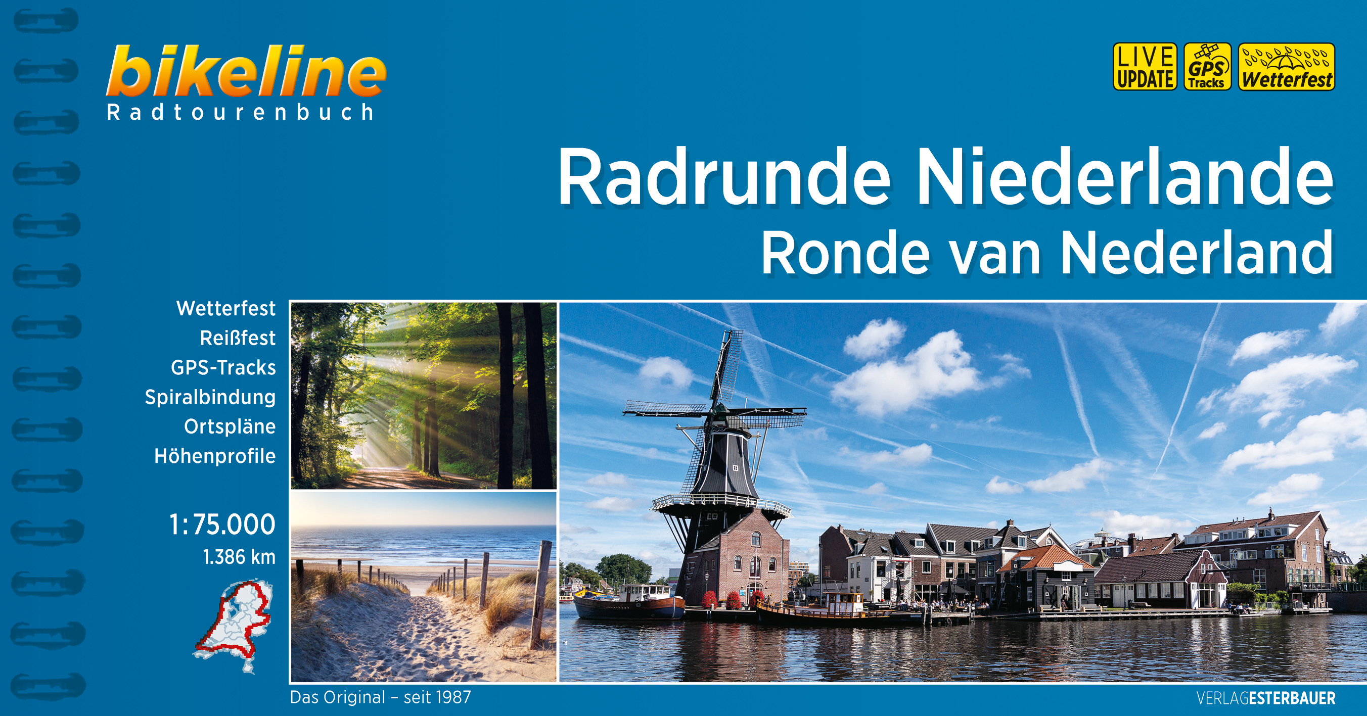
Praktische fietsgids met detailkaarten, ingetekende route, informatie over overnachten en fietsenmakers, zwaarte en hoogteprofiel. In spiraalbinding, Duitstalig, scheur- en watervast papier

Ronde van Nederland – auf dieser ausgedehnten Rundtour durch die Niederlande erfahren Sie, warum diese als das Land der Windmühlen, der Tulpen und des Käses gelten, vor allem aber als das Fahrradland schlechthin. Davon abgesehen werden Sie feststellen, dass die niederländischen Provinzen trotz der Flachheit des Landes eine erstaunliche Vielfalt verschiedener Landschaftsformen zu bieten haben und das Wasser in allen denkbaren Erscheinungsformen fast allgegenwärtig ist. Neben ausgedehnten Wäldern und weiten Heidelandschaften treffen Sie auf die einzigartige Welt der stets bewegten Dünen, auf urwüchsige Moore und stille Flussauen. Zwischendurch kommen Sie neben den zahlreichen Dörfern in schöner Regelmäßigkeit durch pittoreske und gemütliche Städtchen, die zum Innehalten einladen – sei es nun im Ortskern, einem schönen Park oder am Hafen. Zahlreiche Einkehrmöglichkeiten am Wegesrand verlocken zu ausgedehnten Pausen und zum Kennenlernen der niederländischen Küche.

€ 9.95
Stadsplattegrond City map Beijing - Peking | Lonely Planet

De stadsplattegronden van Lonely Planet zijn uitgevoerd op scheur- en watervast papier, zijn lichtgewicht en kennen een handig formaat. Het centrum van de stad is in heldere kleuren in beeld gebracht met straatnamen, bezienswaardigheden en symbolen voor openbaar vervoer. Op de achterzijde staat informatie over de toeristische hoogtepunten en in de meeste gevallen een schematische plattegrond van het openbaar vervoer. Met een register.

Durable and waterproof, with a handy slipcase and an easy-fold format, Lonely Planet Beijing City Map is your conveniently-sized passport to traveling with ease. Get more from your map and your trip with images and information about top city attractions, walking tour routes, transport maps, itinerary suggestions, extensive street and site index, and practical travel tips and directory. With this easy-to-use, full colour navigation tool in your back pocket, you can truly get to the heart of Beijing, so begin your journey now!

Durable and waterproof

Easy-fold format and convenient size

Handy slipcase

Full colour and easy-to-use

Extensive street and site index

Images and information about top city attractions

Handy transport maps

Walking tour routes

Practical travel tips and directory

Itinerary suggestions

Covers The Forbidden City, Dongcheng, Temple of Heaven Park, Beihai Park, Xicheng, Chaoyang, Haidian and more

Check out Lonely Planet Beijing, our most comprehensive guidebook to the city, covering the top sights and most authentic off-beat experiences. Or check out Lonely Planet Pocket Beijing, a handy-sized guide focused on the can't-miss experiences for a quick trip.


€ 12.50
Stadsplattegrond Plan de ville - Street Map Bruges - Brugge | Michelin

NEW. The Michelin Bruges City Map - part of Michelin's brand-new Laminated City Map series - is ideal for visitors wanting to see the sights and navigate around the city. Points of interest drawn from Michelin Green Guides are described and highlighted on the map for easy sight-seeing. Planned routes and stops can be marked, then wiped off the laminated surface* while the map's accordion-fold pattern allows for a fast look and even faster refold. Rely on Michelin's clear mapping and street index for an enjoyable visit. * Use only dry-erase markers.

€ 13.95
Wandelgids Peak Bagging | Vertebrate Publishing

Over fifty years ago, renowned British hillwalker and guidebook author Alfred Wainwright described 214 peaks in the English Lake District in his seven-volume illustrated Pictorial Guide to the Lakeland Fells. Like the Munros in Scotland, bagging all the Wainwrights has become a popular and significant challenge for walkers and runners, often taking many years in fits and starts because of the absence of a clear plan for how to link them together. With this problem in mind, Peak Bagging: Wainwrights by Karen and Dan Parker features forty-five routes designed to link up these iconic fells so you can enjoy the challenge of completing them at your own pace - over years, months or even just a few weeks.


It presents not only the most efficient routes for completing the Wainwrights as quickly as possible, but does so in such a way that each route is a fantastic walk or run in its own right. The featured routes include a round of the Scafells, and the Glenridding Horseshoe, taking in Helvellyn and Catstycam. The routes are split into seven sections, reflecting Wainwright's seven Pictorial Guides, and to simplify logistics, all of the featured routes are circular with an emphasis on making practical links between the summits.


In addition, the book is packed with useful information, including 1:40,000-scale maps, elevation profiles, public transport and parking details, refreshments, downloadable GPX files for each route and custom timings for walkers, trekkers, fastpackers and runners. Also included are overview details of Steve Birkinshaw's then-record-breaking sub-seven-day Wainwrights run in 2014 - current record holder Sabrina Verjee completed the round in under six days. Whatever your timescale for completing the 214 Wainwrights, Peak Bagging: Wainwrights is the indispensable guide to this British hill challenge.

€ 16.50
Wandelgids Big Trails Great Britain & Ireland Volume 2 | Vertebrate Publishing

Big Trails: Great Britain and Ireland Volume 2 is the second volume of this inspirational guide to the most iconic long-distance trails in England, Scotland, Wales, Ireland and the Channel Islands.


The twenty-five routes featured in this book comprise more of the best trails in Great Britain and Ireland. From some of Wales’ best views on the Pembrokeshire Coast Path and the magnificent moorlands of the Two Moors Way (Devon Coast to Coast) in South-West England, to Scotland’s wild moors on the Southern Upland Way and over high cliffs on Ireland’s Burren Way. In the shadows of Lakeland peaks on the Cumbria Way and around five islands on the Channel Island Way, the book incorporates the highlights of Great Britain and Ireland, from its centre to its outermost edges.


Big Trails books are designed to inspire big adventures. Rather than being carried along the route, this guide provides everything you need to plan and explore further, including a general overview of the trails, specific technical information, overview mapping, key information and stunning photography. As well as this, each route specifies approximate timings devised using the Jones–Ross formula, which allows for custom itineraries to be generated depending upon the speed of the user. Whether you’re walking, trekking, fastpacking or running, let Big Trails: Great Britain and Ireland Volume 2 be your guide.

€ 30.95
Wegenatlas IJsland met stadsplattegronden | Ferdakort

Super handige kleine wegenatlas van IJsland (schaal 1:500.000) met vooral een enorme hoeveelheid plattegronden van steden en dorpen, enkele themakaarten en een groot register. De kaarten zijn uitstekend leesbaar en de atlas in in een mooie ringband uitgevoerd. 

Road Atlas of Iceland at 1:500,000 from Ferðakort, published in a handy 15x25cm spiral-bound format, with an index of over 3,000 entries, a comprehensive distance table, 46 street plans including Reykjavik and several thematic map sincluding cultural heritage and geology.


The whole of Iceland is covered at 1:500,000 with the road network distinguishing between paved and gravel roads, and showing which small local roads are maintained by the country’s government. Fords, locations of petrol stations, driving distances and car ferry routes are marked. National parks and other protected areas are highlighted and symbols mark locations of various places of interest: different types of tourist accommodations including campsites, refuges and emergency shelters, museums and cultural centres, sport and recreational facilities, local airfields, hydro-electric and thermal power stations, etc. The maps have relief shading with spot heights and plenty of names of various geographical features. Lava fields and glaciers are shown and hot springs are prominently marked. The maps have latitude and longitude lines at intervals of 20’ and 30’ respectively. Comprehensive index of over 3,000 place names includes geographical features such as mountain ranges, volcanoes, etc.


The atlas includes street plans of 46 towns, highlighting places of interest and various facilities; Reykjavik is covered on 10 pages with an additional enlargement for the town centre. Also provided are a comprehensive distance table and several thematic maps: protected natural areas, historical heritage, orientation table for viewing the surrounding landscape, administrative divisions, radio reception areas, geology, and vegetation, etc. Map legend and all the text include English.

€ 219.95
Prikbord Europa Natuurkundig, 135 x 98 cm | Maps International

Maps International's large physical wall map of Europe is one of the finest money can buy.


European Map details: Our large physical wall map of Europe features the natural terrain of the land, with countries marked and international borders shown. The map's key helps to identify the land elevation and water depth. This large European physical wall map also contains city population detail, national capitals and all the major towns and cities in Europe.


Map uses: As with most of our maps, the large physical wall map of Europe, is available in a range of finishes making it suitable for a variety of locations. Major motorways and transport lines are shown on this European wall map making it an ideal map for planning and logistics


Prikbord

Prikbord, geplastificeerd met een glans folie, beschrijfbaar met drooguitwisbare stiten, omkaderd met een stijlvol aluminium designprofiel en afgewerkt met ronde, grijze kunststof hoekstukjes. Een pennengoot en standaard ophangmateriaal worden bijgeleverd.

€ 9.95
Kadotip Slaapmasker met Wereldkaart - licht blauw | Kikkerland

Ultrazacht slaapmasker met de opdruk van een wereldkaart lichtblauw . Het slaapmasker sluit al het licht buiten, waardoor er beter geslapen kan worden in een lichte kamer, in het vliegtuig of in de trein. De elastische band is verstelbaar en past bij iedereen.


All worldly travel dreams have to start somewhere!

The soft lining and adjustable elastic band of this sleep mask blocks out light to help you sleep better.

Made of 100% Polyester with cotton fiber fill.

Measurements: 20,6 x 10 x 0,6 cm

€ 39.95
Natuurgids - Reisgids Landschapsbiografie Van Westerwolde | van Gorcum

Westerwolde kent een grote variatie aan bijzondere cultuurlandschappen: van het unieke kloosterlandschap van Ter Apel in het zuiden, het nog zeer goed bewaard gebleven esdorpenlandschap langs de Ruiten Aa met zijn oude nederzettingen, essen, heidevelden en beekdalen, de historische verdedigingslinie rond Bourtange en Oudeschans tot aan de weidse veenontginningslandschappen bij Vriescheloo en Bellingwolde. Weinig streken in Noord-Nederland hebben zoveel bijzondere cultuurhistorische relicten en een zo rijk gelaagde geschiedenis met tal van bijzondere historische verhalen.

Door de verschillende grondsoorten heeft Westerwolde een sterk gevarieerde agrarische geschiedenis die tot op heden bepalend is voor het landelijk gebied. Ook de waterstaatkundige geschiedenis van Westerwolde heeft een eigen gezicht. Daarnaast is de streek ook rijk aan allerlei soorten natuur: in de beekdalen van Runde, Ruiten Aa, Mussel Aa en Westerwoldse Aa, in de bossen en heidevelden, maar ook in het boerenlandschap met zijn talrijke houtwallen, singels, akkerflora en bosjes. Juist de in eeuwen gegroeide intensieve verbinding tussen natuur en cultuur maken dit gebied zo belangrijk en veelzijdig.

De 'Landschapsbiografie van Westerwolde' is tegelijkertijd ook een biografie van mensen. Tientallen generaties bewoners, maar ook voorbijgangers en buitenstaanders, hebben het landschap in de loop der eeuwen gemaakt tot dat wat het nu is, en doen dat ook nu en in de toekomst. Om die reden wordt in deze biografie ook veel aandacht besteed aan hun leven, hun drijfveren, hun activiteiten en hun zichtbare sporen in het huidige landschap.

Dit is een wetenschappelijk verantwoord, toegankelijk geschreven verhaal over de ontstaansgeschiedenis, kwaliteiten en toekomstmogelijkheden van het landschap in deze regio. De biografie is rijk geïllustreerd met landschapsfoto's, kaarten en landschapsreconstructies die de verschillende levensfasen van Westerwolde weerspiegelen.

€ 13.99
Spel Openhartig Wereldwijd - Openhearted Worldwide | Open Up!

Met veel verschillende mensen delen wij de aarde. Maar hoe goed kennen wij elkaar nou eigenlijk echt? Openhartig Wereldwijd, het nieuwste spel van uitgever Open Up!, vergroot je kijk op culturen en daarmee ook je kijk op elkaar.


Deze editie met meer dan 100 vragen in 2 talen (Nederlands en

Engels), geeft jou en je medespelers nieuwe inzichten en perspectieven, begrip, grenzeloze openhartige gesprekken en bovenal veel plezier! Het biedt de kans elkaars culturele achtergrond én elkaar (nog) beter te leren kennen en te begrijpen. Om de beurt trekken jullie een kaart met een vraag of een opdracht zoals:

• Hoe ervaar je het land waar je nu bent én waar voel jij je echt thuis?

• Wat vind jij van de humor in het land waar jij nu bent?

• Is er sprake van vrijheid van meningsuiting in jouw land?

Hoe ervaar jij dit?

• Waar liggen jouw ‘roots’? En ‘wat’ daarvan draag jij nog

altijd bij je?

• Wat vind jij typische muziek uit jouw cultuur? Laat jouw medespelers hier iets van horen!

Speel Openhartig Wereldwijd en laat je verrassen én inspireren door jullie verschillende culturele achtergronden. Kennis over elkaars culturen zorgt er ook voor dat jullie elkaar beter begrijpen.


Dit spel is uitstekend geschikt als kennismakingsspel voor mensen met andere nationaliteiten of culturen, om mee te nemen op reis of om je buitenlandse collega’s of studiegenoten (nog) beter te leren kennen. Daarnaast blijft het ook verrassend leuk om dit spel te spelen met mensen uit je eigen cultuur. Iedereen beleeft een cultuur immers ook op een eigen manier, afhankelijk van bijvoorbeeld achtergrond of persoonlijke ervaringen.


--


We share the earth with lots of different people. But how well do we know each other? Where are your and the other person's roots? How do you feel about the country where you are now, and where do you really feel at home? This eition - with over 100 questions - offers you the chance to get to know each other and better understand each other's cultural background.

Abonneer op