€ 18.95
Wandelgids 8401 Tours dans le Luberon et les Monts de Vaucluse. | FFRP

6 boucles de 2 à 6 jours pour arpenter ce Géoparc mais surtout appricier les deux Luberon et les Mont-du Vaucluse.

Le PNR du Luberon offre une grande diversités de paysages à l'image du plateau des claparèdes et ses champs de lavande, vignobles et arbres truffiers ou encore l'Archipel des Ocres. Aussi appelé le colorado provencal, il n'a rien à envier à son homologue américain.


6 boucles de 2 à 6 jours pour arpenter ce Géoparc mais surtout appricier les deux Luberon et les Mont-du Vaucluse.


Des gorges d'Oppedette aux rives de la Durance, les Monts du Vaucluse et le massif du luberon se dévoilent grâce à six boucles rayonnat autour de la vilel d'Apt, cité au riche patrimoine historique et gastronomique.

€ 26.50
Campinggids You Are Here - Camping | Chronicle Books

This beautifully curated collection of amazing camping spots all around the world evokes awe-inspiring, attainable travel adventures.

Whether you're planning a getaway or just want to visit some of the world's most inspirational outdoor destinations from the comfort of your couch, You Are Here: Camping is the perfect wanderlust guide.

Pairing gorgeous photography with caption and geolocation information, the incredible handpicked locations will inspire anyone looking for their next journey.

* YOU ARE THERE--OR COULD BE!: Stunning photography will excite the spirit of adventure. Caption and geolocation information invite you to visit these gorgeous destinations.
* WIDE RANGE OF CAMPING DESTINATIONS: From idyllic streamside clearings to mindblowing mountain vistas, snowy scenic sites to cool forest hideaway spots, the handpicked locations offer an inspiring variety of places and journeys--pick your adventure.
* ARMCHAIR OR OUT THERE: A gorgeous collection equally suitable for kicking off your next immersive outdoor experience or capturing the beauty of nature to enjoy from the comforts of home.
* INSPIRING PHOTOGRAPHY: The beautiful photographs collected here will not just inspire travel, but inspire capturing and sharing photos of your own journey, to these or other amazing places.

€ 29.99
Vogelgids De gewiekste vogelgids | Kosmos Uitgevers

In 'De gewiekste vogelgids' presenteert Nico de Haan een uniek nieuw systeem om vogels te herkennen. De indeling op kleur, vorm, leefgebied, gedrag en geluid maakt dat het veel gemakkelijker wordt om een vogel te herkennen en de juiste naam bij de juiste vogel te vinden. Met zijn jarenlange ervaring met het geven van vogelcursussen voor de Vogelbescherming als uitgangspunt, heeft De Haan de perfecte methode gecreëerd om beginnende vogelaars op weg te helpen. Een onmisbare gids voor iedereen die op een eenvoudige manier vogels wil leren herkennen. Met prachtige illustraties van vogel- en natuurschilder Elwin van der Kolk. Bron: Flaptekst, uitgeversinformatie.

€ 14.95
Fietskaart BEL1 ADFC Radtourenkarte Vlaanderen - Flandern - België | BVA BikeMedia

Prachtige, heel goed leesbare fietskaart van Vlaanderen met alle LF routes en knooppunten. Duits en Nederlands. Als je een langere - meerdaagse - tocht gaat maken in België is dit echt een heel goede kaart: een absolute aanrader. De kaart van Vlaanderen loopt tot aan de lijn Maasstricht - Lille - Boulogne sur Mer, deze plaatsen staan er aan de onderzijde nog net op. 


Speciaal voor fietsers gemaakte kaart, waarbij juist de autowegen minder duidelijk te lezen zijn, maar waar de fietspaden gekleurd staan weergegeven. De kleur varieert naarmate de weg beter als fietsroute geschikt is. Lange afstands fietsroutes staan ingetekend, alsmede fietsenmakers, campings en interessante toeristische bezienswaardigheden. 


Informatie van de uitgever

komplett überarbeitete Neuauflage mit neuer Kartographie!

Offizielle Karte des ADFC Allgemeiner Deutscher Fahrrad-Club e.V. - die ideale Karte für Planung und Durchführung von großen Radtouren. Auf einem großen Gebiet von 130 x 160 Kilometern findet sich alles, was Radler brauchen – Routen, Sehenswürdigkeiten, Freizeitinformationen und vieles mehr. Optimale Orientierung * übersichtlich gestaltet * einfach zu handhaben * alle Radfernwege und regionale Radtouren * Anschlusskarten für ganz Deutschland und viele Nachbarländer * wetterfestes und reißfestes Papier * zusätzliche kostenfreie Online-Angebote: Download der gpx-Tracks der beschilderten Radrouten auf unserer website oder in unserer ADFC-Karten-App.


€ 23.99
Wandelgids Back to Nature | Spectrum

Wandelen in Nederland – terug naar de natuur!

In Back to nature nemen Eva en Nicola je mee op avontuur in de Nederlandse natuur. Waarom? Omdat wandelen in Nederland niet alleen verschrikkelijk mooi is, maar ook heel goed voor je. In dit boek hebben ze voor jou de mooiste wandelingen op een rij gezet, met bijbehorende activiteiten en een stukje persoonlijke ontwikkeling. Denk bijvoorbeeld aan het plukken van je eigen rucola of duindoornbessen en voor de diehards: winterkamperen of een duik in de koude zee! Weg van je scherm en terug naar de natuur.


In 2019 kreeg Eva Spigt onverklaarbare gezondheidsklachten en liep ze helemaal vast. Om een beetje te ontspannen begon ze samen met haar vriendin en hardcorewandelaar Nicola Dow, lange wandelingen door Nederland te maken. De natuur heeft van kleins af aan een belangrijke rol gespeeld in het leven van Nicola. Urenlang wandelen door bos en duinen is voor haar een manier om te vertragen, te verstillen en zich te laten verwonderen. Eva knapte onwijs op van deze wekelijkse wandelingen en zo ontstond ook het idee om samen het platform Backtonaturehikes te starten.


Inmiddels organiseren Eva en Nicola goedbezochte wandelingen, retreats en events om mensen op een laagdrempelige manier weer terug naar de natuur te brengen.


Nicola Dow werd op haar veertiende ernstig ziek door de ziekte van Crohn. Door haar levensstijl compleet om te gooien, te focussen op gezonde voeding, balans in body & mind, heeft ze de ziekte van Crohn op een natuurlijke manier overwonnen. In het dagelijks leven is Nicola een internationaal model en afgestudeerd natuurgeneeskundige. Ze gelooft sterk in de verbinding tussen lichaam en geest. Ze wil mensen enthousiasmeren om het prachtige Nederlandse landschap te ontdekken én bewust te worden van de invloedrijke kracht van de natuur op lichaam en geest.


Eva Spigt reisde de hele wereld rond maar bij terugkomst in Nederland werd ze (onverklaarbaar) ziek. Wandelen in de natuur hielp haar er weer bovenop. Met een achtergrond in pr, copywriting, sport en evenementen, kwam al snel het idee om met andere mensen te gaan wandelen. Door haar leeftijdsgenoten wordt wandelen vaak als suf gezien. Haar missie is dan ook om wandelen weer hip te maken.

€ 34.95
Reisinspiratieboek Bike Rides of Australia and New Zealand 1 | Lonely Planet

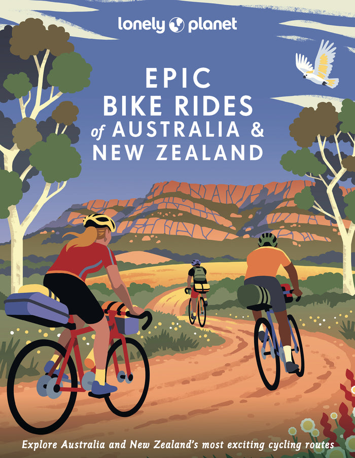
Hit the road with this collection of 200 epic bike rides across Australia and New Zealand. Cycle along Tasmania's Bay of Fires Trail or pedal through the South Island's misty native forest on the Old Ghost Road. Featuring 50 first-person stories and a further 150 ideas for similar trips, you'll find inspiration for a lifetime of biking adventures.

Loop around Lake Burley Griffin for the ultimate tour of Canberra's arts and culture scene; descend through the gum forests of the Blue Mountains and discover the natural wonder of Sydney's backyard; explore the reclaimed Timber Trail in rural Waikato on the North Island; or enjoy a diverse and enchanting excursion along the South Island's Heaphy Track. Whether you're a seasoned cyclist or you're looking to embark on your first bikepacking holiday, you'll find expert tips and practical information including when to go and where to stay, to help make planning your trip a total breeze.


Inside Epic Bike Rides of Australia and New Zealand:

- Discover 50 first-person stories, plus a further 150 inspirational ideas for unforgettable bike rides in Australia and New Zealand

- Expert toolkit with travel knowledge and advice to help you get there including the best time to go, gear required, nearest town, where to stay, opening hours, suggestions for similar trips, and more

- Challenge level grading for each bike ride - easy, harder, epic - to determine the trails you wish to tackle

- Breathtaking photography of each destination's vast and impressive landscape. Plus illustrated maps of the core cycling trails

- Beautiful and vibrant book cover by New Zealand illustrator, Ross Murray

- Covers circuits, trails, loops and routes in: Australian Capital Territory, New South Wales & Queensland; Northern Territory, South Australia & Western Australia; Tasmania & Victoria; North Island, New Zealand; South Island, New Zealand


Epic Bikes Rides of Australia and New Zealand is the ultimate travel inspiration for anyone dreaming of their next two-wheeled trip. This stunning book continues the collectible Lonely Planet Epic series and is a thrilling follow-up to Epic Bike Rides of the World. Gift this impressive compendium to the cycling lover in your life or to a friend who is looking to experience a sustainable travel adventure in the near future.


About Lonely Planet

Lonely Planet, a Red Ventures Company, is the world's number one travel guidebook brand. Providing both inspiring and trustworthy information for every kind of traveller since 1973, Lonely Planet reaches hundreds of millions of travellers each year online and in print and helps them unlock amazing experiences. Visit us at lonelyplanet.com and join our community of followers on Facebook (facebook.com/lonelyplanet), Twitter (@lonelyplanet), Instagram (instagram.com/lonelyplanet), and TikTok (@lonelyplanet).


'Lonely Planet. It's on everyone's bookshelves; it's in every traveller's hands. It's on mobile phones. It's on the Internet. It's everywhere, and it's telling entire generations of people how to travel the world.' - Fairfax Media (Australia)

€ 23.50
Wandelgids The North Western Fells | Lake district | Frances Lincoln

One name above all others has become associated with walking in the Lake District: A. Wainwright, whose seven-volume Pictorial Guide to the Lakeland Fells, first published in 1955–66, has become the definitive guidebook. Wainwright’s meticulously hand-drawn maps, diagrams and drawings take you up the 214 principal hills and mountains of the Lake District, describing the main routes of ascent from different starting points, as well as lesser-known variants, showing the summit viewpoint panoramas and the ridge routes that can be made to create longer walks. The North Western Fells, Book Six of Wainwright’s Walking Guide, covers the area between the rivers Derwent and Cocker, bordered by Crummock Water and Buttermere to the west and by Bassenthwaite Lake and Derwent Water to the east.  

€ 23.50
Wandelgids The Far Eastern Fells | Lake District | Frances Lincoln

One name above all others has become associated with walking in the Lake District: Alfred Wainwright, whose seven-volume Pictorial Guide to the Lakeland Fells, first published in 1955–66, has become the definitive guidebook. 


Wainwright’s meticulously hand-drawn maps, diagrams and drawings take walkers up the 214 principal hills and mountains of the Lake District, describing the main routes of ascent from different starting points, as well as lesser-known variants, showing the summit viewpoint panoramas and the ridge routes that can be made to create longer walks. Every page combines words and illustrations to present the routes in a way that is original, visually appealing and easy to follow.


This new edition of Wainwright’s Walking Guide to the Lake District Fells has been comprehensively revised. Paths, maps, diagrams and route descriptions have been checked and corrected throughout. These revisions have been undertaken by writer and designer Clive Hutchby, author of The Wainwright Companion.


The Central Fells, Book Three of Wainwright’s Walking Guide, covers the popular fells accessible from Great Langdale, Ambleside, Grasmere, Keswick and Borrowdale, including Harrison Stickle, Pike o’Stickle, Pavey Ark, Silver How Loughrigg Fell, Helm Crag and Walla Crag.

€ 13.95
Wandelkaart - Fietskaart 08 Baraque de Fraiture Lierneux Manhay Dochamps | Mini-Ardenne

Wandelkaart Baraque de Fraiture - Mini Ardenne


Productomschrijving: De mini-ardenne is een handige overzichtelijke wandelkaart op schaal 1/25.000 van een deel van de Ardennen, namellijk:


Burg-Reuland, Crombach, Ouren, Sankt-Vith, Schneifel en Weiswampach.


Door het gebruik van knooppunten en kleine en grote lus-vormige wandelingen zijn deze kaarten geschikt voor zowel beginnende als geoefende wandelaars, fietsers en ruiters. Ook de toeristische bezienswaardigheden, campingplaatsen en interessante locaties zoals eetgelegenheden, speelpleinen,... worden weergegeven.


- Reliëf en hoogtelijnen met een interval van 5 meter

- Afstand in kilometer bij elke sectie (tussen twee knooppunten) om de totale lengte van de route te berekenen

- Legende en teksten zijn viertalig (Nederlands, Frans, Engels en Duits)

- Bevat QR codes die linken naar de website: www.mini-ardenne.be waarop alle bezienswaardigheden in de desbetreffende stad worden weergeven.

Abonneer op