€ 14.95
Wandelkaart North Cotswold Classic Walks | Goldeneye

With 10 circular, clearly-marked routes this easy-to-use map will help you discover the Cotswolds via some of the finest pubs and tearooms.


Step into the Cotswolds with these exceptionally beautiful walks. Discover idyllic honey-coloured stone villages, quintessentially English market towns and spectacular views as you explore the quiet trails in and away from the tourist hotspots.


Each of the 10 walking tours include:

All the practical information you need how far, how much time to allow, what's the terrain like, is it suitable for dogs, where are the loos, where do I park, can I get a cream tea or a beer along the way

Features of interest each map includes the highlights of what you can expect to see along the way

Clear navigational reference points at each turn there is a clear description of what you should be able to see to ensure you select the correct route


With the walks starting from 4 miles, there s a walk for everyone here. Use the short description and photographs to help you decide whether the route suits you then strap on your boots and head out for a wonderful escape into the Cotswolds countryside.

€ 16.50
Fietskaart Reivers Cycle Routes | Northern Heritage Services

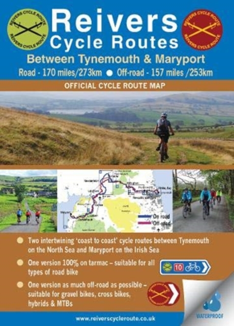
The long-distance Reivers Cycle Routes are two intertwining signed / waymarked bi-directional ‘coast to coast’ cycle routes between the North Sea and the Irish Sea.


The original Reivers Cycle Route was created in 1998 eventually becoming NCN Route 10 with interlinking on-road and off-road sections but this soon morphed into a one-size-fits-all route which never worked well. The regenerated re-launched Reivers Cycle Routes are two intertwining route options – one which is as much off-road as possible suitable for gravel and cross bikes, hybrids and mountain bikes and a version designed for capable road cyclists 100% on tarmac.


The routes are bi-directional and continuously reward the rider with beautiful views of the constantly changing terrain, provide many places of interest to pass by or call in and many lovely villages and quiet hamlets to cycle through or stay the night. Most importantly, there is a supply of excellent on route or close-to-route refreshments stops.


The off-road version is waymarked with mulberry coloured waymarks, and the on-road route is signed using standard blue coloured cycle route signs. Some sections may no longer have or have ever been, allocated NCN status and those sections are signed and or waymarked without a red 10.


The Reivers Cycle Routes logo is a lime green coloured roundel detailing two crossed swords being a weapon favoured by the original Reivers. This logo brands the route and appears on all road signs. The same logo but mulberry coloured signifies and characterises the off-road alignment of the Reivers Cycle Route.


En route it is possible to: experience iconic landmarks beginning / ending at Tynemouth with its many historic connections, sandy cove, twin piers, castle and priory; ride through hidden parts of Northumberland rich with heritage; traverse Scandinavian-like Kielder Water and Forest Park; cross the line of Hadrian’s Wall; ride via Carlisle Castle and Tullie House Museum; take in little known corners of Northumberland National Park and enjoy the northern fringe of the Lake District National Park arriving at, or departing from, Maryport harbour on West Cumbria’s World Heritage Site coastline.


Reivers Off-road Adventure Cycle Route


The Reivers Off-road Adventure Route is a new style of waymarked long-distance cycle route which requires a higher level of self-sufficiency than traditional road-based cycle routes. This route is a ‘coast to coast’ journey as off-road as possible encompassing an incredible variety of landscapes in a truly imaginative way by utilising miles of excellent off-road tracks of real quality.


Reivers On-road Challenge Cycle Route


The Reivers On-road Challenge Cycle Route will provide an opportunity for road cyclists to safely and enjoyably cycle a scenic ‘coast to coast’ route which is 100% on-road passing through remote locations. This route version optionally starts/ends at Ponteland although starting/ending at Tynemouth remains an option.


The Reivers Adventure / Challenge Cycle Routes will appeal to a variety of touring cyclists looking for an achievable challenge and an opportunity to safely ride a ‘coast to coast’ route which is either as much off-road as possible or is entirely on-road.


Undoubtedly, both route options truly are challenging journeys of discovery, comprising many miles that are ‘off the beaten track’ waiting to be explored. Do plan to ride your preferred route type across this beautiful and often remote part of Northern England.

€ 17.95
Fietskaart Costa Blanca North | Active Maps Limited

A 100,000 scale detailed road cycle map for North Costa Blanca (the coastal zone and mountains around Denia, Xabia/Javea, Moraira, Calpe, Altea & Benidorm). Easy cycle route planning with road classifications, distance markers between key junctions, top climbs, spot heights and relief representation. Includes 11 classic route suggestions that pass through valleys, go high up into the mountains, visit unspoilt villages and towns and meander along the coast.


Features over 60 top climbs marked on the map with details of gradient, ascent and length (Coll de Rates, Port de Tudons, Confrides, Cumbre del Sol, Port de Bernia, Miserat, Vall d'Ebo, Coll de la Garga, and many more). Some of the key inland towns on the map include Tarbena, Castell de Castells, Xalo/Jalon, Pego, Villalonga, Sella, Guadalest, L'Orxa, Benifallim, Planes, Muro de Alcoy). The map is printed on tough and waterproof paper.

€ 24.50
Reisgids PassePartout Aruba | Edicola

‘O, Aruba, dushi tera!’ luidt het Arubaanse volkslied. En een prachtig eiland is het. Witte zandstranden, strakblauwe baaien waar je het hele jaar door kan zwemmen, kalksteengrotten en glooiende heuvels. Aan de oostkant is het 3.200 hectare grote Arikok National Park. Ook de andere natuurparken, de mangrovebossen, de grotten en goudmijnen zijn het bezoeken zeker waard. De flora en fauna is uniek en de onderwaterwereld is overweldigend en mooi. Op het Caribische eiland kun je heerlijk chillen op de stranden, cultuur snuiven in Oranjestad en San Nicolas en genieten van alle culinaire hotspots. Je kan er wandelen, fietsen en (water)sporten, een kijkje nemen in de musea en shoppen. Kortom: oneindig veel mogelijkheden voor een onvergetelijke vakantie. Auto-, fietsroutes en wandelingen leiden je over dit eiland.


Ellen De Vriend is thrillerschrijfster, freelance (reis)journalist en fotografe  en al tientallen keren op Aruba geweest. Ze houdt niet van gebaande wegen en bezoekt ook juist de minder bekende locaties en laat bij voorkeur de onbekende rijkdommen van dit kleurrijke eiland zien.

€ 21.50
Wandelgids Martinusroute | Grote Routepaden

Uitstekende wandeligds van de Martinus route in België : De Martinusroute loopt van het Nederlandse Utrecht of Groningen naar het Franse Tours. Deze wandelgids neemt je mee op een 450 km lange tocht door Vlaanderen, van Bergen op Zoom via Antwerpen, Beveren, Mechelen, Gent en Ieper naar Menen.

De kaarten - zeer helder afgebeeld - zijn van een schaal van 1:25.000 en soms in stedelijke gebieden nog wat gedetailleerder. 

€ 19.90
Wandelkaart - Wandelgids Parc Naturel del Cadi - Moixero | Editorial Alpina

Kaartenset van 2 wandelkaarten


Zeer gedetailleerde wandelkaart van een klein gebied. Met ingetekende wandelroutes en andere informatie. Spaanstalig, maar uitstekende kaart. Coordinaten zijn weergegeven, dus GPS compatible met UTM grid. 


Op de topografische wandelkaart worden o.a. berghutten, campings aangeduid en hoogtelijnen, ingetekende wandelroutes en de GR paden (doorgaande langeafstandswandelpaden). 


€ 22.95
Wandelgids Kompass Jouw Ogenblik Zuid-Tirol | 62Damrak

Deze beetje glossy wandelgids beschrijft 30 wandeltochten, ingedeeld naar gemakkelijk, gemiddeld en zwaar. De nadruk ligt op gemakkelijk, wat meestal wandelingen zijn van ongeveer 3 uur zonder enorme hoogteverschillen. Het zijn goede wandelingen voor de beginnende of minder ambitieuze wandelaar die wel op deze manier het gebied wil leren kennen. De foto's geven het geheel een 'lekker' sausje waar je wel enthousiast van wordt. Naast een goede beschrijving van de wandeltocht met hoogteprofiel en wat andere praktische informatie is elke wandeling voorzien van een kaartfragment met schaal 1:50.000


De Kompass-serie ‘Jouw Ogenblik’ combineert voor het eerst wandelgids en fotoboek: adembenemende foto’s en gedetailleerde routebeschrijvingen in Kompass-kwaliteit. Dit is hoe dromen herinneringen worden, en verlangens momenten die je nooit meer vergeet! Ontdek de vele geheimen van deze regio op 30 verrassende, fascinerende wandelroutes, waarbij jouw ogenblik al begint als je nog zit te dromen op de bank. Trek je schoenen aan, pak je rugzak in en neem je camera mee – want je tijd is wat je er zelf van maakt! Alle routes zijn ook in GPX te downloaden van de Kompass-website.

€ 22.95
Wandelgids Kompass Jouw Ogenblik Zwarte Woud | 62Damrak

Deze beetje glossy wandelgids beschrijft 30 wandeltochten, ingedeeld naar gemakkelijk, gemiddeld en zwaar. De nadruk ligt op gemakkelijk, wat meestal wandelingen zijn van ongeveer 3 uur zonder enorme hoogteverschillen. Het zijn goede wandelingen voor de beginnende of minder ambitieuze wandelaar die wel op deze manier het gebied wil leren kennen. De foto's geven het geheel een 'lekker' sausje waar je wel enthousiast van wordt. Naast een goede beschrijving van de wandeltocht met hoogteprofiel en wat andere praktische informatie is elke wandeling voorzien van een kaartfragment met schaal 1:50.000

De Kompass-serie ‘Jouw Ogenblik’ combineert voor het eerst wandelgids en fotoboek: adembenemende foto’s en gedetailleerde routebeschrijvingen in Kompass-kwaliteit. Dit is hoe dromen herinneringen worden, en verlangens momenten die je nooit meer vergeet! Ontdek de vele geheimen van deze regio op 30 verrassende, fascinerende wandelroutes, waarbij jouw ogenblik al begint als je nog zit te dromen op de bank. Trek je schoenen aan, pak je rugzak in en neem je camera mee – want je tijd is wat je er zelf van maakt! Alle routes zijn ook in GPX te downloaden van de Kompass-website.

€ 8.95
Wandelkaart 137 Tenneville | NGI - Nationaal Geografisch Instituut

Goede wandelkaart op basis van een topografische ondergrond. Deze toeristische wandelkaart is speciaal gemaakt met de plaats ongeveer in het midden en is daardoor uitstekend te gebruiken voor iedereen die de plaats of directe omgeving als uitvalsbasis heeft. Op de kaart zijn wandelroutes ingetekend, vaak met begeleidende tekst op de achterzijde. Ook bezienswaardigheden worden met symbolen aangeduid. 

wandelroutes, GR-routes, mountainbike routes, bezienswaardigheden, kaart en/of info op voor- en achterkant

Champion, Erneuville, Journal, Laneuville-au-Bois, Mochamps, Ortheuville, Tenneville, Wyompont.

Abonneer op