€ 25.50
Wandelkaart North Downs Way | Harvey Maps

Mooie, duidelijke kaart van de North Downs Way in Engeland. Geplastificeerd met veel extra informatie en uitsnedes van de route. 


XT40 - Leap forward in technical excellence. Tough, light and 100% waterproof


Compact and light - the map itself weighs just 60gms - a third of the weight of a laminated map, and much less bulky. And you can fold or refold it time and again, or stuff it in your back pocket and it won't fall to pieces.


Revised edition and format

Shows the entire route on one XT40 map sheet.


The Way is 246km (156 miles). This map covers the whole route from Farnham in the west to Dover on the south east coast.


Information on finding accommodation, camping, food. Directions to the start and end points. Shows facilities available and includes tips on weather and clothing.


Detailed mapping, full legend. National Grid - can be used with GPS. 1:40,000 scale. Waterproof. Supplied in clear plastic pocket.

€ 17.95
Wandelgids D081 Le Tarn a Pied | FFRP

Franstalige wandelgids van het prachtige gebied de Tarn. 52 wandelingen van verschillend niveau en lengte. De kaarten die zijn gebruikt in deze gids zijn stafkaarten met een schaal van 1:25.000, ideaal om op te lopen. De route staat er duidelijk in gemarkeerd.  U krijgt er een losse woordenlijst bij, met daarop de veelvoorkomende wandelwoorden vertaald van het Frans naar het Nederlands.

52 circuits de randonnée à travers le Tarn entre Albi, Castres et Mazamet, vignobles, chênaies et Monts de Lacaune.

Trait d'union entre Massif Central et Midi Toulousain, le Tarn, appuyé sur ses contreforts montagneux, est par essence une terre de rencontre. Ses chemins ondulent de collines en montagnes, côtoient profondes forêts, campagnes lumineuses, causses rocailleux et plateaux herbagers, s'attardent au bord des rivières et des lacs. Ici, quelques kilomètres suffisent pour changer d'univers : vignoble gaillacois, landes du Lacaunais, rocs du Sidobre, hêtraies de la Montagne noire constituent un assemblage subtil de petits pays.


Ce mélange est propice au développement d'un patrimoine biologique d'une grande valeur : chênes kermes, genévriers, orchidées, mais aussi pic mar, faucon pèlerin, hibou grand-duc, cincle plongeur... L'histoire du département est présente à chaque pas, ancienne comme celle des cathares ou plus récente comme celle des mineurs de Carmaux et de Jean Jaurès.

€ 33.95
Wandelgids - Klimgids - Klettersteiggids The Pyrenees | Cicerone

Prachtige en volledige wandel- en klimgids van de Hoge Pyreneën in Frankrijk, Andorra en Spanje. Per deelgebied worden m.b.v. duidelijke kaartjes en route informatie de verschillende tochten beschreven. Geschikt voor iedere bergwandelaar. Er is informatie over accomodatie in opgenomen, evenals allerlei praktische en gebiedsinformatie.

First in a new series of mountain guides by Cicerone Press, this illustrated book covers the high Pyrenees from the Cirque de Lescun in the west to the Carlit massif and Cerdagne east of Andorra. With introductory chapters on the region, detailed descriptions of long-distance routes and treks, and plenty of prectical travel detail.

An extensive introduction gives all the practical advice and information needed for planning a trip. It offers a background to the mountains and their exploration, and provides a snapshot of the range with sections that help the reader focus on specific areas of activity, and suggests where best to exercise that activity. It also lists all the Pyrenean 3000m summits and their location.

€ 19.50
Wandelgids Naxos and the Small Cyclades | Graf editions

Handig klein formaat engelstalige wandelgids Naxos, Donoussa, Iraklia, Koufonissia, Schinoussa bij elke uitgebreid beschreven dagwandeltocht is een gedetailleerde routekaart afgebeeld en foto's ter orientering van de moeilijke, verwarrende trajecten:

Van de uitgever

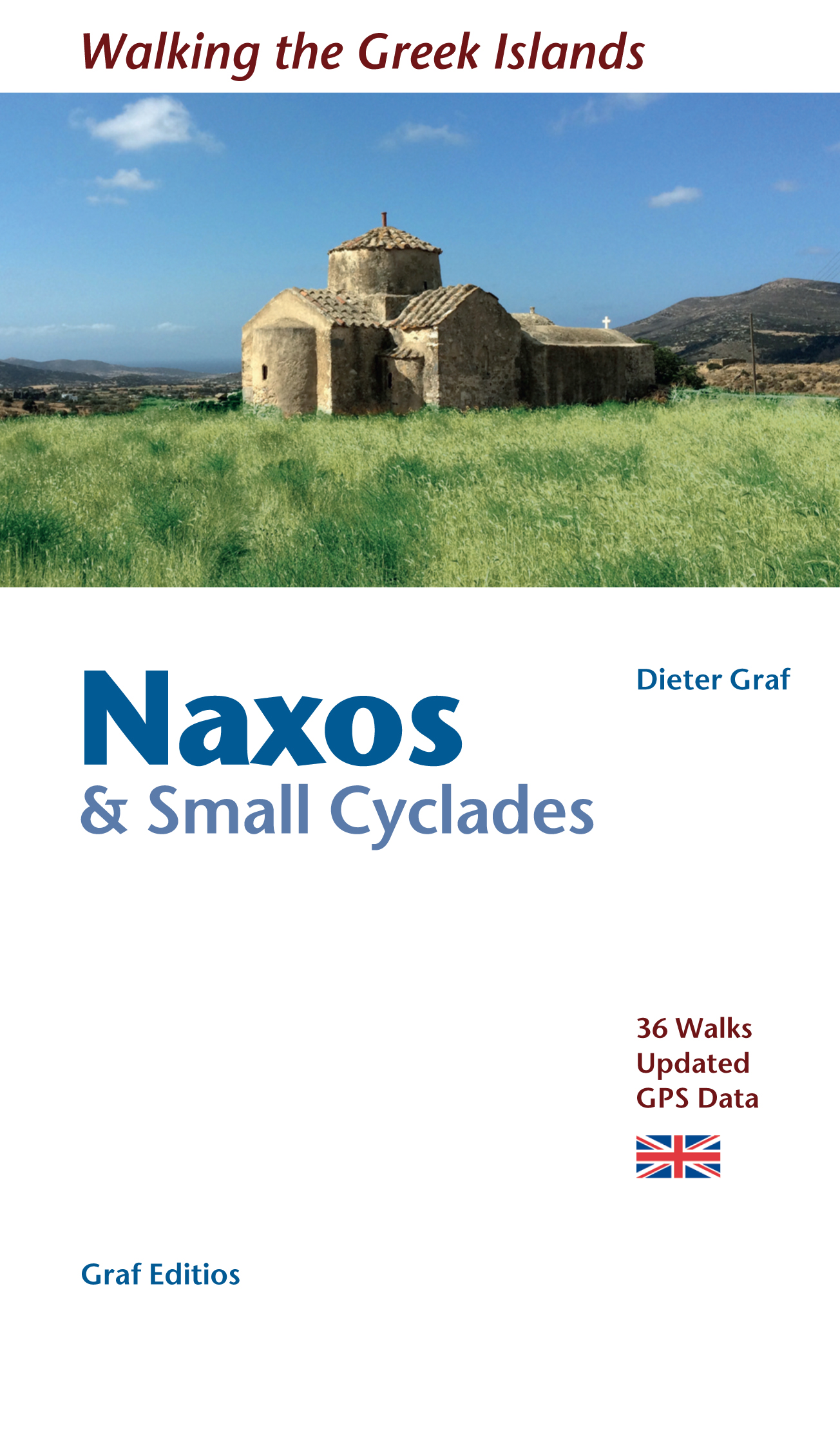
This book describes the loveliest old walking trails. With detailed maps, GPS data and route photos of outstanding points for better orientation. And lots of interesting facts worth knowing about the Islands of Dionysos.


Already when you sail into the harbour, you can sense the island's tremendous cultural diversity. On the left, you peer up at the enormous portal of a classical temple; on the right, you glide past a small Byzantine chapel and, towering above the huddled Cycladic city, a Venetian kástro from the Middle Ages. The city, dating back 5000 years, is one of the oldest inhabited places in the world.


When you penetrate further in to the island, you are surprised by the diversity of the fertile landscapes. An enormous rugged mountain massif – consisting of granite, gneiss and marble with three peaks rising to an altitude of almost 1000 metres – forms the background for the green heart of the island, the Tragéa plains, covered with olive groves and ancient oaks. Stretching further westwards is extensive farming land, until it meets a never-ending landscape of dunes along the seaside. Connoisseurs of small bathing bays can find wonderful spots along the rocky east coast.


However, it is not just nature which surprises with its enormous abundance. People have also left outstanding buildings during their long habitation of the island. Except in the lively Mediterranean harbour city, they tended – for reasons of security – to live in compact mountain villages which allow us, even today, to trace the tracks of old Greece. In addition to the white-washed cube houses, there are also a great number of castle-like residences from the Venetian nobility of the Middle Ages as well as fortress-like Orthodox and even Catholic monasteries. Art-lovers find not only the remains of classical temple complexes, but also monumental statues worked on by artists and left behind in ancient quarries. The Byzantine chapels from a later period house Early Medieval frescoes. Many finds from the numerous excavations on Náxos can be admired in the local museums.


For many visitors Náxos is the most beautiful island of the Cyclades, not least because it has been spared mass tourism. The pleasantly relaxed hospitality extended here will remain in the memory for a long while. Even the gods of the Greek Pantheon felt extremely comfortable here.

€ 29.99
Reisgids National Geographic Zuid-Afrika | Kosmos Uitgevers

National Geographic Reisgids Zuid-Afrika is een exclusieve gids met sublieme fotografie die u meeneemt naar de bekende en minder bekende bezienswaardigheden. De experts van National Geographic nemen een kijkje achter de schermen en dringen door tot de kern van de cultuur, de geschiedenis en het volk van het land. Bezoek met deze National Geographic Reisgids Zuid-Afrika de Kalahariwoestijn, de Diamantkust, het Namaqualand en de Malotibergen. Geniet van een braai op het strand, raadpleeg een Songoma of maak een kooiduik met haaien. Of ervaar de Freedom-wandeling, Durbans Golden Mile en een wandeling door de wijnvelden van de West-kaap. De uitgebreide kennismaking met Zuid-Afrika, het overzicht met belevenissen die je niet mag missen, de insider tips, de excursies buiten de gebaande paden en de reiswijzer met hotels en restaurants en de handige kaarten maken de gids compleet. Speciaal aanbevolen voor natuur- en cultuurliefhebbers!

€ 12.95
Reisgids - Fotoboek Skye | David Charles

Prachtig fotoboek met voldoende informatie om Skye goed te leren kennen.

The essential guide for the discerning tourist and island devotee, Skye describes everything the visitor needs to know about the islands' heritage, landscape, climate, flora and fauna. Contains fascinating information about all the key places of interest, from areas of outstanding beauty such as heather covered hills, to the ancient capital steeped in history. Illustrated with over 100 superb colour photographs showing every aspect of the island and its people.

€ 23.50
Reisverhaal Australië | Dolf de Vries

In Australië neemt schrijver en acteur (Soldaat van Oranje, Zwartboek) Dolf de Vries u mee naar de bruisende metropolen Sydney en Melbourne; naar de stille dorpjes en de uitgestrekte verlaten vlaktes; naar de groene regenwouden op Tasmanië en de droge rode aarde in de outback; en naar de koloniale huizen in Canberra en de holen in Burra. Hij beschrijft zijn reis door dit veelzijdige land in zijn eigen, persoonlijke stijl met vooral oog voor de mensen maar ook voor de geschiedenis en cultuur. Dit boek is een feest voor wie dit land wil bezoeken, wie er al eens is geweest en wie gewoon thuis iets te weten wil komen over Australië.

€ 7.95
Historische Kaart Groningen uit 1887 | GRAS

In het laatste kwart van de 19de eeuw werd de stad Groningen eindelijk verlost van haar vestingwallen. Eindelijk, want lange tijd moest de vesting onaangeroerd blijven. Groningen was immers een vestingstad en had een belangrijke rol in de landsverdediging. Dat kwam de veiligheid misschien ten goede, voor de ontwikkeling van de stad was het ongunstig. Buiten de vesting mocht niet gebouwd worden, en binnen de vesting nam het aantal inwoners toe. Dat zorgde niet bepaald voor een prettige, schone woonomgeving.

De Kaart van Casparie en Scholtens en Zoon uit 1887 is een van de eerste stadsplattegronden die de stad toont zonder haar vesting... al is de structuur van die vesting nog goed zichtbaar. De plattegrond toont een stad in ontwikkeling: rond het oude centrum, op de plek van de voormalige vestingwallen, ontwaren we verschillende bouwterreinen. Ook is de eerste nieuwe villabouw langs de singels en het Zuiderpark zichtbaar. Het Noorderplantsoen is al geheel ingetekend, al was de aanleg in werkelijkheid nog in volle gang. Ook laat de kaart zien hoe de stad inmiddels opgenomen is in het landelijke treinnetwerk. Er lopen spoorlijnen naar Leeuwarden en Zwolle.

€ 12.95
Wegenkaart - landkaart 583 Northeastern USA, Eastern Canada | Michelin

Wegenkaart van het noordoostelijke gedeelte van de USA (Kansas City - Fargo - Boston - Washington DC) en zuidoost Canada (Québec - Montréal - Ottawa - Winnipeg - Regina). Zie uitsnede op de voorkant van de kaart.

Primary & secondary road networks are clearly marked out with indications of the number of lanes, intermediate distances and various possible road obstacles or things you should know including steep hills, height limits, toll barriers, prohibited roads and roads subject to restrictions.


The map also includes small insets with street plans of the regions major towns, showing road names, one way streets and various places of interest (tourist sights, hospitals, parking, railway stations, etc.). Scenic routes on the map are marked out in green and an extensive index of place names is included.


The map also features:


Administrative boundaries

Railways, Airports and Ferry Services

Important sights such as castles, ruins, and churches

Driving Times and Distance Charts

Road Safety Information

A legend in multiple languages, including English


Canada, Côte Est américaine, Dakota, Est canadien, Midwest, New York (état), Nouveau-Brunswick, Nouvelle-Angleterre, Ontario, Québec


€ 18.50
Wandelgids 060 Pathfinder Guides Lake District | Ordnance Survey

Wandelgids van het Lake District, dit prachtige deel van Engeland. Deze gids bevat 28 dagwandelingen, variërend van korte tochten tot pittige dagtochten. De bijbehorende kaarten zijn uitstekend: men heeft de topografische kaarten van Ordnance Survey gebruikt waarop de route is ingetekend. Daarnaast praktische informatie over de wandeling en wat beschrijvingen van het gebied.

Are you planning a visit to the Lake District? Do you enjoy a walk in the country or a leisurely afternoon stroll? Britain's best loved walking guides brings you a brand new Pathfinder Guide to More Lake District Walks containing 28 fabulous walks exploring the wide range of landscapes offered by the UK's most popular walking region.

Offering something for walkers of all abilities, Pathfinder Guide to Lake District Walks contains:
* 28 easy to follow walks ranging in length from 2-15 miles - all clearly graded
* Large-scale Ordnance Survey route maps for each walk
* GPS waypoints for easy navigation
* Colour photography taken from points along each walk
* Facts about sights and points of interest visible along each route

Pathfinder Guides are Britain's best loved walking guides. Made with durable covers, they are the perfect companion for countryside walks throughout Britain. Each title features circular walks with easy-to-follow route descriptions, tried and tested by seasoned walkers and accompanied by beautiful photography and clear, large-scale Ordnance Survey mapping.

Praise for Pathfinder Guide to Lake District Walks: 'Taking you to all the popular bits plus to the less visited corners. It's clear, concise, sourced from OS mapping, and is also GPS waypointed for those who like their handy little gizmos alongside map and compass.' --Cumbria Magazine

Abonneer op