€ 22.99
Reisverhaal De grote spoorwegcarrousel | Paul Theroux


Paul Theroux reist vier maanden per trein door Azië. Hij doorkruist onder meer Turkije, Iran, Afghanistan, Pakistan, India, Sri Lanka, Thailand, Birma, Maleisië, Zuid-Vietnam en de Sovjet-Unie en neemt de ultrasnelle Japanse treinen, de Oriënt-Express en de Transsiberië-Express.

In zijn aanstekelijke stijl en met een scherp oog voor detail beschrijft Theroux de plaatsen en de mensen die hij onderweg tegenkomt - en daarbij spaart hij ook zichzelf niet. De grote spoorwegcarrousel verscheen voor het eerst in 1975 en is een moderne klassieker onder de reisboeken.

€ 13.50
Wandelgids - Pelgrimsroute Mosel - Camino | Conrad Stein Verlag

Prima wandelgidsje van deze route, kaartmateriaal beperkt aanwezig. Wel voldoende praktische informatie

Route langs de Moezel, van Koblenz naar Trier (160km)

Über rund 160 km (einschließlich Besichtigungen 180 km) verläuft der Mosel-Camino von Koblenz-Stolzenfels durch den geschichtsträchtigen Koblenzer Stadtwald (Merkurtempel), vorbei an Hünengräbern wie dem Bruder-Tönnes-Hügel,dann abwechselnd mal rechts, mal links an der lieblichen Mosel entlang bis zur ältesten Stadt Deutschlands, Trier, wo sich das einzige Apostelgrab (Matthias) nördlich der Alpen befindet. 


Dieser herrliche Jakobsweg führt an imposanten Burgen wie Thurant, Eltzund Marienburg, dem Schloss Stolzenfels, dem Bleidenberg, sehenswerten Orten wie Beilstein (Schwarze Madonna), Trarbach (Ruine Grevenburg) und Kues (Nikolaus von Kues) und den Klöstern Maria Engelport und Klausen vorbei. Immer wieder faszinieren einzigartige Panoramablicke ins Moseltal, in dem insbesondere der bekannte Rieslingwein angebaut wird. Die lebensfrohen und hilfsbereiten Bewohner der Region führen gerne mal ein Gespräch mit einem Pilger. Der nützliche Reisebegleiter beschreibt den präzisen Wegverlauf und die auf dem Camino befindlichen Sehenswürdigkeiten.Das handliche kleine Format ist ideal für unterwegs.


291, Alken, Bernkastel-Kues, Camino, Enkirch, Jakobspilger, Jakobsweg, Karl-Heinz Jung, Koblenz, Mosel, Mosel-Camino, Pilger, Pilgern, Pilgern in Deutschland, Schweich, Traben-Trarbach, Treis-Karden, Trier, Zell

€ 9.95
Wegenkaart - landkaart 117 Côte Normande | Michelin

Speciale toeristische kaart, gemaakt voor een goed bezocht gebied en uitvergroot. Daardoor zeer prettig leesbaar met een hoog nivo wat we van Michelin al veel langer gewend zijn. Alle wegen staan er op, met verschillende kleuren voor de aparte soorten wegen. Verder veel aandacht met symbolen voor de bezienswaardigheden in de regio, de bekende groene stroken naast de mooie wegen en ingetekende doorgaande wandelroutes als grande randonnees.

Caen, Dieppe, Rouen, St-Lô

€ 11.95
Wegenkaart - landkaart 722 Frankrijk recto-verso 2024 | Michelin

Zoals je van Michelin mag verwachten is deze kaart zeer overzichtelijk en heeft een duidelijk helder kaartbeeld. De kaart geeft uitgebreide toeristische informatie weer. De perfecte overzichtskaart!

Frankrijk op twee kanten van de kaart, vandaar de naam recto-verso

De serie landkaarten van Michelin zijn over het algemeen de meest duidelijke en prettige kaarten voor de grote lijn. Met hoofdwegennet en voornaamste provinciale/regionale netwerk zijn ze minder geschikt voor de binnendoorwegen of het vinden van de kleinere plaatsen. Veel feitelijke informatie zoals duidelijke wegnummering, tussenafstanden, afslagen en indien van toepassing ook de scheepvaartverbindingen. Heldere cartografie en prettige rustieke kleurstelling. Voorzien van plaatsnamenregiser en afstandentabel.

Ajaccio, Bordeaux, Brest, Clermont-Ferrand, France, Le Havre, Lille, Lyon, Marseille, Nantes, Nice, Paris, Strasbourg, Toulouse

€ 24.95
Reisgids Handbook Central America | Footprint

Zo mogelijk nog completer dan de Lonely Planet: dezelfde doelgroep - rugzakker, zelfstandig reizenden -, dezelfde informatie als slaapgelegenheden, vervoer etc. Veel internetverwijzingen. Naast deze grote hoeveelheid praktische informatie ook veel achtergrondinfo over cultuur, land en bevolking.

The Central America isthmus is home to exuberant swathes of rainforest and a tapestry of cultures. Footprint's 21th edition Central America Handbook will guide you from jungle-shrouded Mayan ruins, through ethereal cloud forests, to pristine, sun-soaked islands.


Great coverage of the activities and sights in Southern Mexico, Guatemala, Belize, Honduras, El Salvador, Nicaragua, Costa Rica and Panama

Loaded with information and suggestions on how to get off the beaten track, from bohemian towns to stunning volcanoes

Includes comprehensive information on everything from transport & practicalities to history, culture & landscape

Plus all the usual accommodation, eating and drinking listings for every budget

Full-colour planning section to inspire you and help you find the best experiences

Personal recommendations from the author on everything from festivals and national parks, to kayaking and caving

€ 20.95
Reisgids Baja | Moon Travel Guides

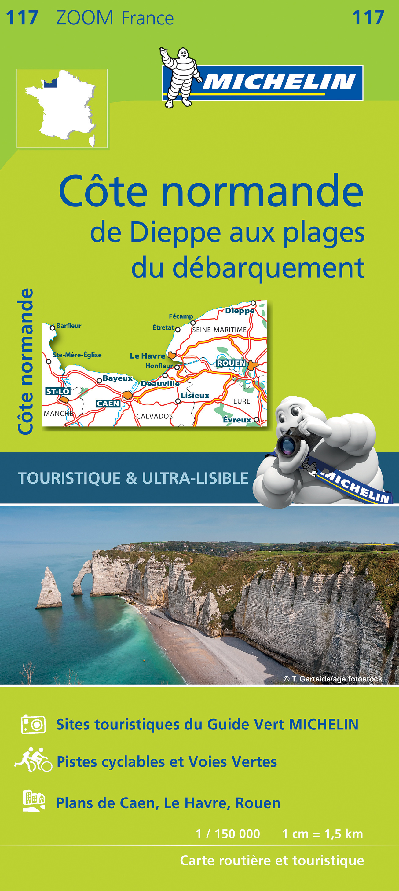
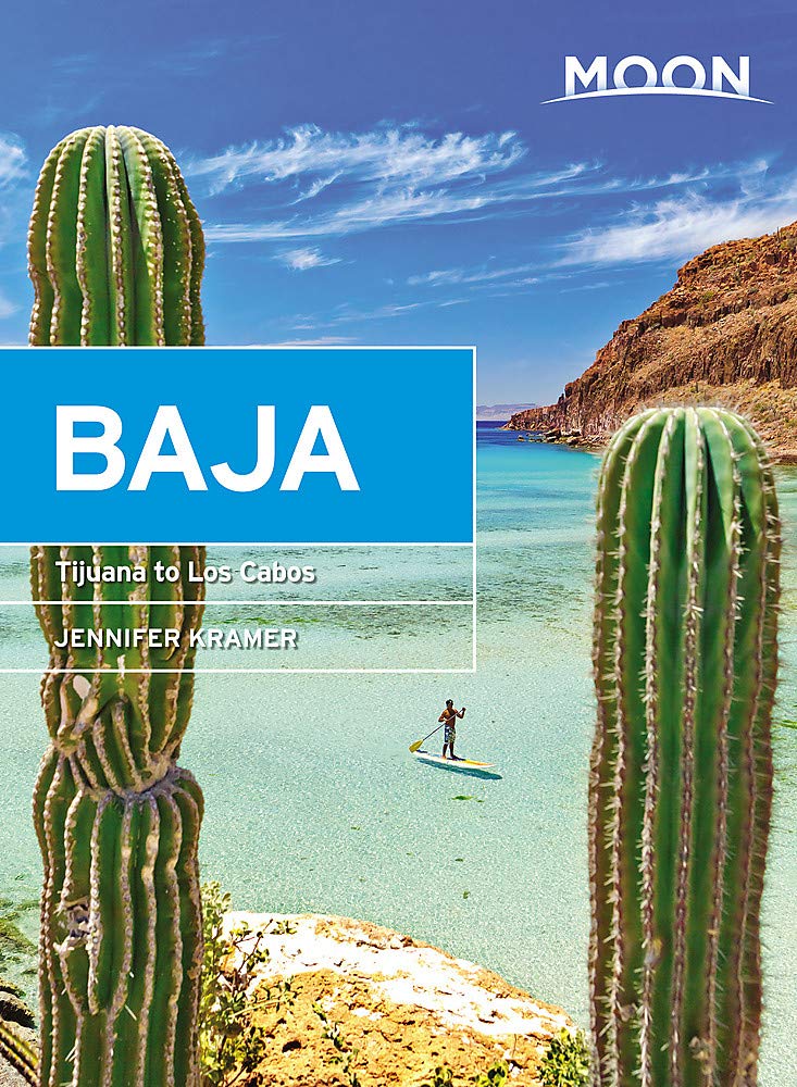
Uitstekende Amerikaanse reisgids van uitgever Moon. De gids is vergelijkbaar met Lonely Planet en Rough guide en is voor de backpacker - zelfstandige reiziger geschreven; toch is deze door de grote mate van details en achtergronden geschikt voor alle reizigers! De gids onderscheidt zich door gedegen en uitgebreide achtergrondinformatie over bijvoorbeeld natuur en cultuur.

Baja California has a little bit of everything: warm, turquoise ocean and white-sand beaches, rugged desert mountain ranges, and cities bursting with art, culture, and delicious cuisine. Immerse yourself in the unique culture of this welcoming and colorful peninsula with Moon Baja.


What You’ll Find in the Moon Baja travel guidebook:

Curated advice from local writer and tour guide Jennifer Kramer, who has spent nearly 30 years sharing all that Baja has to offer

Full-color with vibrant, helpful photos

Detailed directions and maps for exploring on your own

In-depth coverage of Tijuana, Ensenada, and Valle de Guadalupe, Mexicali, San Felipe, and Sierra de Juárez, San Quintín and Bahía de los Ángeles, Guerrero Negro and El Vizcaíno, Loreto and Bahía Magdalena, La Paz, The East Cape and the Sierra de la Laguna, Los Cabos, and Todo Santos and the West Cape

Activities and ideas for every traveler: Cruise down Mexico’s Highway 1 with endless desert as a backdrop and the warm Baja breeze in your face. Sip a cerveza from your hammock, or take a panga ride out to see dolphins, whales, and sharks in the Sea of Cortéz. Go wine or beer tasting in Ensenada, sample the freshest fish tacos on the beaches of Los Cabos, or shop for beautiful artisan goods in Loreto. Watch the sun set over the ocean, followed by bonfires on the beach with a blanket of stars overhead

Strategic itineraries in an easy-to-navigate format, such as Classic Baja Road Trip, Marine Adventures, Exploring the Sierra, and The Foodie Scene

Helpful background information on the landscape, culture, history, and environment

Essential insight for travelers on health and safety, recreation, transportation, and accommodations, as well as a handy Spanish phrasebook, packaged in a book light enough to fit in your beach bag

With Moon Baja’s practical tips, myriad activities, and an insiders view on the best things to do and see, you can plan your trip your way.

€ 74.95
Wereldkaart 22008 Politiek, 176 x 122 cm | National Geographic

Politieke wereldkaart van National Geographic. De klassieke blauwe vorm, met helder kaartbeeld. De landen hebben met kleuren duidelijke grenzen en er staan opvallend veel topografische details op. Ondanks de schaal een behoorlijk aantal plaatsnamen. Mooi vormgegeven met een klassieke rand er om heen.


Groot formaat 176 x 122 cm / geplastificeerde versie.


This world map features the Winkel Tripel projection to reduce distortion of land masses as they near the poles. Features include subtle border coloring on land, and prevailing winds and ocean currents at sea. Separate insets show the North and South Polar Regions, world vegetation and land use, and world population density.

€ 66.95
Wereldkaart 68P-zvl Political, 196 x 120 cm | Maps International

Prachtige wereldkaart . Door het heldere en vrij felle kleurgebruik is deze kaart uitermate geschikt voor scholen, kantoren of gewoon als politieke wereldkaart thuis. De kleurstellig is zodanig dat elk land zich zeer goed onderscheidt van haar buren. De natuurkundige aspecten zijn minder goed te zien, al worden de gebergten door schaduwwerking goed uitgelicht. De nadruk ligt echter duidelijk op een ‘gewone’ wereldkaart. De belettering is uitstekend leesbaar door vetgedrukte naamgeving.

Engelstalig, maat 196 x 120 cm. (deze maat is alleen in het Engels leverbaar, de maten 68x45 en 136x86 zijn wel in het Nederlands). Geplastificeerde versie.

€ 24.95
Wandelgids Walking on Tenerife | Cicerone


From easy strolls to hands-on scrambling and from simple day walks to long-distance routes along the GR131, Tenerife offers a variety of year round walking routes, all set in stunning natural scenery. Paddy Dillon's latest book in his Canary Islands series features 45 of the best - suitable for a wide range of abilities and easily combined to form longer expeditions.


The largest of the Canary Islands, Tenerife is dominated by the highest mountain on Spanish territory, El Teide, which rises up dramatically right in the centre of the island. The whole central area surrounding it is protected as a national park and packed with diverse and interesting trails. The altitude on these routes is generally above 2000m and the island's central high-altitude region is often blessed with blue skies and sunny conditions, even when other areas are covered in cloud or experiencing rain.


Terrain includes volcanic cones, lava flows and ash slopes, while the landscape ranges from semi-desert to lush laurisilva and pine forests, all in one of the world's most popular tourist destinations. It takes time to explore Tenerife on foot, and many people return here year after year to discover more and more for themselves. Some routes link with traditional mountain villages, and all span a wide range of habitat and climatic types.


45 routes described with clear contour mapping

includes a ‘Three Peaks of Tenerife’ challenge for the tough and determined

the third in a five-book series of guides to the Canaries, which include Walking on La Palma and Walking on La Gomera and El Hierro

€ 16.95
Reisgids Ben le Vay's Eccentric Oxford | Bradt Travel Guides

Aan de hand van allerlei zinnige en onzinnige feitjes over het heen en verleden van Oxford krijg je een origineel beeld van de stad voorgeschoteld.

Dreaming spires, honeyed stone, cycling dons ... forget all that tourist twaddle, says Benedict le Vay. Find out the secrets the colleges don't want you to know, the inside track on the best pubs and eating places, the scandal and gossip about nutty professors and disgraceful students past and present, the brilliant stories about the great, the good and the bad. 

William Morris called Oxford 'a perfect jewel' of a city; Benedict le Vay goes in search of the quirkier gems among its medieval back alleys. Here roam batty dons, daft students, barmy aristocrats and political firebrands. Who does that gargoyle remind you of? Why is a shark plunging into that man's house? When do students jump naked into the River Cherwell as Latin hymns are sung? What powers the 'Cosmic Triangle' of vibrant East Oxford? How do you control a punt without looking like a plonker?

• The pubs where Inspector Morse and Bill Clinton enjoyed a pint
• Where to eat a great fry-up in a unique setting
• Where to find a weird museum
• Calendar of annual eccentric events

Abonneer op