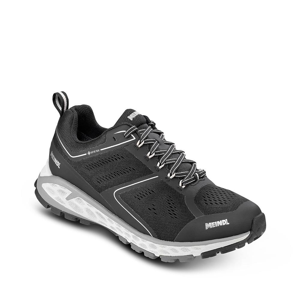
€ 12.00
Wandelkaart Massiccio del Grappa | Club Alpino Italiano

Topografische kaart van het massief rond Monte Grappa in de Dolomieten. Zeer gedetailleerd met alle topografische details, daarnaast zijn op deze kaart de wandelroutes ingetekend. Ook vind je campings, berghutten en bivak's terug op de kaart. 

€ 45.00
Wandelgids - Reisinspiratieboek Wanderlust | Kosmos Uitgevers

Sla Wanderlust open voor de mooiste en meest legendarische wandelroutes ter wereld. Van hikes door de spannende Canyon Trail in het Zion National Park, de avontuurlijke Caminito del Rey in Spanje of het pelgrimspad op de heilige Kumano Kodo in Japan. Over dun ijs en woestijnzand, langs de kust of over bospaden. Spectaculaire fotografie illustreert fenomenale vergezichten en locaties. Met kaarten, achtergrondinformatie en praktische tips kan iedereen de wereld verkennen, of je nu een beginner of een ervaren hiker bent.

Het boek bevat hikeroutes in Europa, Azië, Afrika, Australië en Noord- en Zuid-Amerika. Zo komt het Koningspad (El Caminito del Rey) in Malaga voorbij. Deze hikeroute is in het jaar 2000 gesloten, maar is na renovatie in 2015 weer officieel geopend. Toch hebben vele waaghalzen in deze 15 tussenliggende jaren de wandelroute gelopen. Ook staat er een route in over vulkanisch grondgebied in Nieuw-Zeeland. Deze route is uitgeroepen tot de beste 1-dagshike van Nieuw-Zeeland en telt 19,4 kilometer.


€ 29.95
Wandelkaart 3023 Topo 3000 Indre Etnefjell | Nordeca

Een nieuwe serie van Nordeca. Een grote kaart op scheurvast papier. Het heldere kaartbeeld wat we van de andere series ook kennen is hier gebruikt wat de kaart goed leesbaar maakt. 


Topo 3000 is a detailed map covering an area of 64 x 47 km (over 3000 km2) Here you will find the hiking routes easily, over the mountains, through the forest and along the roads. Lodgings are emphasised to facilitate your planning.


Kartet dekker: Langfoss - Etne - Sauda - Husnes - Åkrafjorden - Halsnøy - Uskedalen - Ølen

- Detaljert og lettlest

- Dekker over 3000km2

- Målestokk: 1:50 000

- Tåler vann og hard bruk

- Tydelige avmerkede turstier

- Hytter og overnatting

€ 15.95
Wandelkaart Tour & Trail Zakynthos | Discovery Walking Guides

Goede scheur- en watervaste wandelkaart van Zakynthos.

For the best adventures, use the best map. Water-proof, split-proof, tear-proof, adventure-proof. Zakynthos (Zante) Tour & Trail Super-Durable Map is simply the toughest, most accurate, easy to read, easy to use map of the island you can buy at any price.


Super-Durable Maps come with a 2 year adventurous use `Wear and Tear' guarantee. A large 840mm by 694mm double sided map sheet has Zakynthos (Zante) at 1:35,000 scale with the North-West of the island on the cover side and the South-East on the reverse. There is a very generous overlap between the two sides so the only time you need to turn the map over is if you are driving from Cape Skinari (NW) to Cape Gerakas (SE) at the opposite end of the island.


Our special concertina map fold makes our map easy to use and easy to refold to its 235mm by 120mm pocket size. You can also download the digital Custom Map edition of our Zakynthos Tour & Trail Map for use with Garmin gps units and software; simply follow the instructions on the map sheet. Our legendary 'Tour & Trail' level of detail ranges from major roads to secondary roads to minor roads to streets and narrow country roads, plus dirt roads and walking trails.


Place names are in English and Greek to aid your navigation. Altitude shading is designed to clearly show the altitude range when travelling across the island by car or on foot. 100 metre and 20 metre contours are clearly shown on the map along with individual height points and all of the official 'Trig' points.


Tour & Trail attention to detail includes our useful symbol range including viewpoints, picnic areas, petrol stations, bar/restaurants and parking areas where you can pull off the road safely. You will easily identify springs, caves, sports grounds, cemeteries, churches, chapels, lighthouses, towers and forts, camping areas, wind turbines, hotels etc. We have ensured that all the walking routes from the Sunflower walking guide book are highlighted (red) on the maps.

€ 14.95
Reisgids Marco Polo NL Sardinië | 62Damrak

Marco Polo reisgids voor Sardinië. Handig pocketformaat, boordevol informatie, met uitneembare kaart achter in het boek en atlas-pagina’s. Met Insider Tips om de échte stad/streek te ontdekken en de TOP 15 van bezienswaardigheden in één oogopslag. Veel up-to-date informatie in overzichtelijke hoofdstukken: sightseeing, eten & drinken, winkelen, uitgaan, verblijf, routes & tochten, voor kinderen, feesten, festivals & evenementen, internet tips, praktische info van a tot z, een taalgidsje, plattegronden en straatnamenregister.

€ 10.95
Spel Stadskwartet Groningen | Scala Leuker Leren

Verken Groningen spelenderwijs met dit kleurrijke kwartetspel!


Er gaat niets boven Groningen! Ga mee naar de Martinitoren, het Academiegebouw, de Apenrots, de watertoren en het Pannekoekenschip. Bezoek Bommen Berend, het Groninger Museum en Grafisch Museum Grid of slenter door de gezellige winkelstraten en pik een terrasje. Proef mollebonen en eierballen en ontdek hoe leuk Groningen is.


Speel dit leuke fotokwartet en toer langs de belangrijkste bezienswaardigheden. Het spel bevat 20 kwartetten over diverse bekende en verborgen pareltjes van Stad. Met Engelse vertaling.


2 – 4 spelers / players or teams

leeftijd/age 10+

€ 19.95
Wandelkaart 25 Valls d'Àneu | Editorial Alpina

Zeer gedetailleerde wandelkaart van een klein gebied. Met ingetekende wandelroutes en andere informatie. Spaanstalig, maar uitstekende kaart. Coordinaten zijn weergegeven, dus GPS compatible met UTM grid. 


Op de topografische wandelkaart worden o.a. berghutten, campings aangeduid en hoogtelijnen, ingetekende wandelroutes en de GR paden (doorgaande langeafstandswandelpaden). De kaart is inclusief een Spaanstalig boekje met extra informatie over aanwezige voorzieningen en enkele routes.


Dorpen en Bergen: Port d'Orla, Estanh Long, Montgarri, Tuc de Bacivèr, Estany d'Airoto, Cap del Port, Borèn, Estany Gerber, Sant Salvador, Estany de Sant Maurici, Espot, la Guingueta d'Aneu, Estaon, Esterri d'Aneu, Cerbi, Gavas, Estany Major, Alós d'Isil, Mont-roig, Pic de Colada, Mont Valier, Couflens, 


€ 12.95
Wandelkaart The Dales Way | Footprint maps

Handzame wandelkaart voor de Dales Way in Noord Engeland. 

The Dales Way is a 79 mile (127km) long distance trail in the north of England, running between Ilkley, in North Yorkshire and Bowness-on-Windermere, in Cumbria. Much of the route passes through the Yorkshire Dales and Lake District National Parks. Starting out in Ilkley, the route runs along Wharfedale, passing the impressive ruins of Bolton Priory and the attractive market town of Grassington. It continues along the River Wharfe through dramatic limestone scenery before it crosses The Pennines to reach Dentdale and Sedbergh. It then skirts the Howgill Fells and crosses the M6 motorway to finish overlooking Lake Windermere.


This map-guide is laid out for walkers travelling from Ilkley to Bowness, although walkers travelling in the opposite direction should find it equally useful. Each panel includes a detailed route map, route profile and helpful notes on navigation.


There are link routes from Bradford, Leeds and Harrogate to the start of the route at Ilkley.

€ 14.95
Wandelkaart Fort William | Footprint maps

Gedetailleerde wandelkaart van dit gedeelte van Schotland. Ook zeer geschikt voor de mountainbike. Op de achterzijde detailkaartjes met wandel- en mountainbikeroutes. Inclusief veel praktische informatie.

This specially produced map & guide shows all the paths, tracks and trails in this popular part of Western Scotland, rightly called The Outdoor Capital of the UK. The map also includes lots of other useful information for when you're out and about; from where to get a bite to eat to hiring or fixing your bike.


Use the main map to plan your own route or use the individual maps overleaf to follow one of the suggested routes which have been carefully selected to take in some the best trails and views in the area.


Side 1: an overview map of Glen Nevis, Caledonian Canal, Spean Bridge & Nevis range


Side 2: nine specially surveyed routes for walkers, mountain bikers and trail runners. Each route is shown on its own map and is accompanied by detailed navigation notes.

€ 17.50
Wandelgids Bourgogne (Franstalig) | Rother Bergverlag

Uitstekende wandelgids met een groot aantal dagtochten in dal en hooggebergte. Met praktische informatie en beperkt kaartmateriaal! Wandelingen in verschillende zwaarte weergegeven in rood/blauw/zwart.

cartes de randonnée détaillées

profils d’altitude informatifs

traces GPS à télécharger

La Bourgogne est célèbre pour l'excellence de ses vins, sa gastronomie et ses nombreux monuments historiques et religieux. Mais aller y faire de la randonnée ? Peu nombreux sont ceux qui y pensent, - bien à tort. Le paysage y est très varié, et on est souvent seul sur les chemins.

Le guide de randonnée Rother « Bourgogne » se concentre sur le parc naturel du Morvan. Une jolie région aux collines couvertes de forêts, avec une flore et une faune riches et de nombreux lacs enchanteurs. Le sommet le plus haut ne s’élève qu’à 901 mètres, mais il ne faut pas sous-estimer les dénivelés. Les formations rocheuses du Saussois et de Bouilland peuvent même procurer des sensations « alpines ». Dans le Nord, on trouve également un paysage de collines avec des prés, des pâturages et des forêts. À l'Ouest, les randonnées traversent les vallées de deux fleuves encore sauplateau de Saône et dans les paysages marécageux de la Bresse avec ses nombreux étangs. Enfin, au sud, les chemins passent par des collines douces et des pâturages luxuriants où paissent les célèbres bœufs charolais. De nombreux canaux sillonnent la région et invitent à flâner tranquillement sur leurs rives.

La Bourgogne est une région idéale pour tous ceux qui aiment associer randonnée et culture aux plaisirs de la table, et le guide de randonnée Rother vous sera un compagnon fiable. Les descriptions détaillées des itinéraires sont complétées par de nombreuses indications sur l'histoire et des informations sur les plus belles excursions. Les itinéraires sont faciles à suivre en toute sécurité grâce à des extraits de carte détaillés avec indication de l'itinéraire ainsi que des profils altimétriques appropriés. Le niveau de difficulté représenté par des couleurs facilite le choix des itinéraires.

Abonneer op