€ 13.95
Stadsplattegrond Innsbruck | Freytag & Berndt

Stadsplattegrond met register. Helder kaartbeeld waarbij de naamgeving goed leesbaar is weergegeven. Met de toeristische bezienswaardigheden in symbolen weergeven: monumenten, musea, stadions e.a. Daarnaast handige zaken als postkantoren, parkeergarages en stations. Veelal ook met een openbaar vervoer of metro kaart als inzet

€ 13.95
Stadsplattegrond Barcelona | Freytag & Berndt

Stadsplattegrond met register. Helder kaartbeeld waarbij de naamgeving goed leesbaar is weergegeven. Met de toeristische bezienswaardigheden in symbolen weergeven: monumenten, musea, stadions e.a. Daarnaast handige zaken als postkantoren, parkeergarages en stations. Veelal ook met een openbaar vervoer of metro kaart als inzet.

Explore Barcelona with this Freytag & Berndt map. The best way to plan your trip, prepare your itinerary, and to travel independently in this country. As with all Freytag & Berndt maps the cartography is clear and detailed with the topography shown by relief shading with plenty of spot heights.


One side features a detailed map of the city of Barcelona, as well as an inset of the greater area around the city in Spain. The flipside features the index for the map. 


Freytag & Berndt maps make good use of an icon system. Icons show tourist information such as:


Places of interest

Churches, museums and theatres

Parks and gardens


Distances between points are shown as well as indications of steep gradients, all distances are in kilometres. The legend is in several languages including English.

€ 475.00
Magneetbord 28M Wereldkaart, politiek & antiek, 185 x 122 xm | National Geographic

Een prachtige, stijlvol gekleurde kaart - bruin, antieke uitstraling - met een modern kaartbeeld. Alle landen staan er met grenzen en belangrijke steden keurig op, maar de nadruk ligt op de kleurstelling: deze is ‘ouderwets‘ en past goed in een klassiek interieur. Door het kleurgebruik is het reliëf van de bodem van oceanen goed te zien.


Het is de meest verkochte wereldkaart uit ons assortiment!


De kaart wordt in deze versie gelijmd op een plaat, voorzien van een mooie aluminium lijst en een ophangsysteem wordt meegeleverd. Daarnaast krijgt u een bakje bijgeleverd dat u er aan kunt bevestigen voor pennen, stiften of magneetjes.


Bij dit magneetbord wordt een set magneetjes (10 stuks) gratis meegeleverd


National Geographic is a renowned authority in cartography. For 120 years the Society's maps have helped spread geographic knowledge around the globe. A vast database allows National Geographic to combine the latest data gained by space-age technology with innovative digital mapping techniques to create state-of-the-art political, physical, and thematic maps. The Society's meticulous research and attention to detail have established a standard of achievement that is unparalleled.


A current political map that features our world in rich, earth-toned colors. Astounding detail and boardroom quality make this map excellent for reference in your home or office. Features the Winkel Tripel projection to reduce distortion of land masses as they near the poles

€ 11.50
Wegenkaart - landkaart Nieuw - Zeeland | Borch

Mooie geplasticieerde kaart van Nieuw - Zeeland. Deze kaart biedt een goed overzicht van het land met detailkaarten.


Our soft-laminated map of New Zealand includes: North Island 1:1 300 000,

South Island 1:1 300 000, Auckland 1:20 000, Christchurch 1:20 000, Dunedin 1:15 000, 

Nelson 1:15 000, Rotorua 1:15 000, Queenstown 1:15 000, Wellington 1:20 000, New Zealand administrative & time zones, interesting statistics, conversion chart for temperatures, weights and measures, climate chart with temperatures, sunshine hours, precipitation and humidity and much more.


"4 million inhabitants and 60 million sheep" does not do justice to the charm and natural diversity of this beautiful country. Lush meadows and fertile soils are only some of the natural resources with which New Zealand is endowed, the real natural wealth of this island state in the middle of the South Pacific lies in its incredibly diverse landscape: snow-covered mountains, dense forests, lush green lowlands, crystal-clear rivers and lakes, endless beaches and majestic fjords, even rainforests and volcanoes. New Zealanders know what their homeland has to offer: the skiing season lasts all year in the magnificent alps of South Island; climbers and hikers come here to test their strength against nature; anglers hunt for swordfish in the coastal waters or fish for trout in Lake Taupo; there are beautiful camp sites to be found everywhere. New Zealand is paradise for nature and sport lovers, and you can always be sure of a warm welcome from the friendly locals.


€ 11.50
Wegenkaart - landkaart Groot - Brittannië | Borch

Mooie geplasticieerde kaart van Groot - Brittanië. Deze kaart biedt een goed overzicht van het land met detailkaarten.


Our soft-laminated folded map of Great Britain shows: Scotland and Northern Ireland 1:800 000, England and Wales 1:800 000, Channel Crossings 1:800 000, Great Britain and Ireland administrative, Europe time zones. Borch Maps are easy to fold, durable and water-repellent with a wipeable surface. Borch Maps show hotels, museums, monuments, markets, public transport, top sights and points of interest, useful statistics, conversion charts for temperatures, weights and measurements, climate charts showing temperatures, sunshine hours, precipitation and humidity, overview maps, time zones, and much more...


"Great Britain", the largest island in Europe, is not one individual country, but the combination of Wales, England and Scotland. It also includes smaller islands such as the Hebrides, the Isle of Wight, Anglesy, the Isles of Scilly as well as the Shetland and Orkney Islands (but not the Channel Islands, nor the Isle of Man, which are Crown Dependencies and not part of the U.K.). Together with Northern Ireland, Great Britain comprises the United Kingdom. While rugged hills and mountains are predominent in the north and west, quiet rolling meadows and countryside are to be found in the southern and eastern regions of the island. Lovely landscapes with beautiful coastlines, friendly and courteous people, world-famous cities bursting with historic landmarks and culture in every respect, are just a few of many reasons to visit this great island.


€ 11.50
Wegenkaart - landkaart Duitsland | Borch

Mooie geplasticieerde kaart van Duitsland. Deze kaart biedt een goed overzicht van het land met detailkaarten.


Our soft-laminated folded map of Germany shows: Germany North 1:800 000, Germany South 1:800 000, Germany administrative, Europe time zones. Borch Maps are easy to fold, durable and water-repellent with a wipeable surface. Borch Maps show hotels, museums, monuments, markets, public transport, top sights and points of interest, useful statistics, conversion charts for temperatures, weights and measurements, climate charts showing temperatures, sunshine hours, precipitation and humidity, overview maps, time zones, and much more...


The Federal Republic of Germany is situated in Central Europe and is a parliamentary federal republic of 16 states, among them the capital city Berlin counting as a city-state. Germany was a founding member of the European Union, is the largest country of the Union according to population, is counted as one of the modern world powers, is one of the world's leading exporters of goods, the third largest importer of goods, the world's fourth largest economy, with the ninth highest defense expenditure in the world / third highest in the EU. Besides being in the EU, Germany is a member state of the UN, NATO, the G8 and G20, among others. Germany, a country of beautiful landscapes varying from sandy coastal regions to rugged mountains, rolling meadows and great forested areas to meandering riverbeds bordered by vineyards, is also a land of cultural diversity boasting beer and wine festivals, museums of world esteem, romantic villages and towns and busy cities. Germans are conscientious and friendly and are known for their precision, punctuality, cleanliness and technical innovations. A modern beautiful country worth visiting.


€ 11.50
Wegenkaart - landkaart Frankrijk | Borch

Mooie geplasticieerde kaart van Frankrijk. Deze kaart biedt een goed overzicht van het land met detailkaarten.

Our soft-laminated folded map of France shows: France North 1:875 000, France South 1:875 000, Corsica 1: 875 000, France administrative, Europe time zones. Borch Maps are easy to fold, durable and water-repellent with a wipeable surface. Borch Maps show hotels, museums, monuments, markets, public transport, top sights and points of interest, useful statistics, conversion charts for temperatures, weights and measurements, climate charts showing temperatures, sunshine hours, precipitation and humidity, overview maps, time zones, and much more...


France, one of the largest countries in Western Europe, is bordered by the English Channel, the North Sea and the Benelux countries to the north. To the East the Rhine river creates a natural border, as do the mountains toward Switzerland and Italy down to the shores and picturesque fishing villages of the Mediterranean coast. The majestic Pyrenees mountains separate France from its southerly neighbour, Spain. Rugged, beautiful coastal regions border the Atlantic Ocean to the west. "La Republique Francaise" is France’s official name and the 65 million French are a democracy-loving people whose ideals are clearly articulated in the famous slogan of the French Revolution: "Liberty, Equality, Fraternity". Besides being a highly-developed country with the fifth-largest economy in the world, France is the world's most popular international tourist destination, boasting more than 80 million foreign visitors annually. Diverse landscapes and leisure, cultural highlights, exquisite fashions and perfumes and fine food and wines make France an unforgettable destination!

€ 14.75
Wandelkaart Kilimanjaro National Park Map | Harms IC Verlag

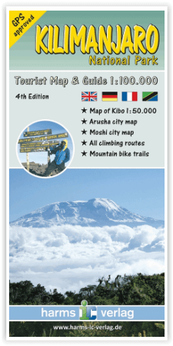
Detailed 1:100 000 topographic map of the extended National Park area contains controus, coloured elevation layers and vegetation zones. To improve its 3D impression of the relief, it includes a quality hillshading.

The map shows the official Kilimanjaro trekking routes, all GPS approved and captured by mountain guides, also various map symbols with tourist information - huts, viewpoints, points of interest and more.

Uselful additions are city maps of Arusha and Moshi, a detailed 1:50 000 of the Kibo area and a general map of northern Tanzania.

English, German, French and Kisuaheli

Comprehensive guide in englisha and german describing the tekking/climbing routes, the geology and botany of the area - also coloured photos.

Das gesamte Nationalparkgebiet wird im Maßstab 1:100.000 detailgetreu wiedergegeben. Die Geländeformen werden durch Höhenlinien, farbige Höhenschichten und eine Reliefschummerung ideal repräsentiert.

Die Karte enthält sämtliche aktuelle Trekkingrouten auf den Mount Kilimanjaro - alle GPS-geprüft.

Sinnvolle Ergänzungen zur Hauptkarte sind die Stadtpläne von Moshi und Arusha, ein Detailplan der Gipfelregion des Kibo im Maßstab 1:50.000 und eine Übersichtskarte des nördlichen Tansania.

Zweisprachige Texte (Deutsch und Englisch), illustriert mit Skizzen und vielen aussagekräftigen Farbfotos, geben Auskunft zu Geologie, Botanik, Klima- und Vegetationszonen und anderen Fakten. Alle Trekkingrouten sind ausführlich beschrieben.

Viersprachige Legende: Englisch, Deutsch, Französisch und Kisuaheli.

Die Karte ist beidseitig vierfarbig bedruckt im Format 87 x 60 cm, gefaltet auf 9,7 x 20 cm.

€ 10.99
Wegenkaart - landkaart 4 Normandië - Picardië - Parijs | ANWB Media

De ANWB heeft een grote serie wegenkaarten van de belangrijkste landen en streken. Het zijn echte overzichtskaarten van vaak een wat groter gebied. Deze keuze zorgt er voor dat de schaal vrij grof is en bepaalde details zijn weggelaten. De kleurstelling is een beetje flets waardoor je niet altijd even makkelijk onderscheid kan maken tussen verschillende landschappen of natuurlijke aspecten. 

Ook het register ontbreekt. Het grote voordeel is vaak dat het gebied op de kaart overeenkomt met de vraag van klanten. Voor het plannen van een vakantie een prima kaart!


Vergeleken met andere uitgevers van kaarten als Michelin, Freytag und Berndt of Reise KnowHow heeft de ANWB duidelijke keuzes gemaakt en gekozen voor een echte overzichtskaart. 


MET DE ANWB WEGENKAART, WEET JE WAAR JE STAAT! ANWB wegenkaarten zijn een begrip in het land. Dat laten de verkoopcijfers ook zien. Afgelopen decennia zijn meer dan 10 miljoen kaarten over de toonbank gegaan. De wegenkaarten zijn allemaal vernieuwd, met dikker karton voor de omslagen en papier dat minder makkelijk scheurt, zodat ze veelvuldig in- en uitgevouwen kunnen worden. Ze bieden een duidelijker overzicht van het wegennet en zijn nu nog compacter en handzamer. 

€ 18.95
Wandelgids 178 Niederlande - Nederland | Rother Bergverlag

Duitstalige wandelgids met zeer goed beschreven wandelingen in de genoemde gebieden. Redelijk kaartmateriaal, vooral de beschrijving van de route en de praktische info die er bij hoort is goed.

Die Niederlande - das sind Gegenden mit meist vollkommen waagerechtem Horizont, lediglich im äußersten Süden findet man eine Hügelkulisse. Trotzdem aber bietet das als Fahrradparadies bekannte Land Wanderern eine überraschende Vielzahl an abwechslungsreichen Tourenmöglichkeiten: Dünen, Deiche und Moränenlandschaften ermöglichen ebenso wie Aussichtstürme eine fantastische Sicht in den unendlich weiten Raum, die Wälder sind mal lieblich und von Sonnenlicht durchflutet, mal wild und urwaldartig, und auch die größte Heidelandschaft, die größte Binnendüne und die größte Sumpflandschaft Westeuropas finden sich hier. Nicht zu vergessen natürlich die zahlreichen Windmühlen, die idyllischen Dörfer und lieblichen Städtchen, die es zu entdecken lohnt.
Die Touren in diesem Rother Wanderführer reichen vom zweistündigen Spaziergang bis zur tagesfüllenden Unternehmung, auch Familien mit Kindern finden eine Vielzahl an geeigneten Routenvorschlägen. Besondere Anforderungen werden in den Niederlanden nicht an die Wanderer gestellt, manchmal setzt allerdings der sandige Untergrund eine gewisse Kondition voraus oder die unübersichtlichen Dünengebiete erfordern etwas Orientierungsvermögen.
Jeder der 52 Wanderungen ist eine übersichtliche Kurzinfo mit allen wichtigen Angaben vorangestellt. Die genauen Wegbeschreibungen werden durch Wanderkärtchen mit Routeneintrag, aussagekräftige Strecken-profile sowie anschauliche Farbfotos ergänzt und auf der Internetseite des Verlags stehen GPS-Daten zum Download bereit.

Abonneer op