€ 26.50
Reisgids Croatia and Slovenia | Wild Things Publishing

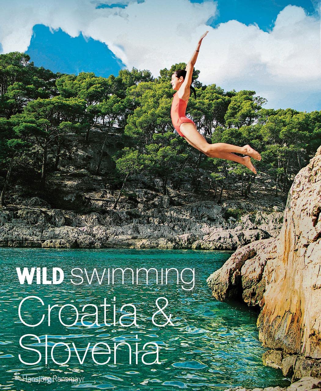
Bijzondere reisgids met unieke zwemlocaties in Kroatië en Slovenië. Korte informatie, routebeschrijvingen en vol met foto's!
Discover 120 of the most beautiful wild and hidden places to swim, from the Mediterranean coastline of Croatia to the mesmerizing mountain landscapes of Slovenia. Including secret coves, sea caves, rock arches, waterfall pools, aquamarine canyons and hidden lakes - many never before published. Lavishly illustrated, with 200 photos and 120 maps. The perfect guide for families on holidays or explorers looking for their next adventure.

€ 13.95
Wegenkaart - landkaart Amazon & Brazil North | ITMB

We first mapped the Amazon River Basin for a rainforest protection conference many years ago, preparing what we thought was a pretty good rendition until we arrived at a conference full of experts who were able to add so much more data that we re-did the map before publishing it. We have updated it repeatedly as more information has come to light and are pleased to release this sixth version, which does something that we have wanted to do for some time - it adds a detailed map of the northern half of Brazil/Brasil to a river map that covers portions of seven different countries. The map is printed on revolutionary stone paper (tear-resistant, waterproof, friendly to the environment, and bio-degradable as well as extremely durable), and has two different cover pictures, so it can be marketed either as a map of Brasil or of the Amazon Basin - or both! It is also the only map of the river basin in print. As the world emerges from the era of Covid, this part of the world will once again dominate demand for South American explorers.

€ 20.90
Reisgids Chalkidiki | Michael Müller Verlag

Uitstekende, diepgaande reisgids over dit deel van het land. Met veel achtergrondinformatie en ook praktische zaken als overnachtingen en eet- en drinkgelegenheden. Thematische hoofdstukken over geschiedenis, geologie etc. Let op: Duits!
Jede Menge Traumbuchten und Sandstrände, beste Wandermöglichkeiten auf Eselspfaden zwischen Steineichen und Olivenhainen und ein azurblaues Meer entlang der endlosen Küste: Dieses Handbuch bringt Sie zu den schönsten Fleckchen auf Chalkidiki.
Doch auch die Ausflüge in die Unterwelt bei Petralona sowie die besten Beispiele antiken Städtebaus in Olimbiada haben ihren besonderen Reiz. Neben den drei »Fingern« Kassandra, Sithonia und Athos hat Andreas Neumeier einen weiteren Schwerpunkt auf die zentralmakedonische Hauptstadt Thessaloniki gelegt. Ob Sie Wanderungen zu den Bergdörfern ins Hinterland bevorzugen, die historische Traumbucht mit dem versunkenen Hafen besichtigen wollen oder eine Mönchsrepublik besuchen, in der die Zeit stehengeblieben ist, ergibt sich aus eigenen Wünschen und Vorstellungen.
Auf 288 durchgehend farbigen Seiten, die eine Vielzahl praktischer Tipps und Hintergrundinformationen zur grünen Halbinsel im Nordosten Griechenlands bieten, werden Sie mit Sicherheit auf Ihre Kosten kommen!

€ 17.95
Wandelkaart Tour & Trail Rhodes - Rodos | Discovery Walking Guides

A large 960mm by 700mm double sided map sheet covers Rhodes at 1:50,000 scale and includes Chalki and Symi islets. On the cover side is Rhodes South with Chalki and Symi, with Rhodes North and street plans of Rhodes Town on the reverse. We have two street plans of the capital town.
 
Rhodes Town greater area is at 12k scale, including Acropolis in the west and spanning beyond Rodini park in the south. The other street plan shows the fortified Old Town in great detail at 5k scale. DWG's special concertina map fold makes our map easy to open and easy to refold to its 233mm by 120mm pocket size.
 
Our legendary 'Tour & Trail' level of detail ranges from major roads to secondary roads to minor roads to streets and narrow country roads, plus dirt roads, tracks and walking trails. Place names are in English and Greek to aid your navigation. Altitude shading is designed to clearly show the altitude range when travelling across the island by car or on foot.
 
20 metre and 100 metre contours combined with altitude shading bring this beautiful landscape to life. There are plenty of individual height points and all of the official 'Trig' points are on the map. Tour & Trail attention to detail includes our useful symbol range including viewpoints, picnic areas, petrol stations, bar/restaurants and parking areas where you can pull off the road safely.
 
You will easily identify springs, caves, sports grounds, cemeteries, monasteries, churches, chapels, lighthouses, castles, camping areas, wind turbines, windmills, hotels etc. Rhodes Compendium of Walking Adventures walking routes (all 98 walking routes) are specially highlighted on the map. It all adds up to the most detailed, most durable map of Rhodes, Chalki and Symi that you can buy anywhere.
 
'Super-Durable' means a waterproof, tear-proof, map that can take the roughest treatment and still folds up like new after your adventures. Super-Durable Maps come with a 2 year adventurous use 'Wear and Tear' guarantee.

€ 32.50
Reisgids Nord- und Mittel Griechenland | Michael Müller Verlag

Uitstekende, diepgaande reisgids over dit deel van het land. Met veel achtergrondinformatie en ook praktische zaken als overnachtingen en eet- en drinkgelegenheden. Thematische hoofdstukken over geschiedenis, geologie etc. Let op: Duits!
Mit den aktuellen Tipps aus den Michael-Müller-Reiseführern gestalten Sie Ihre Reise individuell, nachhaltig und sicher.
 
Spannend wie ein Lesebuch, informativ und detailliert wie ein Nachschlagewerk - so präsentiert sich das Reisebuchkonvolut "Nord- und Mittelgriechenland".
Die Autoren bieten ein buntes Potpourri aus Hintergrundinformationen, Geschichten über Land und Leute und vor allem wasserdichten Detailinformationen zu allem, was für den Griechenlandreisenden auf seiner Tour durch den nördlichen und mittleren Landesteil unverzichtbar ist: Hinweise zu Unterkünften, Restaurants, Tavernen, Einkaufstipps und natürlich jede Menge Infos zu Sehenswertem, Wandermöglichkeiten und zum Badevergnügen an endlosen Stränden und kleinen Buchten.
Vom Ionischen Meer bis zur Türkei, von Makedonien hinunter nach Athen und Attika und natürlich auch die vorgelagerten Inseln im Ionischen und Ägäischen Meer - nichts bleibt unberücksichtigt!

€ 7.95
Wegenkaart - landkaart National Park Pocket Map New Forest | Collins

Handige kleine kaart van dit Nationaal Park. De kaart geeft een goed en helder overzicht van het gebied met alle plaatsen, doorgaande wandelpaden (alhoewel grof van schaal), bezienswaardigheden etc. Met een register en aanvullende tekst onder de kaart is het een mooi overzicht wat je waar kunt gaan doen.
Handy little full colour map and guide of New Forest National Park. Detailed mapping and visitor information to the National Park along with a selection of photographs.
 
This small map with additional text and photographs gives a great overview of the New Forest National Park, and is the perfect companion for exploring this beautiful area of Southern England.
 
Clear, detailed mapping
Key park, tourist and travel information
Ideal for planning visits to the National Park
Index to help locate and plan your trip

€ 7.95
Wegenkaart - landkaart National Park Pocket Map Cairngorms | Collins

Handige kleine kaart van dit Nationaal Park. De kaart geeft een goed en helder overzicht van het gebied met alle plaatsen, doorgaande wandelpaden (alhoewel grof van schaal), bezienswaardigheden etc. Met een register en aanvullende tekst onder de kaart is het een mooi overzicht wat je waar kunt gaan doen.
Handy little full colour map of Cairngorms National Park. Detailed mapping and visitor information to the National Park along with a selection of photographs.The perfect way to explore this beautiful area in Scotland. This small map gives a great overview of the Cairngorms National Park.• Clear, detailed mapping• Key park, tourist and travel information• Ideal for planning visits to the National Park• Index to help locate and plan your trip

€ 8.95
Wandelkaart - Fietskaart 95 Bievre | NGI - Nationaal Geografisch Insti

Goede wandelkaart op basis van een topografische ondergrond. Deze toeristische wandelkaart is speciaal gemaakt met de plaats ongeveer in het midden en is daardoor uitstekend te gebruiken voor iedereen die de plaats of directe omgeving als uitvalsbasis heeft. Op de kaart zijn wandelroutes ingetekend, vaak met begeleidende tekst op de achterzijde. Ook bezienswaardigheden worden met symbolen aangeduid. 
 
Op deze kaart zijn ook Ravel fietsroutes en  VTT Mountainbike routes ingetekend.
 
Baillamont, Bellefontaine, Bièvre, Cornimont, Graide, Graide-Station, Gros-Fays, Monceau, Naomé, Oizy, Petit-Fays, Six-Planes.

€ 37.99
Reisverhaal Extreme Uitdagingen | Ronald Naar

Al bijna een halve eeuw beklimt de Nederlandse alpinist en expeditieleider Ronald Naar toppen over de hele wereld en schreef daarover in totaal zo'n veertien boeken, waarvan enkele bestsellers werden.
Zo beklom hij in 1995 de beroemde en vooral beruchte berg K2 in het Pakistaanse Karakorum-gebergte en deed daarvan verslag in Geen berg te hoog. Vier later ondernam hij een heel ander soort avontuur
door op ski's en met parasails de ijskap van Antarctica over te steken. Een tocht die na een zorgvuldige voorbereiding toch werd geconfronteerd met talrijke problemen. Dit verhaal over moed en
doorzettingsvermogen zette hij te boek in De plaag van de ijswind. In Extreme Uitdagingen zijn de beide prachtige en soms bloedstollende avonturenromans Geen berg te hoog en De plaag van de ijswind
gebundeld. Voor de echte Naar-fans is er bovendien een niet eerder gepubliceerde verhaal aan toegevoegd: Naars Duivelsei-expeditie, waarover De Telegraaf in 2005 nauwgezet verslag deed. Op zoek naar
nieuwe uitdagingen ontdekte de inmiddels vijftigjarige Naar een onbeklommen granietzuil in het hart van het Surinaamse regenwoud. Samen met twee jonge, talentvolle rotsklimmers, een journalist en
vier bosnegers trok hij zonder kaarten of moderne navigatie-apparatuur over rivieren en door de jungle, op zoek naar de ultieme prijs voor een alpinist: een berg waar nooit eerder iemand op heeft gestaan.
Behalve auteur en fotograaf is Ronald Naar ook een veelgevraagd spreker bij bedrijven en organisaties in binnen- en buitenland,waarbij thema¿s als succesvol teamwork, de noodzaak van continue
verandering en innovatie en inspirerend leiderschap centraal staan. Meer informatie over Ronald Naar en zijn activiteiten is te vinden op www.ronaldnaar.nl .

€ 11.50
Wandelgids Park Rangers Favourite Walks South Downs | Collins

Compacte wandelgids met 20 wandelingen geselecteerd door park rangers en met duidelijke beschrijvingen en routekaartjes.
 
Walking guide to the South Downs National Park, with 20 best routes chosen by the park rangers. Each walk varies in length from 2 to 10 km and can be completed in less than 4 hours.
 
20 best routes chosen and written by National Park rangers
 

Walks from 2 to 10km

Detailed description for each walk with highlights clearly marked on the map along with an accompanying map and photographs

General information about the National Park plus basic advice on walking

Abonneer op