€ 21.95
Reisgids Reise-Taschenbuch Extremadura | Dumont

Mooie, fraai ogende gids, handzaam formaat en toch redelijk uitgebreid over Extremadura. Deze serie reisgidsen zijn algemene reisgidsen en bevatten een brede selectie aan bezienswaardigheden, excursies, achtergronden, praktische tips en een uitneembare kaart.
Auf knapp 300 Seiten stellt das DuMont Reise-Taschenbuch alle sehenswerten Orte und Ausflugsziele in der Extremadura übersichtlich vor, Stadtspaziergänge, ungewöhnliche Entdeckungstouren und ausgewählte Wanderungen erschließen die Highlights und Besonderheiten der Region. Mit Lieblingsorten des Autors in Text und Bild, zahlreichen persönlichen Reisetipps, einem journalistischen Porträt der spanischen Region sowie einer separaten Reisekarte.

€ 9.95
Stadsplattegrond Berlin - Berlijn city map | Marco Polo

Een bijzonder handige stadsplattegrond van Berlijn, gedrukt op geplastificeerd papier waardoor deze kaart scheur- en watervast wordt. Met een plattegrond van het vliegveld en een uitgebereid register op de achterzijde. De kaart bestrijkt een groot gebied met een aantal voorsteden. Bezienswaardigheden zijn weergegeven.

€ 20.50
Fietsgids Europaradweg R1 deel 3: London - Münster | IS Radweg

Duitstalige beschrijving van een groot deel van de R1 van Londen tot aan Münster in Duitsland. Goede beschrijving met kaarten.
 
Nu de R1 voor het gedeelte door Frankrijk, Belgie, Nederland en dan tot aan Münster in Duitsland, totaal 760 km. Dit alles in een handige fietsgids in ringband. Zie afbeeldingen voor inhoud.
 

Der Radreiseführer beschreibt den Wegverlauf des Europaradweg R1 von London, via Dover/Calais nach Frankreich, durch Belgien und den Niederlanden nach Münster (915 Kilometer).

Der Wegverlauf zwischen Hoek von Holland (Niederlande) und Münster (395 Kilometer) ist identisch mit dem Weg des EuroVelo 2.


Der Radreiseführer bietet alles, was Sie für eine unbeschwerte Radfernwanderung auf dem R1/EV2  benötigen:


Karten/Wegskizzen 1:125.000 mit detaillierten Ortsdurchfahrten

diverse Zusatztouren, z.B. zur Strandpromenade Scheveningen

Weg- und Landesinformationen, Sehens- und Erlebenswertes

Höhenprofile, Tipps für die Touren- und Etappenplanung

Adressen und Links von Touristinformationen, Fahrradreparaturmöglichkeiten, Hotels, Pensionen und Zeltplätzen

sowie die Bahn- und Fährverbindungen mit An-/Abreisetipps nach/von London (mit Fernbus und Flugzeug)

Das ringgebundene Tourenbuch bietet die GPS-Tracks für den Originalweg und diversen zusätzlichen Wegen. 

Ferner gibt es digitale Wegpunkte (POI) von Übernachtungsmöglichkeiten, Touristinformationen, Sehenswürdigkeiten, Reparaturservices und Verkehrsanbindungen.

Diese Tracks und Wegpunkte (POI) sind nach Registrierung im Internet als Download in den Formaten .kml und .gpx erhältlich und können auf Outdoor-GPS-Geräte oder Smartphones überspielt unterwegs der Navigation dienen.

€ 28.95
Kinderwereldkaart 91ML Wereldkaart voor kinderen | Druckbunt

Geïllustreerde wereldkaart voor kinderen van ongeveer 5 tot 10 jaar met in de rand de vlaggen van alle landen en heel veel educatieve items over de gehele wereld: dieren, (historische) personen, bijzondere gebouwen, schepen en gebergten die met nummertjes naar de index verwijzen. Inclusief handige metalen strips om de kaart makkelijker op te kunnen hangen.

€ 23.95
Reisgids Panama | Lonely Planet

De perfecte reisgids voor zowel de georganiseerde als de zelfstandige reiziger. Naast een algemene inleiding van het land / streek vol met praktische informatie over hoe je er het beste kunt reizen: slapen, eten, vervoer, excursies ... alles kun je er in vinden. Engelstalig. Lonely Planet
From clear turquoise seas to the coffee farms and cloud forests of Chiriquí, Panama can be as chilled out or as thrilling as you wish. Lonely Planet will get you to the heart of Panama, with amazing travel experiences and the best planning advice.
 
Lonely Planet Panama is your passport to the most relevant, up-to-date advice on what to see and skip, and what hidden discoveries await you. Sip coconuts on a Caribbean beach; lay eyes on the awe-inspiring Panama Canal; or hike through sublime cloud forests; all with your trusted travel companion. Get to the heart of Panama and begin your journey now! 
 
Inside Lonely Planet Panama:

Color maps and images throughout

Highlights and itineraries help you tailor your trip to your personal needs and interests

Insider tips to save time and money and get around like a local, avoiding crowds and trouble spots

Essential info at your fingertips - hours of operation, phone numbers, websites, transit tips, prices

Honest reviews for all budgets - eating, sleeping, sight-seeing, going out, shopping, hidden gems that most guidebooks miss

Cultural insights give you a richer, more rewarding travel experience - land & wildlife, music, cuisine, arts, politics, history

Over 46 maps
 
Covers: Panama City, Panama Province, Cocle Province, Peninsula deAzuero, Veraguas Province, Chiriqui Province, Bocas del Toro Province, Colon Province, Comarca de Kuna Yala, Darién Province and more

€ 18.50
Reisgids Culture Shock! Philippines | Marshall Cavendish

CultureShock! Philippines is a survival guide for anyone living, working or wanting to discover life in the Philippines. Settling into a foreign land is never easy, but with this book you will learn to understand the importance of amor-propio, appreciate the Filipino ways and learn about the history and culture of this diverse country. Find out the importance of family to the Filipinos, how to communicate with the locals and learn the appropriate business etiquette. Packed with a resource guide, glossary, contact numbers, website addresses and useful advice, CultureShock! Philippines is essential for anyone wanting to fit in and enjoy life in the Philippines. 
 
About the Series 
 
The CultureShock! series is a dynamic and indispensable range of guides for those travellers who are looking to truly understand the countries they are visiting. Each title explains the customs, traditions, social and business etiquette in a lively and informative style. 
 
CultureShock! authors, all of whom have experienced the joys and pitfalls of cultural adaptation, are ideally placed to provide warm and helpful advice to those who seek to integrate seamlessly into diverse cultures.   
 
Each CultureShock! book contains:
insights into local culture and traditions
advice on adapting into the local environment
linguistic help, and most importantly
how to get the most out of your travel experience

€ 9.95
Stadsplattegrond City map Barcelona | Lonely Planet

De stadsplattegronden van Lonely Planet zijn uitgevoerd op scheur- en watervast papier, zijn lichtgewicht en kennen een handig formaat. Het centrum van de stad is in heldere kleuren in beeld gebracht met straatnamen, bezienswaardigheden en symbolen voor openbaar vervoer. Op de achterzijde staat informatie over de toeristische hoogtepunten en in de meeste gevallen een schematische plattegrond van het openbaar vervoer. Met een register.

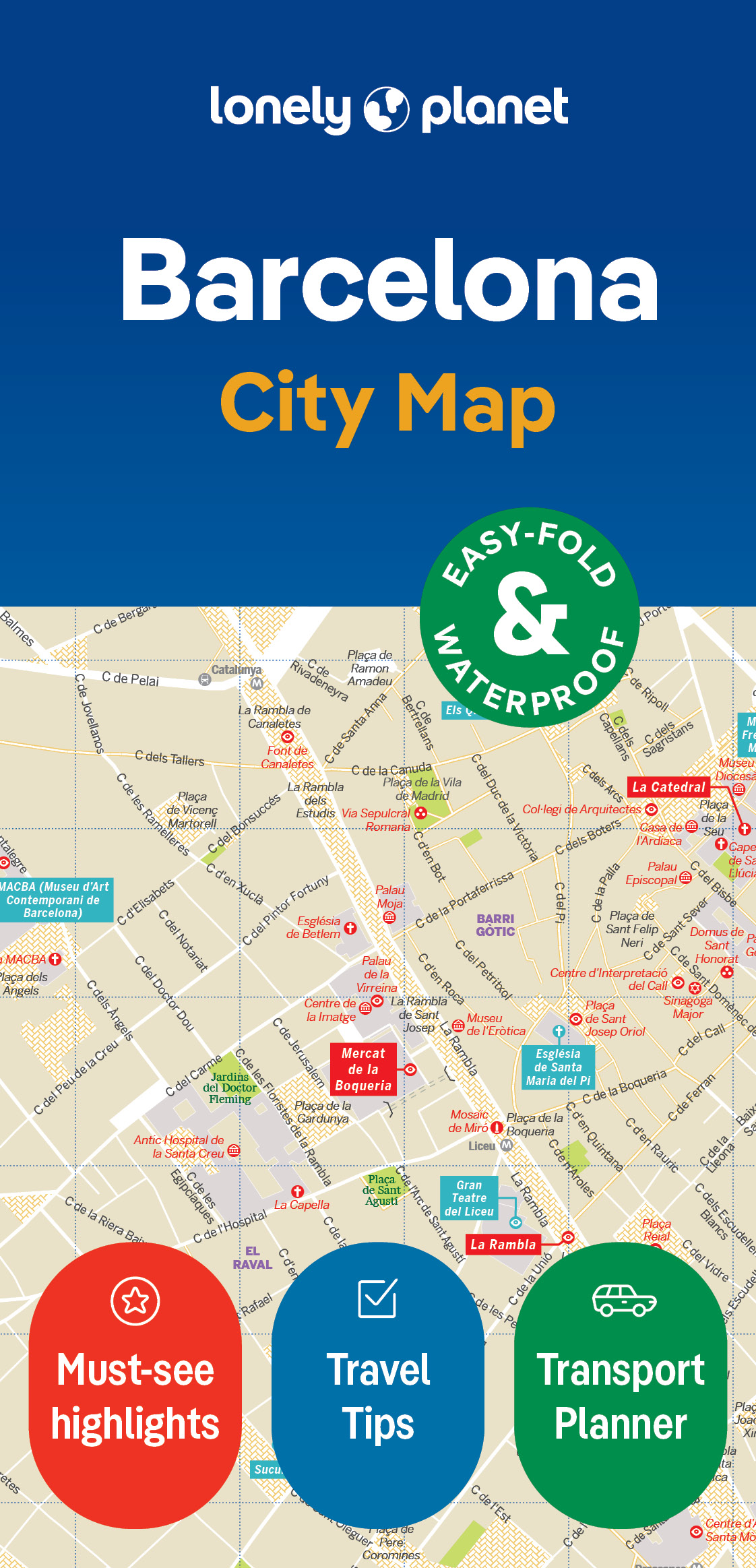
Durable and waterproof, with a handy slipcase and an easy-fold format, Lonely Planet's Barcelona City Map is your conveniently sized passport to travelling with ease. Get more from your map and your trip with images and information about top city attractions, walking tour routes, transport maps, itinerary suggestions, an extensive street and site index, and practical travel tips and directory. With this easy-to-use, full-colour navigation tool in your back pocket, you can truly get to the heart of Barcelona, so begin your journey now!Durable and waterproofEasy-fold format and convenient sizeHandy slipcaseFull colour and easy to useExtensive street and site indexImages and information about top city attractionsHandy transport mapsWalking tour routesPractical travel tips and directoryItinerary suggestionsCovers L'Eixample, Barri Gotic, La Ribera, Ciutat Vella, El Fort Pienc, Vila Olimpica, La Barceloneta, Port Vell, El Raval, Sant Antoni, Poble Sec, MontjuicLooking for more extensive coverage? Check out Lonely Planet's Barcelona, our most comprehensive guidebook to the city, covering the top sights and most authentic offbeat experiences.


Or check out Lonely Planet's Pocket Barcelona, a handy-sized guide focused on the can't-miss experiences for a quick trip. About Lonely Planet: Lonely Planet is a leading travel media company, providing both inspiring and trustworthy information for every kind of traveller since 1973. Over the past four decades, we've printed over 145 million guidebooks and phrasebooks for 120 languages, and grown a dedicated, passionate global community of travellers.


You'll also find our content online, and in mobile apps, videos, 14 languages, armchair and lifestyle books, ebooks, and more, enabling you to explore every day. 'Lonely Planet guides are, quite simply, like no other.'  New York Times'Lonely Planet. It's on everyone's bookshelves; it's in every traveller's hands.
Get more from your map and your trip with images and information about top city attractions, transport maps, itinerary suggestions, extensive street and site index, and practical travel tips and directory. With this easy-to-use, full colour navigation tool in your back pocket, you can truly get to the heart of Barcelona, so begin your journey now!

Durable and waterproof

Easy-fold format and convenient size

Handy slipcase

Full colour and  easy-to-use

Extensive street and site index

Images and information about top city attractions

Handy transport maps

Practical travel tips and directory

Itinerary suggestions

Covers L’Eixample, Barri Gotic, La Ribera, Ciutat Vella, El Fort Pienc, Vila Olimpica, La Barceloneta, Port Vell, El Raval, Sant Antoni, Poble Sec, Montjuic

€ 13.95
Reisgids Rough Guide Pocket Paris - Parijs | Rough Guides

Een kleinere versie in zakformaat van de grotere versies van de Rough Guides. Als altijd weer vol met goede informatie over cultuur en praktische zaken. Achterin een kaart van de stad.
This compact, pocket-sized Paris travel guidebook is ideal for travellers on shorter trips and those trying to make the most of Paris. It's light, easily portable and comes equipped with a pull-out map. This Paris guidebook covers: The Islands, The Louvre, The Champs-Elysees and Tuileries, the Eiffel Tower, Grands Boulevards, Beaubourg and Les Halles, the Marias, Bastille, Bercy, Quartier Latin, St Germain, Montparnasse, Montmartre, Northeastern Paris, Bois de Boulogne, Day-trips.
 
Inside this Paris travel book you will find:- Curated recommendations of places - main attractions, off-the-beaten-track adventures, child-friendly family activities, chilled-out breaks in popular tourist areas - Things not to miss in Paris - Eiffel Tower, Notre-dame, Parc Rives de Seine, Place des Vosges, Sainte-Chapelle, Musee Picasso, Musee d'Orsay, Jardin du Luxembourg, Centre Pompidou, Pere-Lachaise, Musee Rodin, Louvre, Haut Marais, Fondation Louis Vuitton, Passages - Ready-made itineraries samples - created for different time frames or types of trip- Paris at a glance - an overview map of Paris with key areas and short descriptions of what you'll find there- Day trips - extra information for those on longer breaks or wanting to venture further afield- Practical travel tips - information on how to get there and around, health guidance, tourist information, festivals and events, plus an A-Z directory- Handy language section - themed basic vocabulary for greetings, numbers and food and drink- Independent reviews - honest descriptions of places to eat, drink or stay, written by our expert authors- Accommodation - handy reference guide to a range of hotels for different budgets - Pull-out map - easy to extract folded map with places to see marked- What's new - a short overview of the changes in Paris in recent years for repeat travellers- Free download of the eBook - available after purchase of the printed Paris guidebook - Fully updated post-COVID-19The guide is a perfect companion both ahead of your trip and on the ground. It gives you a distinct taste of Paris with a concise edit of all the information you'll need.

€ 9.95
Wandelkaart 1 Pocketmap Triglav | Kartografija

Kleine handzame kaart van een deel van de Julische Alpen en omliggende gebieden. Opgevouwen heeft deze een formaat van 10 x 5 cm en uitgevouwen 55 x 52 cm. Op de achterzijde staat toeristische informatie in o.a. het Engels. 
Op de kaart zelf, met een schaal van 1:25.000, staan wandelroutes, fietsroutes, bezienswaardigheden, accommodaties en nationale parken goed ingetekend. Campings en berghutten ontbreken niet.

€ 15.95
Wandelkaart 40 Isola d'Elba | L'Escursionista editore

Voor weinig gebieden in Italië zijn echt goede wandelkaarten beschikbaar. Dit is gelukkig zo'n serie.
 
Met GPS grid uitgeruste detailkaart, schaal 1:25.000 met alle noodzakelijke wandelinformatie als ingetekende routes, Via Ferrata routes, campings, berghutten en schuilhutten, dat alles met een kaart die veel topografische details kent. 
 
Hoogtelijnen van 25 m. interval, schaduwtekeningen en goed gebruik van kleur voor bijvoorbeeld gletsjers en bossen. Naast ingetekende routes zijn er ook gewone voetpaden op te vinden. 
 
Bijgeleverd wordt (niet bij elke kaart) een kleine brochure met wandelmogelijkheden in dat bepaalde gebied

Abonneer op