€ 19.95
Reisgids Cornwall | Time Out

Escape to Cornwall with the Time Out Cornwall guide and uncover the best this wonderful county has to offer. We've used our local knowledge to reveal the best of the county and while we've included all the big attractions, we've gone beneath the surface to uncover plenty of small or hidden treasures too. With miles of magnificent coastline, hidden coves, walks and cycle trails galore, wonderful wildlife, exquisite towns and villages and a vibrant food scene, historic houses and gardens aplenty, Time Out Cornwall will help you uncover the best of this beautiful region.
 
About the Time Out Cornwall guide:Grouped by region - all the information for each region is grouped together so you can easily plan your day, weekend or short breakDetailed overview map of each region - each region is illustrated with a super-clear map so you can start to plan your routeBeautiful photographs - be inspired by all the amazing sights with these gorgeous photos that bring the region to life before you've even left homePacked with recommendations - discover the best places to eat and drink, where to stay, what to see and do while you're in that regionCultural connections - discover Port Isaac where Doc Martin was filmed, walk in the footsteps of Poldark and immerse yourself in the landscapes of Daphne du Maurier plus so many more iconic locationsHandy thematic index - here you can see at-a glance all the attractions grouped by theme so if your interest is sandy beaches, seafood, stately homes or surfing, you can quickly access the activities to suit you So, maybe it's your first time to Cornwall, maybe you haven't had a chance sift through hundreds of reviews online or get advice from your friends. No worries. Your Time Out guide to Cornwall is here to help.
 
With all the key information neatly put together in this handy, pocket sized guide, you're good to go
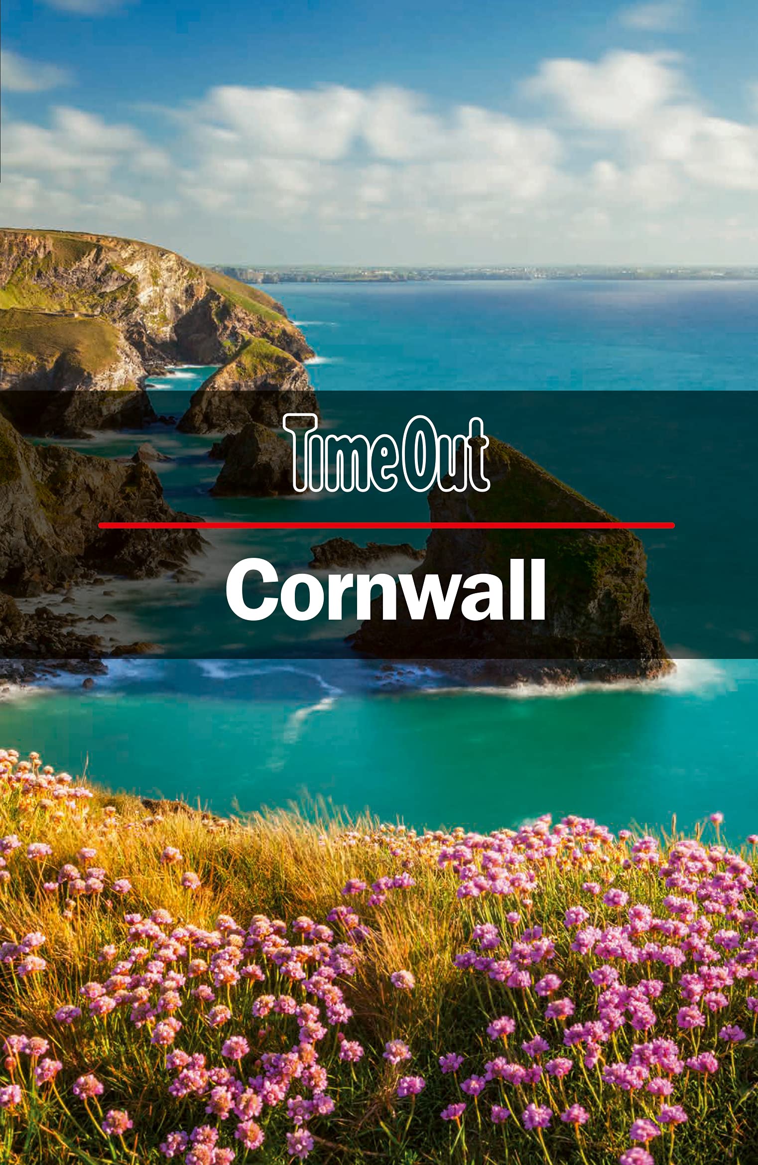
€ 21.50
Fietsgids Fietsen naar Berlijn | ReCreatief Fietsen

Handige fietsgids in ringband, past uitstekend in een stuurtas. Als vanouds van deze uitgever een gedegen gids met veel informatie, goed kaartmateriaal en een uitstekend beschreven route.
‘Fietsen naar Berlijn’ met een compleet nieuwe route, die vanaf Enschede of Coevorden via het Teutoburgerwoud, Hamelen, Braunschweig, Brandenburg en Potsdam naar Berlijn loopt. Onderweg worden andere bekende fietsroutes gekruist, zoals de R1 naar Polen en de Baltische Staten, de Hanzefietsroute, de Weserradweg, de Elberadweg en de IJzeren Gordijnroute (Eurovelo 3).
 
De Fietsroute
‘Fietsen naar Berlijn’ is een route met veel landschappelijke afwisseling, een route die cultuurhistorische hoogtepunten en fraaie binnensteden niet links laat liggen maar juist opzoekt, een route die geen gebrek heeft aan kampeermogelijkheden en die ook in stedelijke gebieden zo min mogelijk langs drukke wegen loopt. Zelfs in Berlijn is de route opvallend groen en grotendeels autovrij door gebruik te maken van nieuwe vrijliggende fietspaden en groenstroken die er na de val van de Muur zijn gekomen.
 
Afstand
De hoofdroute is 740 km lang en gaat over rustige wegen en paden. Zo’n 300 km is autovrij en 90 km is onverhard. In het Teutoburgerwoud, het Lipper Bergland, het Weserbergland en het Hildesheimer Wald zijn wat klimmetjes, die nooit lang duren. Voorbij Hildesheim is de route grotendeels vlak.
 
De Fietsgids
Deze goed verzorgde routegids is volledig in kleur, voorzien van heldere kaarten met een schaal van 1:150.000 en ruim geïllustreerd met foto's. Naast de routebeschrijving geeft de gids veel informatie over het ontstaan van de verschillende landschappen en de rijke cultuurhistorie langs de route, tips voor fietsers die ook met de trein willen reizen, handige internetadressen, een overzicht van kampeermogelijkheden en links naar websites waar allerlei overnachtingsmogelijkheden te vinden en te boeken zijn.

€ 7.95
Stadsplattegrond Popout Map Amsterdam | Compass Maps

Handig ( borstzak- ) formaat stadsplattegrond met voldoende detail, zodat je ook de kleinere straatjes erop aantreft. Van veel wereldsteden inmidddels leverbaar en dat is mooi, want juist in dit soort steden wil je je handen liever vrij houden en niet teveel hoeven stoeien met het uitvouwen van een grote plattegrond, en/of teveel als "toerist" opvallen. Door het unieke vouwsysteem blijft alles zeer compact en biedt het kaartje een razendvlugge manier van orientatie. Wel is dit product alleen geschikt voor het ( grote ) centrum van de stad.Verder geven de kaartjes uit deze reeks ook de meeste highlights van de stad aan en ( indien van toepassing ) een overzichtskaartje van de metro.
Explore vibrant Amsterdam, known as the 'Venice of the North', with this handy, genuinely pocket-sized, pop-up map. Small in size, yet big on detail, this compact, dependable Amsterdam city map will ensure you don't miss a thing. * Includes two pop-up maps covering historic Amsterdam & the city centre * Additional maps covering the museum quarter, transit system and a locator map are also included * Handy, self-folding tourist map is small enough to fit in your pocket yet offers extensive coverage of the city in an easy-to-use format * Thorough street index is also featured and cross-referenced to the map so you can easily find your destination * Hotels, restaurants, stores and attractions are all includedIdeal to pop in a pocket or bag for quick reference while you explore Amsterdam. Contents include maps of: Historic Amsterdam City Centre Museum Quarter Amsterdam transit Locator map Fold size: 3.75" x 5.25" (95mm x 130mm) Sheet size: 8.5" x 9.75" (215mm x 225mm) (per sheet; 2 sheets) Approx scale: 1:13 500 (Central) Scale to be used as a guideline only

€ 7.95
Stadsplattegrond Popout Map Brussels - Brussel | Compass Maps

Handig ( borstzak- ) formaat stadsplattegrond met voldoende detail, zodat je ook de kleinere straatjes erop aantreft. Van veel wereldsteden inmidddels leverbaar en dat is mooi, want juist in dit soort steden wil je je handen liever vrij houden en niet teveel hoeven stoeien met het uitvouwen van een grote plattegrond, en/of teveel als "toerist" opvallen. Door het unieke vouwsysteem blijft alles zeer compact en biedt het kaartje een razendvlugge manier van orientatie. Wel is dit product alleen geschikt voor het ( grote ) centrum van de stad.Verder geven de kaartjes uit deze reeks ook de meeste highlights van de stad aan en ( indien van toepassing ) een overzichtskaartje van de metro.
Explore the delights of the Belgian capital, Brussels, with the help of this genuinely pocket-sized, pop-up map. Small in size, yet big on detail, this compact, dependable Brussels city map will ensure you don't miss a thing.* Includes two pop-up maps covering central Brussels & greater Brussels Grand-Place (the heart of Brussels) * Additional maps covering Grand-Place (the heart of Brussels), Heysel Exhibition Park & Royal Castle of Laeken and the Metro are also included * Handy, self-folding tourist map is small enough to fit in your pocket yet offers extensive coverage of the city in an easy-to-use format * Thorough street index is also featured and cross-referenced to the map so you can easily find your destination * Hotels, restaurants, stores and attractions are all includedIdeal to pop in a pocket or bag for quick reference while exploring the city. Fold size: 3.75" x 5.25" (95mm x 130mm) Sheet size: 8.5" x 9.75" (215mm x 225mm)(per sheet; 2 sheets) Approx scale: 1:12000 Central Brussels Scale to be used as a guideline only. Contents include maps of: PopOut Map of greater Brussels PopOut Map of central Brussels Map of Grand-Place - the heart of Brussels Heysel Exhibition Park & Royal Castle of Laeken Metro

€ 7.95
Stadsplattegrond Popout Map Zurich | Compass Maps

Handig ( borstzak- ) formaat stadsplattegrond met voldoende detail, zodat je ook de kleiner straatjes erop aantreft. Van veel wereldsteden inmidddels leverbaar en dat is mooi, want juist in dit soort steden wil je je handen liever vrij houden en niet teveel hoeven stoeien met het uitvouwen van een grote plattegrond, en/of teveel als "toerist" opvallen. Door het unieke vouwsysteem blijft alles zeer compact en biedt het kaartje een razendvlugge manier van orientatie. Wel is dit product alleen geschikt voor het ( grote ) centrum van de stad.Verder geven de kaartjes uit deze reeks ook de meeste highlights van de stad aan en ( indien van toepassing ) een overzichtskaartje van de metro.
Handy, pocket-size, pop-up Zurich map. Ideal to pop in a pocket or handbag for quick reference while exploring the city.Explore Zurich with ease with the help of this genuinely pocket-sized, pop-up map. Small in size yet big on detail, this compact, dependable, city map will ensure you don't miss a thing. * Includes 2 PopOut maps: an overview of the greater city area and a detailed street map of central Zurich* Additional maps of the area surrounding Zurich and the transport system are also included* Handy, self-folding, tourist map is small enough to fit in your pocket yet offers extensive coverage of the city in an easy-to-use format* Thorough street index is also featured and cross-referenced to the map so you can easily find your destination* Hotels, restaurants, stores and attractions are all included on the map Fold size: 3.75" x 5.25"Sheet size: 8.5" x 9.75" (per sheet; 2 sheets)

€ 8.95
Stadsplattegrond Popout Map Geneva - Geneve | Compass Maps

Handig ( borstzak- ) formaat stadsplattegrond met voldoende detail, zodat je ook de kleinere straatjes erop aantreft. Van veel wereldsteden inmidddels leverbaar en dat is mooi, want juist in dit soort steden wil je je handen liever vrij houden en niet teveel hoeven stoeien met het uitvouwen van een grote plattegrond, en/of teveel als "toerist" opvallen. Door het unieke vouwsysteem blijft alles zeer compact en biedt het kaartje een razendvlugge manier van orientatie. Wel is dit product alleen geschikt voor het ( grote ) centrum van de stad.Verder geven de kaartjes uit deze reeks ook de meeste highlights van de stad aan en ( indien van toepassing ) een overzichtskaartje van de metro.
Let PopOut Geneva guide you around this wonderful city.
 
Discover the lakeside beauty of Geneva with ease with the help of this genuinely pocket-sized, pop-up map. Small in size yet big on detail, this compact, dependable, Geneva city map will ensure you don't miss a thing.
 
* Includes 2 PopOut maps - a detailed street map of central Geneva and a street map of the greater city area
* Additional maps of the area surrounding Lake Geneva and a Transit Map are also included
* Handy, self-folding, tourist map is small enough to fit in your pocket yet offers extensive coverage of the city in an easy-to-use format
* Thorough street index is also featured and cross-referenced to the map so you can easily find your destination
* Hotels, restaurants, stores and attractions are all included on the maps
 
Ideal to pop in a pocket or bag for quick reference while exploring the city.

€ 7.95
Stadsplattegrond Popout Map York | Compass Maps

Handig ( borstzak- ) formaat stadsplattegrond met voldoende detail, zodat je ook de kleinere straatjes erop aantreft. Van veel wereldsteden inmidddels leverbaar en dat is mooi, want juist in dit soort steden wil je je handen liever vrij houden en niet teveel hoeven stoeien met het uitvouwen van een grote plattegrond, en/of teveel als "toerist" opvallen. Door het unieke vouwsysteem blijft alles zeer compact en biedt het kaartje een razendvlugge manier van orientatie. Wel is dit product alleen geschikt voor het ( grote ) centrum van de stad.Verder geven de kaartjes uit deze reeks ook de meeste highlights van de stad aan en ( indien van toepassing ) een overzichtskaartje van de metro.
 

Let PopOut York guide you around this wonderful city.


Get to the heart of the historic walled city of York with the help of this genuinely pocket-sized, pop-up map. Small in size yet big on detail, this compact, dependable, York city map will ensure you don't miss a thing.


Includes a PopOut map - a detailed street map of the city centre

Advice on the top things to see while you’re there

Handy, self-folding, tourist map is small enough to fit in your pocket yet offers extensive coverage of the city in an easy-to-use format

Thorough street index is also featured and cross-referenced to the map so you can easily find your destination

Hotels, restaurants, stores and attractions are all included on the map


Ideal to pop in a pocket or bag for quick reference while exploring this gorgeous city.

€ 19.95
Reisgids Hallo! New York | Hey! USA

Ontdek New York als een échte New Yorker
 
Weg met de saaie reisgidsen... Hallo! New York!  Met deze gids ontdek je New York op een andere manier. Bomvol inspiratie, informatie en nuttige tips. Veel foto’s én een handige gratis app!
 
Passie voor New York! Dit ‘knip en plak schrift’ is jouw gids naar de verborgen pareltjes in de Big Apple die nog niet eerder in andere gidsen te vinden waren!
 
Visuele gids, veel foto's!
Hidden gems & hotspots
Tips, tricks & must-do's
Wandelingen & dagplannen
Gratis app!
4 minimagazines

€ 39.99
Reisfotografiegids Het grote Reisfotografie boek | Van Duuren Media

Reisfotografie is misschien wel de discipline waar je als fotograaf het meest veelzijdig voor moet zijn. Je combineert fotografie van adembenemende landschappen met macrofoto’s van exotische dieren en portretten van de interessante lokale bevolking. Je moet op het juiste moment op de juiste plek zijn en ook nog eens alle juiste apparatuur bij je hebben. Hoe doe je dat allemaal?
 
Of je nu op een speciale fotoreis bent of een familievakantie: je wilt thuiskomen met een verzameling geweldige foto’s die de lading van jouw reis dekken. Ben je het beu om reisfoto’s te maken die er ‘prima’ uitzien en wil jij je vrienden eindelijk eens omverblazen met jouw fotografie? Dan biedt Scott Kelby je de oplossing!
 
Het grote reisfotografieboek is geen theorieboek vol verwarrend jargon en gedetailleerde concepten. Daar zit je niet op te wachten. In dit boek vertelt topfotograaf Scott Kelby je precies in welke situatie je welke instelling moet gebruiken en welke knop je moet indrukken. Scott beantwoordt je vragen, geeft je advies en deelt de fotografiegeheimen die hij heeft geleerd, zonder de onnodige technische uitleg en diagrammen.
 
Het boek bevat 200 prachtige foto’s waarbij Scott Kelby je telkens uitlegt hoe hij die foto heeft gemaakt en hoe jij dat ook kunt doen. Zo zorg je er samen voor dat jouw reisfoto’s zo mooi, levendig, meeslepend en professioneel worden, dat toeschouwers zich meteen op de plek van bestemming wanen

€ 7.95
Wegenkaart - landkaart National Park Pocket Map Lake District | Collin

Handige kleine kaart van dit Nationaal Park. De kaart geeft een goed en helder overzicht van het gebied met alle plaatsen, doorgaande wandelpaden (alhoewel grof van schaal), bezienswaardigheden etc. Met een register en aanvullende tekst onder de kaart is het een mooi overzicht wat je waar kunt gaan doen.
 
Handy little full colour map and guide of Lake District National Park. Detailed mapping and visitor information to the National Park along with a selection of photographs.
 
This small map with additional text and photographs gives a great overview of the Lake District National Park, and is the perfect companion for exploring this beautiful area of Northern England.
 

Clear, detailed mapping

Key park, tourist and travel information

Ideal for planning visits to the National Park

Index to help locate and plan your trip

Abonneer op