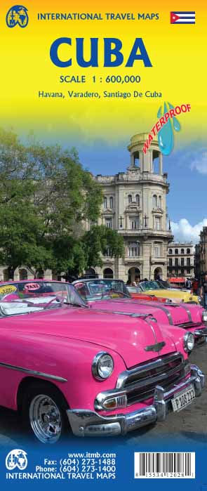
€ 13.95
Reisgids Rough Guide Pocket Madrid | Rough Guides

Een kleinere versie in zakformaat van de grotere versies van de Rough Guides. Als altijd weer vol met goede informatie over cultuur en praktische zaken. Achterin een kaart van de stad.


This compact, pocket-sized Madrid travel guidebook is ideal for travellers on shorter trips and those trying to make the most of Madrid. It's light, easily portable and comes equipped with a pull-out map.


This Madrid guidebook covers: Madrid de los Austrias, Palacio Real and Ópera, Rastro, Lavapiés and Embajadores, Sol, Santa Ana and Huertas, Paseo del Arte and Retiro, Gran Vía, Chueca and Malasaña, Salamanca and Paseo de la Castellana, Plaza de España and beyond.


Inside this Madrid travel book you will find:


- Curated recommendations of places - main attractions, off-the-beaten-track adventures, child-friendly family activities, chilled-out breaks in popular tourist areas

- Things not to miss in Madrid - Museo Thyssen-Bornemisza, Tapas, Museo del Prado, Estadio Santiago Bernabéu, Museo Reina Sofía, Clubbing, Palacio Real, Plaza Mayor, Museo Arqueológico Nacional, Museo Sorolla, The Retiro, Café culture, Madrid specialities, Segovia, Flamenco, Eating alfresco, Jardines Botánicos

- Ready-made itineraries samples - created for different time frames or types of trip

- Madrid at a glance - an overview map of Madrid with key areas and short descriptions of what you'll find there

- Day trips - extra information for those on longer breaks or wanting to venture further afield

- Practical travel tips - information on how to get there and around, health guidance, tourist information, festivals and events, plus an A-Z directory

- Handy language section - themed basic vocabulary for greetings, numbers and food and drink

- Independent reviews - honest descriptions of places to eat, drink or stay, written by our expert authors

- Accommodation - handy reference guide to a range of hotels for different budgets

- Pull-out map - easy to extract folded map with places to see marked

- What's new - a short overview of the changes in Madrid in recent years for repeat travellers

- Free download of the eBook - available after purchase of the printed Madrid guidebook

- Fully updated post-COVID-19


The guide is a perfect companion both ahead of your trip and on the ground. It gives you a distinct taste of Madrid with a concise edit of all the information you'll need.


€ 11.95
Wandelkaart 11.11/17 Frangokastelo - Plakias - Kreta | Anavasi

Uitstekende topografische kaarten van een deel van Griekenland: zonder meer hele goede kaarten voor wandeltochten in een onbekend stuk Griekenland! Ze zijn gedrukt op scheurvast en watervast papier op een schaal van

1:25.000 met een UTM grid voor GPS gebruikers.


Op de meeste kaarten is geven de hoogtelijnen een interval van 20m. aan. Met schaduwkleuren, punten met hoogtemeters, bronnen, riviertjes en landgebruik geven ze de topografie van het land goed weer.


Lokale voetpaden, herbergen en berghutten zijn duidelijk weergegeven. De wegen zijn in gradaties getekend: verhard en onverhard, groot en klein, met afstanden en benzinepompen.


Toeristische bezienswaardigheden als kloosters, grotten, kerken etc staan ingetekend. Achterop de kaart worden suggesties gegeven voor wandelroutes met wandeltijd in uren.


A new map on the eastern side of the White Mountains, adjacent to the map Sfakia – Pachnes, that extends from the Imbros gorge to the well-known resort of Plakias. On the southern side of this area, facing the Libyan sea, are a series of canyons, starting from the coast and reaching the higher slopes of Mt Angathes and Kryoneritis. A typical landscape of the Sfakia region with rough terrain and rocky, barren slopes. The northern side of these mountains is markedly different, with softer terrain, more vegetation and villages bearing influence of Venetian architecture. Dozens of hiking paths are recorded on the map, mainly in canyons as well as long crossings such as the E4 trail


€ 9.95
Stadsplattegrond Fleximap Copenhagen - Kopenhagen | Insight Guides

Geplastificeerde kaart van Kopenhagen, met register. Voor de 'gewone' toerist een handige kaart, geen groot formaat, overzichtelijk met alle belangrijke plaatsen goed weergegeven.


Flexi Map Copenhagen is a laminated, tear-resistant map which has 3 maps, each accompanied by its own index. 

It includes a list - with descriptions and some photographs - of 23 recommended sights, divided by theme and linked to the mapping by numbered markers. There is also a handy information section with concise details on getting around, tourist offices, money, tipping, opening times, public holidays, telecommunications, emergency telephone numbers and climate.


On the main map, shown at a scale of 1:11,000 (1cm = 0.110km), streets are named and a selection of hotels, public buildings and key sights are prominently marked, pedestrian areas and one-way systems are also shown. The comprehensive index is divided into categories for ease of use. A detailed Metro plan is located on the back cover for easy reference.


A Copenhagen area map can be found on the reverse and shows the various routes into the city by road and rail. Also included is a map of the wider area, shown at a scale of 1:300,000 (1cm =3km). In addition to the road and rail networks, it provides a picture of the region's topography through the use of relief shading. Intermediate distance indicators are given on the main routes.

€ 12.95
Wandelkaart - Fietskaart NP Torcal de Antequera | Editorial Penibetica

Een zeer uitgebreide wandel- en fietskaart van het nationale park Torcal of Antequera met een gidsje met beschreven wandelroutes van variërende lengte. Op de kaart worden hoogtelijnen, plaatselijke voorzieningen, wandel- en fietsroutesmeegenomen. GPS compatible.


two separate maps, both with a UTM grid and latitude/longitude margin ticks at 1' intervals, but no overprint for cycling routes. One map at 1:30,000 (68x77cm) is centred on the Laguna de Fuente de Piedra and extends to Alameda in the north-east to Campillos in the south west. A small inset shows the Lagunas de Archidona which lie further to the east. The other map at 1:25,000 (65x48cm) covers the Torcal de Antequera Natural Park and includes Villanueva de la Conception in the south and part of Antequera in the north. The booklet is in English.

€ 15.95
Wegenkaart - landkaart Yemen - Jemen | Gizi Map

Yemen, including the Gulf of Aden, at 1:1,250,000 on an excellent and informative map from Gizi Maps, with a street plan of central Sana’a and enlargements of the environs of the capital and Aden, plus the Aden Peninsula.


The map has the publisher’s characteristic bold altitude colouring and plenty of names of various mountain chains, peaks, deserts, etc. Graphics indicate swamps, salt flats, wadis, deserts, lava flows, water wells, oasis, etc, to provide a vivid picture of the country’s topography. Names of the larger towns, provinces and many geographical features are given in both Latin and Arabic alphabets; all other place names are shown only transliterated.


Coverage extends southward to the northern coastline of the Horn of Africa, including the whole of Djibouti and most of Eritrea. Within the Gulf of Aden the Internationally Recommended Transit Corridor (IRTC) is marked, as well as other ferry and shipping routes including those leading to the Socotra Archipelago and in the southern part of the Red Sea.


The map shows the country’s road network, including desert tracks, indicating distances on main routes and locations of border crossings to Oman and Saudi Arabia. Local airports are marked, as well as internal administrative boundaries with names of the provinces, plus oil or gas wells. Symbols highlight various places of tourist interest. The map has latitude and longitude lines at intervals of 1°. The index is next to the map. Map legend includes English.


Also provided are a street plan of central Sana’a, plus enlargements of the environs of the capital, the environs of Aden (Adan) area including Little Aden, and the Aden Peninsula itself. All are annotated with various facilities and places of interest.

€ 42.95
Wandkaart Zweden, 79 x 177 cm | Norstedts

Een grote kaart van Zweden voor aan de muur. Decoratieve kleuren tonen verschillende hoogten en Zweedse bergketens. Belangrijke wegen, spoorwegen en steden zijn duidelijk herkenbaar. 


Wordt geleverd op rol in stevige kartonnen koker.

€ 169.00
Wereldbol - Globe 17 Neon Classic ø 30 cm | Met Verlichting | National Geographic

Deze National Geographic Neon Blauw wereldbol is een van de favoriete globes voor scholen en hogere onderwijsinstellingen. Dit is te danken aan het neutrale, maar toch sierlijke uiterlijk van het product. Daarnaast is de globe, net als alle andere wereldbollen van National Geographic, zeer eenvoudig af te lezen dankzij het heldere kaartbeeld met een duidelijke aanduiding van politieke grenzen en bergen. De voet is gemaakt van stijlvol essenhout, de bol zal een ware eye-catcher zijn in ieder interieur.

€ 395.00
Prikbord 84PR Wereldkaart, politiek, 176 x 122 cm | National Geographic

Een bijzonder grote wereldkaart van National Geographic. Deze kaart is politiek van opbouw: alle landen worden met duidelijke grenzen heel goed zichtbaar. Daarnaast staan er veel plaatsen op en worden ook de dieptes van de verschillende oceanen, golfstromen en heersende windrichtingen weergegeven.


Een prachtige kaart aan de muur, aan de zijkanten afgewerkten met een mooie rand en een heldere maar tegelijk ook vrij zachte, niet overheersende kleurstelling.


De wandkaarten op prikbord worden geleverd met een aluminium lijst en een eenvoudig te monteren ophangsysteem. Zij zijn geschikt voor allerhande markeringsystemen als vlaggetjes en prikkers.


We leveren bij dit prikbord 1 set (20 stuks) gratis markeervlaggetjes. 


€ 145.00
Kinderwereldkaart 91H Wereldkaart voor kinderen | Druckbunt

Geïllustreerde wereldkaart voor kinderen van ongeveer 5 tot 10 jaar met in de rand de vlaggen van alle landen en heel veel educatieve items over de gehele wereld: dieren, (historische) personen, bijzondere gebouwen, schepen en gebergten die met nummertjes naar de index verwijzen.

De kaart is uitgevoerd met blank houten stokken aan de boven- en onderzijde en voorzien van een ophangtouw in de bovenste stok. Met een spijker of schroef is deze fraaie kaart dus eenvoudig aan de muur te hangen.

Let op! Door het plaatsen van de houten stokken vallen de vlaggen aan de boven- en onderkant helaas weg.

€ 19.99
Wandelgids Sardinië | Uitgeverij Elmar

De Rother Wandelgids Sardinië bevat 63 wandelingen voor dit prachtige Italiaanse eiland.

Al deze wandelingen zijn voorzien van betrouwbare routebeschrijvingen, gedetailleerde wandelkaarten en informatieve hoogteprofielen.


Alle hier beschreven wandelingen zijn niet al te moeilijk en volgen goed aangegeven routes. Ze kunnen meestal ook door minder goed getrainde wandelaars, en voor een deel ook met kinderen en ouderen, worden gemaakt.


De nauwkeurige routebeschrijvingen worden geïllustreerd met foto’s van het landschap een veelkleurige wandelkaartjes. Een handige en compacte wandelgids die zeker niet mag ontbreken bij uw wandelvakantie naar Sardinië.


Let op: er is enige verwarring omtrent het jaartal van deze Nederlandse wandelgidsen van uitgever Elmar. Dit is een vertaling van de Duitse uitgever Rother maar daarna NIET bijgewerkt. De datum die wij vermelden is het moment van vertaling; er zijn andere – meer recente jaartallen – in omloop maar dat is de datum van een nieuwe druk ZONDER aanpassingen. Wilt u de meest recente wandelgids van dit gebied van deze uitgever: kies dan de Duitstalige versie van uitgever Rother. Deze zijn recent en WEL bijgewerkt. 


Abonneer op