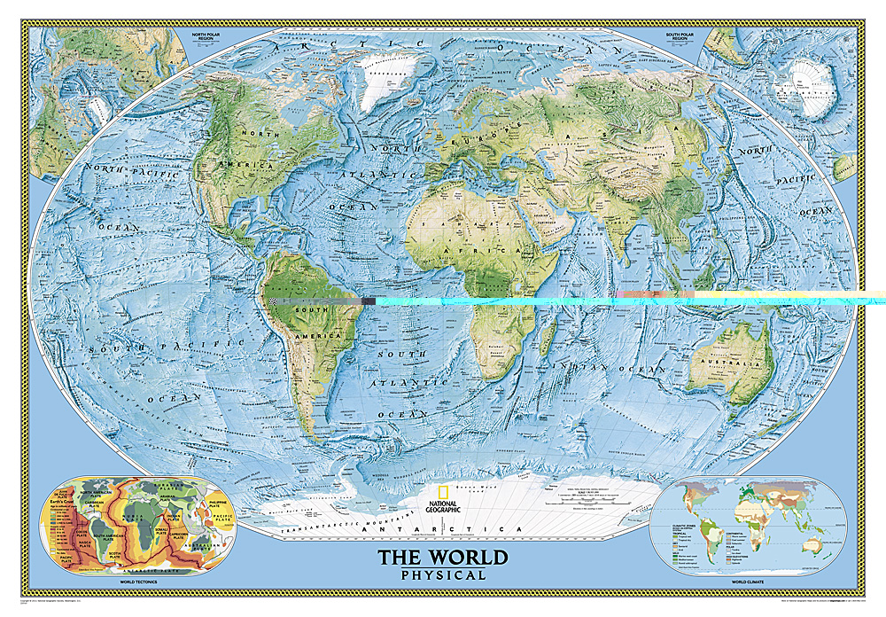
€ 21.95
Reisgids Reise-Taschenbuch Kos | Dumont

Fraai ogende gids, handzaam formaat en toch redelijk uitgebreid over Kos inclusief Níssyros, Kálymos , Léros, Lipsí en Pátmos. Deze serie reisgidsen zijn algemene reisgidsen en bevatten een brede selectie aan bezienswaardigheden, excursies, achtergronden, praktische tips en een uitneembare kaart.

Auf knapp 300 Seiten stellt das DuMont Reise-Taschenbuch die Inseln Kos, Níssyros, Kálymnos, Léros, Lipsí und Pátmos übersichtlich vor. Stadtspaziergänge, ungewöhnliche Entdeckungstouren und ausgewählte Wanderungen erschließen die Highlights und Besonderheiten der Inseln des Nord-Dodekanes. Mit Lieblingsorten des Autors in Text und Bild, zahlreichen persönlichen Reisetipps, einem journalistischen Porträt der Region sowie einer separaten Reisekarte.

€ 9.95
Wegenkaart - landkaart Mapa Provincial Cadiz | CNIG - Instituto Geográfico Nacional

Deze kaart is zuiver gericht op de provincie als in de titel. Gebieden naast de kaart worden zonder kleur weergegeven. Ideale kaart als het gaat om het onderscheid in topografische details als hoogte, nationale parken, vegetatie en plaatsen. Met schaduwrelief wordt hoogte goed zichtbaar. Zeker geschikt voor fietsers, al heb je er soms wel veel nodig.

Nadeel is het feit dat deze kaarten niet altijd even goed up-to-date zijn. Het komt soms wel voor dat bepaalde wegen inmiddels veel groter zijn geworden dan ingetekend op de kaart. Maar dan gaat het vooral om de grotere wegen: voor kleinere details is het een prima kaart.

One of the titles in a series of contoured road maps from Spain's civilian survey organisation, each covering one administrative province, excellent in presenting the country’s topography and locations of its many national and natural parks. The maps have contours at 100-metre intervals enhanced by relief shading, plus spot heights. Additional colouring is used to indicate various types of vegetation. Boundaries of national/natural parks are highlighted. Road network includes minor local roads and tracks, and motorways distinguish between free and toll routes. Railways show high speed, double, and single track lines. Unless indicated to the contrary in the individual descriptions, the maps have UTM grid, plus latitude and longitude margin ticks at 15' intervals, and an index of place names on the reverse. The legend is in Spanish only. Unlike in the older versions of this series, on each title all the information continues outside the provincial boundary, but without the relief shading and vegetation colouring.

€ 9.95
Wegenkaart - landkaart Mapa Provincial Girona | CNIG - Instituto Geográfico Nacional

Deze kaart is zuiver gericht op de provincie als in de titel. Gebieden naast de kaart worden zonder kleur weergegeven. Ideale kaart als het gaat om het onderscheid in topografische details als hoogte, nationale parken, vegetatie en plaatsen. Met schaduwrelief wordt hoogte goed zichtbaar. Zeker geschikt voor fietsers, al heb je er soms wel veel nodig.

Nadeel is het feit dat deze kaarten niet altijd even goed up-to-date zijn. Het komt soms wel voor dat bepaalde wegen inmiddels veel groter zijn geworden dan ingetekend op de kaart. Maar dan gaat het vooral om de grotere wegen: voor kleinere details is het een prima kaart.

One of the titles in a series of contoured road maps from Spain's civilian survey organisation, each covering one administrative province, excellent in presenting the country’s topography and locations of its many national and natural parks. The maps have contours at 100-metre intervals enhanced by relief shading, plus spot heights. Additional colouring is used to indicate various types of vegetation. Boundaries of national/natural parks are highlighted. Road network includes minor local roads and tracks, and motorways distinguish between free and toll routes. Railways show high speed, double, and single track lines. Unless indicated to the contrary in the individual descriptions, the maps have UTM grid, plus latitude and longitude margin ticks at 15' intervals, and an index of place names on the reverse. The legend is in Spanish only. Unlike in the older versions of this series, on each title all the information continues outside the provincial boundary, but without the relief shading and vegetation colouring.

€ 11.50
Wegenkaart - landkaart Tasmanië - Tasmania (tweezijdig) | Hema Maps

Deze Tasmanie kaart is verschillend met de andere Tasmanie kaart: op deze kaart staat Tasmanie op de voor- en achterzijde, tweedelig dus!

Goede, overzichtelijke, leesbare kaart van het hele eiland. Nationale Parken zijn er goed op te vinden en de afstanden worden weergegeven. Op de achterkant nog deelkaartjes van enkele steden en NP s.

A compact map of Tasmania for touring throughout the state with a distance grid and index for planning and reference. Marked on the mapping are highways, major and minor roads, camping and rest areas, 24-hour fuel, information centres, picnic areas, caravan parks, and lookouts.


Key Features


• Camping areas


• Caravan Parks


• Fully indexed


• Easy to use

€ 22.50
Reisgids The tourist travel and field guide of the Serengeti National Park | Veronica Roodt

Veronica Roodt’s travel and field guide is consequently designed for nature loving tourists. The first section consists of a travel guide with information on how to get there, where to stay, road conditions, best season to visit and climate. It also includes detailed maps and background information on the history, people, topography, geology and archaeology.

The second part is a field guide that includes check lists and over 500 photographs of the plants, mammals, birds, reptiles and amphibians one is most likely to see. Read about the nutritional value and medicinal uses of plants, habitat preferences of large mammals as well as interesting animal and bird behaviour.

Maps included:

Road map of the Serengeti National Park
Map of Africa
Map of Tanzania
The Serengeti Ecosystem
Acess to the SNP
Topographical map
Lobo Area
Western Corridor / Kirawira
Seronera Area
Seronera Camping Sites
Short Grass Plains
Gol Kopjes
Lake Magadi
Moru Kopjes
Lake Ndutu
Lake Ndutu camp sites

€ 13.95
Wegenkaart - landkaart Vietnam - Laos - Cambodia | ITMB

Een degelijke kaart met aanduidingen van o.a. nationale parken, vliegveld, benzinepomp, dirt-roads. Als overzichtskaart goed te gebruiken.

The former French-dominated region of Indochina evolved into three separate countries in the early 1950s. Vietnam, Laos, and Cambodia still retain strong ties and it is easy to travel from one country to another. Each has its particular charm, with a Top Attractions list highlighting the most popular attractions. Side 1 concentrates on the southern portion of the region and includes an inset map of Ho Chi Minh City; the second side covers the area from Sien Riep in Cambodia to the Chinese border areas of both Laos and Vietnam. An inset map of Hanoi is one this side. The region is prospering after many years of civil unrest, is friendly, safe, and easy to reach since Covid restrictions were removed last year. The new Chinese-built rail line through northern Laos to Chiang Kong in Thailand, and to Vientiane, Laos, is shown for the first time. This line connects with the Chinese rail system leading to Yunnan, but is not shown as the route is still regarded as a military secret by China. At the moment, its purpose is to move freight from China to ports, but it is probable that passenger service is also possible. The map is printed on waterproof stone paper for durability and to hold up in extremely humid conditions.


Map size: 27*39"


Legend Includes:

Roads by classification, Rivers and Lakes, National Park, Airports, Points of Interests, Highways, Main Roads, Zoos, Fishing, and much more...

€ 12.75
Reisgids Handbook Kenya´s Beaches | Footprint

Handige en handzame reisgids van de kustlijn en stranden van Kenya.

Footprintfocus Kenya’s beaches is packed with information on some of Africa’s most beautiful beaches. From top-class beachside hotels to dense coastal forests, this guide will prove an invaluable companion.

Lie back and relax on some of Africa's most beautiful white sand beaches. When you get fed up of chilling out in the sun try something more adventurous; from diving to windsurfing, there’s a host of activities on offer. Kenya’s coastline has more than just beachside hotels however, as the homeland of Swahili culture this is a region with a unique identity. From the bustle of Mombasa to the wonder of Wasini Island, this Footprintfocus guide will prove an invaluable companion.

· Essentials section with tips on getting there and around.
· Background section with fascinating information on the region’s unique history and culture.
· Comprehensive listings of where to eat & sleep, including detailed information on beach resorts.
· Detailed street maps for Mombasa and other important towns.
· Slim enough to fit in your pocket.

Loaded with advice and information, this concise Footprintfocus guide will help you get the most out of Kenya’s beaches without weighing you down.

€ 17.95
Wandelgids Wandelen binnen de singels van Utrecht | Gegarandeerd Onregelmatig

Met een 2000 jaar oude historie en 1400 rijksmonumenten is Utrecht een van de meest monumentale steden van Nederland. Het gros daarvan ligt 'binnen de singels'. Deze gids laat u in zes wandelingen kennis maken met de historische binnenstad van Utrecht en zijn monumenten.

'Wandelen binnen de singels van Utrecht' is geschreven door Kees Volkers, omgevingshistoricus en Utrechtkenner. Hij maakte eerder (met Anton Rosmüller) de succesvolle gids 'Wandelen buiten de binnenstad van Utrecht'.

€ 14.50
Wegenkaart - landkaart België, Luxemburg | Hallwag

Zeer goede, gedetailleerde en up-to-date autokaart van België en Luxemburg. Met afstandentabel en uitgebreide legenda en index.

Hallwag road maps are renowned for their up-to-date information, clear layout and convenience. See for yourself the benefits of the Hallwag international map collection, with new ideas to make travel even easier.

The map also covers the north east of France. A range of symbols indicate information for tourists including: places of interests, viewpoints, natural curiosities, notable buildings and ruins, monuments, monasteries and churches, yearly and seasonal campsites, windmills, lighthouses and golf courses.

The map includes extensive transportation detail, multiple language information (English, German, Italian, and French), and a complete multiple language index. There are also inset maps showing more detail of the major cities. Relief shading clearly shows the topography of the land.

The map also includes Hallwag's Distoguide - the integrated mileage chart - on the outer map cover which is quick and easy to use and extremely practical for planning and travel. Simply read off more than 2000 distances on the sliding mileage chart integreated in the map cover.

€ 13.95
Stadsplattegrond Santiago & Northern Chile | ITMB

Een gedetailleerde stadsplattegrond van Santiago (1:12500) met een metro netwerkkaart, en een wegenkaart van Noord Chili (1:1.770.000).

A detailed street map of Santiago and a road map of Northern Chile. The best way to prepare your trip, to plan your itinerary, and to travel independently.

Touristic information: places of interest, national parks, World Heritage sites, museums, beaches, glaciers …

The legend is in English and in Spanish.

Abonneer op