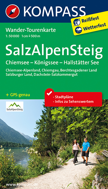
€ 14.50
Wandelkaart 154 Bozen und Umgebung - Bolzano e Dintorni | Kompass

Goede wandelkaart met vrijwel alle topografische details als hoogtelijnen, vegetatie, schaduwtekening maar ook de ingetekende wandelroutes en in veel gevallen ook fietsroutes (MTB). Gevaarlijke routes worden als zodanig weergegeven met een bepaalde markering. Berghutten en campings zijn goed terug te vinden op deze kaarten.


Daarnaast staan de toeristische bezienswaardigheden met symbolen vermeld. Kleurgebruik kan soms vrij fel overkomen, daardoor oogt deze detailkaart wellicht wat druk, maar het blijft een goed leesbare kaart. Sommige kaarten zijn geplastificeerd, maar helaas niet allemaal. De graden staan aan de zijkanten van de kaart, daardoor te gebruiken voor GPS.


Steden/dorpen/gebieden:

Mölten (Meltina), Sarnthein (Sarentino), Barbian (Barbiano), Jenesien (S. Genesio A.), Terlan (Terlano), Ritten (Renon), Bozen (Bolzano), Tiers (Tires), Leifers (Laives), Kaltern (Caldaro), Deutschnofen (Nova Ponente), Aldein (Aldino), Tramin (Termeno), Auer (Ora)


Bergen/dalen:

 Lavazejoch (Passo di Lavaze


Rivieren/meren:
Eisack (F. Isarco), Etsch (F. Adige), Kalterer See (Lago di Caldaro)

€ 14.50
Wandelkaart 129 Monte Baldo | Kompass

Goede wandelkaart met vrijwel alle topografische details als hoogtelijnen, vegetatie, schaduwtekening maar ook de ingetekende wandelroutes en in veel gevallen ook fietsroutes (MTB). Gevaarlijke routes worden als zodanig weergegeven met een bepaalde markering. Berghutten en campings zijn goed terug te vinden op deze kaarten.


Daarnaast staan de toeristische bezienswaardigheden met symbolen vermeld. Kleurgebruik kan soms vrij fel overkomen, daardoor oogt deze detailkaart wellicht wat druk, maar het blijft een goed leesbare kaart. Sommige kaarten zijn geplastificeerd, maar helaas niet allemaal. De graden staan aan de zijkanten van de kaart, daardoor te gebruiken voor GPS.


Steden/dorpen/gebieden:

Ledro, Riva (del Garda), Rovereto, Limone (sul Garda), Brentonico, Malcesine, Avio, Ala, Gargnano, Caprino (Veronese), Torri (del Benaco), Garda, Dolcè, Sant'Anna


Bergen/dalen:

Cima Valdritta, Monte Baldo


Rivieren/meren:

Gardasee (nördlicher Teil), Lago di Ledro, F. Adige

€ 12.50
Fietskaart - Wandelkaart 75025 Morvan | IGN - Institut Géographique National

Bijzonder mooie wandel- en fietskaart van de Morvan op schaal 1:75.000, met vijf uitsneden met schaal 1:25.000 met de GR paden daarop aangegeven.


De cartografie is een afgeleide van de 1: 100.000 serie van IGN: hoogtelijnen met een 40m interval met schaduwtekening. Verschillende soorten vegetatie wordt aangeduid. Grenzen van Nationale Parken en andere beschermde gebieden zijn gemarkeerd. Op de kaart zijn de GR routes en fietsroutes ingetekend. 

Met symbolen zijn o.a berghutten en gites d'etape aangegeven, helaas - en dat geldt voor meer Franse kaarten - geen campings. Ook laat men gebieden zien voor rotsklimmen, wintersport of hanggliden, en culturele bezienswaardigheden. 


De deelkaarten van de meest populaire gebieden van de streek zijn wel op schaal 1:25.000: het zijn zo ongeveer de beste kaarten die er bestaan. Bijzonder gedetailleerd met ingetekende wandelroutes etc. maar ook niet gemarkeerde paden.


De kaarten hebben een UTM grid en dus GPS toepasbaar.

€ 9.95
Natuurgids - Vogelgids Amazon Wildlife | Waterford Press

Een bijzonder handige uitklapkaart met alle veelvoorkomende dieren van het Amazone-gebied. Duidelijke illustraties, goede korte omschrijving van soort en leefgebied, geplastificeerd.

Familiar species, common plants, and natural phenomena are introduced in these beautifully illustrated guides to nature and the outdoors. Printed on the same heavy-duty waterproof stock as the titles in the popular Duraguide™ series, these Waterproof Pocket Guides are highly durable for use in the field. Each title provides a portable reference to a variety of mammals, birds, reptiles, amphibians, fishes, butterflies, and insects and beginning nature enthusiasts as well as seasoned explorers will relish the abundance of detailed information packed within.

From toucans, parrots, and monkeys to anteaters, frogs, and crocodiles, this identification tool showcases the varied array of wildlife found in one of the world's richest and most diverse ecosystems. Easy to use while hiking or floating though this breathtaking region of the world, this pocket reference is an ideal source of portable information for both casual and expert sightseers.

€ 8.95
Wandelkaart 14 Lake O'Hara | Gem Trek Maps

Mooie, gedetailleerde kaart uit de serie van Gem Trek Hiking map-guides, van het gebied Lake O'Hara.

This is a detailed map of the Lake O'Hara area.


On the front is a 1:20,000-scale topographic map covering the entire Lake O'Hara trail network with all of the hiking trails and alpine routes labelled. The contour interval on the map is 25 metres (80 feet).

On the back of the map are descriptions of all the trails shown on the map - Lake O'Hara Lakeshore, Lake Oesa, Lake McArthur, Opabin Plateau, and Linda Lake to Cathedral Prospect. Also described is the entire alpine route - Wiwaxy Gap/Huber Ledges, Yukness Ledges, All Souls' and Odaray Grandview Prospect.


As well as noting highlights, the trail descriptions also include distance, elevation gain and directions to the trailhead. The trail descriptions were written by Bruce Millar of Lake O'Hara Lodge. Several photos accompany the text.


In addition to the standard features, this map also includes:


contour lines at 25-metre intervals (80 feet)

full color on both sides

printed on paper

€ 17.95
Wandelkaart 06 Canmore & Kananaskis Village | Gem Trek Maps

This map covers some of the most popular terrain for hikers and mountain bikers in Kananaskis Country - Bow Valley Provincial Park, the Canmore area, the Smith-Dorrien/Spray Lakes area south to Mount Shark trailhead, Barrier Lake, and the Kananaskis Village area from Ribbon Creek south to Galatea Lakes trailhead.


Updated trails on this sixth edition include those on both sides of the Bow Valley, including the Highline Trail and its connectors on the south side of Highway 1, and the Benchlands trails on the north side of Highway 1. The new snowshoe trails in the Ribbon Creek area have also been added. And for those of you who have been asking, the relief shading is back, and the map is printed on waterproof material.


Other classic trails covered on this map include Grassi Lakes, Yamnuska, Ha Ling, Lady Macdonald, Barrier Lake Lookout, Mt. Allen via Centennial Ridge (the highest maintained trail in the Canadian Rockies), Ribbon Falls and Ribbon Lake, Lillian and Galatea lakes, Karst Spring and Buller Pass.


On the back of the map are trail descriptions and photos of 14 highly recommended day hikes, three overnight trips and eight classic mountain bike rides, as well as three areas recommended for cross-country skiing. Also on the back is a 1:25 000-scale inset map of the Kananaskis Village-Ribbon Creek area, as well as contact information for visitor centres, campgrounds, hotels and lodges.


In addition to the standard features, this map also includes:


contour lines at 25-metre (82-ft.) intervals  

relief shading

full color on both sides

printed on waterproof materia

€ 24.95
Wandelgids - Pelgrimsroute De weg van de Franken 2 | Anoda Publishing

Deze gids is onderdeel van een routebeschrijving die je vanaf Maastricht al wandelend de weg naar Rome laat ontdekken. 

Abt Albert van de benedictijner abdij uit de Noord-Duitse stad Stade schreef in het midden van de dertiende eeuw in zijn dagboek ‘Annales Stadenses’ de beroemde zin: ‘Alle wegen leiden naar Rome’. In dit verslag van zijn Rome-reis gaf deze abt al aan dat Rome-pelgrims toen al de beschikking hadden over een groeiend aantal routes vanuit noordelijk Europa om naar de ‘Eeuwige stad’ te trekken en daar te bidden bij het graf van de apostel Petrus, de eerste paus. 

Die routes leiden allen naar de voet van de Alpen, maar daar waren slechts enkele bruikbare overgangen over de dikwijls met sneeuw bedekte Alpentoppen. Eenmaal in Italië volgden zij daarbij dan vaak de al enkele eeuwen bekende Via Francigena. Pas in de veertiende eeuw kwamen er na de Alpen tal van alternatieve routes naar Rome tot ontwikkeling. 

In deze wandelgids ‘De Weg van de Franken’ deel II vormt de route van de Bernhardpas naar San Miniato Basso het uitgangspunt, met kaarten en veel extra informatie over diverse bouwwerken langs deze pelgrimsweg. Na Lucca sluit het eerder verschenen deel III aan om je over de weg van de Franken te begeleiden naar Rome.


1. Tweeduizend meter afzakken [Berhardpas – Aosta] 28.4 km

2. Door het dal van de Dora Baltea [Aosta – Châtillon] 28.1 km

3. Eerst oost dan zuid [Châtillon – Verrès] 21.2 km

4. 4. Over de oude Cassia [Verres – Pont St.Martin] 17.8 km

5. De bergen verlaten [Pont St.Martin – Ivrea] 19.7 km

6. Langs oude kerkjes en monumenten [Ivrea – Cavaglia] 21.8 km

7. Heuvelloos over de akkers? [Cavaglia – Vercelli] 36.8 km

8. Over dijken van de Fiume Sesia [Vercelli – Robbio] 17.2 km

9. Langs rijstvelden naar de abdij [Robbio – Mortara] 14.6 km

10. Over het platte land [Mortara – Gropello] 26.1 km

11. Door de vallei van de Ticino [Gropello – Pavia] 16.4 km

12. Eerste blik op de Po [Pavia – Santa Cristina] 24.7 km

13. In het spoor van Sigeric? [Sta.Cristina – Orio Litta/Senna] 20.2 km

14. Schipper mag ik overvaren? [Orio Litta/Senna – Piacenza] 22.8 km

15. Vele riviertjes kruisen [Piacenza – Fiorenzuola] 26.8 km

16. De Via Emilia ontwijken [Fiorenzuola – Fidenza] 16.8 km

17. Naar het dal van de Taro [Fidenza – Fornovo] 31.8 km

18. Door de Apennijnen [Fornovo – Berceto] 29.8 km

19. Over de Passo della Cisa [Berceto – Pontremoli] 27.7 km

20. Het dal van de Magra [Pontremoli – Aulla] 24.1 km

21. Zeelucht snuiven? [Aulla – Sarzana] 16.3 km

22. Langs de witte bergen [Sarzana – Pietrasanta] 34.8 km

23. Achter de Monte Prati [Pietrasanta – Lucca] 31.9 km

24. Naar de stad van de Tau [Lucca – Altopascio] 16.1 km

25. Op naar deel III ! [Altopascio – San Miniato] 19.9 km


€ 14.95
Wegenkaart - landkaart 12 USA - Verenigde Staten | Hallwag

Goede duidelijke overzichtskaart van de USA, waarop de wegen met wegnummers eenvousig te volgen zijn. Nationale parken en National Reserves / Indianen-gebieden staan goed ingetekend. Daarnaast is een handige afstandentabel, waarbij duidelijk wordt hoe groot de USA wel niet is! Een ideale kaart voor iedereen die de USA gaat doorkruisen.

Hallwag road maps are renowned for their up-to-date information, clear layout and convenience. See for yourself the benefits of the Hallwag international map collection, with new ideas to make travel even easier. 


A range of symbols indicate information for tourists including: places of interests, viewpoints, natural curiosities, notable buildings and ruins, monuments, monasteries and churches, yearly and seasonal campsites, windmills, lighthouses and golf courses. 


The map includes extensive transportation detail, multiple language information (English, German, Italian, and French), and a complete multiple language index. Relief shading clearly shows the topography of the land.


The map also includes Hallwag's Distoguide - the integrated mileage chart - on the outer map cover which is quick and easy to use and extremely practical for planning and travel. Simply read off more than 2000 distances on the sliding mileage chart integreated in the map cover.

€ 11.50
Wegenkaart - landkaart India Noord | Borch

Mooie geplasticieerde kaart van het noorden van India. Deze kaart biedt een goed overzicht van het land met detailkaarten.


Our soft-laminated folded map of India North shows: India North 1:3 000 000, Delhi 1:30 000, Mumbai 1:30 000, Kolkata 1:30 000, Jaipur 1:30 000, Agra 1:30 000, Varanasi 1:30 000, Amritsar 1:30 000, Jodhpur 1:30 000, Udaipur 1:30 000, Bodhgaya 1:15 000 and India administrative and time zones. Borch maps are easy to fold, durable and water-repellent with a wipeable surface. Borch Maps show hotels, museums, monuments, markets, public transport, top sights and points of interest, useful statistics, conversion charts for temperatures, weights and measurements, climate charts showing temperatures, sunshine hours, precipitation and humidity, overview maps, time zones, and much more...


Northern India is bordered by Pakistan to the west, China, Nepal and Bhutan to the north, and Bangladesh and Myanmar to the east. Hindi and English are the two official languages. After colonisation by Great Britain in the mid-1850s, India achieved independence in 1947, mostly by non-violence. India is home to 1.2 billion people and is richly diverse. This vast country's northern region is home to it's capital city, New Delhi, as well as to many pilgrimage centers such as Varanasi, world heritage sites such as the Taj Mahal, many great universities, countless national parks and reserves and breathtaking flora and fauna. Rajasthan is one of India's most touristically-popular northern provinces, of which Jaipur is the state capital. This area is well known for it's rich cultural heritage. The Indian people, 80% of whom follow Hinduism, are kind and welcoming. Popular trips for tourists include the Golden Triangle (Delhi, Agra, Jaipur), Dharamsala and the palaces of northern India. Considerations: get vaccinations before you leave, avoid getting too close to Pakistan, never keep your wallet in your back pocket, avoid using your left hand (particularly when eating), avoid inappropriate attire (don't sunbathe topless) and don't smoke in public.


€ 24.95
Reisgids Sicily | Insight Guides

Een rijk geillustreerde reisgids met diepgaande teksten: één van de beste reisgidsen die er bestaan. Eerste deel bestaat uit een beschrijving van de unieke aspecten van de regio, daarna een deel echte reisgids en als afsluiting een deel met praktische informatie. De uitstekende informatie wordt vergezeld van prachtige foto's en heldere kaarten. Niet alleen om mee te nemen, maar ook om vooraf en zelfs achteraf weer in de stemming te komen.

"Insight Guides: Inspiring your next adventure" Beautiful and seductive, the Italian island of Sicily offers everything from Greek and Roman temples to mouthwatering street food and a dramatic scenery topped by mighty Mount Etna. Be inspired to visit by the new edition of Insight Guide Sicily, a comprehensive full-color guide to the largest of the Italian isles. Inside Insight Guide Sicily A fully-overhauled edition. Stunning, specially-commissioned photography that brings the island and its people to life. Highlights of the island s top attractions in our Best of Sicily, including the frenetic capital Palermo, alongside Agrigento s fine Greek temples and, further afield, the stunningly beautiful Aeolian Islands, popular for volcano-climbing. Descriptive region-by-region accounts cover the whole of the island, from Val di Noto s sublime Baroque architecture to the dizzying heights of Mount Etna. Detailed, high-quality maps throughout will help you get around and travel tips give you all the essential information for planning a memorable trip, including our independent selection of the best restaurants. Free app for every customer. About Insight Guides Insight Guides has over 40 years experience of publishing high-quality, visual travel guides. We produce around 400 full-color print guide books and maps as well as picture-packed eBooks to meet different travelers needs. Insight Guides unique combination of beautiful travel photography and focus on history and culture together create a unique visual reference and planning tool to inspire your next adventure. "'Insight Guides has spawned many imitators but is still the best of its type.'" - Wanderlust Magazine"

Abonneer op