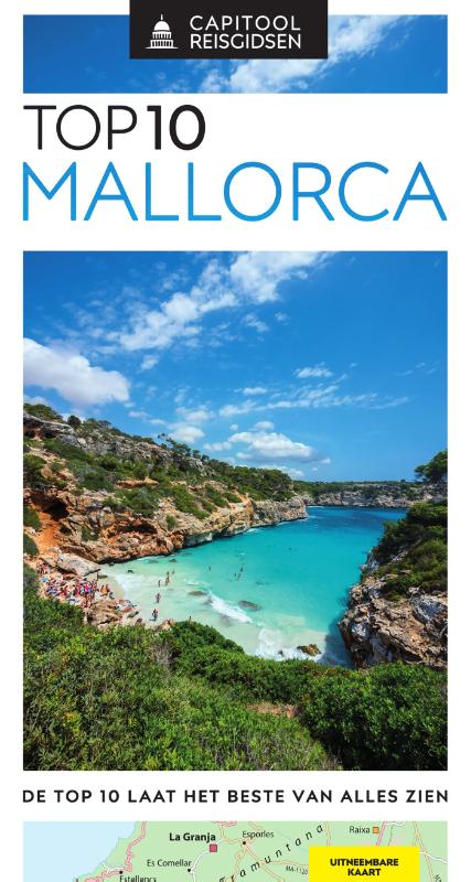
€ 174.95
Wereldbol - Globe 18 Neon Executive ø 30 cm | Met Verlichting | National Geographic

Deze National Geographic Neon Executive wereldbol is een van de favoriete globes voor scholen en hogere onderwijsinstellingen. Dit is te danken aan het neutrale, maar toch sierlijke uiterlijk van het product. Daarnaast is de globe, net als alle andere wereldbollen van National Geographic, zeer eenvoudig af te lezen dankzij het heldere kaartbeeld met een duidelijke aanduiding van politieke grenzen en bergen. De voet is gemaakt van stijlvol essenhout, de bol zal een ware eye-catcher zijn in ieder interieur.

€ 180.00
Prikbord Azië, politiek, 84 x 96 cm | National Geographic

Mooie wandkaart van Azië, staatkundig, met rustig kleurgebruik en helder kaartbeeld, Ondanks het wat kleiner formaat staan er toch heel wat topografische details op vermeld. 


De wandkaarten op prikbord worden geleverd met een aluminium lijst en een eenvoudig te monteren ophangsysteem. Zij zijn geschikt voor allerhande markeringsystemen als vlaggetjes en prikkers.


The map presents Asia at 1: 13,8120,000. Coverage includes the whole of the European part of Russia, extending up to the North Pole. In the south-east the island of New Guinea and the Bismarck Archipelago are shown as an inset. The base map has relief shading to show the continent’s topography, with additional graphics indicating deserts, swamps, glaciers, etc. The map shows the names of the numerous geographic features such as mountain ranges, deserts, peaks etc. Heights are given in feet. 


Country boundaries are in different colours and, where appropriate, disputed boundaries and territotial claims are marked. All place names are in English, except for some cities such as Bukhara, where the original name is shown first (Buxoro) with the English equivalent in brackets. 

€ 220.00
Prikbord Afrika, politiek, 91 x 118 cm | National Geographic

Mooie wandkaart van Afrika, staatkundig, met rustig kleurgebruik en helder kaartbeeld, Ondanks het wat kleiner formaat staan er toch heel wat topografische details op vermeld. 


De wandkaarten op prikbord worden geleverd met een aluminium lijst en een eenvoudig te monteren ophangsysteem. Zij zijn geschikt voor allerhande markeringsystemen als vlaggetjes en prikkers.


The map presents Africa at 1: 9.328.000 and coverage includes the whole of the Mediterranean Basin, extending north to London. Islands in the Atlantic and the Indian Ocean are included on a separate inset. The base map has relief shading to show the continent’s topography, with additional graphics indicating deserts, swamps, salt flats, etc. The map shows the names of the main geographic features such as mountain ranges, deserts, peaks etc. Heights are given in metres, except for Kilimanjaro, shown in both metres and feet. In the Congo basin many of the tributaries are named. 


Country boundaries are shown in contrasting colours. All place names are in English, except for selected cities such as Cairo, Tripoli or Algiers where the original names are shown first (El Quahira, etc) with the English equivalents in brackets. Where appropriate, administrative, legislative and judicial capital cities are indicated (e.g. Dar Es Salam/Dodoma, Johannesburg/Cape Town/Bloemfontein, etc). 

€ 45.95
Wandkaart Afrika, politiek, 91 x 118 cm | National Geographic

Mooie wandkaart van Afrika, staatkundig, met rustig kleurgebruik en helder kaartbeeld, Ondanks het wat kleiner formaat staan er toch heel wat topografische details op vermeld. 


The map presents Africa at 1: 9.328.000 and coverage includes the whole of the Mediterranean Basin, extending north to London. Islands in the Atlantic and the Indian Ocean are included on a separate inset. The base map has relief shading to show the continent’s topography, with additional graphics indicating deserts, swamps, salt flats, etc. The map shows the names of the main geographic features such as mountain ranges, deserts, peaks etc. Heights are given in metres, except for Kilimanjaro, shown in both metres and feet. In the Congo basin many of the tributaries are named. 


Country boundaries are shown in contrasting colours. All place names are in English, except for selected cities such as Cairo, Tripoli or Algiers where the original names are shown first (El Quahira, etc) with the English equivalents in brackets. Where appropriate, administrative, legislative and judicial capital cities are indicated (e.g. Dar Es Salam/Dodoma, Johannesburg/Cape Town/Bloemfontein, etc). 

€ 26.95
Wandkaart 02812 Azië, politiek, 84 x 96 cm | National Geographic

Mooie wandkaart van Azië, staatkundig, met rustig kleurgebruik en helder kaartbeeld, Ondanks het wat kleiner formaat staan er toch heel wat topografische details op vermeld. 

The map presents Asia at 1: 13,8120,000. Coverage includes the whole of the European part of Russia, extending up to the North Pole. In the south-east the island of New Guinea and the Bismarck Archipelago are shown as an inset. The base map has relief shading to show the continent’s topography, with additional graphics indicating deserts, swamps, glaciers, etc. The map shows the names of the numerous geographic features such as mountain ranges, deserts, peaks etc. Heights are given in feet. 


Country boundaries are in different colours and, where appropriate, disputed boundaries and territotial claims are marked. All place names are in English, except for some cities such as Bukhara, where the original name is shown first (Buxoro) with the English equivalent in brackets. 

€ 31.95
Wandkaart Afrika, politiek, 61 x 78 cm | National Geographic

Mooie wandkaart van Afrika, staatkundig, met rustig kleurgebruik en helder kaartbeeld, Ondanks het wat kleiner formaat staan er toch heel wat topografische details op vermeld. 


Kaart is up-to-date, alleen Zuid Sudan wordt niet als een apart land weergegeven.


The map presents Africa at 1: 14,244,000 and coverage includes the whole of the Mediterranean Basin, extending north to London. Islands in the Atlantic and the Indian Ocean are included on a separate inset. The base map has relief shading to show the continent’s topography, with additional graphics indicating deserts, swamps, salt flats, etc. The map shows the names of the main geographic features such as mountain ranges, deserts, peaks etc. Heights are given in metres, except for Kilimanjaro, shown in both metres and feet. In the Congo basin many of the tributaries are named. 


Country boundaries are shown in contrasting colours. All place names are in English, except for selected cities such as Cairo, Tripoli or Algiers where the original names are shown first (El Quahira, etc) with the English equivalents in brackets. Where appropriate, administrative, legislative and judicial capital cities are indicated (e.g. Dar Es Salam/Dodoma, Johannesburg/Cape Town/Bloemfontein, etc). 

€ 1995.00
Magneetbord - Wereldkaart 29M Wereldkaart, politiek, 296 x 193 cm | National Geographic

Een bijzonder grote wereldkaart van National Geographic. Deze kaart is politiek van opbouw: alle landen worden met duidelijke grenzen heel goed zichtbaar. Daarnaast staan er veel plaatsen op en worden ook de dieptes van de verschillende oceanen, golfstromen en heersende windrichtingen weergegeven.


Een prachtige kaart aan de muur, aan de zijkanten afgewerkten met een mooie rand en een heldere maar tegelijk ook vrij zachte, niet overheersende kleurstelling.


Deze kaart wordt gemaakt in drie delen - te groot om in 1 keer te fabriceren met kans op beschadigingen - die vervolgens zeer nauwkeurig aan elkaar worden geplakt. Daarna gaat er een coating overheen om de kaart geplastificeerd te maken. Een heel proces, maar het resultaat is prachtig!


De kaart wordt in deze versie gelijmd op een plaat, voorzien van een mooie aluminium lijst en een ophangsysteem wordt meegeleverd. Daarnaast krijgt u een bakje bijgeleverd dat u er aan kunt bevestigen voor pennen, stiften of magneetjes.


Bij dit magneetbord wordt een set magneetjes (10 stuks) gratis meegeleverd


€ 13.50
Wandelgids 315 Neckarsteig | Conrad Stein Verlag

Der Neckarsteig wurde im Jahr 2012 eröffnet und nach den Kriterien des Deutschen Wanderverbandes als „Qualitätsweg Wanderbares Deutschland“ zertifiziert. Dieser neue Wanderweg folgt den tief eingeschnittenen Windungen des unteren Neckars durch den südlichen Odenwald von der ehemaligen kurpfälzischen Residenz und dem Synonym der Romantik, dem Heidelberger Schloss, bis Bad Wimpfen, der ehemaligen Kaiserpfalz der Staufer. Durch die frühe Bedeutung des Flusses als Verkehrsweg und weil hier die Machtbasis der Staufer Könige und Kaiser war, wurden bereits im Mittelalter entlang des Neckars befestigte Städtchen und Burgen in enger Abfolge errichtet, die das Territorium sicherten.

Noch heute ist der Wanderer beeindruckt von dem Reiz und der Geschlossenheit der mittelalterlichen Bebauung, für die ausschließlich die Werkstoffe vor Ort, der rote Bundsandstein und die Eichenhölzer des Odenwaldes verwendet wurden. Hier findet der Wanderer am Ende einer jeden Etappe über die bewaldeten Höhen und durch die steilen Prallhänge mit Ausblicken auf den Fluss einen angenehmen Aufenthalt. Die Symbiose aus Natur und durch den Menschen gestaltete Umwelt hat eine der schönsten Fluss- und Wanderlandschaften Deutschlands hervor gebracht. Dieser Wanderführer bietet die Grundlage für ein eindrucksvolles Landschaftserleben.

Bad Wimpfen, Eberbach, Heidelberg, Jürgen Plogmann, Mosbach, Neckar, Neckargemünd, Neckarsteig, 

€ 13.95
Stadsplattegrond München | Freytag & Berndt

Stadsplattegrond met register. Helder kaartbeeld waarbij de naamgeving goed leesbaar is weergegeven. Met de toeristische bezienswaardigheden in symbolen weergeven: monumenten, musea, stadions e.a. Daarnaast handige zaken als postkantoren, parkeergarages en stations. Veelal ook met een openbaar vervoer of metro kaart als inzet


Large street plan of Munich within its administrative boundaries, with an enlargement of the city centre, a plan of its airport, a diagram of the U and S-Bahn networks and a map of the outer suburbs all conveniently placed in a separate booklet. 


The main plan covers Munich at 1:22,500, showing the city’s public transport network: tram and bus routes with stops and line numbers, plus U- and S-Bahn stations. Campsites and youth hostels are marked, as well as the usual range of facilities shown on street plans; public buildings, religious establishments, police, etc.


Map legend which includes English is in a separate booklet attached to the map cover. The booklet also contains a very clear enlargement at 1:10,000 of the town centre within the inner ring, indicating one way streets and public transport connection, a diagram of the U- and S-Bahn networks and an overview map of the city with its outer suburbs.


€ 13.95
Stadsplattegrond Klagenfurt | Freytag & Berndt

Stadsplattegrond met register. Helder kaartbeeld waarbij de naamgeving goed leesbaar is weergegeven. Met de toeristische bezienswaardigheden in symbolen weergeven: monumenten, musea, stadions e.a. Daarnaast handige zaken als postkantoren, parkeergarages en stations. Veelal ook met een openbaar vervoer of metro kaart als inzet


Freytag and Berndt, Austria's leading map publishers, produce a series of street plans covering the country's main cities. All the plans are indexed and show public transport system. Plans of cities in the mountainous parts of the country are contoured to indicate the terrain. Most plans have enlargements showing the town centre in greater detail. Some plans include a black and white map of the city overprinted with cycle routes. Map legend includes English.

Abonneer op