De Rother wandelgidsen beschrijven zeer goed de wandelingen in specifieke gebieden. In de gids vindt men kaarten, routebeschrijvingen en de nodige praktische informatie om van de wandelingen/trekkings een geslaagde onderneming te maken.
Zertifiziert als »Qualitätsweg Wanderbares Deutschland«
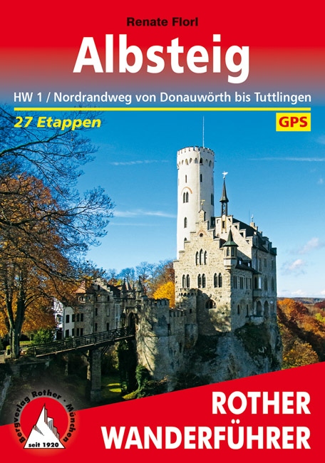
»Wandern auf hohem Niveau«, das bietet der Albsteig in doppelter Hinsicht: Mit herrlichen Panoramablicken zieht er entlang des Albtraufs über die höchsten Gipfel der Schwäbischen Alb, der »Region der 10 Tausender«. Und hohes Qualitätsniveau bestätigen die Auszeichnungen als »Qualitätsweg Wanderbares Deutschland« und »Top Trail of Germany«. Der Rother Wanderführer Albsteig präsentiert diesen Klassiker unter den Fernwanderwegen – auch bekannt als Nordrandweg oder Hauptwanderweg 1 – in 27 eher kurzen, familientauglichen Etappen.
Der Albsteig verläuft auf gut 350 Kilometern auf angenehmen, meist naturbelassenen Wegen von Donauwörth bis nach Tuttlingen, vorbei an spektakulären Burgen und Schlössern wie Burg Teck oder Schloss Lichtenstein. Sehenswert sind auch der romantische Wasserfall von Bad Urach und die Nebelhöhle mit ihren wunderbaren Tropfsteinen. Die einzelnen Etappen lassen sich problemlos zu kürzeren oder längeren Abschnitten kombinieren. So eignet sich der Albsteig auch ideal für ein langes Wochenende oder einen gemütlichen Sonntagsnachmittagsausflug.
Die Autorin Renate Florl liefert alle wichtigen Informationen für eine gelungene Fernwanderung ebenso wie für Tagesausflüge: eine Vielzahl von Unterkünften, Einkehr- und Einkaufsmöglichkeiten, Anbindung an öffentliche Verkehrsmittel und vieles mehr. Jede Etappe enthält eine zuverlässige Wegbeschreibung, ein Wanderkärtchen mit eingezeichnetem Routenverlauf und ein aussagekräftiges Höhenprofil. Zudem stehen GPS-Daten zum Download bereit. Auch für das Lesevergnügen ist gesorgt: Mit viel Liebe zum Detail erzählt die Autorin Wissenswertes zu den großen und kleinen Sehenswürdigkeiten am Wegesrand, und zahlreiche Fotos stimmen schon zuhause auf das Wandern am Albsteig ein.