€ 15.95
Wegenkaart - landkaart New South Wales | Hema Maps

Erg mooie, handige en uitgebreide kaart van New South Wales.

Great for travel planning, Hema's New South Wales state map clearly shows highways, minor and secondary roads, national and state routes and fully-indexed cities, towns and localities. Detailed road distances are also shown.


The flipside of the map features loads of insets covering various bits and pieces throughout New South Wales including a Sydney CBD and throughroads map, a Canberra CBD map, a Sydney region map, a map of the Blue Mountains National Park and a map of the area betwwen Katoomba and Wentworth Falls. There's also a list of information centres giving their address, phone number and website.


The map features:


Camping areas

Rest areas

24 hour fuel locations

Outback fuel stops

Caravan parks

National parks

A full index

Points of interest

A distance grid

€ 8.95
Wegenkaart - landkaart 169 Evia | Orama

Goede wegenkaart van een deel van Griekenland. Waar beschikbaar worden hotels en campings getoond en met symbolen worden allerhande toeristische symbolen aangeduid als historische plaatsen, kloosters, museas etc.  Tweetalig. Op elke kaart staat van de belangrijkste steden een centrumkaart en er is een behoorlijk uitgebreid register (wel kleine letters!) Kleurgebruik is duidelijk, maar een beetje flets, waardoor hoogteverschillen niet echt goed uitkomen. 

Met stadsplattegronden van Chalkida, Karystos, Loutra Edipsou, Eretria, Vasiliko, Amarynthos.

€ 12.95
Wegenkaart - landkaart 585 Western USA - Western Canada | Michelin

Wegenkaart van het westelijke gedeelte van de USA (zuid tot bovenste stukje Mexico, oost tot ongeveer Denver/ Regina) en westelijk Canada (t/m Edmonton in het noorden). Zie uitsnede op de voorkant van de kaart.

Primary & secondary road networks are clearly marked out with indications of the number of lanes, intermediate distances and various possible road obstacles or things you should know including steep hills, height limits, toll barriers, prohibited roads and roads subject to restrictions.


The map also includes small insets with street plans of the regions major towns, showing road names, one way streets and various places of interest (tourist sights, hospitals, parking, railway stations, etc.). Scenic routes on the map are marked out in green and an extensive index of place names is included.


The map also features:


Administrative boundaries

Railways, Airports and Ferry Services

Important sights such as castles, ruins, and churches

Driving Times and Distance Charts

Road Safety Information

A legend in multiple languages, including English

Californie, Canada, Colorado, Etats-Unis, Nord-Ouest américain, Ouest canadien, Sud-Ouest américain

€ 14.95
Wegenkaart - landkaart 9 Niedersachsen - Bremen | Freytag & Berndt

Goede wegenkaart van een deel van Duitsland. Helder kleurgebruik, tweezijdig waardoor meer gedetailleerd met veel toeristische informatie. Met register.


The map highlights picturesque towns and national parks, with a range of symbols marking campsites, youth hostels, museums, spas, various landmarks and places of interest. As with all Freytag & Berndt maps the cartography is clear and detailed with the topography shown by relief shading with plenty of spot heights.


A localities index with postcodes is in a small booklet attached to the cover and the legend is in various languages including English

€ 14.95
Wegenkaart - landkaart Iceland - IJsland | Freytag & Berndt

Gedetailleerde, geplastificeerde landkaart van IJsland met toeristische informatie en stadsplattegronden


Freytag and Berndt tourist map and road map of Iceland - world compact series includes Top tourist information, city maps, text in English and German, waterproof map


Freytag und Berndt Autokarte Island Welt Kompakt 1:550.000 führt Sie in das Land der Vulkane.

Beschreibung der Top-Sehenswürdigkeiten finden Sie auf dieser Übersichtskarte inklusive Stadtpläne, sowie touristische Informationen, Länderinformationen und einen Sprachführer.

Sprachen: Deutsch, Englisch

reiß- und wasserfest


Duidelijk minder gedetailleerd dan de andere Freytag kaart van IJsland, maar groot voordeel is dat deze geplastificeerd is.

€ 14.95
Wegenkaart - landkaart Trentino - Dolomieten - Gardameer - Venetie | Freytag & Berndt

Bijzonder gedetailleerde wegenkaart van Zuid-Tirol & Trentino met alle belangrijke aanduidingen en toeristische symbolen. Met register en aanduiding van campings en afstanden.

De berijdbare wegen zijn goed weergeven, zowel de hoofdwegen als provinciale en lokale wegen; wegnummers worden vermeld. Afstanden tussen plaatsen zijn in kilometers op de kaart ingetekend, daarnaast worden ook op belangrijke plekken benzinepompen gemarkeerd.

In het kaartbeeld wordt door middel van schaduw het reliëf weergegeven en soms enkele punten in het landschap met de daadwerkelijke hoogte. Provinciegrenzen zijn goed terug te vinden, nationale parken en reservaten ook. Met allerhande symbolen worden toeristische bezienswaardigheden weergegeven als monumenten, historisch belangrijke plekken en uitzichtpunten. In bepaalde plaatsen zijn hotels en campings te vinden, luchthavens, treinverbindingen en havens vindt u er ook op!

€ 11.75
Wegenkaart - landkaart 6 Dienvidlatgale - Zuid Latgale - Letland | Jana Seta


Dienvidlatgale 1:200.000

Toeristische kaart Zuid Latgale, Zuid oost Letland


Met detailkaarten (1:20.000) van de plaatsen: Daugavpils, Jekabpils, Kraslavas, Ludzas, Preilu en Rezekne


Dit is een kaart uit de zes delige kaartenserie van toeristische kaarten van Letland. De kaart bevat: verharde en onverharde wegen, bezinestations, spoorwegen en stations, accomodatie, campings, dorpen en steden, grensovergangen, nationale parken en beschermde gebieden. De kaart bevat ook stadsplattegronden van alle grotere plaatsen op het kaartblad en beschrijvingen van toeristische attracties in de regio.


Detailed network of roads, populated areas and farmsteads, forests, swamps and, of course, various tourism and service objects: castles, manors, museums, nature specimens, hills and castle mounds, sports complexes, tourism information centres, filling stations and gas filling stations, restaurants and cafes, hotels, motels, campings and other accommodation places.

€ 14.95
Wegenkaart - landkaart Namibië - Namibia | MapStudio

Duidelijke overzichtskaart van Namibië, met kleine stadskaart van het centrum van Windhoek.

Namibia Adventure Road Map is an easy-to-read full colour map of Namibia with region boundaries, distance in kilometers, international border posts, detailed place name index, major and minor town names, settlements, GPS co-ordinates, places of interest, major airports, accommodation, with colour coded topographic terrain detail and street plan of Windhoek.


€ 14.95
Wegenkaart - landkaart Alaska | Freytag & Berndt

Gedetailleerde, tweezijdige landkaart van Alaska, prima geschikt voor planning en rondtrekken . De berijdbare wegen zijn goed weergeven, zowel de hoofdwegen als provinciale en lokale wegen; wegnummers worden vermeld. 

In het kaartbeeld wordt door middel van schaduw het reliëf weergegeven en soms enkele punten in het landschap met de daadwerkelijke hoogte. Provinciegrenzen zijn goed terug te vinden, nationale parken en reservaten ook. Met allerhande symbolen worden toeristische bezienswaardigheden weergegeven als monumenten, historisch belangrijke plekken en uitzichtpunten. In bepaalde plaatsen zijn hotels en campings te vinden, luchthavens, treinverbindingen en havens vindt u er ook op!

€ 13.95
Wegenkaart - landkaart Alaska's Inside Passage | ITMB

Een degelijke kaart met aanduidingen van o.a. nationale parken, vliegveld, benzinepomp, dirt-roads en kleine plattegronden van Anchorage, Seattle, Vancouver en Victoria. Als overzichtskaart goed te gebruiken.


 We recently released our USA Pacific Coast Map, covering the segment between San Diego and Vancouver. This map completes the mapping of the Pacific Ocean coastline by mapping the routes followed by cruise ships and Alaska Ferries heading north from Seattle and Vancouver to Alaska. This is a double-sided map, with Vancouver Island and the coastline as far north as Prince Rupert on one side (with inset maps of Seattle, Victoria, and Vancouver)on side 1, and the coastline north to Glacier Bay and an onward inset map to Anchorage (including an inset map of the city) on the second side. As the actual routes followed by the numerous cruise lines vary, we can't show their actual sailing routes, but they generally follow the coastline within viewing distance of either the mainland or coastal islands, or both. We have included the normal ferry routes followed by both BC Ferries and Alaska Ferries in their network of watery trails joining coastal communities, and the large cruise ships follow much the same routes.


Legend Includes:

Roads by classification, International Boundaries, Provincial Boundaries, Railways, Mountain Peaks, Population Areas, Province Capitals, Major Cities, Cities, Provincial Parks, Lakes, Rivers, National Parks, Snowfields, Glaciers, Border Crossing, Airports, Airfields, Points of Interest, Viewpoints, Hotels and Accomodations, Day-Use Areas, Camping, Boat Launches, Fishing, Museums, Gas Stations, Universities, Skiing, Golf Courses, Hospitals and Medical Services, Mines, Passes, Campground RV, Hiking, Kayaking and much more

€ 15.95
Wegenkaart - landkaart Botswana | Infomap

Goede betrouwbare kaart van Botswana. Met GPS coordinaten.

Easy to read in a vehicle

Practical, user-friendly scale

Extensive countrywide accommodation listing and contact details

Experienced-based tips and route comments

Includes many off-road tracks

GPS co-ordinates of intersections

Border post information

Many points of interest

Distances, fuel points, airports

Booking details for national parks

Roads and tracks in the national park and reserves

Inset of Tuli Block

A classic. Our Botswana map, now in its 14th edition, is one of our top sellers. From more frequented destinations such as the country’s famous game parks to other lesser known ones like Tsodilo Hills – Botswana’s World Heritage site with over 4000 rock paintings – this map is a one-stop resource for both self-drive travellers and fly-in tourists alike. Use it to navigate your way from Gaborone to Maun, from Kasane down the Hunters Road to Khubu Island, from Twee Rivieren to the Kalahari, or simply use it as a visual resource for your upcoming tour.


Botswana is one of Africa’s most politically and economically stable countries with a well-established tourist industry. It is renowned as an ideal safari destination. The Batswana (citizens of Botswana) are famously friendly and the country is one of the safest on the continent.  With a relatively small population this largely arid country had an economy that was traditionally based on cattle farming – however the discovery of major diamond deposits in the last 30 years has changed this. Diamond production is the now the second highest in the world.


An incredible 38% of the land is set aside for the preservation of wildlife through national parks, reserves or private wildlife areas. Enormous areas such as the Central Kalahari Game Reserve, Chobe, Makgadigadi Pans or Moremi / Okavango are veritable ‘Edens’, supporting healthy populations of game, and offering an unrivalled safari experience. With so much emphasis on eco-tourism it is no surprise that there is a plethora of options in terms of travel preferences or accommodation requirements. Serious, self-sufficient campers and other experienced outdoor enthusiasts can seek solitude in the endless expanse of the Western Woodlands, the Kgalagadi, Kalahari, Makgadigadi pans and other areas. Self-drive tourists can spend their days watching wildlife and their nights in comfort at a host of lodges or self-catering accommodation spread throughout the country. Then of course there are luxury camps dotted throughout the wilderness areas – with exclusive safaris in the often private consessions where only a few visitors may enter. Many of these types of accommodation are listed on our Botswana map.


This map is packed with useful and up to date travel information such as GPS points at intersections, points of interest, accommodation listing, fuel, border posts, national parks routes and camps, national park booking information, emergency contacts, national road networks and 4×4 tracks. This is a vital resource to any traveler to the country!

€ 13.95
Wegenkaart - landkaart Afghanistan | ITMB

Een degelijke kaart met aanduidingen van o.a. nationale parken, vliegveld, benzinepomp, dirt-roads en kleine plattegrond van hoofdstad. Als overzichtskaart goed te gebruiken.

Legend Includes:
Roads by classification, silk road, airports, towns, villages, ruins, national parks, lakes, swamps, points of interest and other information

It is a bit difficult to credit Afghanistan having touristic potential at the moment, but it is an extremely important country right now, and that justifies a very good map of the country. This is our third edition of this country and each one keeps getting better. We can’t justify sending a researcher into a combat zone to gather data, but we are thankful to those aid workers and soldiers who have added to our information base and helped make this map more useful. In this edition, we are showing some new roads, reflecting the reality that the country is succeeding in improving its infrastructure in spite of a very tense political situation. We have also placed more focus on the borderlands with Pakistan as that country has been immersed in the Afghan conflict. This edition is dedicated to the Canadian forces, both military, police, and civilian, who are trying so hard to bring peace and stability to southern Afghanistan and who have suffered more than 100 casualties to date. This is not to minimize the enormous contributions being made by many tens of thousands of men and women of other nations, or their equally heavy losses, but as a Canadian, I feel closer to our own. The map also shows a good inset map of Kabul and a recent cover picture taken by one of our helpers

€ 11.95
Wegenkaart - landkaart 730 Oostenrijk 2024 | Michelin

Zoals je van Michelin mag verwachten is deze kaart zeer overzichtelijk en heeft een duidelijk helder kaartbeeld. De kaart geeft uitgebreid toeristische informatie weer. Met register, afstanden en reistijden.

Wegen worden naar verschillende klasse ingedeeld en - mooi van Michelin - de interessante mooie routes worden gemarkeerd met een groene streep. 


Hindernissen voor automobilisten met caravans zijn gemarkeerd: steile hellingen, bergpassen of een anderzins moeilijke route. Bezienswaardigheden als een kasteel, religieus gebouw, ruine of grot is door een symbool goed te vinden.

The Michelin National road map of Austria at 1:400,000 scale is ideal for route planning and touring. The map gives comprehensive coverage of national road networks showing all major motorways, dual carriageways, national & regional main roads and some single-lane roads. Also shows unsurfaced roads and tracks and major footpaths. The map is divided by grid showing latitude and longitude.


Distances between major locations are marked along roads, with total distance and several intermediate distances shown. A quick-reference chart of distances & driving times between major locations is also included. The map also includes a grid-referenced index of principal place names.


Clear, easy-to read cartography shows roads in reds, yellows and white with black outlines. Major topography is indicated with relief shading. Woodland & forest is marked with green shading. Built-up urban areas are clearly marked in yellow. Airports, ferries (with listed weight limits), railways are also marked. National and administrative divisions are marked. Not only are sites of interest marked, they are marked in some cases to correspond with their respective parts as featured in Michelin’s Green Guide to Austria.


Also includes a quick reference panel giving national driving regulations, including speed limits, equipment requirements (e.g. bulb kits, warning triangles) and seatbelt rules, for all countries principally shown.


City plans & regional enlargements:

- Vienna at scale 1:100,000

- Salzburg at scale 1:70,000


Autriche, Bregenz, Graz, Innsbruck, Linz, Salzbourg, Vienne

€ 11.50
Wegenkaart - landkaart Seychelles - Seychellen | Borch

Mooie geplasticieerde kaart vande Seychellen. Deze kaart biedt een goed overzicht van het land met detailkaarten.


Our soft-laminated folded map of Seychelles shows: Bird Island, Denis, Arid, Fregate 1:25 000, Mahe, Silhouette, Praislin, La Digue, Marianne, Desroches, North 1:50 000, Inner Islands 1:750 000, Seychelles 1:4 500 000, Victoria 1:13 000, Vallée de Mai 1:13 000 and Aldabra, Amirantes, Farquhar 1:2 500 000, Seychelles time zones. Borch Maps are easy to fold, durable and water-repellent with a wipeable surface. Borch Maps show hotels, museums, monuments, markets, public transport, top sights and points of interest, useful statistics, conversion charts for temperatures, weights and measurements, climate charts showing temperatures, sunshine hours, precipitation and humidity, overview maps, time zones, and much more...


The Republic of Seychelles is an archipelago of 115 granitic and coralline islands in the Indian Ocean, located east of Africa and northeast of Madagascar. Seychellois Creole, French, and English, are the main languages spoken by the local "Seychellois", who are predominantly Christian and mainly of French, African and Indian descent. The Seychelles are best known as the ultimate luxury island retreat in the Indian Ocean; Mahe, Praslin, La Digue and Silhouette being the best-known islands, with prestigious accommodation and unparalleled natural beauty - a waterbound paradise in all shades of blue and green, with tranquil beaches, untouched forests, pristine ecosystems, vibrant flora and fauna and countless opportunities for diving, sailing, fishing, trekking and island-hopping. Wedding, honeymoon and spa vacations are especially popular for those wishing to get away from it all. This is a luxurious, world-class destination you are guaranteed never to forget. The rainy season is in January and February, and the archipelago is located safely outside the cyclone belt.


€ 14.50
Wegenkaart - landkaart Frankrijk | Hallwag

Prima kaart van heel Frankrijk op 1 kant bedrukt met plaatsnamen index. Met distoguide: een afstanden tabel op schuifkaart die de afstanden geeft tussen de belangrijkste plaatsen.

STRASSENKARTEN MIT DISTOGUIDE Aktuelle Information, übersichtliche Darstellung, einfache Handhabung: das Markenzeichen der Hallwag-Strassenkarten. Das internationale Programm mit neuen Ideen für besseres Reisen bietet Ihnen überzeugende Vorteile. Distoguide - der eingebaute «Kilometerzähler» - auf der Aussenseite des Kartendeckels. Für den einfachen und schnellen Zugriff. Sehr praktisch für Planung und Reise! Mit Leichtigkeit lassen sich auf dem im Kartendeckel integrierten Distanzenschieber über 2000 Entfernungen ablesen. Massstab: 1 : 1 000 000

€ 13.95
Wegenkaart - landkaart Ghana | ITMB

Een degelijke kaart met aanduidingen van o.a. nationale parken, vliegveld, benzinepomp, dirt-roads en kleine plattegrond van hoofdstad. Als overzichtskaart goed te gebruiken.

Folded road and travel map in color. Scale 1:500,000. Distinguishes roads ranging from motorways to other roads. Legend includes tracks, railroads, ferry routes, international airports, national airports, aerodromes/small aircrafts, gasoline/petrol stations, bus stations, hospitals/medical facilities, castles/forts, points of interest, ruins or archaeological sites, campsites and huts, museums, lodges, churches, mosques. Includes inset map of Cape Coast, Accra and Kumasi. Extensive index.

€ 13.95
Wegenkaart - landkaart Great Britain - Engeland - Schotland | ITMB


Een degelijke kaart met aanduidingen van o.a. nationale parken, vliegveld, benzinepomp, dirt-roads en kleine plattegrond van hoofdstad. Als overzichtskaart goed te gebruiken.


This is the third set of artwork for Great Britain that we have published and the first that is completely our own artwork (the previous versions were joint ventures). In mapping, as in life, one has to differentiate between the political entity known as the United Kingdom and the geo-political reality of Greater Britain, which includes the Channel Islands, the Isle of Man, and various assorted entities that are loosely attached to the UK by history. We have tried, in this edition, to combine a detailed road map with a touristic sites map. Given that Britain is both densely covered by thousands of narrow laneway passing themselves off as sub-B level roads and by having the greatest treasure trove in the world of castles, manor houses, gardens, museums, and interesting places worth visiting, and the task of portraying all this information becomes formidable. To keep the map from becoming too cluttered, we had to compromise, so if you don't find the little laneway leading to your favourite pub in Devon, sorry. We've done our best to portray Britain as positively as possible, so if you're hankering to visit Foula Island, it's on the map!

€ 13.95
Wegenkaart - landkaart Andalusië - Andalusië | Reise Know-How Verlag

Tweetalige kaart (Engels en Duits). Door ingetekende lengte- en breedtegraden is het gebruik van GPS mogelijk. Met hoogtelijnen en uitgebreid wegennetwerk: daarnaast worden ook de afstanden tussen belangrijke plaatsen duidelijk leesbaar weergegeven. Het kleurgebruik is zodanig dat je een goede indruk krijgt van hoogteverschillen en soorten landschap. Natuurlijk staan de toeristische bezienswaardigheden duidelijk vermeld.


Gedrukt op water- en scheurvast papier! Polyart is een synthetisch product vrij van giftige stoffen dus duurzaam. Het papier gaat echt lang mee.


Topography is indicated by altitude colouring with numerous spot heights and names of mountain ranges and passes. Salt lakes, swamps, seasonal rivers and glacier are also shown. Detailed presentation of the road network includes minor roads and tracks and railways are also shown.


Internal administrative units are presented with their boundaries and names. National parks and other protected areas are highlighted. A wide range of symbols mark various places of interest. Map legends include English and all the maps have an index of localities.

€ 9.95
Wegenkaart - landkaart Fleximap Crete - Kreta | Insight Guides

Geplastificeerde kaart van Kreta, met register. Voor de 'gewone' toerist een handige kaart, geen groot formaat, overzichtelijk met alle belangrijke plaatsen goed weergegeven.


New edition of the bestselling map to Crete. Clear, detailed mapping in 1 : 225,000 scale with symbols highlighting key points of interest. Includes detailed maps of Crete East, Crete West and street plan for Heraklion. Fully indexed and in an easy-to-fold format with write-ups for 25 Top Attractions cross-referenced to the maps to aid route-planning. Also includes facts for the visitor and tips for getting around. Laminated, tear-proof finish ensures durability in high use.

€ 14.95
Wegenkaart - landkaart Morocco - Marokko | Marco Polo

Duidelijke wegenkaart van Marco Polo: alle wegen, zowel de verharde als belangrijke onverharde wegen zijn weergegeven.  Mooie toeristisch interessante wegen die de moeite waard zijn, zijn groen gearceerd. Veel toeristische informatie is toegevoegd zoals de nationale parken, campings, kastelen en vliegvelden. Afstanden tussen belangrijke steden en benzinestations staan ook op de kaart. Een plaatsnamenregister ontbreekt niet.


---


This Marco Polo map of Morocco features really easy to read cartography. Topography is highlighted with relief shading and loads of spot heights and the road network is clearly shown with roads ranging from motorways all the way through to minor secondary roads. The map also clearly indicates airports, places of interest, scenic/tourist routes, view points etc.


The map includes a booklet attached to the cover that contains some useful information and a very extensive index that covers locations, places of interest and geographical features. Also included are a distance/driving time chart and a fold out flap on the cover with an overview map of the region covered.


The legend is in a multitude of languages including English.


---


Entdecken Sie mit dieser MARCO POLO Karte das Land der bunten Märkte und Paläste . . . Die Karten bestechen durch eine leicht lesbare, neue Kartografie, in der durchgängig landschaftlich schöne Strecken und Orte markiert sind. Schon in der im Kartendeckel befindlichen, ausklappbaren Übersichtskarte sind die schönsten Orte mit "Marco-Polo-Highlight- Sternen" gekennzeichnet und mit gelben oder grünen Markierungen unterlegt, um unterwegs auch wirklich nichts zu verpassen. Wo alle Orte auf der Karte zu finden sind, ist im Registerheft nachzuschlagen.


Sprachen: Deutsch, Englisch, Französisch


Hauptkarte 1: 800 000 mit mehrsprachiger Legende (GB, D, F, NL, I, E, CZ, PL) Übersichtskarte zum Ausklappen, Entfernungstabelle, Zoomsystem/ Index: Marco Polo Highlights, 7 Citypläne: - Ceuta - Fès - Marrakech - Melilla - Meknès - Rabat - Tanger/ Wichtige Verkehrsinformationen/ Reiseinformationen/ Nationalparks, Naturparke und Welterbestätten der UNESCO Übersichtskarte der Bezirke/ Ortsregister mit Region und Suchfeldangabe, ausgewählten Sehenswürdigkeiten, Landschafts- und Gewässernamen.


€ 14.95
Wegenkaart - landkaart Belgium and Luxembourg - België en Luxemburg | Marco Polo

Duidelijke wegenkaart van Marco Polo: alle wegen, zowel de verharde als belangrijke onverharde wegen zijn weergegeven.  Mooie toeristisch interessante wegen die de moeite waard zijn, zijn groen gearceerd. Veel toeristische informatie is toegevoegd zoals de nationale parken, campings, kastelen en vliegvelden. Afstanden tussen belangrijke steden en benzinestations staan ook op de kaart. Een plaatsnamenregister ontbreekt niet.


Es ist gut zu wissen, wo sich im Urlaubsgebiet die bedeutenden kulturellen und landschaftlichen Sehenswürdigkeiten befinden. Das präzise und klar lesbare Kartenbild der MARCO POLO Karte führt Sie nicht nur zu diesen wirklich interessanten Stellen, sondern zeigt Ihnen außerdem noch viele andere wissenswerte Details. Dank des großen Maßstabs 1:250 000 können Sie sich gut in der fremden Landschaft orientieren und finden auch auf interessanten, abgelegenen Straßen sicher zum Ziel.


Mit den MARCO POLO Karten können Sie sich auch im Ausland so sicher orientieren wie in der Heimat! Maßstäbe und Karteninhalte sind optimal an das jeweilige Land angepasst.


€ 13.95
Wegenkaart - landkaart Israel - Palestine | Reise Know-How Verlag

Tweetalige kaart (Engels en Duits) van Israël en Palestina. Door ingetekende lengte- en breedtegraden is het gebruik van GPS mogelijk. Met hoogtelijnen en uitgebreid wegennetwerk: daarnaast worden ook de afstanden tussen belangrijke plaatsen duidelijk leesbaar weergegeven. Het kleurgebruik is zodanig dat je een goede indruk krijgt van hoogteverschillen en soorten landschap. Natuurlijk staan de toeristische bezienswaardigheden duidelijk vermeld.


Gedrukt op water- en scheurvast papier! Polyart is een synthetisch product vrij van giftige stoffen dus duurzaam. Het papier gaat echt lang mee.


Topography is indicated by altitude colouring with numerous spot heights and names of mountain ranges and passes. Salt lakes, swamps, seasonal rivers and glacier are also shown. Detailed presentation of the road network includes minor roads and tracks and railways are also shown.


Internal administrative units are presented with their boundaries and names. National parks and other protected areas are highlighted. A wide range of symbols mark various places of interest. Map legends include English and all the maps have an index of localities.

€ 15.95
Wegenkaart - landkaart Macedonië - Macedonia | Gizi Map

Goede wegenkaart van Macedonië met spoorlijnen en veel topografische details en plaatsnamen. Met index en kleine stadskaart van Skopje.

Geindexeerde wegenkaart van Macedonië op 1: 250.000 van Gizi Map met een stratenplan van centraal Skopje. De kaart biedt een levendige presentatie van de bergachtige topografie van het land door middel van reliëfschaduw, hoogtekleuren, piekhoogten en veel namen van bergketens, plus markering van de nationale parken. Namen van veel steden worden ook weergegeven in het Cyrillische alfabet.


Wegennet omvat lokale wegen en sporen, toont rijafstanden op hoofd- en veel secundaire routes en geeft grensovergangen van de buurlanden aan. Spoorlijnen en lokale luchthavens zijn inbegrepen. Symbolen geven locaties aan met toeristische accommodatie, campings en andere interessante plaatsen. Breedtegraad- en lengtegraadlijnen worden getekend met intervallen van 15 '. De index staat naast de kaart. Legende van kaarten bevat Engels. Er is ook een stratenplan van het centrum van Skopje voorzien van plaatsen met interesse.


€ 13.95
Wegenkaart - landkaart Afrika noordwest - Africa northwest | ITMB

Een degelijke kaart met aanduidingen van o.a. nationale parken, vliegveld, benzinepomp, dirt-roads en kleine plattegrond van hoofdstad. Als overzichtskaart goed te gebruiken.

This is the detailed map of Africa emanating from our continental data base and, at an scale better than Michelin's famous regional map, we feel that this version is a winner. First, it is printed double-sided with the western coastal segment on one side and the eastern half on the other. Second, we have been able to improve the accuracy of the road information enormously at the better scale, and third we are making progress in developing a new series of travel maps for Africa by publishing the first of what we hope will become a new regional map covering Africa from top to bottom, or from Cape to Cairo, as Uncle Cecil used to say. The coverage of this map is from Morocco in the west to the Libyan/Egyptian border and from Senegal and Liberia in the southwest to the Chad/Sudan border in the southeast. This is also the first time that we have included any mapping for Guinea, Liberia, or the Ivory Coast on any of our maps, albeit not at a scale that we feel is appropriate yet! 


Legend Includes:

Road by classification, motorways, main roads, secondary road, railway, internationl airports, castles, ruins, waterfall, border crossing, Point of Interests and much more...

€ 14.95
Wegenkaart - landkaart Yemen - Jemen | Freytag & Berndt

Uitstekende kaart van Jemen. Met index, Nationale parken en afstanden in kilometers. Goed kaartbeeld, register. Wel een vrij grote lap van een kaart, maar prima in detail en geen probleem in de auto / camper.

De berijdbare wegen zijn goed weergeven, zowel de hoofdwegen als provinciale en lokale wegen; wegnummers worden vermeld. Afstanden tussen plaatsen zijn in kilometers op de kaart ingetekend, daarnaast worden ook op belangrijke plekken benzinepompen gemarkeerd.

In het kaartbeeld wordt door middel van schaduw het reliëf weergegeven en soms enkele punten in het landschap met de daadwerkelijke hoogte. Provinciegrenzen zijn goed terug te vinden, nationale parken en reservaten ook. Met allerhande symbolen worden toeristische bezienswaardigheden weergegeven als monumenten, historisch belangrijke plekken en uitzichtpunten. In bepaalde plaatsen zijn hotels en campings te vinden, luchthavens, treinverbindingen en havens vindt u er ook op!

€ 12.50
Wegenkaart - landkaart 27 Marco Polo Freizeitkarte Frankfurt - Taunus | MairDumont

Regionale kaart met veel praktische informatie als campings, bezienswaardigheden, fietsroutes etc.  Een handige kaart als je vanuit een bepaalde standplaats de omgeving wilt verkennen. 

Zoals op het overzicht te zien is, blijkt niet heel Duitsland gedekt door deze serie. Zo zijn de landsgrenzen met Nederland niet in kaart gebracht door Marco Polo. Kijk dus goed op het overzicht hoe deze kaart uitgesneden is.


Im praktischen Set: Freizeitkarte und Freizeitführer für die schönsten Ausflüge für Freizeit und Familie.


* 66 spannende Freizeittipps.

* 8 bis 10 abwechslungsreiche Radtouren

* Viele Symbole zeigen die Sehenswürdigkeiten

* Ausführliche Beschreibung der Freizeittipps.

* Detailierte Beschreibung der Radtouren


Freizeitkarte:

66 Tipps sind in der Karte farblich nach Themen gekennzeichnet, am Kartenrand als Kurz-Orientierung durch Bild und Text erklärt und im Extra Guide ausführlich beschrieben. Mit Tipps zu Erlebnis, Natur und Kultur und 20-30 in der Karte eingezeichneten Wanderparkplätzen. Zusätzliche Hinweise am Kartenrand. Empfehlungen für Familien mit Kindern und Empfehlungen bei Schlechtwetter .

Der Extra Guide:

Im Extra Guide sind die 66 Tipps aus der Karte beschrieben. Zusätzlich enthalten und in der Karte eingezeichnet sind ca. 10 Fahrradtouren und ca. 20-30 Biergärten und Ausflugslokale.

€ 14.95
Wegenkaart - landkaart Canada | Freytag & Berndt

Gedetailleerde, tweezijdige landkaart van Canada, prima geschikt voor planning en rondtrekken . De berijdbare wegen zijn goed weergeven, zowel de hoofdwegen als provinciale en lokale wegen; wegnummers worden vermeld. Afstanden tussen plaatsen zijn in kilometers op de kaart ingetekend, daarnaast worden ook op belangrijke plekken benzinepompen gemarkeerd.

In het kaartbeeld wordt door middel van schaduw het reliëf weergegeven en soms enkele punten in het landschap met de daadwerkelijke hoogte. Provinciegrenzen zijn goed terug te vinden, nationale parken en reservaten ook. Met allerhande symbolen worden toeristische bezienswaardigheden weergegeven als monumenten, historisch belangrijke plekken en uitzichtpunten. In bepaalde plaatsen zijn hotels en campings te vinden, luchthavens, treinverbindingen en havens vindt u er ook op!

€ 14.95
Wegenkaart - landkaart Centraal Azië | Freytag & Berndt

Gedetailleerde, eenzijdige landkaart van Centraal Azië, prima geschikt voor planning en rondtrekken . De berijdbare wegen zijn goed weergeven, zowel de hoofdwegen als provinciale en lokale wegen; wegnummers worden vermeld. Afstanden tussen plaatsen zijn in kilometers op de kaart ingetekend, daarnaast worden ook op belangrijke plekken benzinepompen gemarkeerd.

In het kaartbeeld wordt door middel van schaduw het reliëf weergegeven en soms enkele punten in het landschap met de daadwerkelijke hoogte. Provinciegrenzen zijn goed terug te vinden, nationale parken en reservaten ook. Met allerhande symbolen worden toeristische bezienswaardigheden weergegeven als monumenten, historisch belangrijke plekken en uitzichtpunten. In bepaalde plaatsen zijn hotels en campings te vinden, luchthavens, treinverbindingen en havens vindt u er ook op!

€ 14.95
Wegenkaart - landkaart Schotland en Noord Engeland | Freytag & Berndt

Goede tweezijdige wegenkaart van het Noord Engeland en Schotland. Met register en enkele stadsplattegronden.

De berijdbare wegen zijn goed weergeven, zowel de hoofdwegen als provinciale en lokale wegen; wegnummers worden vermeld. Afstanden tussen plaatsen zijn in kilometers op de kaart ingetekend, daarnaast worden ook op belangrijke plekken benzinepompen gemarkeerd.


In het kaartbeeld wordt door middel van schaduw het reliëf weergegeven en soms enkele punten in het landschap met de daadwerkelijke hoogte. Provinciegrenzen zijn goed terug te vinden, nationale parken en reservaten ook. Met allerhande symbolen worden toeristische bezienswaardigheden weergegeven als monumenten, historisch belangrijke plekken en uitzichtpunten. In bepaalde plaatsen zijn hotels en campings te vinden, luchthavens, treinverbindingen en havens vindt u er ook op!


Neben der übersichtlichen Gestaltung bietet die Straßenkarte "Schottland - Nordengland 1:400.000" zahlreiche Zusatzinformationen wie z.B. Sehenswürdigkeiten, Campingplätze und einen Innenstadtplan von Edinburgh.

Mit dem umfangreichen Ortsregister gelingt eine rasche Orientierung.

Schottland - Nordengland 1:400.000


Maßstab 1:400.000

Entfernungen in km

Aussichtspunkte

Ortsregister

Touristische Informationen

Cityplan Edinburgh

Doppelseitig


€ 11.50
Wegenkaart - landkaart Brazilië - Brazil | Borch

Mooie geplasticieerde kaart van het Brazilië. Deze kaart biedt een goed overzicht van het land met detailkaarten.

Our soft-laminated map of Brazil in the 5th edition includes: Brazil 1:4 000 000, Fernando de Noronha Island 1:4 000 000, Brazil Amazon 1:8 000 000, Brasíiia 1:60 000, Manaus 1:15 000, Rio de Janeiro Center 1:15 000, Rio de Janeiro 1:175 000, Sao Paulo 1:20 000, Fortaleza 1:15 000, Natal 1:22 000, Recife 1:15 000, Salvador 1:14 000, Curitiba, Florianópolis, Porto Alegre each 1: 15 000, Brazil administrative & time zones; interesting statistics: conversion chart for temperatures, weights and measures; climate chart with temperatures, sunshine hours, precipitation and humidity; hotels, museums, markets and much more.


The Federative Republic of Brazil is the fifth largest country in the world, the largest and most populous country and largest economy in South America and the seventh largest economy in the world. Bordered by the Atlantic Ocean to the east, the remaining border is formed by all the other South American countries except for Chile and Ecuador. Because Brazil was colonized by the Portuguese in 1500 it is the only South American country in which the official languag is Portoguese. Although it has a very large population (193 million) with urban centres concentrated primarily along the coast, there are vast uninhabited areas in the interior of the country. Both the Equator and the Tropic of Capricorn traverse Brazil. Due to the climate ranging from tropical to sub-tropical, the flora and fauna here are lush, colourful and plentiful. Natural resources are found in abundance. Besides the magnificent natural attractions the country has to offer "The Carnival de Brazil" and the endless beaches of Rio de Janeiro attract tourists the year round.

€ 14.95
Wegenkaart - landkaart Australia - Australië | Freytag & Berndt

Gedetailleerde landkaart van Australië, prima geschikt voor planning en rondtrekken. De berijdbare wegen zijn goed weergeven, zowel de hoofdwegen als provinciale en lokale wegen; wegnummers worden vermeld. Afstanden tussen plaatsen zijn in kilometers op de kaart ingetekend, daarnaast worden ook op belangrijke plekken benzinepompen gemarkeerd.

In het kaartbeeld wordt door middel van schaduw het reliëf weergegeven en soms enkele punten in het landschap met de daadwerkelijke hoogte. Provinciegrenzen zijn goed terug te vinden, nationale parken en reservaten ook. Met allerhande symbolen worden toeristische bezienswaardigheden weergegeven als monumenten, historisch belangrijke plekken en uitzichtpunten. In bepaalde plaatsen zijn hotels en campings te vinden, luchthavens, treinverbindingen en havens vindt u er ook op!


Explore the Commonwealth nation of Australia with this Freytag & Berndt road map. It will allow you to plan your itinerary, and travel independently. The topography is clear and well marked with colour shading, with plenty of spot heights. The map covers the whole of the continent of Australia. 


Freytag & Berndt maps make use of a marking and icon system which makes it easy for you to find what you need. Tourist information shown includes:


Roads, railways, tracks and ferry routes

Prohibited areas and native settlements

Natural features such as rivers and reefs

Places to visit such as zoos, caves, castles and World Heritage sites


Distances between points are shown in kilometres. The legend is in several languages, including English.

€ 11.95
Wegenkaart - landkaart 717 Luxemburg 2024 | Michelin

Zoals je van Michelin mag verwachten is deze kaart zeer overzichtelijk en heeft een duidelijk helder kaartbeeld. De kaart geeft uitgebreid toeristische informatie weer. Met stadsplattegrond van de hoofdstad.

The Michelin National road map of the Grand Duchy of Luxembourg at 1:150,000 scale is ideal for trip & route planning and touring. The map gives comprehensive coverage of national road networks showing all major motorways, dual carriageways, national & regional main roads and some single-lane roads. Also shows unsurfaced roads, tracks, and major footpaths. The map is divided by grid showing latitude and longitude.

Distances between major locations are marked along roads, with total distance and several intermediate distances shown. A quick-reference chart of distances & driving times between major locations is also included. The map also includes a grid-referenced index of principal place names.


Clear, easy-to read cartography shows roads in reds, yellows and white with black outlines. Woodland & forest is marked with green shading. Built-up urban areas are clearly marked in yellow. Airports, ferries (seasonal services clearly marked as such), railways are also marked. National and administrative divisions are marked; areas of interest, such as caves, viewpoints, monuments, are all clearly marked.


Also includes a quick reference panel giving national driving regulations, including speed limits, equipment requirements (e.g. bulb kits, warning triangles) and seatbelt rules.


Town plans & regional enlargements:


- Luxembourg at 1:20,000 scale


Luxembourg

€ 11.50
Wegenkaart - landkaart Baikalsee - Baikalmeer | Reise Know-How Verlag

Tweetalige kaart (Engels en Duits). Door ingetekende lengte- en breedtegraden is het gebruik van GPS mogelijk. Met hoogtelijnen en uitgebreid wegennetwerk: daarnaast worden ook de afstanden tussen belangrijke plaatsen duidelijk leesbaar weergegeven. Het kleurgebruik is zodanig dat je een goede indruk krijgt van hoogteverschillen en soorten landschap. Natuurlijk staan de toeristische bezienswaardigheden duidelijk vermeld. Alle plaatsnamen ook in Cyrillisch schrift.


Gedrukt op water- en scheurvast papier! Polyart is een synthetisch product vrij van giftige stoffen dus duurzaam. Het papier gaat echt lang mee.


Topography is indicated by altitude colouring with numerous spot heights and names of mountain ranges and passes. Salt lakes, swamps, seasonal rivers and glacier are also shown. Detailed presentation of the road network includes minor roads and tracks and railways are also shown.


Internal administrative units are presented with their boundaries and names. National parks and other protected areas are highlighted. A wide range of symbols mark various places of interest. Map legends include English and all the maps have an index of localities.


€ 14.95
Wegenkaart - landkaart 2 Dalmatische Kust Sibenik - Split - Vis | Freytag & Berndt

Uitstekende wegenkaart van een klein gebied tussen Split en Murter aan de Dalmatische kust van Kroatie. Zeer gedetailleerde kaart met hoogtelijnen en andere topografische details, maar ook campings. Ideaal om deze eilanden per boot of auto / fiets te ontdekken.

Coverage includes Sibenik, Trogir and the islands of Solta and Vis. The map shows local roads, highlighting scenic routes, and indicates ferry connections. Icons mark various facilities such as campsites, beaches and marinas, as well as places of interest. 

€ 11.50
Stadsplattegrond Los Angeles | Borch

Borch Los Angeles is een duidelijke, geplastificeerde plattegrond van het centrum met informatie over openbaar vervoer en bezienswaardigheden. Inclusief straatnamenregister.


Our soft-laminated folded map of Los Angeles shows: Los Angeles 1:60 000, L.A. Downtown 1:17 000, Santa Monica & Venice 1:20 000, Hollywood 1:15 000, L.A. & Region 1:225 000, L.A. Airport 1:20 000, Public Transport Los Angeles, USA administrative and time zones, Top 30 Sights. Borch maps are easy to fold, durable and water-repellent with a wipeable surface. Borch Maps show hotels, museums, monuments, markets, public transport, top sights and points of interest, useful statistics, conversion charts for temperatures, weights and measurements, climate charts showing temperatures, sunshine hours, precipitation and humidity, overview maps, time zones, and much more...


Abbreviated L.A., Los Angeles is the most populous city in California and the 2nd largest English-speaking city in the world. It is best known for being the world's leading producer of popular entertainment: recorded music, television and most of all motion pictures. Because of the city's geographic and climatic location, the huge number of cars used as the main means of transport for Angelinos (L.A. residents) and the very busy port complex at Long Beach, the city is prone to intense smog. Important landmarks include the Disney Concert Hall designed by Frank Gehry, Hollywood Boulevard, Chinatown, the Hollywood Bowl and Little Tokyo. Sunset Strip in West Hollywood is a famous hotspot for both evening entertainment and daytime retail therapy. The Los Angeles Dodgers are at home here, as are nationally rated lacrosse, soccer, football, hockey and basketball teams. Come visit and enjoy L.A., all the way!


€ 13.95
Wegenkaart - landkaart Tibet | ITMB

Een degelijke kaart met aanduidingen van o.a. nationale parken, vliegveld, benzinepomp, dirt-roads en kleine plattegrond van hoofdstad. Als overzichtskaart goed te gebruiken.

Tibet is fascinating and controversial. It has been occupied by China since Chairman Mao send hordes of Chinese troops into the country and annexed it to China, expanding its borders somewhat by over-running parts of northern India a bit later. We do our best to portray the country as it is, without getting overly involved in the political ramifications, which are pretty severe. At the moment, the Chinese authorities seem to be clamping down on tourism, due to simmering unrest. However, the country, or self-governing province of China is a beautiful place and deserves a good map. It is extremely difficult to get updating information on Tibet; we've done our best, but this is very much a work in progress. Printed on ITM plastic for durability, with a new ISBN and cover picture.

Legend Includes:

Roads by classification, International Border, Disputed Border, Province/region Border, Prefecture Border, Railway, Motorway, Main Road, Connecting Road, Other Road, Track, Glacier, Salt Pan, Swamp, Sand, Pass, Mountain, National Park, Wildlife Reserve, International Airport, Airport/Airfield, Point of Interest, Ruin, Hill Station, Hermitage, Monastery, Museum, Zoo, Winter Sport, Fortress, Ferry, Hot Spring, Cave and much more

€ 13.95
Wegenkaart - landkaart Schweden süd - Zuid-Zweden | Reise Know-How Verlag

Gebied zuid Zweden tot iets boven de lijn Uppsala - Oslo

Tweetalige kaart (Engels en Duits). Door ingetekende lengte- en breedtegraden is het gebruik van GPS mogelijk. Met hoogtelijnen en uitgebreid wegennetwerk: daarnaast worden ook de afstanden tussen belangrijke plaatsen duidelijk leesbaar weergegeven. Het kleurgebruik is zodanig dat je een goede indruk krijgt van hoogteverschillen en soorten landschap. Natuurlijk staan de toeristische bezienswaardigheden duidelijk vermeld.


Gedrukt op water- en scheurvast papier! Polyart is een synthetisch product vrij van giftige stoffen dus duurzaam. Het papier gaat echt lang mee.


Topography is indicated by altitude colouring with numerous spot heights and names of mountain ranges and passes. Salt lakes, swamps, seasonal rivers and glacier are also shown. Detailed presentation of the road network includes minor roads and tracks and railways are also shown.


Internal administrative units are presented with their boundaries and names. National parks and other protected areas are highlighted. A wide range of symbols mark various places of interest. Map legends include English and all the maps have an index of localities.


€ 59.95
Wegenkaart - landkaart Great Desert Tracks 4 Map Pack | Hema Maps

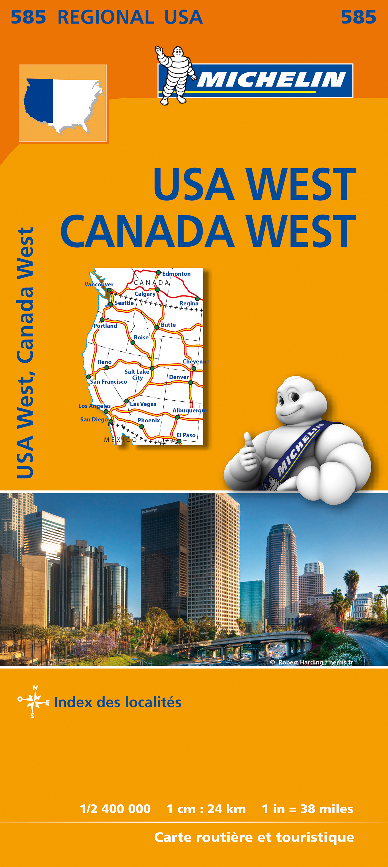
Hema’s Great Desert Tracks Map Pack The Great Desert Tracks Map Pack presents Hema's iconic Great Desert Tracks series in a soft and durable map wallet. Explore the arid centre with these comprehensive maps that traverse Australia's desert regions — each map waterproof, tear proof and field-checked by the Hema Map Patrol to ensure the accuracy and detail necessary for desert travel. With complete coverage of the outback region of Australia's centre, the Great Desert Tracks Map Pack is the perfect navigation guide for every desert track and journey throughout Australia.


Included in each map pack:


• Great Desert Tracks Central Sheet  


• Great Desert Tracks Eastern Sheet  


• Great Desert Tracks Western Sheet  


• Great Desert Tracks Simpson Desert  


• Map Wallet  


Great Desert Tracks Eastern Sheet: Oodnadatta Track, Birdsville Track, Simpson Desert, Strzelecki Track, Corner Country, Broken Hill, Lake Eyre, Plenty Highway, Sandover Highway, Channel Country, Hay River Track etc


Great Desert Tracks Central Sheet: Goog's Track, Nullarbor Plain, Oodnadatta Track, Anne Beadell Highway, Tanami Road, Gary Junction Road, Sandy Blight Junction Track etc


Great Desert Tracks Simpson Desert: The whole of the Simpson Desert with GPS-surveyed roads and tracks


Great Desert Tracks Western Sheet: Gunbarrel Highway, Great Central Road, Connie Sue Highway, Nullarbor Plain, Canning Stock Route, Talawana Track, Great Sandy Desert etc.


Map features are:

Double-sided maps

Details and map references for interesting places

Handy phone numbers and web addresses for permits

Field-checked by Hema Map Patrol

Field-checked 4WD Tracks

Permit & contact details

GPS surveyed roads & tracks

Fuel & provision availability

Maps printed on waterproof & tear-proof paper

New relief shading & elevation tinting gives a more realistic interpretation of the landscape

€ 13.95
Wegenkaart - landkaart Albanië - Albanien | Reise Know-How Verlag

Tweetalige kaart (Engels en Duits). Door ingetekende lengte- en breedtegraden is het gebruik van GPS mogelijk. Met hoogtelijnen en uitgebreid wegennetwerk: daarnaast worden ook de afstanden tussen belangrijke plaatsen duidelijk leesbaar weergegeven. Het kleurgebruik is zodanig dat je een goede indruk krijgt van hoogteverschillen en soorten landschap. Natuurlijk staan de toeristische bezienswaardigheden duidelijk vermeld.


Gedrukt op water- en scheurvast papier! Polyart is een synthetisch product vrij van giftige stoffen dus duurzaam. Het papier gaat echt lang mee.


Topography is indicated by altitude colouring with numerous spot heights and names of mountain ranges and passes. Salt lakes, swamps, seasonal rivers and glacier are also shown. Detailed presentation of the road network includes minor roads and tracks and railways are also shown.


Internal administrative units are presented with their boundaries and names. National parks and other protected areas are highlighted. A wide range of symbols mark various places of interest. Map legends include English and all the maps have an index of localities.

€ 10.25
Stadsplattegrond Cape Town - Kaapstad | Borch

Borch Kaapstad is een duidelijke, geplastificeerde plattegrond van het centrum met informatie over openbaar vervoer en bezienswaardigheden. Inclusief straatnamenregister.


Our soft-laminated folded map of Cape Town shows: Cape Town 1:15 000, Cape Peninsula 1:140 000, Cape Town and Region 1:635 000, Garden Route 1:3 000 000, Robben Island 1:40 000, South Africa administrative & time zones, Public Transport Cape Town. Borch Maps are easy to fold, durable and water-repellent with a wipeable surface. Borch Maps show hotels, museums, monuments, markets, public transport, top sights and points of interest, useful statistics, conversion charts for temperatures, weights and measurements, climate charts showing temperatures, sunshine hours, precipitation and humidity, overview maps, time zones, and much more...


Cape Town, the legislative capital and second most populous city of South Africa and the provincial capital of the Western Cape, is also renowned as one of the world's most beautiful cities. South Africa's most popular tourist region covers almost 2,500 sq km (500 sq km of which is the city of Cape Town), has a relatively low population density, an agreeable Mediterranean climate and a flourishing economy with well-developed infrastructure. First inhabited about 12,000 years ago and colonized by Europeans in the 15th century, Cape Town underwent centuries of successive occupation before becoming today's democratic capital. Because of Cape Town's splendid natural surroundings and outdoor lifestyle, day trips to the countless natural sights can be enjoyed by everyone and visitors can participate in many activities - from surfing or whale and dolphin-watching to visiting the national parks, hiking (or taking a cable-car) up Table Mountain or embarking on a wine-tasting trip into the Cape Winelands. You'll find the nightlife and restaurants are excellent and this city boasts great shopping venues, beautiful architecture, friendly locals and above all stunning scenery.


€ 17.50
Wegenkaart - landkaart 3405 Adventure Map Colombia | National Geographic

Wegenkaart van Colombia met vermelding van veel bezienswaardigheden, nationale parken en attrakties. Watervast en scheurvast. Juist door deze vermeldingen onderscheidt de kaart zich van andere wegenkaarten.


National Geographic's Colombia Adventure Map is designed to meet the unique needs of adventure travelers with its durability and accurate information. Each folded map provides global travelers with the perfect combination of detail and perspective, highlighting the area’s terrain and best locations for adventure activities like snorkeling, surfing, fishing, and more. Adventure Maps include hundreds of points of interest that highlight diverse and unique destinations within the country.


The map includes the locations of thousands of cities and towns with a user-friendly index, plus a clearly marked road network complete with distances and designations for major highways, main roads, and tracks and trails for those seeking to explore more remote regions.


Key Features:

Waterproof and tear-resistant

Detailed interpretive information and local travel tips

Detailed topography complete with activity symbols, ideal for exploring the country

City overview maps

Hundreds of points of interest, including the location of World Heritage sites, national parks and nature reserves, aboriginal settlements and protected lands, mines, archeological sites, wildlife parks and more

Thousands of place names

Important travel aids including airports, lighthouses, ferry routes and rail lines

Developed in cooperation with local agencies

Updated regularly to ensure accuracy

€ 9.95
Wegenkaart - landkaart 371 West Vlaanderen | Michelin

Heel duidelijke wegenkaart van deze bepaalde provincie in België. Alle dorpen staan er op vermeld. Met uitgebreide legenda en register. Daarnaast zijn van de belangrijkste steden kleine plattegronden bijgevoegd. Bedenk wel dat deze kaart alleen daadwerkelijk de provincie weergeeft, juist de randen van de kaart worden gebruikt voor andere inzetten als genoemde plattegronden. Er worden geen fietspaden of campings op vemeld, wel zijn bijvoorbeeld bosgebieden er op te vinden.

€ 9.95
Wegenkaart - landkaart 373 Antwerpen - Anvers | Michelin

Heel duidelijke wegenkaart van deze bepaalde provincie in België. Alle dorpen staan er op vermeld. Met uitgebreide legenda en register. Daarnaast zijn van de belangrijkste steden kleine plattegronden bijgevoegd. Bedenk wel dat deze kaart alleen daadwerkelijk de provincie weergeeft, juist de randen van de kaart worden gebruikt voor andere inzetten als genoemde plattegronden. Er worden geen fietspaden of campings op vemeld, wel zijn bijvoorbeeld bosgebieden er op te vinden.

€ 9.95
Wegenkaart - landkaart 376 Liège - Luik | Michelin

Heel duidelijke wegenkaart van deze bepaalde provincie in België. Alle dorpen staan er op vermeld. Met uitgebreide legenda en register. Daarnaast zijn van de belangrijkste steden kleine plattegronden bijgevoegd. Bedenk wel dat deze kaart alleen daadwerkelijk de provincie weergeeft, juist de randen van de kaart worden gebruikt voor andere inzetten als genoemde plattegronden. Er worden geen fietspaden of campings op vemeld, wel zijn bijvoorbeeld bosgebieden er op te vinden.

€ 13.50
Wegenkaart - landkaart Icefields Parkway | Gem Trek Maps

Whether you have a day or a week to spend exploring the sights along the spectacular Icefields Parkway highway, Gem Trek's ICEFIELDS PAKRWAY MAP, a combination map and guide, will help you make the most of your time. Like our much-loved hiking maps, our Icefields Parkway map features detailed cartography and is printed on waterproof and tear-resistant paper.


The Icefields Parkway Map shows all viewpoints, picnic areas, trailheads, campgrounds, hostels, lodges and other services along the Icefields Parkway, while the descriptions in the guide point you to the best of these - the best viewpoints of mountains and lakes, the most interesting points of interest and exhibits, and the best bets for spotting wildlife such as moose, bighorn sheep and mountain goats.


Also included are short descriptions of the ten best walks and day hikes along the Icefields Parkway—from the short stroll to Peyto Lake Viewpoint to the rewarding hike through alpine meadows to Helen Lake.


To make it easier to plan your day, we've also provided information about campgrounds, lodges, visitor centres and other key services along the Icefields Parkway. A mileage chart, area map and elevation profile complete the map.


Icefields Parkway Map Coverage

The Icefields Parkway Map covers the entire length of the Icefields Parkway, a 232-kilometre (144-mile) route between the village of Lake Louise and the town of Jasper. The route traverses some of the world’s most spectacular mountain scenery and is a highlight of any trip to the Canadian Rockies.


For ease of use, we have divided the Icefields Parkway into two sections: on one side of the map is the southern section between Lake Louise and the Columbia Icefield, while the reverse side highlights the section between the Columbia Icefield and the town of Jasper.


Icefields Parkway Map Features

The Icefields Parkway Map includes:


contour lines at 25-metre (80-foot) intervals

relief shading to better show the topography

full colour on both sides

hiking trails

hydrology – rivers, rapids, glaciers, and waterfalls

mountain names and all available mountain elevations

all campgrounds

points of interest and attractions

picnic areas

highway viewpoints

€ 13.95
Wegenkaart - landkaart Spanje Noord - Sint Jacobsroute | Reise Know-How Verlag

Tweetalige kaart (Engels en Duits). Door ingetekende lengte- en breedtegraden is het gebruik van GPS mogelijk. Met hoogtelijnen en uitgebreid wegennetwerk: daarnaast worden ook de afstanden tussen belangrijke plaatsen duidelijk leesbaar weergegeven. Het kleurgebruik is zodanig dat je een goede indruk krijgt van hoogteverschillen en soorten landschap. Natuurlijk staan de toeristische bezienswaardigheden duidelijk vermeld.


Gedrukt op water- en scheurvast papier! Polyart is een synthetisch product vrij van giftige stoffen dus duurzaam. Het papier gaat echt lang mee.


The main route of the Way of St James from Pamplona, across Logroño, Burgos, León and Ponferrada is clearly marked. The map also shows the alterative coastal route and its variants. Various churches and monasteries along the route are highlighted.


Topography is indicated by altitude colouring with numerous spot heights and names of mountain ranges and passes. Salt lakes, swamps, seasonal rivers and glacier are also shown. Detailed presentation of the road network includes minor roads and tracks and railways are also shown.


Internal administrative units are presented with their boundaries and names. National parks and other protected areas are highlighted. A wide range of symbols mark various places of interest. Map legends include English and all the maps have an index of localities.

€ 10.25
Wegenkaart - landkaart 15 Agia Napa - Protaras - Paralimni | Orama

Goede - behoorlijk gedetailleerde - wegenkaart van een deel van Cyprus. Waar beschikbaar worden hotels en campings getoond en met symbolen worden allerhande toeristische symbolen aangeduid als historische plaatsen, kloosters, museas etc.  Tweetalig. Op elke kaart staat van de belangrijkste steden een centrumkaart en er is een behoorlijk uitgebreid register (wel kleine letters!) Kleurgebruik is duidelijk, maar een beetje flets, waardoor hoogteverschillen niet echt goed uitkomen. 

€ 14.95
Wegenkaart - landkaart IJsland - Island | Freytag & Berndt

Goede wegenkaart van IJsland met alle mogelijke details; genoeg voor een gewone vakantie en tour rond het eiland. Met veel toeristische informatie op de kaart in de vorm van symbolen, o.a. voor campings, geysers, musea. Kleine plattegrond van Reykjavik. Zuidwest IJsland wordt weergegeven op schaal 1:150.000

De berijdbare wegen zijn goed weergeven, zowel de hoofdwegen als provinciale en lokale wegen; wegnummers worden vermeld. Afstanden tussen plaatsen zijn in kilometers op de kaart ingetekend, daarnaast worden ook op belangrijke plekken benzinepompen gemarkeerd.

In het kaartbeeld wordt door middel van schaduw het reliëf weergegeven en soms enkele punten in het landschap met de daadwerkelijke hoogte. Provinciegrenzen zijn goed terug te vinden, nationale parken en reservaten ook. Met allerhande symbolen worden toeristische bezienswaardigheden weergegeven als monumenten, historisch belangrijke plekken en uitzichtpunten. In bepaalde plaatsen zijn hotels en campings te vinden, luchthavens, treinverbindingen en havens vindt u er ook op!

van de uitgever
Die Straßen- und Freizeitkarte Island im Maßstab 1:400.000 bietet Reisenden, die die atemberaubende Schönheit Islands erleben möchten, viele nützliche Informationen. Mit einer Straßenkarte von freytag & berndt können Auto- und Motorradfahrer Island sicher und effizient erkunden, unabhängig davon, ob sie auf den Hauptstraßen bleiben oder abenteuerliche Routen auf Nebenstraßen wählen.

Das gesamte Straßennetz der Insel ist auf der Karte exakt dargestellt, zudem sind viele Ausflugsziele und Sehenswürdigkeiten, wie Geysire und Möglichkeiten zur Walbeobachtung in der Karte eingezeichnet. Wohnwagenfahrer und Camper finden in der Karte natürlich alle Campingplätze und Stellplätze.

Informationen zur Straßenkarte Island

Maßstab 1:400.000

Golden Circle 1:150.000

Stadtplan Reykjavík 1:20.000

Whale Watching, Aussichtspunkte

Campingplätze und Stellplätze

Ortsregister mit Postleitzahlen

Format: 135 x 98,5 cm

Auf der Rückseite der Autokarte findet sich neben einem Stadtplan von Reykjavik eine Detailkarte der Halbinsel Reykjanes mit dem Golden Circle im Maßstab 1:150.000. Im Südwesten Islands gelegen finden sich dort zahlreiche geothermische Highlights wie heiße Quellen, Schlammbecken und dampfende Fumarolen, sowie beeindruckende Landschaften entlang der Küste und faszinierende historische Stätten wie das Fischerdorf Grindavik und der Leuchtturm Reykjanesviti.

Eines der beliebtesten Ausflugsziele auf Island ist der Nationalpark Thingvellir. Hier können Besucher die atemberaubende Schönheit des Silfra-Bruchs bewundern. Ein weiteres Highlight ist der Gullfoss-Wasserfall, der mit seinen mächtigen Kaskaden beeindruckt.

€ 14.95
Wegenkaart - landkaart India - Nepal - Bangladesh - Bhutan - Sri Lanka | Freytag & Berndt

Gedetailleerde, eenzijdige landkaart van het Indiase subcontinent, prima geschikt voor planning en rondtrekken . De berijdbare wegen zijn goed weergeven, zowel de hoofdwegen als provinciale en lokale wegen; wegnummers worden vermeld. Afstanden tussen plaatsen zijn in kilometers op de kaart ingetekend, daarnaast worden ook op belangrijke plekken benzinepompen gemarkeerd.

In het kaartbeeld wordt door middel van schaduw het reliëf weergegeven en soms enkele punten in het landschap met de daadwerkelijke hoogte. Provinciegrenzen zijn goed terug te vinden, nationale parken en reservaten ook. Met allerhande symbolen worden toeristische bezienswaardigheden weergegeven als monumenten, historisch belangrijke plekken en uitzichtpunten. 

€ 13.95
Wegenkaart - landkaart Westelijke Balkan - Westliche Balkanregion | Reise Know-How Verlag

Tweetalige kaart (Engels en Duits). Door ingetekende lengte- en breedtegraden is het gebruik van GPS mogelijk. Met hoogtelijnen en uitgebreid wegennetwerk: daarnaast worden ook de afstanden tussen belangrijke plaatsen duidelijk leesbaar weergegeven. Het kleurgebruik is zodanig dat je een goede indruk krijgt van hoogteverschillen en soorten landschap. Natuurlijk staan de toeristische bezienswaardigheden duidelijk vermeld.


Gedrukt op water- en scheurvast papier! Polyart is een synthetisch product vrij van giftige stoffen dus duurzaam. Het papier gaat echt lang mee.


Topography is indicated by altitude colouring with numerous spot heights and names of mountain ranges and passes. Salt lakes, swamps, seasonal rivers and glacier are also shown. Detailed presentation of the road network includes minor roads and tracks and railways are also shown.


Internal administrative units are presented with their boundaries and names. National parks and other protected areas are highlighted. A wide range of symbols mark various places of interest. Map legends include English and all the maps have an index of localities.

€ 14.95
Wegenkaart - landkaart Azoren - Azores | Freytag & Berndt

Uitstekende wegenkaart van de Azoren. Met index, toeristische informatie, Autoveerboten en jachthavens. Elk eiland op een aparte inzet.

Gedetailleerde landkaart, ook te gebruiken als wandelkaart of fietskaart van de Azoren (Acores, Portugal) schaal 1:50.000 met uitgebreide legenda en plaatsnamenregister.

This large double-sided road map of the Azores, at 1:50,000 from Freytag & Berndt, shows the islands both individually and as a group and comes with an attached index and concise leisure guide booklet. 


This map shows main and minor roads, motorways and toll roads, sections under construction or closed to traffic. Conveniently highlighted are scenic routes, gradients on steep roads, driving distances in kilometres, petrol and service stations etc. Railway lines are marked and international and local airports are indicated as well as ferry connections to the other islands. 


Relief shading, spot heights and colouring and/or graphics provide a good presentation of the islands topography. Natural reserves are marked and symbols indicate various places of interest and facilities, e.g. museums, churches and castles, viewpoints, beaches, campsites and motels, etc. Latitude and longitude lines are drawn at 2' intervals. 


A small inset shows the islands together as a group and ferry and domestic airlines connection within the islands.


The multilingual booklet, which includes English, contains an index listing all the localities with their postcodes and GPS coordinates and a brief description of main tourist sights.

€ 11.50
Wegenkaart - landkaart Servië, Montenegro & Kosovo | Reise Know-How Verlag

Tweetalige kaart (Engels en Duits). Door ingetekende lengte- en breedtegraden is het gebruik van GPS mogelijk. Met hoogtelijnen en uitgebreid wegennetwerk: daarnaast worden ook de afstanden tussen belangrijke plaatsen duidelijk leesbaar weergegeven. Het kleurgebruik is zodanig dat je een goede indruk krijgt van hoogteverschillen en soorten landschap. Natuurlijk staan de toeristische bezienswaardigheden duidelijk vermeld.


Gedrukt op water- en scheurvast papier! Polyart is een synthetisch product vrij van giftige stoffen dus duurzaam. Het papier gaat echt lang mee.


Topography is indicated by altitude colouring with numerous spot heights and names of mountain ranges and passes. Salt lakes, swamps, seasonal rivers and glacier are also shown. Detailed presentation of the road network includes minor roads and tracks and railways are also shown.


Internal administrative units are presented with their boundaries and names. National parks and other protected areas are highlighted. A wide range of symbols mark various places of interest. Map legends include English and all the maps have an index of localities.

€ 13.95
Wegenkaart - landkaart Mali | ITMB

Een degelijke kaart met aanduidingen van o.a. nationale parken, vliegveld, benzinepomp, dirt-roads en kleine plattegrond van hoofdstad. Als overzichtskaart goed te gebruiken.


Folded road and travel map in color. Scale 1:2,400,000. Distinguishes roads ranging from primary paved roads to other roads or tracks. Legend includes international airport/national airports, air fields, gasoline/petrol stations, post office, hospital/medical facilities, hotels, motels/lodging, resthouse or hostel, campsites or huts, museums, border crossings, no border crossings, points of interest, crafts/pottery, archaelogical sites, historic ruins or sites, mines, bus station, forts, mosques, churches/missions, oasis, caves, fishing ports, beaches, hiking/trekking. Includes inset map of Bamako and Timbuktu, road distance chart and extensive index.

€ 11.95
Wegenkaart - landkaart 712 Ierland | Michelin

Zoals je van Michelin mag verwachten is deze kaart zeer overzichtelijk en heeft een duidelijk helder kaartbeeld. De kaart geeft uitgebreid toeristische informatie weer. Met register, afstanden en reistijden.

Wegen worden naar verschillende klasse ingedeeld en - mooi van Michelin - de interessante mooie routes worden gemarkeerd met een groene streep. 


Hindernissen voor automobilisten met caravans zijn gemarkeerd: steile hellingen, bergpassen of een anderzins moeilijke route. Bezienswaardigheden als een kasteel, religieus gebouw, ruine of grot is door een symbool goed te vinden.


This Ireland map from Michelin is part of their red national map series. These are perfect for route planning as well as getting around by car once you're there. They clearly mark out major roads and also show many of the more important minor roads. A couple of insets showing enlargements of Dublin and environs at 1:120 000 and Belfast and environs, also at 1:120 000, are included.


The map's simple folding design with durable paper cover, allows it to be read like a book and easily folded back together. Road numbers and intermediate distances are clearly displayed with the more scenic routes highlighted in green.


The map also features:


Political boundaries

Regional and National Parks

Important sights such as castles, ruins, and churches

Driving Times and Distances

Road Safety Information

A legend in multiple languages (Dutch, English, French, German and Spanish)


Belfast, Cork, Derry/Londonderry, Dublin, Galway, Irlande, Killarney, Limerick, Waterford

€ 14.95
Wegenkaart - landkaart Côte d'Azur- Franse Riviera | Freytag & Berndt

Deze bijzonder gedetailleerde Freytag & Berndt Wegenkaart van de Cote d'Azur is aan één kant geprint en heeft een schaal van 1:150.000. Op deze kaart staan o.a. fietsroutes, lange afstandswandelpaden, toeristische wegen en bezienwaardigheden aangegeven. In de omslag van de kaart is een apart boekje geniet met een korte beschrijving van de TOP 10 van bezienswaardigheden, een uitgebreide index en plattegrondjes van enkele toeristische plaatsen.

Explore the French Riviera with this Freytag & Berndt road map. The best way to plan your trip, prepare your itinerary, and to travel independently in this country. As with all Freytag & Berndt maps the cartography is clear and detailed with the topography shown by relief shading with plenty of spot heights.


This map includes detailed land information of the French Riviera area, and also insets of major towns including Nice, Toulon, Cannes, Monte Carlo and more. Also included is a booklet of top tips of what to do and see when visiting there. 


Freytag & Berndt maps make good use of an icon system. Icons show tourist information such as:


Places of interest and entertainment

Lakes and rivers

Monuments and other archaeological sites


Distances between points are shown as well as indications of steep gradients, all distances are in kilometres. The legend is in several languages inlcuding English.

€ 15.95
Wegenkaart - landkaart Ukraine - Moldova | Gizi Map

Kaart van Oekraïne met Moldavië, met een uitbreiding met de Krim in meer detail, plus plattegronden van het centrum van Kiev en Lviv. Wegennet is ingedeeld in zes typen, rij-afstanden aangegeven op hoofd-en secundaire routes, en verder worden grensovergangen weergegeven.

Ukraine with Moldova on an indexed road map at 1:1,100,000 from Gizi Map, with an enlargement showing southern Crimea in greater detail, plus street plans of central Kiev and Lviv. All place names are shown transliterated into Latin alphabet, with those of major cities also given in their Cyrillic versions.

Altitude colouring with relief shading indicates the mountainous regions, with the marshlands of northern Ukraine also marked. National parks and other protected areas are highlighted. Road network is graded into six types, driving distances are marked on main and secondary routes, and border crossings are shown. Railway lines, ferry routes on the Black Sea and Azov Sea, and local airports are included. Symbols highlight various places of interest: historic sites, natural curiosities, etc. Also marked is the location of the nuclear power station at Chernobyl and the surrounding exclusion zone. Latitude and longitude lines are drawn at 1° intervals. Extensive index is on the reverse. Map legend includes English.


The map also provides:


- an enlargement presenting southern Crimea in greater detail at 1:500,000, including locations of campsites (not shown on the main map for the rest of the country)


- street plans of central Kiev and Lviv, annotated with places of interest and tourist accommodation

€ 11.50
Wegenkaart - landkaart Litauen | Reise Know-How Verlag

Tweetalige kaart (Engels en Duits) van Litouwen, inclusief plattegrond van Kaliningrad. Door ingetekende lengte- en breedtegraden is het gebruik van GPS mogelijk. Met hoogtelijnen en uitgebreid wegennetwerk: daarnaast worden ook de afstanden tussen belangrijke plaatsen duidelijk leesbaar weergegeven. Het kleurgebruik is zodanig dat je een goede indruk krijgt van hoogteverschillen en soorten landschap. Natuurlijk staan de toeristische bezienswaardigheden duidelijk vermeld.


Gedrukt op water- en scheurvast papier! Polyart is een synthetisch product vrij van giftige stoffen dus duurzaam. Het papier gaat echt lang mee.


Topography is indicated by altitude colouring with numerous spot heights and names of mountain ranges and passes. Salt lakes, swamps, seasonal rivers and glacier are also shown. Detailed presentation of the road network includes minor roads and tracks and railways are also shown.


Internal administrative units are presented with their boundaries and names. National parks and other protected areas are highlighted. A wide range of symbols mark various places of interest. Map legends include English and all the maps have an index of localities.


€ 9.95
Wegenkaart - landkaart 372 Oost Vlaanderen | Michelin

Heel duidelijke wegenkaart van deze bepaalde provincie in België. Alle dorpen staan er op vermeld. Met uitgebreide legenda en register. Daarnaast zijn van de belangrijkste steden kleine plattegronden bijgevoegd. Bedenk wel dat deze kaart alleen daadwerkelijk de provincie weergeeft, juist de randen van de kaart worden gebruikt voor andere inzetten als genoemde plattegronden. Er worden geen fietspaden of campings op vemeld, wel zijn bijvoorbeeld bosgebieden er op te vinden.

€ 9.95
Wegenkaart - landkaart 374 Vlaams Brabant provinciekaart | Michelin

Heel duidelijke wegenkaart van deze bepaalde provincie in België. Alle dorpen staan er op vermeld. Met uitgebreide legenda en register. Daarnaast zijn van de belangrijkste steden kleine plattegronden bijgevoegd. Bedenk wel dat deze kaart alleen daadwerkelijk de provincie weergeeft, juist de randen van de kaart worden gebruikt voor andere inzetten als genoemde plattegronden. Er worden geen fietspaden of campings op vemeld, wel zijn bijvoorbeeld bosgebieden er op te vinden.

€ 9.95
Wegenkaart - landkaart 375 Limburg | Michelin

Heel duidelijke wegenkaart van deze bepaalde provincie in België. Alle dorpen staan er op vermeld. Met uitgebreide legenda en register. Daarnaast zijn van de belangrijkste steden kleine plattegronden bijgevoegd. Bedenk wel dat deze kaart alleen daadwerkelijk de provincie weergeeft, juist de randen van de kaart worden gebruikt voor andere inzetten als genoemde plattegronden. Er worden geen fietspaden of campings op vemeld, wel zijn bijvoorbeeld bosgebieden er op te vinden.

€ 9.95
Wegenkaart - landkaart 378 Namur - Namen | Michelin

Heel duidelijke wegenkaart van deze bepaalde provincie in België. Alle dorpen staan er op vermeld. Met uitgebreide legenda en register. Daarnaast zijn van de belangrijkste steden kleine plattegronden bijgevoegd. Bedenk wel dat deze kaart alleen daadwerkelijk de provincie weergeeft, juist de randen van de kaart worden gebruikt voor andere inzetten als genoemde plattegronden. Er worden geen fietspaden of campings op vemeld, wel zijn bijvoorbeeld bosgebieden er op te vinden.

€ 11.50
Wegenkaart - landkaart 18 Marco Polo Freizeitkarte Harz | MairDumont

Regionale kaart met veel praktische informatie als campings, bezienswaardigheden, fietsroutes etc. Een handige kaart als je vanuit een bepaalde standplaats de omgeving wilt verkennen. Geplastificeerd!

Zoals op het overzicht te zien is, blijkt niet heel Duitsland gedekt door deze serie. Zo zijn de landsgrenzen met Nederland niet in kaart gebracht door Marco Polo. Kijk dus goed op het overzicht hoe deze kaart uitgesneden is.


Im praktischen Set: Freizeitkarte und Freizeitführer für die schönsten Ausflüge für Freizeit und Familie.


* 66 spannende Freizeittipps.

* 8 bis 10 abwechslungsreiche Radtouren

* Viele Symbole zeigen die Sehenswürdigkeiten

* Ausführliche Beschreibung der Freizeittipps.

* Detailierte Beschreibung der Radtouren


Freizeitkarte:

66 Tipps sind in der Karte farblich nach Themen gekennzeichnet, am Kartenrand als Kurz-Orientierung durch Bild und Text erklärt und im Extra Guide ausführlich beschrieben. Mit Tipps zu Erlebnis, Natur und Kultur und 20-30 in der Karte eingezeichneten Wanderparkplätzen. Zusätzliche Hinweise am Kartenrand. Empfehlungen für Familien mit Kindern und Empfehlungen bei Schlechtwetter .

Der Extra Guide:

Im Extra Guide sind die 66 Tipps aus der Karte beschrieben. Zusätzlich enthalten und in der Karte eingezeichnet sind ca. 10 Fahrradtouren und ca. 20-30 Biergärten und Ausflugslokale.

€ 17.50
Wegenkaart - landkaart 3110 Adventure Map Guatemala | National Geographic

Wegenkaart van Guatemala met vermelding van veel bezienswaardigheden, nationale parken en attrakties. Watervast en scheurvast. Juist door deze vermeldingen onderscheidt de kaart zich van andere wegenkaarten.


National Geographic's Guatemala Adventure Map is designed to meet the unique needs of adventure travelers with its durability and accurate information. Each folded map provides global travelers with the perfect combination of detail and perspective, highlighting the area’s terrain and best locations for adventure activities like snorkeling, surfing, fishing, and more. Adventure Maps include hundreds of points of interest that highlight diverse and unique destinations within the country.


The map includes the locations of thousands of towns and natural features with a user-friendly index, plus a clearly marked road network complete with distances and designations for major highways, main roads, and tracks and trails for those seeking to explore more remote regions.


Key Features:

Waterproof and tear-resistant

Detailed interpretive information and local travel tips

Detailed topography complete with activity symbols, ideal for exploring the country

City overview maps

Hundreds of points of interest, including the location of World Heritage sites, national parks and nature reserves, aboriginal settlements and protected lands, mines, archeological sites, wildlife parks and more

Thousands of place names

Important travel aids including airports, lighthouses, ferry routes and rail lines

Developed in cooperation with local agencies

Updated regularly to ensure accuracy

Printed in the U.S.


€ 14.95
Wegenkaart - landkaart Frankrijk zuid - Frankreich sud | Freytag & Berndt

Gedetailleerde, tweezijdige landkaart van Zuid Frankrijk, prima geschikt voor planning en rondtrekken door het land. De berijdbare wegen zijn goed weergeven, zowel de hoofdwegen als provinciale en lokale wegen; wegnummers worden vermeld. Afstanden tussen plaatsen zijn in kilometers op de kaart ingetekend, daarnaast worden ook op belangrijke plekken benzinepompen gemarkeerd.


In het kaartbeeld wordt door middel van schaduw het reliëf weergegeven en soms enkele punten in het landschap met de daadwerkelijke hoogte. Provinciegrenzen zijn goed terug te vinden, nationale parken en reservaten ook. Met allerhande symbolen worden toeristische bezienswaardigheden weergegeven als monumenten, historisch belangrijke plekken en uitzichtpunten. In bepaalde plaatsen zijn hotels en campings te vinden, luchthavens, treinverbindingen en havens vindt u er ook op!


Van de uitgever

freytag & berndt Autokarten sind für viele Länder und Regionen weltweit erhältlich. Neben der übersichtlichen Gestaltung verfügt die Straßenkarte "Frankreich Süd 1:500.000" über zahlreiche Zusatzinformationen wie z.B. Straßenbeschaffenheit, Sehenswürdigkeiten und Campingplätze. Mit dem umfangreichen Ortsregister gelingt zudem eine rasche Orientierung. Touristische Informationen, Entfernungen in km, Ortsregister mit Postleitzahlen, doppelseitig;

€ 11.50
Wegenkaart - landkaart Grönland - Groenland | Reise Know-How Verlag

Tweetalige kaart (Engels en Duits). Door ingetekende lengte- en breedtegraden is het gebruik van GPS mogelijk. Met hoogtelijnen en uitgebreid wegennetwerk: daarnaast worden ook de afstanden tussen belangrijke plaatsen duidelijk leesbaar weergegeven. Het kleurgebruik is zodanig dat je een goede indruk krijgt van hoogteverschillen en soorten landschap. Natuurlijk staan de toeristische bezienswaardigheden duidelijk vermeld.


Gedrukt op water- en scheurvast papier! Polyart is een synthetisch product vrij van giftige stoffen dus duurzaam. Het papier gaat echt lang mee.


Topography is indicated by altitude colouring with numerous spot heights and names of mountain ranges and passes. Salt lakes, swamps, seasonal rivers and glacier are also shown. Detailed presentation of the road network includes minor roads and tracks and railways are also shown.


Internal administrative units are presented with their boundaries and names. National parks and other protected areas are highlighted. A wide range of symbols mark various places of interest. Map legends include English and all the maps have an index of localities.


€ 14.95
Wegenkaart - landkaart Noord Servië - Serbien Noord | Freytag & Berndt

Uitstekende landkaart van Noord Servië. Met index, toeristische informatie en afstanden in kilometers.

Gedetailleerde, tweezijdige landkaart van dit gebied, prima geschikt voor planning en rondtrekken. De berijdbare wegen zijn goed weergeven, zowel de hoofdwegen als provinciale en lokale wegen; wegnummers worden vermeld. Afstanden tussen plaatsen zijn in kilometers op de kaart ingetekend, daarnaast worden ook op belangrijke plekken benzinepompen gemarkeerd.

In het kaartbeeld wordt door middel van schaduw het reliëf weergegeven en soms enkele punten in het landschap met de daadwerkelijke hoogte. Provinciegrenzen zijn goed terug te vinden, nationale parken en reservaten ook. Met allerhande symbolen worden toeristische bezienswaardigheden weergegeven als monumenten, historisch belangrijke plekken en uitzichtpunten. In bepaalde plaatsen zijn hotels en campings te vinden, luchthavens, treinverbindingen en havens vindt u er ook op!

€ 15.95
Wegenkaart - landkaart Kyrgyzstan - Kirgizië | Gizi Map

Met name door het kleurgebruik een mooie kaart: heel duidelijk wordt het landschap weergegeven. Daarnaast veel topografische details.


Kyrgyzstan at 1:750,000 from Gizi Map with excellent presentation of the country’s mountainous terrain through bold altitude colouring and plenty of names of mountain ranges, etc, road network indicating routes of the old Silk Road, plus a street plan of Bishkek and an administrative map of the country. All place names are in the Latin alphabet.


Topography is vividly shown by bold elevation colouring, with spot heights and graphics for swamps, salt flats and deserts, plus plenty of names of mountain ranges, peaks, valleys, etc. National parks are highlighted. The map shows internal provincial boundaries and also clearly indicates the country’s Uzbek and Tadjik enclaves. Road network includes selected local tracks and highlights routes which used to the part of the old Silk Road. Railway lines are included and local airports are marked. Symbols indicate various places of interest, locations with tourist accommodation including yurt camps, etc. Latitude and longitude lines are drawn at 30’ intervals. The map has on the reverse two separate but cross-referenced indexes, in Latin and Cyrillic script. Map legend includes English.


Two panels provide a street plan of central Bishkek annotated with important buildings, selected hotels and places of interest, plus a small administrative map of the country.


€ 13.95
Wegenkaart - landkaart Denemarken | Reise Know-How Verlag

Tweetalige kaart (Engels en Duits). Door ingetekende lengte- en breedtegraden is het gebruik van GPS mogelijk. Met hoogtelijnen en uitgebreid wegennetwerk: daarnaast worden ook de afstanden tussen belangrijke plaatsen duidelijk leesbaar weergegeven. Het kleurgebruik is zodanig dat je een goede indruk krijgt van hoogteverschillen en soorten landschap. Natuurlijk staan de toeristische bezienswaardigheden duidelijk vermeld.


Gedrukt op water- en scheurvast papier! Polyart is een synthetisch product vrij van giftige stoffen dus duurzaam. Het papier gaat echt lang mee.


Topography is indicated by altitude colouring with numerous spot heights and names of mountain ranges and passes. Salt lakes, swamps, seasonal rivers and glacier are also shown. Detailed presentation of the road network includes minor roads and tracks and railways are also shown.


Internal administrative units are presented with their boundaries and names. National parks and other protected areas are highlighted. A wide range of symbols mark various places of interest. Map legends include English and all the maps have an index of localities.

€ 11.50
Wegenkaart - landkaart 22 Marco Polo Freizeitkarte Thüringer Wald | MairDumont

Regionale kaart met veel praktische informatie als campings, bezienswaardigheden, fietsroutes etc.  Een handige kaart als je vanuit een bepaalde standplaats de omgeving wilt verkennen. Deze versie is geplastificeerd!


Zoals op het overzicht te zien is, blijkt niet heel Duitsland gedekt door deze serie. Zo zijn de landsgrenzen met Nederland niet in kaart gebracht door Marco Polo. Kijk dus goed op het overzicht hoe deze kaart uitgesneden is


Die reiß- und wetterfeste Karte enthält 66 Freizeit-Tipps, die am Kartenrand kurz beschrieben werden. Karte im Maßstab 1:100 000 mit Biergärten und Ausflugslokalen, Hofläden und Direktvermarktern sowie zehn Fahrradtouren.

€ 17.50
Wegenkaart - landkaart 3401 Adventure Map Brazil - Brazilië | National Geographic

Wegenkaart van Brazilië met vermelding van veel bezienswaardigheden, nationale parken en attrakties. Watervast en scheurvast. Juist door deze vermeldingen onderscheidt de kaart zich van andere wegenkaarten.

National Geographic s Brazil AdventureMap is designed to meet the unique needs of adventure travelers detailed, durable, and accurate. Brazil includes the locations of thousands of major cities and towns with an index for easily locating them, plus a clearly marked road network complete with distances and designations for major highways, limited access highways, tollways, and more. 


What sets National Geographic AdventureMaps apart from traditional road maps are the hundreds of points-of-interest that highlight the diverse, unique, and exotic destinations within Brazil including national parks and reserves, World Heritage sites, archeological sites, indigenous areas, churches, zoos, and museums. 


The front side of the Brazil map includes the western half of the country and features the remarkable Amazon Basin and the Mato Grosso Plateau. Airports, airfields, anchorages, and other travel aids are invaluable for adventurers seeking to explore the tropical rainforests, savannahs, and woodlands at the heart of the country s interior. The eastern half of the country is covered on the back side of the map, including the capital of Brasilia and the cities of São Paulo, Rio de Janeiro, Salvador, Fortaleza, Curitiba, Porto Alegre, and more. Harbors, lighthouses, and cruise routes are noted along Brazil's extensive Atlantic coastline. 

€ 9.95
Wegenkaart - landkaart 138 Martinique | Michelin

Speciale toeristische kaart van Martinique, gemaakt voor een goed bezocht gebied en uitvergroot. Daardoor zeer prettig leesbaar met een hoog nivo wat we van Michelin al veel langer gewend zijn. Alle wegen staan er op, met verschillende kleuren voor de aparte soorten wegen. Verder veel aandacht met symbolen voor de bezienswaardigheden in de regio, de bekende groene stroken naast de mooie wegen.

Fort-de-France, Grand'Rivière, Martinique, Ste-Anne

€ 17.50
Wegenkaart - landkaart 3400 Adventure Map Argentina - Argentinië | National Geographic

Wegenkaart van Argentinië met vermelding van veel bezienswaardigheden, nationale parken en attrakties. Watervast en scheurvast. Juist door deze vermeldingen onderscheidt de kaart zich van andere wegenkaarten.

National Geographic's Argentina Adventure Map is designed to meet the unique needs of adventure travelers—detailed, durable, and accurate. Argentina includes the locations of thousands of major cities and towns with an index for easily locating them, plus a clearly marked road network complete with distances and designations for major highways, limited access highways, minor roads, and more.


What sets National Geographic Adventure Maps apart from traditional road maps are the hundreds of points-of-interest that highlight the diverse, unique, and exotic destinations within Argentina including national parks and preserves, World Heritage sites, archeological sites, churches of interest, scenic viewpoints, natural points of interest, and important travel aids like airports, airstrips, rail lines, lighthouses, and harbors.


The north side of the Argentina map details the most highly populated areas of the country including the provinces of Buenos Aires, Córdoba, and Santa Fe as well as the impressive landscape of the Cordillera de los Andes bordering Chile on the northwest. Vineyards in Mendoza, Argentina’s world-renowned wine producing province are included, as are ski areas in this popular tourist region. An inset map shows the small province of Misiones that juts into the neighboring countries of Brazil and Paraguay. The south side of the map details Argentina’s extensive coastline from Mar Del Plata to Tierra Del Fuego highlighting beaches, preserves, and areas noted for fishing and surfing.


Popular places included on the map: Patagonia, Los Glaciares National Park, Península Valdés, Iguazú Falls, Andes Mountains, Puente del Inca, Quebrada de Humahuaca and The Pampas.

€ 9.95
Wegenkaart - landkaart 379 Henegouwen - Hainaut | Michelin

Heel duidelijke wegenkaart van deze bepaalde provincie in België. Alle dorpen staan er op vermeld. Met uitgebreide legenda en register. Daarnaast zijn van de belangrijkste steden kleine plattegronden bijgevoegd. Bedenk wel dat deze kaart alleen daadwerkelijk de provincie weergeeft, juist de randen van de kaart worden gebruikt voor andere inzetten als genoemde plattegronden. Er worden geen fietspaden of campings op vemeld, wel zijn bijvoorbeeld bosgebieden er op te vinden.

€ 11.75
Wegenkaart - landkaart Peru | Mapas Naturismo


Our new Peru map is ready and it´s fantastic. It´s the best map of Peru available on the market.


Highlights are:


important and historic sites, museums and other important places 

all the nature reserves

advices for ornithologists and botanicans

exact distance kilometers, fuel stations, hotels, panoramic routes for self drivers

some of most important local folk festivals

€ 17.50
Wegenkaart - landkaart 3000 Adventure Map Nepal | National Geographic

Wegenkaart van Nepal met vermelding van veel bezienswaardigheden, nationale parken en attrakties. Watervast en scheurvast.

National Geographic's Nepal Adventure Map is the most authoritative map for touring the country. Each waterproof and tear-resistant map provides travelers with the perfect combination of detail and perspective, highlighting points of interest for those venturing outside city centers.


This durable, folded map includes the locations of cities and towns with a user-friendly index, plus a clearly marked road network complete with distances and designations for major highways, main roads, and tracks and trails for those seeking to explore more remote regions.


The front side offers a detailed topographic and trekking map of central and eastern Nepal, including border regions with China and India. Mountaineers will stay on course with marked trails through the Himalayan Range, including Everest (the tallest mountain in the world), and the surrounding national parks and wildlife reserves. An inset of the Himalayas has been annotated to show elevation.


The backside includes the western portion of Nepal, from the city of Mahendranagar in the west, to the Shey-Phoksundo National Park and Dhorpatan Hunting Reserve in the east. A detailed inset of Kathmandu and Patan City provide valuable locations of goods and services for casual tourists and seasoned trekkers alike, including archeological sites, monasteries, kayaking opportunities, mountain bike paths, and campsites.


Key Features:

Waterproof and tear-resistant

Detailed interpretive information and local travel tips

Detailed topography complete with activity symbols, ideal for exploring the country

City overview maps

Hundreds of points of interest, including the location of World Heritage sites, national parks and nature reserves, aboriginal settlements and protected lands, mines, archeological sites, wildlife parks and more

Thousands of place names

Important travel aids including airports, lighthouses, ferry routes and rail lines

Developed in cooperation with local agencies

Updated regularly to ensure accuracy

€ 15.95
Wegenkaart - landkaart Mongolia - Mongolië | Gizi Map

Tweetalige kaart

A folded road map covering covering all of Mongolia, as well as parts of the surrounding countries. Subtle relief shading and spot heights show the topography. Road detail is good including many minor tracks, intermediate road distances are also shown in kilometres on the bigger roads.


Various places of interest are marked out including airports, monuments, ruins, administrative boundaries and national parks All place names are written in roman script, with bigger towns also in cyrillic. The extensive index included on the back of the map gives all place names in roman and cyrillic script. 


An inset showing a street map of the capital, Ulaan Baatar, at 1:30 000 is also included.


The legend is in 7 languages including English.

€ 17.50
Wegenkaart - landkaart 3502 Adventure Map Australia East - Australië Oost | National Geographic

Wegenkaart van Australië Oost met vermelding van veel bezienswaardigheden, nationale parken en attrakties. Watervast en scheurvast. Juist door deze vermeldingen onderscheidt de kaart zich van andere wegenkaarten.

National Geographic's Australia East AdventureMapis designed to meet the unique needs of adventure travelers with its durability and detailed, accurate information. The map includes the locations of thousands of cities and towns with a user-friendly index, plus a clearly marked road network complete with distances and designations for major highways, main roads, plus tracks and trails for those seeking to explore more remote regions. 


The Australia East AdventureMap differs from a traditional road map because it includes hundreds of points of interest that highlight diverse and unique destinations within the country. National parks, World Heritage sites, caves, archeological sites, aboriginal settlements and protected lands are included, making it an invaluable resource to travelers hoping to experience all the history and culture Australia has to offer. Additional travel aids include the location of airports, lighthouses and ferry routes. 


The front side of the Australia East map details Queensland, the Great Barrier Reef, and more. The back side of the map details the southern portion of Queensland, including Brisbane, as well as New South Wales and Victoria. An inset map of Tasmania is also included. The Australia AdventureMap is printed in the United States on a durable synthetic paper, making it waterproof, tear-resistant and tough capable of withstanding the rigors of international travel. 


Key Features:

Waterproof and tear-resistant

Detailed topography with clearly labeled natural features

Hundreds of points of interest, including the location of World Heritage sites, national parks and nature reserves, aboriginal settlements and protected lands, mines, archeological sites, wildlife parks and more

Thousands of place names with a detailed index

Important travel aids including airports, lighthouses, ferry routes and rail lines


€ 10.99
Wegenkaart - landkaart 4 Duitsland midden | ANWB Media

De ANWB heeft een grote serie wegenkaarten van de belangrijkste landen en streken. Het zijn echte overzichtskaarten van vaak een wat groter gebied. Deze keuze zorgt er voor dat de schaal vrij grof is en bepaalde details zijn weggelaten. De kleurstelling is een beetje flets waardoor je niet altijd even makkelijk onderscheid kan maken tussen verschillende landschappen of natuurlijke aspecten. 

Ook het register ontbreekt. Het grote voordeel is vaak dat het gebied op de kaart overeenkomt met de vraag van klanten. Voor het plannen van een vakantie een prima kaart!


Vergelijken met andere uitgevers van kaarten als Michelin, Freytag und Berndt of Reise KnowHow heeft de ANWB duidelijke keuzes gemaakt en gekozen voor een echte overzichtskaart. 

€ 14.95
Wegenkaart - landkaart Pyreneeën Landen | Freytag & Berndt

Uitstekende kaart van Pyreneeën Landen. Met index, toeristische informatie en afstanden in kilometers.

De berijdbare wegen zijn goed weergeven, zowel de hoofdwegen als provinciale en lokale wegen; wegnummers worden vermeld. Afstanden tussen plaatsen zijn in kilometers op de kaart ingetekend, daarnaast worden ook op belangrijke plekken benzinepompen gemarkeerd.

In het kaartbeeld wordt door middel van schaduw het reliëf weergegeven en soms enkele punten in het landschap met de daadwerkelijke hoogte. Provinciegrenzen zijn goed terug te vinden, nationale parken en reservaten ook. Met allerhande symbolen worden toeristische bezienswaardigheden weergegeven als monumenten, historisch belangrijke plekken en uitzichtpunten. In bepaalde plaatsen zijn hotels en campings te vinden, luchthavens, treinverbindingen en havens vindt u er ook op!

€ 10.95
Wegenkaart - landkaart Bali & Lombok | Nelles Verlag

Goede wegenkaart van Bali & Lombok. Aan beide kanten bedrukt. Met veel toeristische aanduidingen als nationale parken en culturele bezienswaardigheden. Prima leesbare kaart.

One of six maps in a series covering Indonesia, this is a folded road and tourist map of the two Indonesian islands of Bali and Lombok at 1:180 000 scale. Parks, beaches, and places of interest are all highlighted and shaded-relief coloyring clearly depicts the topography. 


The map includes insets showing Ubud and it's surroundings at 1:33 000, Denpasar at 1:20 000, Kuta at 1:20 000, Lovina Beach at 1:30 000, Sanur at 1:35 000, Nusa Dua at 1:50 000, the Gili Islands at 1:55 000, Mataram at 1:50 000 and an overview locator map. The legend is in English, French and German.


For over 20 years Nelles maps have been renowned throughout the world for their quality, faithfulness to detail and up-to-dateness. 


So that streets, ferry links, railway lines, etc are always up to date, Nelles are continuously upgrading their maps - with the help of their international team of correspondents. Roads are provided with an exact kilometerage. Sights are highlighted extra clearly so that you don't miss any tourist attractions.


A good map must be hard-wearing and allow itself to be folded up simply and quickly. Nelles Maps are a handy pocket size with the reliable, practical concertina fold. In addition they use an extra high-quality speciality paper resulting in considerably increased fold strength.

Gili Islands (Gili Trawangan. Gili Meno. Gili Air) 1 : 55.000
Ubud and Surroundings 1 : 33.000

Denpasar 1 : 20.000
Kuta / Legian 1 : 20.000
Lovina Beach 1 : 30.000
Mataram 1 : 50.000
Nusa Dua 1 : 50.000
Sanur 1 : 35.000


€ 13.95
Wegenkaart - landkaart Mexico Oaxaca & Chiapas & Guerrero | ITMB

Folded road and travel map, in color. Scale 1:700,000. Distinguishes roads ranging from expressways (free/toll) to rural roads. Legend includes tracks, trails, international airports, domestic airports, airfields, gas stations, points of interest, archaeological sites, caves, beaches, lighthouses, mines, national parks, swamps, mangroves. Includes inset map of Oaxaca City Downtown

Legend Includes:
Airports, roads by classifications, distances between points, gas station, point of interests, archaeological sites, beaches, lighthouses, hypsography and other information.

€ 11.99
Wegenkaart - landkaart Marokko | ANWB Media

De ANWB heeft een grote serie wegenkaarten van de belangrijkste landen en streken. Het zijn echte overzichtskaarten van vaak een wat groter gebied. Deze keuze zorgt er voor dat de schaal vrij grof is en bepaalde details zijn weggelaten. De kleurstelling is een beetje flets waardoor je niet altijd even makkelijk onderscheid kan maken tussen verschillende landschappen of natuurlijke aspecten. 

Ook het register ontbreekt. Het grote voordeel is vaak dat het gebied op de kaart overeenkomt met de vraag van klanten. Voor het plannen van een vakantie een prima kaart!


Vergeleken met andere uitgevers van kaarten als Michelin, Freytag und Berndt of Reise KnowHow heeft de ANWB duidelijke keuzes gemaakt en gekozen voor een echte overzichtskaart. 


MET DE ANWB WEGENKAART, WEET JE WAAR JE STAAT! ANWB wegenkaarten zijn een begrip in het land. Dat laten de verkoopcijfers ook zien. Afgelopen decennia zijn meer dan 10 miljoen kaarten over de toonbank gegaan. De wegenkaarten zijn allemaal vernieuwd, met dikker karton voor de omslagen en papier dat minder makkelijk scheurt, zodat ze veelvuldig in- en uitgevouwen kunnen worden. Ze bieden een duidelijker overzicht van het wegennet en zijn nu nog compacter en handzamer. 

€ 13.95
Wegenkaart - landkaart Californië - California | ITMB


Waterproof wegenkaart van Californië op schaal 1:1m met inzetjes van Hollywood, LA, Santa Monica en San Francisco.

Natuurkundige overzichtskaart met veel plaatsen en wegen, spoorlijnen en rivieren, hoogten, lengte- en breedtegraden


The map includes inset maps of Hollywood, Los Angeles, Santa Monica, and San Francisco.


Legend Includes:

Roads by classification, Provincial Boundaries,State Highways, Main Roads, Secondary and other Roads, State Capital, Cities, Nature sights, Airports, Point of Interests, Museums, Hot Springs, Gas Stations, National Reserves, Hotels, Lodges,Golf courses and much more

€ 11.50
Wegenkaart - landkaart Hawaiian Islands - Hawaiï | Borch

Mooie geplasticieerde kaart van Hawaiï. Deze kaart biedt een goed overzicht van deze eilanden met detailkaarten.


Our soft-laminated folded map of Hawaii shows: Hawaii (Big Island) 1:400 000, Kilauea Caldera 1:150 000, Hilo 1:70 000, Maui, Molokai / Lanai / Kahoolawe 1:200 000, Wailuku & Kahului 1:35 000, Hawaiian Islands 1:4 000 000, Niihau 1:400 000, Kauai / Oahu 1:200 000, Honolulu & Pearl Harbour 1:26 000, Honolulu Downtown 1:15 500, USA administrative & time zones. Borch Maps are easy to fold, durable and water-repellent with a wipeable surface. Borch Maps show hotels, museums, monuments, markets, public transport, top sights and points of interest, useful statistics, conversion charts for temperatures, weights and measurements, climate charts showing temperatures, sunshine hours, precipitation and humidity, overview maps, time zones, and much more...


Borne of fire and water barely 300 million years ago, the eight islands of the Hawaiian Archipelago together form the 50th US state of Hawaii, the only state not located on the North American continent. Situated in the mid-Pacific, Hawaii is the only state besides Alaska that is not bordered by another US state. The Hawaiian language has unfortunately become almost obsolete, but the roots of today's hula-hula dance, surf-riding and the lovely leis are firmly anchored in Hawaii's age-old heritage and traditions, which today play an increasingly important role as this state strives to retain its unique cultural heritage. Be welcomed with a friendly "aloha" and a colorful lei and step into the splendour of an unforgettable island paradise. Or, as Mark Twain described the islands: "The most charming fleet of islands that ever set sail"!


€ 11.50
Wegenkaart - landkaart Chile - Chili | Borch

Mooie geplasticieerde kaart van Chili. Deze kaart biedt een goed overzicht van het land met detailkaarten.

Our soft-laminated folded map of Chile shows: Northern Chile, Central Chile, Southern Chile & Patagonia 1:2 000 000, Torres del Paine National Park 1:240 000, Robinson Crusoe Island 1:200 000, Easter Island (Rapa Nui) 1:160 000, Punta Arenas, Antofagasta, Iquique 1:15 000, Valparaiso 1:10 000, Arica 1:16 000, La Serena 1:13 000, Vina del Mar 1:22 000, Santiago 1:20 000 and Chile administrative & time zones. Borch Maps are easy to fold, durable and water-repellent with a wipeable surface. Borch Maps show hotels, museums, monuments, markets, public transport, top sights and points of interest, useful statistics, conversion charts for temperatures, weights and measurements, climate charts showing temperatures, sunshine hours, precipitation and humidity, overview maps, time zones, and much more...


The Republic of Chile is a long and narrow coastal strip on the western side of the South American continent, located between the Pacific Ocean and the Andes Mountains. It borders Peru, Bolivia and Argentina. Its climatic regions differ vastly and include the driest desert in the world (Atacama) in the north and an Alpine climate in the south. First settled by migrating Native Americans, then ruled by the Inca and later colonized by the Spanish, Chile is today one of South America's wealthiest and most stable nations, it measures highly in all manner of international rankings. Chile prides itself on its nickname of "Country of Poets" and was home to Pablo Neruda and Gabriela Mistral, two Nobel Prize winners. Tourism has grown steadily in the last few decades and there are countless awesome natural sights to behold, e.g. the Valley of the Moon, Chungará Lake, the Parinacota and Pomerape volcanos, Patagonia, and Easter Island, to name but a few. Summer is from December to March, when locals concentrate in the coastal beach towns in the north or in the region around 

€ 8.90
Wegenkaart - landkaart 303 Kefalonia | Orama

Deze toeristische kaart van Kefalonia en Ithaka op een schaal van 1:75.000 bevat hoogtelijnen, geeft toeristische informatie waaronder de aanduiding van campings en stranden, is voor GPS gebruik geschikt en is tweetalig ( Engels en Grieks). Op de achterkant staan stadsplattegronden van onder andere Argostoli, Sami, Poros, Vathy Ithakas en Skala.

€ 11.50
Wegenkaart - landkaart Europa - Europe | Borch

Mooie geplasticieerde kaart van Europa. Deze kaart biedt een goed overzicht van dit continent met detailkaarten.


Our soft-laminated folded map of Europe shows: Europe 1:4 000 000, Europe North 1:5 000 000, the cities of London and Paris 1:15 000, Rome 1:13 000 and their Regions each in 1:700 000. In addition you find the Top 15 sights and airports of this three cities and a map of the European Union with time zones. Borch Maps are easy to fold, durable and water-repellent with a wipeable surface. Borch Maps show hotels, museums, monuments, markets, public transport, top sights and points of interest, overview maps, time zones, and much more...


Covering only 2% of the earth’s surface, Europe is home to almost 740 million people and currently represents the world’s largest economy. About 503 million Europeans reside in the 27 EU member states. Europe is one of the seven continents, even though it is actually just a peninsula of Eurasia. The Ural Mountains and River and the Caspian Sea separate Europe from Asia to the east. Europe is bordered by the Arctic Ocean to the north, the Atlantic Ocean to the west, the Mediterranean to the south and the Caucasus Mountains and Black Sea on its southeastern perimeter. Europe boasts a diverse array of climatic and geographic regions, languages and cultures, world cities, beautiful countryside and breathtaking sea and mountainscapes.


€ 10.25
Wegenkaart - landkaart 56 Peloponnesos - Peloponnese | Orama

Goede wegenkaart van een deel van Griekenland. Waar beschikbaar worden hotels en campings getoond en met symbolen worden allerhande toeristische symbolen aangeduid als historische plaatsen, kloosters, museas etc.  Tweetalig. Op elke kaart staat van de belangrijkste steden een centrumkaart en er is een behoorlijk uitgebreid register (wel kleine letters!) Kleurgebruik is duidelijk, maar een beetje flets, waardoor hoogteverschillen niet echt goed uitkomen. 


€ 14.95
Wandelkaart - Wegenkaart - landkaart Lesbos | Freytag & Berndt

Goede wegenkaart van Lesbos, waarbij ook de kleinere wegen nog goed te lezen zijn. Gedetailleerde schaal van 1:50.000. Veel toeristische symbolen voor bezienswaardigheden als grotten, tempels, opgravingen maar ook mooie stranden etc.

De berijdbare wegen zijn goed weergeven, zowel de hoofdwegen als provinciale en lokale wegen; wegnummers worden vermeld. Afstanden tussen plaatsen zijn in kilometers op de kaart ingetekend, daarnaast worden ook op belangrijke plekken benzinepompen gemarkeerd.

In het kaartbeeld wordt door middel van schaduw het reliëf weergegeven en soms enkele punten in het landschap met de daadwerkelijke hoogte. Provinciegrenzen zijn goed terug te vinden, nationale parken en reservaten ook. Met allerhande symbolen worden toeristische bezienswaardigheden weergegeven als monumenten, historisch belangrijke plekken en uitzichtpunten. In bepaalde plaatsen zijn hotels en campings te vinden, luchthavens, treinverbindingen en havens vindt u er ook op!


€ 14.95
Wegenkaart - landkaart 4 Rheinland-Pfalz - Saarland | Freytag & Berndt

Uitstekende wegenkaart van Rheinland Pfalz en Saarland in Duitsland met schaal 1:200.000.

Goede wegenkaart van een deel van Duitsland. Helder kleurgebruik, tweezijdig waardoor meer gedetailleerd met veel toeristische informatie. Met register.


The map highlights picturesque towns and national parks, with a range of symbols marking campsites, youth hostels, museums, spas, various landmarks and places of interest. As with all Freytag & Berndt maps the cartography is clear and detailed with the topography shown by relief shading with plenty of spot heights.


A localities index with postcodes is in a small booklet attached to the cover and the legend is in various languages including English

€ 13.95
Wegenkaart - landkaart Mexico North East | ITMB

Mexico is one of our favourite places to visit, and is also very popular with American travelers. The five states that border Texas – Coahuila, Nuevo Leon, Tamaulipas, Zacatecas, and San Luis Potosi may not be well-known internationally, but Monterrey (the third largest city in Mexico), Nuevo Laredo, Matamoros, Torreon, Tampico, Aguascalientes, and Ciudad Victoria evoke images of the Mexico of ranches and vast distances. This is actually a fertile and economically developing part of the country, bordered by the Gulf of Mexico on the east, Texas on the north, and ITMB’s maps of Central Mexico on the south and our new map of Sonora and Chihuahua States on the west. This is an excellent map for cross-border expeditions; printed single-sided, on paper, showing main and secondary road connections, rail lines, gas stations in smaller towns, and whatever tourist attractions we were able to locate.

Legend Includes:
Airports, roads by classifications, distances between points, gas station, point of interests, archaeological sites, hypsography and other information.

€ 14.95
Wegenkaart - landkaart Vorarlberg | Freytag & Berndt

Gedetailleerde wegenkaart van een deel van Oostenrijk. Deze kaart is bijzonder duidelijk leesbaar en door de schaal met veel details als campings, berghutten, hoofdwandelroutes en alle berijdbare wegen en plaatsen. Met register.

Top 10 Tips" Map in a series of detailed road maps at 1:150,000 from Freytag & Berndt, covering popular tourist regions of Italy and highlighting each area's top 10 sights, all with brief descriptions in the accompanying booklets which also provide street plan(s) of main town(s) in the region.


Relief is portrayed by hill-shading without distracting from other detail. Road network shows minor roads and selected cart tracks, and includes information indispensable for happy holiday driving: motorway service stations and motels, gradients on steep roads, restricted entry for cars or caravans and seasonal closures, routes not recommended for caravans, scenic roads and special tourist routes, etc. Railways, cable cars, and ferry connections also shown, as well as selected long--distance hiking trails.


Picturesque towns are highlighted and 10 selected places of interest are prominently marked and briefly described in a booklet attached to the map cover. National parks and protected areas are marked and symbols indicate various landmarks and facilities, e.g. archaeological sites, churches and castles, campsites, hostels, etc. Latitude and longitude lines are drawn at 10' intervals.


The booklet also contains an index listing all the localities with their postcodes, plus a street plan of central Florance and a wine guide. Map legend and the descriptions include English.

€ 14.95
Wegenkaart - landkaart Frankrijk - Frankreich | Freytag & Berndt

Gedetailleerde, tweezijdige landkaart van Frankrijk, prima geschikt voor planning en rondtrekken door het land. De berijdbare wegen zijn goed weergeven, zowel de hoofdwegen als provinciale en lokale wegen; wegnummers worden vermeld. Afstanden tussen plaatsen zijn in kilometers op de kaart ingetekend, daarnaast worden ook op belangrijke plekken benzinepompen gemarkeerd.


In het kaartbeeld wordt door middel van schaduw het reliëf weergegeven en soms enkele punten in het landschap met de daadwerkelijke hoogte. Provinciegrenzen zijn goed terug te vinden, nationale parken en reservaten ook. Met allerhande symbolen worden toeristische bezienswaardigheden weergegeven als monumenten, historisch belangrijke plekken en uitzichtpunten. In bepaalde plaatsen zijn hotels en campings te vinden, luchthavens, treinverbindingen en havens vindt u er ook op!

€ 17.50
Wegenkaart - landkaart 3404 Adventure Map Peru | National Geographic

Wegenkaart van Peru met vermelding van veel bezienswaardigheden, nationale parken en attrakties. Watervast en scheurvast. Juist door deze vermeldingen onderscheidt de kaart zich van andere wegenkaarten.

National Geographic's Peru Adventure Map is designed to meet the unique needs of adventure travelers—detailed, durable, and accurate. Peru includes the locations of thousands of towns and villages, plus a clearly marked road network complete with distances and designations for highways and roadways. Rough tracks that require four-wheel drive vehicles and paths are included for adventurers seeking to explore more remote regions.


What sets National Geographic Adventure Maps apart from traditional road maps are the hundreds of points of interest that highlight the diverse, unique, and exotic destinations within Peru including World Heritage sites, archeological sites, indigenous areas, churches, museums, and more. Users will find a variety of helpful travel aids on our map as well, including the location of airports, airfields, railroads, lighthouses, ferry routes, and harbors. National parks and reserves, beaches, wildlife centers, caves, waterfalls, lodges, scenic viewpoints, and spas are clearly indicated so travelers can take advantage of Peru’s many natural attractions and activities.


The front side of the map shows the northern half of Peru including the regions of Loreto, Tumbes, Piura, Amazonas, Lambayeque, Cajamarca, La Libertad, Ancash, Huánuco, and Ucayali. This section of the map spans from Peru’s borders with Ecuador and Colombia on the north and Brazil on the east, down to the coastal city of Chimbote. The regions of Tacna, Puno, Pasco, Moquegua, Madre de Dios, Lima, Junin, Ica, Huancavelica, Cusco, Ayacucho, Arequipa, and Apurímac are included on the reverse side. Provincial and political borders are clearly and accurate marked with colored boundaries, as are the borders of national parks and reserves.


€ 14.95
Wegenkaart - landkaart Frankrijk noord - Frankreich Nord | Freytag & Berndt

Gedetailleerde, tweezijdige landkaart van Noord Frankrijk, prima geschikt voor planning en rondtrekken door het land. De berijdbare wegen zijn goed weergeven, zowel de hoofdwegen als provinciale en lokale wegen; wegnummers worden vermeld. Afstanden tussen plaatsen zijn in kilometers op de kaart ingetekend, daarnaast worden ook op belangrijke plekken benzinepompen gemarkeerd.


In het kaartbeeld wordt door middel van schaduw het reliëf weergegeven en soms enkele punten in het landschap met de daadwerkelijke hoogte. Provinciegrenzen zijn goed terug te vinden, nationale parken en reservaten ook. Met allerhande symbolen worden toeristische bezienswaardigheden weergegeven als monumenten, historisch belangrijke plekken en uitzichtpunten. In bepaalde plaatsen zijn hotels en campings te vinden, luchthavens, treinverbindingen en havens vindt u er ook op!

€ 17.50
Wegenkaart - landkaart 3501 Adventure Map Australia - Australië | National Geographic

Wegenkaart van Australië met vermelding van veel bezienswaardigheden, nationale parken en attrakties. Watervast en scheurvast. Juist door deze vermeldingen onderscheidt de kaart zich van andere wegenkaarten.

National Geographic's Australia Adventure Map is designed to meet the unique needs of adventure travelers with its durability and detailed, accurate information. The map includes the locations of thousands of cities and towns with a user-friendly index, plus a clearly marked road network complete with distances and designations for major highways, main roads, and tracks and trails for those seeking to explore more remote regions.


The Australia Adventure Map differs from a traditional road map because it includes hundreds of points of interest that highlight diverse and unique destinations within the country. National parks, World Heritage sites, caves, archeological sites, aboriginal settlements, and protected lands are included, making it an invaluable resource to travelers hoping to experience all the history and culture Australia has to offer. Additional travel aids include the location of airports, lighthouses, and ferry routes.


The front side of the Australia map shows the western half of the country including Western Australia, the Northern Territory to the Arafura Sea, and South Australia to Gulf St. Vincent. The back side of the map shows the eastern half of the country, including the eastern portion of the Northern Territory and South Australia, as well as Queensland, New South Wales, Victoria and Tasmania.


€ 13.95
Wegenkaart - landkaart Kreta | Reise Know-How Verlag

Tweetalige kaart (Engels en Duits). Door ingetekende lengte- en breedtegraden is het gebruik van GPS mogelijk. Met hoogtelijnen en uitgebreid wegennetwerk: daarnaast worden ook de afstanden tussen belangrijke plaatsen duidelijk leesbaar weergegeven. Het kleurgebruik is zodanig dat je een goede indruk krijgt van hoogteverschillen en soorten landschap. Natuurlijk staan de toeristische bezienswaardigheden duidelijk vermeld.


Gedrukt op water- en scheurvast papier! Polyart is een synthetisch product vrij van giftige stoffen dus duurzaam. Het papier gaat echt lang mee.


Topography is indicated by altitude colouring with numerous spot heights and names of mountain ranges and passes. Salt lakes, swamps, seasonal rivers and glacier are also shown. Detailed presentation of the road network includes minor roads and tracks and railways are also shown.


Internal administrative units are presented with their boundaries and names. National parks and other protected areas are highlighted. A wide range of symbols mark various places of interest. Map legends include English and all the maps have an index of localities.

€ 13.95
Wegenkaart - landkaart Sierra Leone | ITMB

Een degelijke kaart met aanduidingen van o.a. nationale parken, vliegveld, benzinepomp, dirt-roads en kleine plattegrond van hoofdstad. Als overzichtskaart goed te gebruiken.

We are particularly pleased by this newest release. Sierra Leone was one of the jewels of British Africa. In recent years, it has suffered through some troublesome years. Happily, the country is regaining stability and re-asserting itself as a desirable tourist destination. We have been fortunate in receiving considerable assistance from the Sierra Leone Tourism Authority in the updating of this map, which also includes a large inset map of Freetown, the country’s capital. For those of you in ‘the trade’, our new cover picture is of Isabella, the better half of Keith Ferries, current President of IMTA EAME. If the background seems more English than African – just pretend! The map is printed, single-sided, on paper.

€ 11.50
Wegenkaart - landkaart Pakistan | Reise Know-How Verlag

Tweetalige kaart (Engels en Duits). Door ingetekende lengte- en breedtegraden is het gebruik van GPS mogelijk. Met hoogtelijnen en uitgebreid wegennetwerk: daarnaast worden ook de afstanden tussen belangrijke plaatsen duidelijk leesbaar weergegeven. Het kleurgebruik is zodanig dat je een goede indruk krijgt van hoogteverschillen en soorten landschap. Natuurlijk staan de toeristische bezienswaardigheden duidelijk vermeld.


Gedrukt op water- en scheurvast papier! Polyart is een synthetisch product vrij van giftige stoffen dus duurzaam. Het papier gaat echt lang mee.


Topography is indicated by altitude colouring with numerous spot heights and names of mountain ranges and passes. Salt lakes, swamps, seasonal rivers and glacier are also shown. Detailed presentation of the road network includes minor roads and tracks and railways are also shown.


Internal administrative units are presented with their boundaries and names. National parks and other protected areas are highlighted. A wide range of symbols mark various places of interest. Map legends include English and all the maps have an index of localities.


€ 11.50
Wegenkaart - landkaart Slowakei - Slowakije | Reise Know-How Verlag

Tweetalige kaart (Engels en Duits). Door ingetekende lengte- en breedtegraden is het gebruik van GPS mogelijk. Met hoogtelijnen en uitgebreid wegennetwerk: daarnaast worden ook de afstanden tussen belangrijke plaatsen duidelijk leesbaar weergegeven. Het kleurgebruik is zodanig dat je een goede indruk krijgt van hoogteverschillen en soorten landschap. Natuurlijk staan de toeristische bezienswaardigheden duidelijk vermeld.


Gedrukt op water- en scheurvast papier! Polyart is een synthetisch product vrij van giftige stoffen dus duurzaam. Het papier gaat echt lang mee.


Topography is indicated by altitude colouring with numerous spot heights and names of mountain ranges and passes. Salt lakes, swamps, seasonal rivers and glacier are also shown. Detailed presentation of the road network includes minor roads and tracks and railways are also shown.


Internal administrative units are presented with their boundaries and names. National parks and other protected areas are highlighted. A wide range of symbols mark various places of interest. Map legends include English and all the maps have an index of localities.


€ 11.50
Wegenkaart - landkaart Lettland - Letland | Reise Know-How Verlag

Tweetalige kaart (Engels en Duits). Door ingetekende lengte- en breedtegraden is het gebruik van GPS mogelijk. Met hoogtelijnen en uitgebreid wegennetwerk: daarnaast worden ook de afstanden tussen belangrijke plaatsen duidelijk leesbaar weergegeven. Het kleurgebruik is zodanig dat je een goede indruk krijgt van hoogteverschillen en soorten landschap. Natuurlijk staan de toeristische bezienswaardigheden duidelijk vermeld.


Gedrukt op water- en scheurvast papier! Polyart is een synthetisch product vrij van giftige stoffen dus duurzaam. Het papier gaat echt lang mee.


Topography is indicated by altitude colouring with numerous spot heights and names of mountain ranges and passes. Salt lakes, swamps, seasonal rivers and glacier are also shown. Detailed presentation of the road network includes minor roads and tracks and railways are also shown.


Internal administrative units are presented with their boundaries and names. National parks and other protected areas are highlighted. A wide range of symbols mark various places of interest. Map legends include English and all the maps have an index of localities.


€ 11.50
Wegenkaart - landkaart Polen | Reise Know-How Verlag

Tweetalige kaart (Engels en Duits). Door ingetekende lengte- en breedtegraden is het gebruik van GPS mogelijk. Met hoogtelijnen en uitgebreid wegennetwerk: daarnaast worden ook de afstanden tussen belangrijke plaatsen duidelijk leesbaar weergegeven. Het kleurgebruik is zodanig dat je een goede indruk krijgt van hoogteverschillen en soorten landschap. Natuurlijk staan de toeristische bezienswaardigheden duidelijk vermeld.


Gedrukt op water- en scheurvast papier! Polyart is een synthetisch product vrij van giftige stoffen dus duurzaam. Het papier gaat echt lang mee.


Topography is indicated by altitude colouring with numerous spot heights and names of mountain ranges and passes. Salt lakes, swamps, seasonal rivers and glacier are also shown. Detailed presentation of the road network includes minor roads and tracks and railways are also shown.


Internal administrative units are presented with their boundaries and names. National parks and other protected areas are highlighted. A wide range of symbols mark various places of interest. Map legends include English and all the maps have an index of localities.

€ 11.50
Wegenkaart - landkaart Kazachstan - Kasachstan | Reise Know-How Verlag

Tweetalige kaart (Engels en Duits). Door ingetekende lengte- en breedtegraden is het gebruik van GPS mogelijk. Met hoogtelijnen en uitgebreid wegennetwerk: daarnaast worden ook de afstanden tussen belangrijke plaatsen duidelijk leesbaar weergegeven. Het kleurgebruik is zodanig dat je een goede indruk krijgt van hoogteverschillen en soorten landschap. Natuurlijk staan de toeristische bezienswaardigheden duidelijk vermeld.


Gedrukt op water- en scheurvast papier! Polyart is een synthetisch product vrij van giftige stoffen dus duurzaam. Het papier gaat echt lang mee.


Topography is indicated by altitude colouring with numerous spot heights and names of mountain ranges and passes. Salt lakes, swamps, seasonal rivers and glacier are also shown. Detailed presentation of the road network includes minor roads and tracks and railways are also shown.


Internal administrative units are presented with their boundaries and names. National parks and other protected areas are highlighted. A wide range of symbols mark various places of interest. Map legends include English and all the maps have an index of localities.


€ 11.50
Wegenkaart - landkaart Indien Nordost - Noord-oost India | Reise Know-How Verlag

Tweetalige kaart (Engels en Duits). Door ingetekende lengte- en breedtegraden is het gebruik van GPS mogelijk. Met hoogtelijnen en uitgebreid wegennetwerk: daarnaast worden ook de afstanden tussen belangrijke plaatsen duidelijk leesbaar weergegeven. Het kleurgebruik is zodanig dat je een goede indruk krijgt van hoogteverschillen en soorten landschap. Natuurlijk staan de toeristische bezienswaardigheden duidelijk vermeld. Ook Bhutan staat er geheel op.


Gedrukt op water- en scheurvast papier! Polyart is een synthetisch product vrij van giftige stoffen dus duurzaam. Het papier gaat echt lang mee.


Topography is indicated by altitude colouring with numerous spot heights and names of mountain ranges and passes. Salt lakes, swamps, seasonal rivers and glacier are also shown. Detailed presentation of the road network includes minor roads and tracks and railways are also shown.


Internal administrative units are presented with their boundaries and names. National parks and other protected areas are highlighted. A wide range of symbols mark various places of interest. Map legends include English and all the maps have an index of localities.

€ 11.95
Wegenkaart - landkaart 714 Benelux 2024 | Michelin

Zoals je van Michelin mag verwachten is deze kaart zeer overzichtelijk en heeft een duidelijk helder kaartbeeld. De kaart geeft uitgebreid toeristische informatie weer. Met stadsplattegrond van de hoofdstad.

Grote kracht van de Michelin kaarten is het uitstekende kaartbeeld. Ze maken gebruik van goede kleuren waardoor het zeer leesbaar is. Daarnaast staat er veel informatie op, ook toeristische details en bezienswaardigheden. Erg handig zijn de zogenaamde groene wegen: met een groene lijn geeft Michelin aan welke routes het mooist zijn om te rijden.

Daarnaast wordt een beperkt aantal campings weergegeven, helaas niet allemaal. Meestal betreft het de zgn. camping municipale ofwel de gemeentecampings.

Benelux at 1:400,000 from Michelin, with information on driving regulations in each country, a distance and journey time table, plus enlargements showing in greater detail road access to Amsterdam, Brussels and Luxembourg City. Coverage extends east to include the Ruhr and the Eifel in Germany.

Roads network includes local roads and is graded according to the number of lanes. Junctions show full or partial interchanges. Steep gradients, level crossings and restricted entry sections are marked; scenic routes are highlighted. Railway lines and ferry routes are included.


Relief shading is used to indicate the topography, with colouring for forested areas. National parks are also marked. Small symbols indicate various landmarks or places of interest including campsites and youth hostels, but the map is not primarily designed to highlight tourist sights. 


The map also indicates locations with street plans in Michelin’s Red Guides to Hotels and Restaurants in Belgium and Luxembourg and in the Netherlands. Latitude and longitude lines are drawn at 20’ intervals. Multilingual map legend includes English. The index, arranged by country, is on the reverse of the map.


Also provided is basic information on each country’s driving regulations, plus a table showing driving distances and journey times between 26 main cities


Amsterdam, Bruxelles, Eindhover, Liège, Luxembourg, Maastricht, Rotterdam


€ 14.95
Wegenkaart - landkaart Japan | Freytag & Berndt

Goede duidelijke wegenkaart aan twee kanten bedrukt. Alle toeristische details staan er op.

De berijdbare wegen zijn goed weergeven, zowel de hoofdwegen als provinciale en lokale wegen; wegnummers worden vermeld. Afstanden tussen plaatsen zijn in kilometers op de kaart ingetekend, daarnaast worden ook op belangrijke plekken benzinepompen gemarkeerd.

In het kaartbeeld wordt door middel van schaduw het reliëf weergegeven en soms enkele punten in het landschap met de daadwerkelijke hoogte. Provinciegrenzen zijn goed terug te vinden, nationale parken en reservaten ook. Met allerhande symbolen worden toeristische bezienswaardigheden weergegeven als monumenten, historisch belangrijke plekken en uitzichtpunten. In bepaalde plaatsen zijn hotels en campings te vinden, luchthavens, treinverbindingen en havens vindt u er ook op!

€ 13.95
Wegenkaart - landkaart Japan | ITMB

Een degelijke kaart met aanduidingen van o.a. nationale parken, vliegveld, benzinepomp, dirt-roads en kleine plattegrond van hoofdstad. Als overzichtskaart goed te gebruiken.

Japan Travel Reference Map 7th Ed. 2010 1:1,100,000.
It is becoming difficult to think of anything new to say about our very popular map of Japan. Now into its 7th Edition, we’ve added new information about the steady improvements to the Shinkansen rail network and to the motorway system. Later this year, we plan on issuing two new maps of sections of Japan, as it is becoming increasingly difficult to portray all the treasures of this beautiful island on one sheet of paper. Printed on ITM plastic paper, double-sided, waterproof.

Legend Includes:

Roads by classification, Lakes, Rivers, Waterfalls, National Parks, Caves, Mines, Bridges, Seaports, Volcanoes, High Towers, Tourist Sites, Buddhist Temples, Shinto Shrines, Hot Springs, Ski Resorts, Beaches, Lighthouses, Airports, Heritage Sites, Golf and more.

€ 11.95
Wegenkaart - landkaart Japan | Nelles Verlag

Goede wegenkaart van Japan. Aan beide kanten bedrukt. Met veel toeristische aanduidingen als nationale parken en culturele bezienswaardigheden. Prima leesbare kaart.

The map divides the country north/south with Tokyo shown on both sides. On one side is southern part of Honshu and Kyushu Island, plus the smaller groups of islands including Okinawa and the Sakishima Archipelago shown on separate panels. Insets show the environs of Osaka and Nagoya in greater detail. On the reverse is the northern part of Honshu and Hokkaido, plus an enlargement for the environs of Tokyo. 

Nagoya Environs 1 : 400.000
Osaka Environs 1 : 400.000
Tokyo Environs 1 : 555.000

€ 10.95
Wegenkaart - landkaart 355 Veneto | Michelin

De Michelin kaart is actueel, gedetailleerd, nauwkeurig, praktisch en internationaal. 


De Lokale Michelin streekkaart biedt u: nauwkeurige en toeristische informatie over een streek of regio, een plaatsnamenregister om uw route gedetailleerd uit te stippelen, een nog waarheidsgetrouwere weergave van de topografie door het satellietbeeld en een selectie van de mooiste plekken.


From Michelin's yellow Local series of Europe maps comes this map of Veneto at 1:200 000, showing excellent detail in this region of Italy. The map has the usual excellent road detail characteristic of Michelin maps, with everything from motorways down to rough tracks and footpaths marked out clearly. The number of lanes is indicated on most roads, with intermediate road distances, European route numbers and tolled roads also shown.


The map includes highly detailed relief shading that's derived from satellite photos, with plenty of spot heights also. View points, scenic routes, religious and historic buildings, caves, palaces and villas, parks and loads of other places of touristic interest are marked out with symbols. The legend is in a few lanaguages, one of them is English.


The map also has a table gving distances and driving times between major towns and citites throughout the region and an extensive index of places.


Italie, Padoue, Trévise, Vénétie, Venise, Vérone

€ 15.95
Wegenkaart - landkaart Algeria - Algerije | Gizi Map

A detailed general map with relief depicted by vivid elevation tinting. The map is indexed and selected location names are written in Arabic as well as standard roman text. Coverage includes neighbouring Tunisia and most of Morocco. Terrain features such as sand deserts, stone deserts, salt flats, water holes and swamps are distinguished, and selected peak heights are indicated. Bathymetric tinting is also applied.


Several categories of roads are distinguished, including selected tracks, with intermediate driving distances marked on many routes. Railways, oil and gas piplines, and administrative boundaries are drawn and symbols denote oil and gas production sites, airports, ports, places of worship, campsites, hostels, beach resorts, oases, lighthouses, forts, museums, UNESCO sites and other antiquities and sites of interest. Lines of latitude and longitude are drawn at 1° intervals. The multilingual legend includes English and Arabic. A wallmap version of this map is also available on our website.

€ 11.99
Wegenkaart - landkaart 1 Spanje en Portugal | ANWB Media

De ANWB heeft een grote serie wegenkaarten van de belangrijkste landen en streken. Het zijn echte overzichtskaarten van vaak een wat groter gebied. Deze keuze zorgt er voor dat de schaal vrij grof is en bepaalde details zijn weggelaten. De kleurstelling is een beetje flets waardoor je niet altijd even makkelijk onderscheid kan maken tussen verschillende landschappen of natuurlijke aspecten. 

Ook het register ontbreekt. Het grote voordeel is vaak dat het gebied op de kaart overeenkomt met de vraag van klanten. Voor het plannen van een vakantie een prima kaart!


Vergelijken met andere uitgevers van kaarten als Michelin, Freytag und Berndt of Reise KnowHow heeft de ANWB duidelijke keuzes gemaakt en gekozen voor een echte overzichtskaart. 


€ 10.99
Wegenkaart - landkaart 2 België en Luxemburg | ANWB Media

De ANWB heeft een grote serie wegenkaarten van de belangrijkste landen en streken. Het zijn echte overzichtskaarten van vaak een wat groter gebied. Deze keuze zorgt er voor dat de schaal vrij grof is en bepaalde details zijn weggelaten. De kleurstelling is een beetje flets waardoor je niet altijd even makkelijk onderscheid kan maken tussen verschillende landschappen of natuurlijke aspecten. 

Ook het register ontbreekt. Het grote voordeel is vaak dat het gebied op de kaart overeenkomt met de vraag van klanten. Voor het plannen van een vakantie een prima kaart!


Vergeleken met andere uitgevers van kaarten als Michelin, Freytag und Berndt of Reise KnowHow heeft de ANWB duidelijke keuzes gemaakt en gekozen voor een echte overzichtskaart. 


MET DE ANWB WEGENKAART, WEET JE WAAR JE STAAT! ANWB wegenkaarten zijn een begrip in het land. Dat laten de verkoopcijfers ook zien. Afgelopen decennia zijn meer dan 10 miljoen kaarten over de toonbank gegaan. De wegenkaarten zijn allemaal vernieuwd, met dikker karton voor de omslagen en papier dat minder makkelijk scheurt, zodat ze veelvuldig in- en uitgevouwen kunnen worden. Ze bieden een duidelijker overzicht van het wegennet en zijn nu nog compacter en handzamer. 

€ 14.95
Wegenkaart - landkaart Hungary - Hongarije | Marco Polo

Duidelijke wegenkaart van Marco Polo: alle wegen, zowel de verharde als belangrijke onverharde wegen zijn weergegeven.  Mooie toeristisch interessante wegen die de moeite waard zijn, zijn groen gearceerd. Veel toeristische informatie is toegevoegd zoals de nationale parken, campings, kastelen en vliegvelden. Afstanden tussen belangrijke steden en benzinestations staan ook op de kaart. Een plaatsnamenregister ontbreekt niet.


---


This Marco Polo map features really easy to read cartography. Topography is highlighted with relief shading and loads of spot heights and the road network is clearly shown with roads ranging from motorways all the way through to minor secondary roads. The map also clearly indicates airports, places of interest, scenic/tourist routes, view points etc.


The map includes a booklet attached to the cover that contains some useful information and a very extensive index that covers locations, places of interest and geographical features. Also included are a distance/driving time chart and a fold out flap on the cover with an overview map of the region covered.


A unique feature of the Marco Polo maps is "mark it" stickers, a set of seven reusable stickers (ie they don't damage the map when removed and placed elsewhere) that can be used to highlight interesting places, the route you plan to take (to make navigation easier), or whatever you want really.


The legend is in a multitude of languages including English.


---


Die Karten bestechen durch eine leicht lesbare, neue Kartografie, in der durchgängig landschaftlich schöne Strecken und Orte markiert sind. Die Reiseroute gefunden? Mit den in der Umschlagklappe untergebrachten, selbstklebenden mark-it-Stickern lässt sich das angepeilte Ziel hervorheben und somit beim nächsten Blick auf die Karte leicht wiederfinden. Schon in der im Kartendeckel befindlichen, ausklappbaren Übersichtskarte sind die schönsten Orte mit gelben oder grünen Markierungen unterlegt, um unterwegs auch wirklich nichts zu verpassen. Die Distanzenkarte sagt, wie weit es noch ist bis zur nächsten größeren Stadt. Und mit den wichtigsten Cityplänen lässt es sich auch im Großstadtdschungel leicht navigieren. Wo alle Orte auf der Karte zu finden sind, ist im Registerheft nachzuschlagen.

€ 13.95
Wegenkaart - landkaart Baltic Sea - Ostsee - Oostzee Landen | Reise Know-How Verlag

Tweetalige kaart (Engels en Duits). Door ingetekende lengte- en breedtegraden is het gebruik van GPS mogelijk. Met hoogtelijnen en uitgebreid wegennetwerk: daarnaast worden ook de afstanden tussen belangrijke plaatsen duidelijk leesbaar weergegeven. Het kleurgebruik is zodanig dat je een goede indruk krijgt van hoogteverschillen en soorten landschap. Natuurlijk staan de toeristische bezienswaardigheden duidelijk vermeld.


Gedrukt op water- en scheurvast papier! Polyart is een synthetisch product vrij van giftige stoffen dus duurzaam. Het papier gaat echt lang mee.


Topography is indicated by altitude colouring with numerous spot heights and names of mountain ranges and passes. Salt lakes, swamps, seasonal rivers and glacier are also shown. Detailed presentation of the road network includes minor roads and tracks and railways are also shown.


Internal administrative units are presented with their boundaries and names. National parks and other protected areas are highlighted. A wide range of symbols mark various places of interest. Map legends include English and all the maps have an index of localities.

– Ostseekarte op 1 kant
– met centrumkaarten van Danzig, Kopenhagen, Stockholm, Helsinki, St. Petersburg, Tallinn en Riga.

€ 10.99
Wegenkaart - landkaart 2 Italië Noord - Zwitserland | ANWB Media

De ANWB heeft een grote serie wegenkaarten van de belangrijkste landen en streken. Het zijn echte overzichtskaarten van vaak een wat groter gebied. Deze keuze zorgt er voor dat de schaal vrij grof is en bepaalde details zijn weggelaten. De kleurstelling is een beetje flets waardoor je niet altijd even makkelijk onderscheid kan maken tussen verschillende landschappen of natuurlijke aspecten. 

Ook het register ontbreekt. Het grote voordeel is vaak dat het gebied op de kaart overeenkomt met de vraag van klanten. Voor het plannen van een vakantie een prima kaart!


Vergeleken met andere uitgevers van kaarten als Michelin, Freytag und Berndt of Reise KnowHow heeft de ANWB duidelijke keuzes gemaakt en gekozen voor een echte overzichtskaart. 


MET DE ANWB WEGENKAART, WEET JE WAAR JE STAAT! ANWB wegenkaarten zijn een begrip in het land. Dat laten de verkoopcijfers ook zien. Afgelopen decennia zijn meer dan 10 miljoen kaarten over de toonbank gegaan. De wegenkaarten zijn allemaal vernieuwd, met dikker karton voor de omslagen en papier dat minder makkelijk scheurt, zodat ze veelvuldig in- en uitgevouwen kunnen worden. Ze bieden een duidelijker overzicht van het wegennet en zijn nu nog compacter en handzamer. 

€ 14.75
Wegenkaart - landkaart 4 Mittel Schweden: Gävle - Sundsvall - Mora | Kümmerly & Frey

Mooie duidelijke wegenkaart van Midden Zweden, gebied Gävle - Sundsvall - Mora.  Met o.a. campings, jeugdherbergen, wegnummers en bezienswaardigheden aangegeven.


Optimale Orientierung - die Regionalkarten helfen weiter Mit den Regionalkarten von Kümmerly+Frey fühlen Sie sich auch in den Ferien wie zu Hause. Sie wissen immer, wo Sie sind und wie weit es bis zur nächsten Sehenswürdigkeit ist. Die Regionalkarten sind Lizenzausgaben namhafter kartografischer Verlage. Es gibt sie von folgenden Ländern: Deutschland, Italien, Frankreich, Grossbritannien, Norwegen, Schweden und Dänemark. Beachten Sie dazu die detaillierten Blattschnitte. Massstab: 1:250 000

€ 13.95
Wegenkaart - landkaart Kazachstan & Usbekistan | ITMB

Een degelijke kaart met aanduidingen van o.a. nationale parken, vliegveld, benzinepomp, dirt-roads en kleine plattegrond van hoofdstad. Als overzichtskaart goed te gebruiken.

Kazachstan 1:3.000.000

Usbekistan schaal 1:1.580.000

The Stans of the former Soviet empire are difficult to map because in the aftermath of liberation, most place names, which the Russian overlords had Russified were changed and not always to their original names or former spellings. Time has sorted out most nomenclature problems, and we hope that this version is letter perfect. In this updated edition for both countries, we have obviously tried our best to create a detailed and accurate map. The big difference between this edition and the previous one is the addition of Uzbekistan to the second side. The two countries seem to share certain common characteristics, as do the other three more easterly Stans, so we feel that combining similarities is better for end users than keeping separate sheets for each country. The advantage of this new map is that buyers get two country maps for the price of one. We feel that we also benefit, by providing end users with something that they need, affordably. Uzbekistan will continue to be available as a separate title.


Legend Includes:

Road by classification, Main Road, Shipping Route, National Park, Lake, Glacier, Salt Flat, Water Well, Point of Interest and much more...

€ 11.99
Wegenkaart - landkaart 4 Griekenland | ANWB Media

De ANWB heeft een grote serie wegenkaarten van de belangrijkste landen en streken. Het zijn echte overzichtskaarten van vaak een wat groter gebied. Deze keuze zorgt er voor dat de schaal vrij grof is en bepaalde details zijn weggelaten. De kleurstelling is een beetje flets waardoor je niet altijd even makkelijk onderscheid kan maken tussen verschillende landschappen of natuurlijke aspecten. 

Ook het register ontbreekt. Het grote voordeel is vaak dat het gebied op de kaart overeenkomt met de vraag van klanten. Voor het plannen van een vakantie een prima kaart!


Vergeleken met andere uitgevers van kaarten als Michelin, Freytag und Berndt of Reise KnowHow heeft de ANWB duidelijke keuzes gemaakt en gekozen voor een echte overzichtskaart. 


MET DE ANWB WEGENKAART, WEET JE WAAR JE STAAT! ANWB wegenkaarten zijn een begrip in het land. Dat laten de verkoopcijfers ook zien. Afgelopen decennia zijn meer dan 10 miljoen kaarten over de toonbank gegaan. De wegenkaarten zijn allemaal vernieuwd, met dikker karton voor de omslagen en papier dat minder makkelijk scheurt, zodat ze veelvuldig in- en uitgevouwen kunnen worden. Ze bieden een duidelijker overzicht van het wegennet en zijn nu nog compacter en handzamer. 

€ 11.95
Wegenkaart - landkaart 719 Duitsland, Benelux, Oostenrijk & Tsjechie | Michelin

Zoals je van Michelin mag verwachten is deze kaart zeer overzichtelijk en heeft een duidelijk helder kaartbeeld. De kaart geeft uitgebreid toeristische informatie weer. Met register, afstanden en reistijden.

Wegen worden naar verschillende klasse ingedeeld en - mooi van Michelin - de interessante mooie routes worden gemarkeerd met een groene streep. 


Hindernissen voor automobilisten met caravans zijn gemarkeerd: steile hellingen, bergpassen of een anderzins moeilijke route. Bezienswaardigheden als een kasteel, religieus gebouw, ruine of grot is door een symbool goed te vinden.


Germany with the Benelux counties, Austria and the Czech Republic on a road map at 1:1,000,000 from Michelin, 2017 edition, with information on driving regulations, a distance and journey time table, and a separate index for each country.


Roads network includes local roads and is graded according to the number of lanes. Motorways indicate toll routes and junctions show full or partial interchanges. Toll barriers, steep gradients and seasonal restrictions are marked, scenic routes are highlighted. Railway lines are not included.


Relief shading is used to indicate the topography, with colouring for forested areas. Selected regional parks are also marked. Small symbols indicate various landmarks or places of interest, but the map is not designed to highlight tourist sights. The map has no geographical coordinates. Multilingual map legend includes English. The index, printed on the same side as the map, is arranged by country.


Also provided is basic information on each country’s driving regulations, plus a table showing driving distances and journey times between 26 main cities


Amsterdam, Berlin, Bruxelles, Luxembourg, Prague, Vienne

€ 11.95
Wegenkaart - landkaart 759 Kreta | Michelin

Zoals je van Michelin mag verwachten is deze kaart zeer overzichtelijk en heeft een duidelijk helder kaartbeeld. De kaart geeft uitgebreid toeristische informatie weer. Met register, afstanden en reistijden.


Wegen worden naar verschillende klasse ingedeeld en - mooi van Michelin - de interessante mooie routes worden gemarkeerd met een groene streep. Hindernissen voor automobilsiten met caravans zijn gemarkeerd: steile hellingen, bergpassen of een anderzins moeilijke route. Bezienswaardigheden als een kasteel, religieus gebouw, ruine of grot is door een symbool goed te vinden.

This double-sided map covers the islands main road networks making it ideal for route planning and road trips. The map itself contains an inset map of Iraklio, a place and name index, driving information and a time and distance chart


Crète, Grèce, Iles grecques

€ 10.95
Wegenkaart - landkaart 357 Emilia Romagna | Michelin

De Michelin kaart is actueel, gedetailleerd, nauwkeurig, praktisch en internationaal. 


De Lokale Michelin streekkaart biedt u: nauwkeurige en toeristische informatie over een streek of regio, een plaatsnamenregister om uw route gedetailleerd uit te stippelen, een nog waarheidsgetrouwere weergave van de topografie door het satellietbeeld en een selectie van de mooiste plekken.


From Michelin's yellow Local series of Europe maps comes this map of Emilia Romagna at 1:200 000, showing excellent detail in this region of Italy. The map has the usual excellent road detail characteristic of Michelin maps, with everything from motorways down to rough tracks and footpaths marked out clearly. The number of lanes is indicated on most roads, with intermediate road distances, European route numbers and tolled roads also shown.


The map includes highly detailed relief shading that's derived from satellite photos, with plenty of spot heights also. View points, scenic routes, religious and historic buildings, caves, palaces and villas, parks and loads of other places of touristic interest are marked out with symbols. The legend is in a few lanaguages, one of them is English.


The map also has a table gving distances and driving times between major towns and citites throughout the region and an extensive index of places.


Bologne, Emilie-Romagne, Italie, Modène, Parme, Ravenne