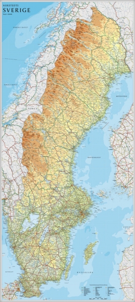
Een grote kaart van Zweden voor aan de muur. Decoratieve kleuren tonen verschillende hoogten en Zweedse bergketens. Belangrijke wegen, spoorwegen en steden zijn duidelijk herkenbaar.
Wordt geleverd op rol in stevige kartonnen koker.

Een grote kaart van Zweden voor aan de muur. Decoratieve kleuren tonen verschillende hoogten en Zweedse bergketens. Belangrijke wegen, spoorwegen en steden zijn duidelijk herkenbaar.
Wordt geleverd op rol in stevige kartonnen koker.

Duidelijke, heldere politieke kaart van Griekenland met houten ophanglatjes.
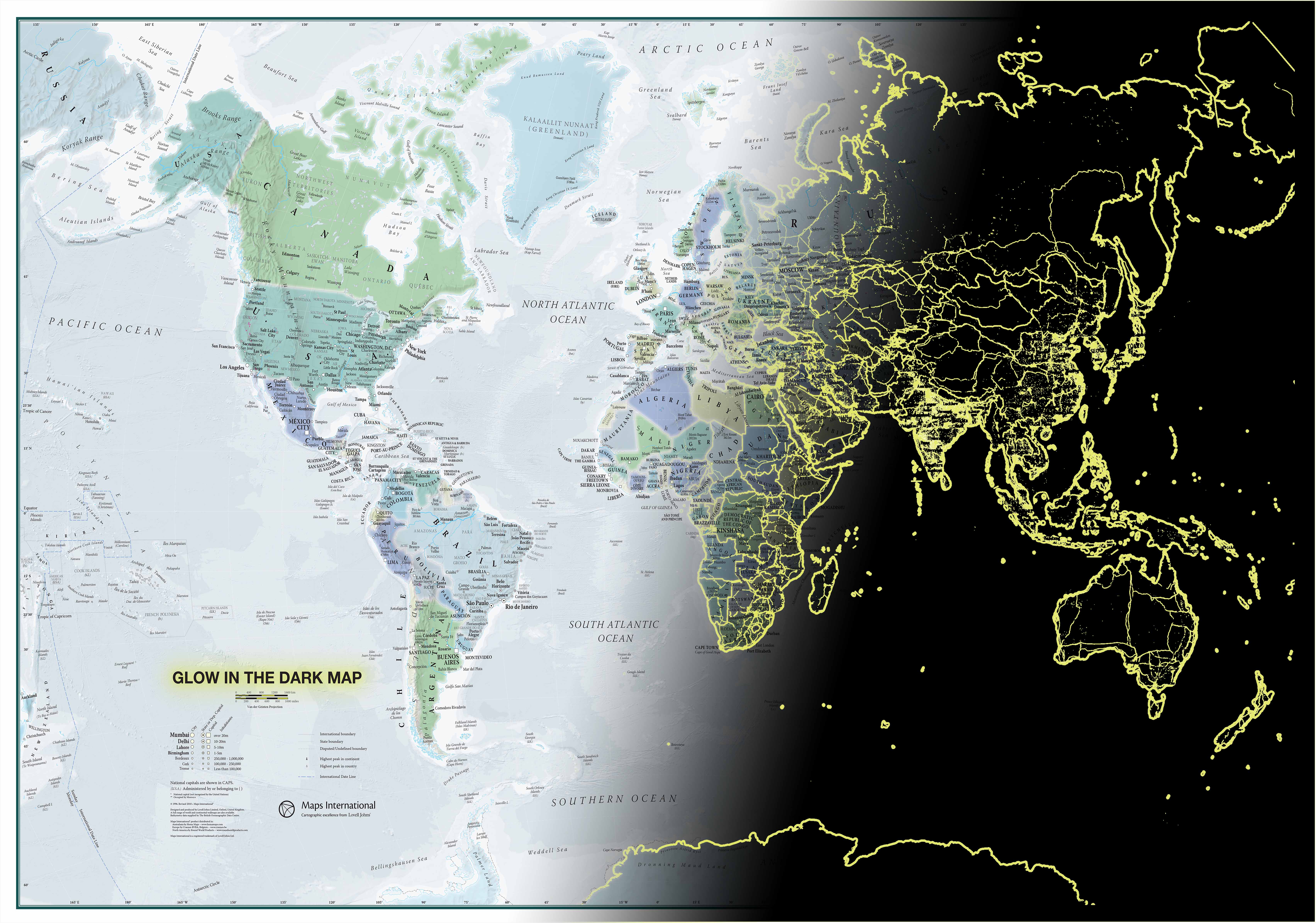
Als de nacht valt ziet men de wereldkaart tot leven komen als een verlichtte wereld.
Deze “Glow in the Dark” wereldkaart is perfect voor de kinderkamer: het is een leuk didactisch materiaal en het leidt hen, die mogelijk bang zijn in het donker, af.
Merk op dat de “Glow in the Dark” kaart oplaadt door het licht te absorberen dat de kamer binnenvalt. De oplichtende contouren komen ’s nachts magisch tevoorschijn en zijn enkel zichtbaar als de kamer donker is.
Afwerking: papier
Uw kaart wordt afgedrukt op papier van 110 g / m² en is niet afgewerkt.
As night falls see your Glow in the Dark World Map come to life as the world is illuminated.
Map Detail: Perfect for a child's bedroom, this Kids Glow in the Dark Map of the World is a fun educational tool as well as providing a welcome distraction for those that might be scared of the dark!
Maps Uses:Suitable for children or adults. Home decor, Childs Room, Learning.

De World Map is een prachtige wanddecoratie voor je woonkamer of kantoor. Met de afmeting van 103 x 180 cm geeft de World Map een specifieke uitstraling aan je interieur. Een geweldig idee voor een nieuwe woning, liefhebbers van reizen of een ieder die een persoonlijke touch wil geven aan de leefomgeving.
De World Map is eenvoudig aan te brengen door gebruik te maken van het meegeleverde transparante sticker vel. Hierdoor is geen lijm nodig, laat het geen rommel achter en heb je geen schilder nodig. De World Map is aan te brengen op de meeste vlakke ondergronden.
- Materiaal: hoge kwaliteit mat vinyl
- Afmetingen: 103 x 180 cm
- Verwijderbaar, maar niet herbruikbaar
- Verkrijgbaar in black, grey, red

Mooi, heldere wandkaart van Canada.
This Canada wall map clearly depicts all the cities, major roads and also shows all the Provinces and Territory boundaries. All major cities and areas are displayed bi-lingually.
This Canada Wall Map features:
• Provincial Boundaries
• Provincial Capitals
• Cities
• National and International Airports
• Latitude and Longitude Lines
• Physical Features and Terrain Shading
• Ocean Bathymetry
• Highways, Major Roads and Seasonal Roads
• Provincial Flags
• Provincial and National Parks
• Detailed Scale: 1:5,700,000

De kaart laat de geografische, etnografische (folklore, geschiedenis, cultuur), gastronomische, biologische (dieren, het leven in de zee, flora) en andere algemene wetenswaardigheden (betreffende sport, luchtvaart, schepen en vaartuigen) van de verschillende landen zien op een leuke en zeer interessante manier. Dit is een unieke geïllustreerde wandkaart, ongelooflijk aantrekkelijk voor kinderen vanwege de onweerstaanbare en kleurrijke tekeningen en afbeeldingen en het gebruik van mooie, heldere kleuren. De rijke, aanvullende informatieve tekst versterkt het leerrijke karakter van de kaart. Deze wereldkaart voor kinderen omvat meer dan 500 kwalitatief hoogwaardige illustraties. Deze leuke en leerzame kaart is geschikt voor alle leeftijden.
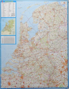
Wandkaart - Falk Nederland met een formaat van 130 (h) X 100 (b) cm. Het is een zeer gedetailleerde en duidelijke wandkaart, met veel plaatsen, wegen met wegnummers, afritten. Deze kaarten zijn echt gericht op plaatsen en wegen, natuurgebieden zijn minder duidelijk aangegeven.
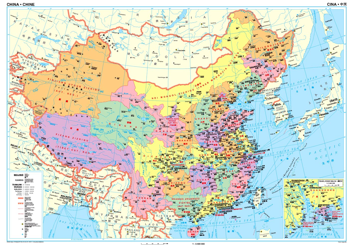
Een wandkaart van China waarop de politieke grenzen en steden tweetalig staan weergeven. Natuurkundige aspecten zijn weggelaten, maar dat komt de politieke en bestuurlijke indeling duidelijk ten goede.
Afmetingen: 69cm.x 95cm. (hxb)
An administrative wall map of China at 1:6,500,000, size 96 x 68cm (38" x 27" approx), from Gizi Map showing the division of the country into provinces. All place names are given in both Chinese and Latin alphabet. Hong Kong and the Pearl River Delta are presented in a greater detail on an inset.
China’s provinces are shown in bright contrasting colours. Town symbols indicate the size of the population. Main airports and ports are marked, as well as coastal and international shipping routes, Topographic information is limited to the network of rivers. Latitude and longitude lines are at 5° intervals. The map is not indexed. Multilingual map legend includes English. An inset shows Hong Kong and the Pearl River Delta region at 1:1,000,000.

DINO'S kaart van het zonnestelsel is een prachtig gelamineerd wandkaart voor kleine astronomen en astronauten die staan te popelen om meer kennis op te doen over de aarde en de wijdse ruimte die haar omgeeft.
De kaart geeft op een overzichtelijke en leerzame manier weer hoe het hele systeem van planeten staat en zich verplaatst in het heelal. Ze toont alle planeten met inbegrip van hun afmetingen en andere relevante informatie, alsmede de asteroïdengordel en kleine hemellichamen - meteoren, kometen en asteroïden. Er wordt uitgelegd wat lichtjaren zijn en zonsverduistering, en hoe de zon in elkaar zit. In
De geschiedenis van de ruimtevaart en de exploratie van het heelal evenals een aantal natuurverschijnselen die verband houden met de aarde en het zonnestelsel worden met kleurrijke illustraties weergegeven. De kaart beschikt ook over een geïllustreerde geschiedenis van het zonnestelsel, weergegeven als een stripverhaal. Een bijzondere attractie zijn de extra, onderwijzende maar plezierige illustraties die de weetgierigheid van de kinderen motiveren door middel van een spel van fictie en non-fictie.

National Geographic is a renowned authority in cartography. For 120 years the Society's maps have helped spread geographic knowledge around the globe. A vast database allows National Geographic to combine the latest data gained by space-age technology with innovative digital mapping techniques to create state-of-the-art political, physical, and thematic maps. The Society's meticulous research and attention to detail have established a standard of achievement that is unparalleled.
The rich tones of the Political Executive map combine the popular antique look with up-to-date information—elegant enough for the board room, study, or office, and contemporary enough to make it an ideal reference.

Deze kaart wordt gemaakt in drie delen - te groot om in 1 keer te fabriceren met kans op beschadigingen - die vervolgens zeer nauwkeurig aan elkaar worden geplakt. Daarna gaat er een coating overheen om de kaart geplastificeerd te maken. Een heel proces, maar het resultaat is prachtig!
National Geographic is a renowned authority in cartography. For 120 years the Society's maps have helped spread geographic knowledge around the globe. A vast database allows National Geographic to combine the latest data gained by space-age technology with innovative digital mapping techniques to create state-of-the-art political, physical, and thematic maps. The Society's meticulous research and attention to detail have established a standard of achievement that is unparalleled.
The rich tones of the Political Executive map combine the popular antique look with up-to-date information—elegant enough for the board room, study, or office, and contemporary enough to make it an ideal reference.

Wandkaart - Falk Nederland met een formaat van 130 (h) X 100 (b) cm. Het is een zeer gedetailleerde en duidelijke wandkaart, met veel plaatsen, wegen met wegnummers, afritten. Deze kaarten zijn echt gericht op plaatsen en wegen, natuurgebieden zijn minder duidelijk aangegeven.
Gelamineerd. Wordt geleverd op rol in plastic koker.

This colorful Europe political map clearly shows country boundaries, capitals, many major cities, bodies of water, airports, major highways and roads, and much more.

National Geographic is a renowned authority in cartography. For 120 years the Society's maps have helped spread geographic knowledge around the globe. A vast database allows National Geographic to combine the latest data gained by space-age technology with innovative digital mapping techniques to create state-of-the-art political, physical, and thematic maps. The Society's meticulous research and attention to detail have established a standard of achievement that is unparalleled.
The rich tones of the Political Executive map combine the popular antique look with up-to-date information—elegant enough for the board room, study, or office, and contemporary enough to make it an ideal reference.

Complete political actual detail of Germany - country boundaries, roads and cities, airports, bodies of water, and other geographic details in antique style.

Een schitterende en kleurrijke aquarel van de skyline van Londen. Een aanwinst voor elke muur.
A bright and colourful watercolour skyline of the city of London. With bold, dynamic and exciting watercolours, the skyline of London is brought to life, adding a contemporary splash of colour to any wall where this artwork is placed.
Printed on Silk Art Paper, a superior colour reproduction finish and provides high photo quality results.
200gsm silk: Coated in smooth silk material, combining strength and durability.

This colorful Europe political map clearly shows country boundaries, capitals, many major cities, bodies of water, airports, major highways and roads, and much more.

Completely redesigned and updated, National Geographic Maps' Caribbean Classic wall map is one of the most authoritative maps for the islands of the Caribbean Sea. This new edition shows the entire region in exceptional detail, with coverage extending from the tip of Florida to the northern extents of Colombia and Venezuela, east to Barbados, and west to the eastern edge of Honduras, Costa Rica, and Nicaragua. Updated bathymetry reveals the remarkable seafloor variation of the Caribbean including the Puerto Rico Trench, the deepest point in the Atlantic Ocean at 8,605 meters (28,232 feet).
Caribbean Classic is a perfect tool for business or education reference, and a beautiful addition to any décor. Shown on the map are over 1,000 named places including country capitals, primary and secondary towns; political boundaries, important infrastructure, and all key landforms. Useful and informative notes about the region's history and unique geography are spread throughout the map, providing the reader further understanding of the Caribbean's unique attributes. This classic-style wall map contains National Geographic's world-recognized proprietary fonts, and bright easy-to-read colors.

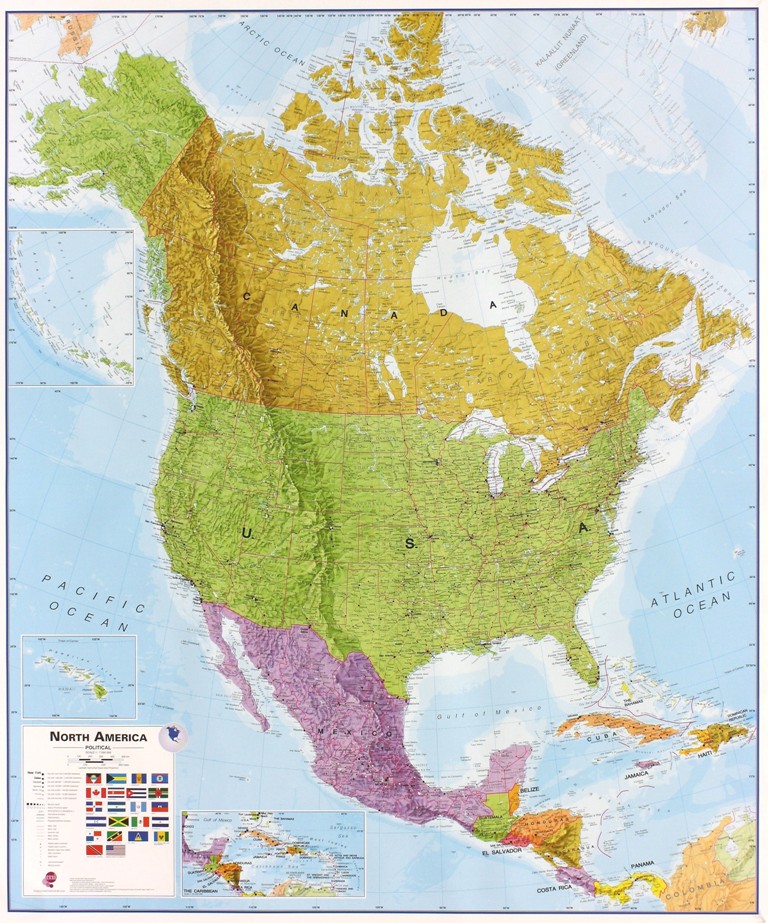
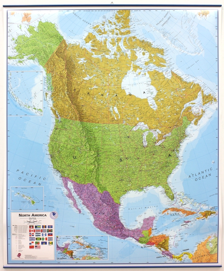
The political map of North America features trademark National Geographic detail and accuracy. The map shows country boundaries, place names, major highways and roads, bodies of water, and more. An inset map shows the Aleutian Islands off the coast of Alaska.
Our classic wall map of Russia and the independent states of the former Soviet Union shows thousands of place names, roadways, political boundaries, bodies of water, airports, and many other geographic details.
Map is printed on premium quality paper stock, rolled, and packaged in a clear, hard plastic tube.
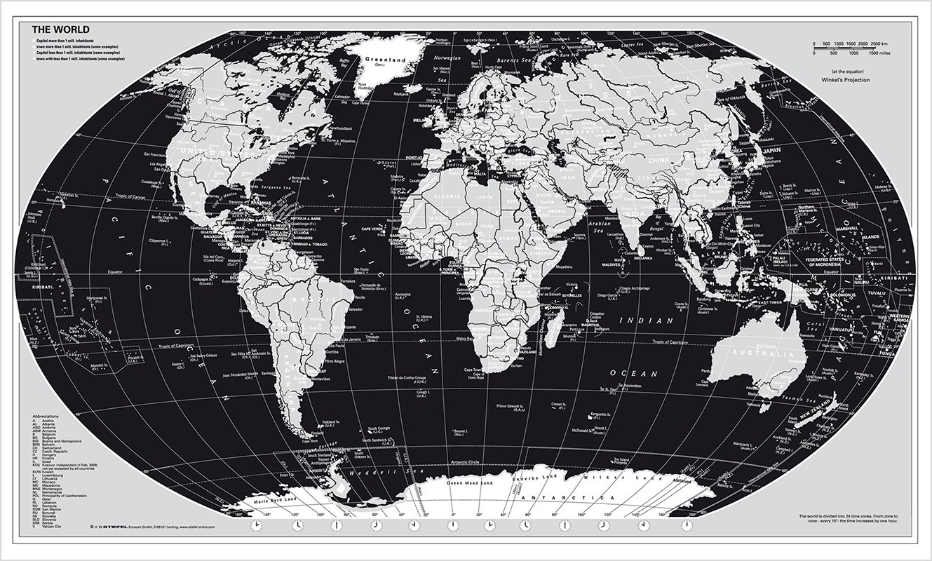
Mooie wereldkaart met zwarte oceanen en zilverkleurige continenten.

Duidelijke, heldere kaart van Afrika. Geplastificeerd met metalen ophangstrips.Beschrijfbaar en afwisbaar.
Wandkarte mit Metallbeleistung
- beschreib- und abwischbar
- extrem reißfest-
- Ländergrenzen
- alle wichtigen Städte und Hauptstädte
- Postleitzahlenbereiche (soweit vorhanden)
- Hauptverkehrsnetz, internationale Flughäfen, wichtige Häfen und Bahnlinien
- Landschaftsnamen
- Gebirge
- Höhen- und Gebirgszüge als Relief dargestellt
- Beschriftung in englischer Sprache
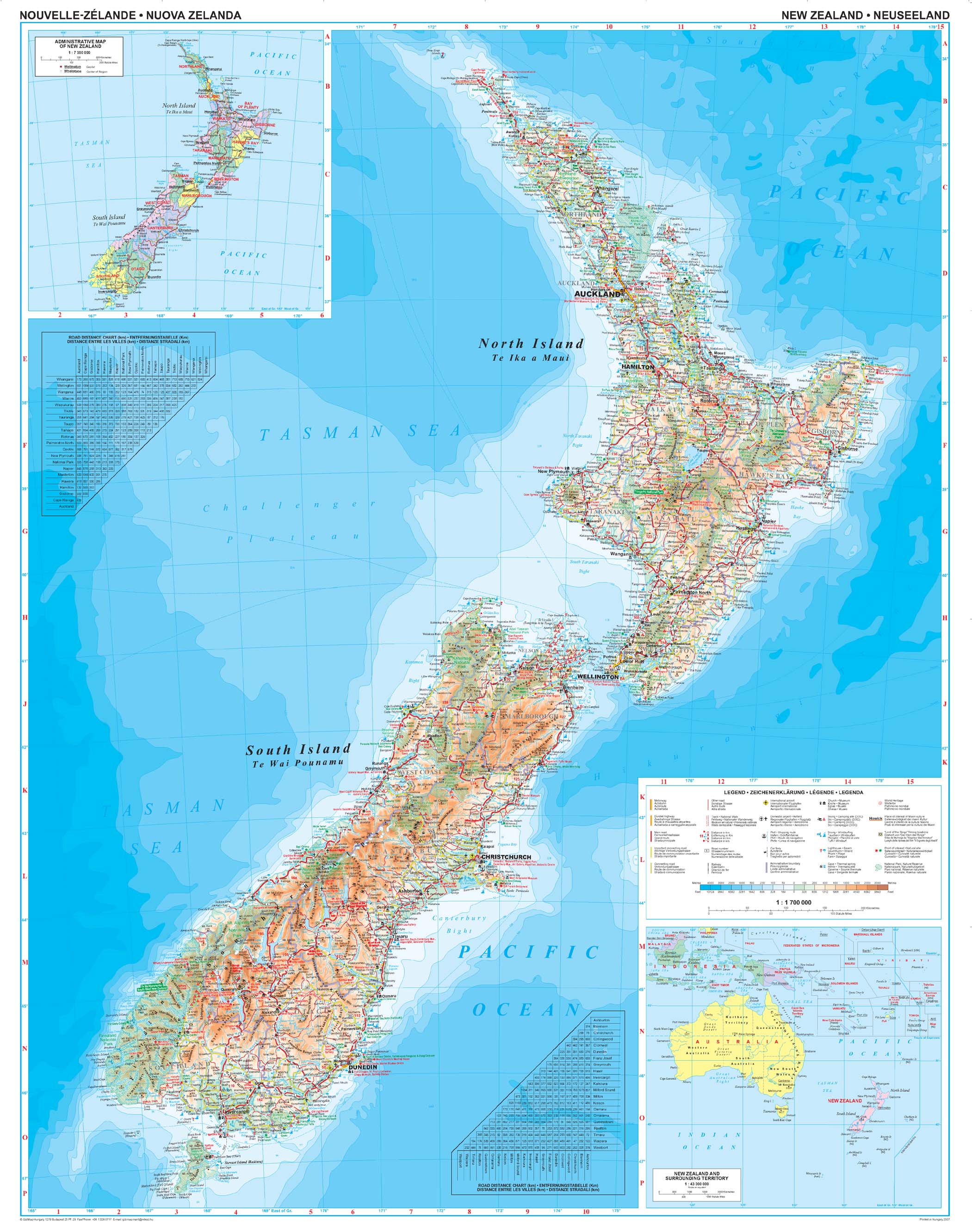
Mooie geografische kaart van Nieuw Zeeland.

The political map of North America features trademark National Geographic detail and accuracy. The map shows country boundaries, place names, major highways and roads, bodies of water, and more. An inset map shows the Aleutian Islands off the coast of Alaska.

This richly colored map of North America - featuring country boundaries, place names, major highways and roads, and bodies of water - is excellent for reference in your home or office. An inset map shows the Aleutian Islands off the coast of Alaska.

This classic map of South America shows political boundaries, place names, airports, major roads and highways, and other geographic features for the entire continent.

This elegant, richly colored map of South America shows political boundaries, place names, airports, major roads and highways, and other geographic features for the entire continent.

This elegant, richly colored map of South America shows political boundaries, place names, airports, major roads and highways, and other geographic features for the entire continent.

This classic-style map of Spain and Portugal shows political boundaries, major highways and roads, cities and towns, airports and other geographic details. Thousands of place-names and exact borders are carefully researched by National Geographic s map researchers and editors ensuring the utmost accuracy.

Staatkundige kaart van Zuid-Amerika (in kleur). De kaart wordt verzonden in een koker.
This classic map of South America shows political boundaries, place names, airports, major roads and highways, and other geographic features for the entire continent. 36 x 46 inches (approx). Scale size: 1:7,105,000.
Founded in 1915 as the Cartographic Group, the first division of the National Geographic Society, National Geographic Maps has been responsible for illustrating the world around us through the art and science of mapmaking.
Today, National Geographic Maps continues this mission by creating the world s best wall maps, recreation maps, atlases, and globes which inspire people to care about and explore their world. All proceeds from the sale of National Geographic maps go to support the Society s non-profit mission to increase global understanding and promote conservation of our planet through exploration, research, and education.
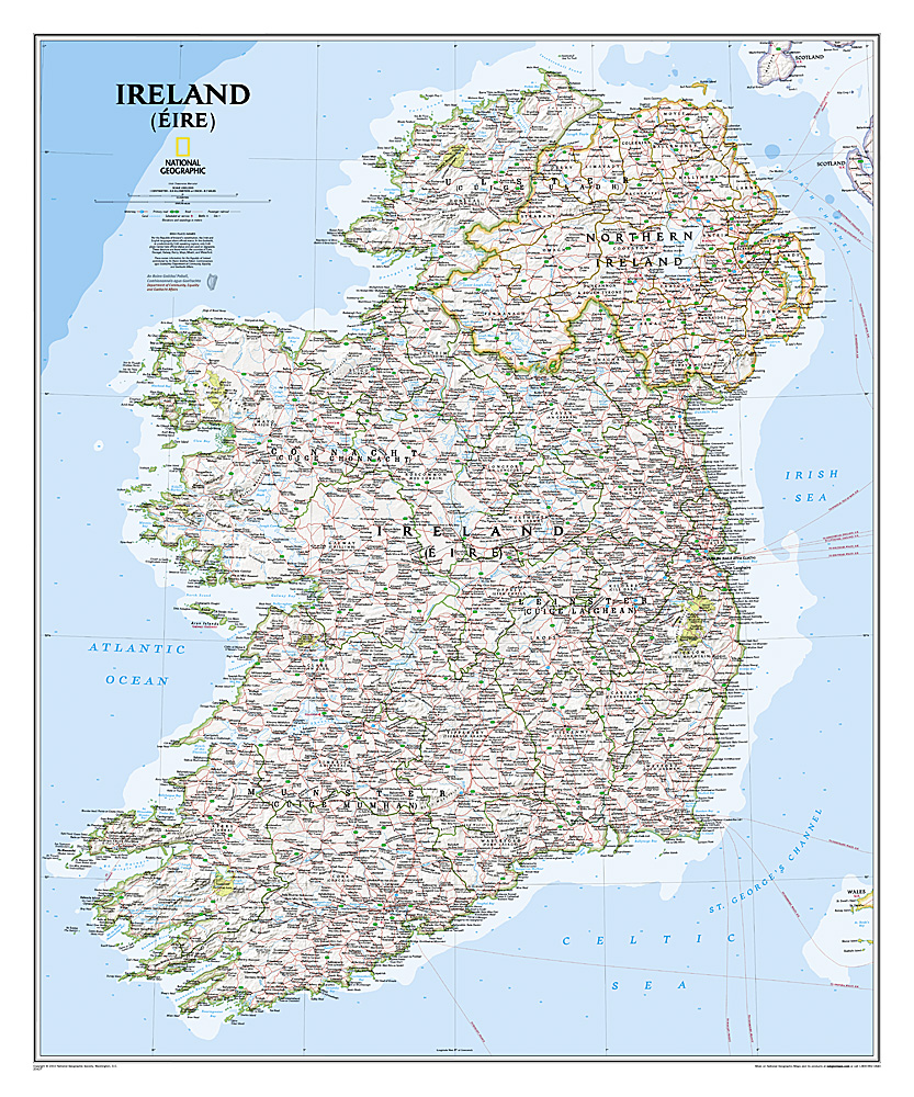
National Geographic Maps' new Ireland wall map is one of the most authoritative maps yet published of the Emerald Isle. Of the nearly 1,000 place-names shown on this map, all within the Republic of Ireland adhere to that nation's constitution—that the Irish and English language share official status. Thus, Gaelic (Irish) place-names, along with their English variants in parentheses, are shown within Irish-speaking regions while English place-names, along with their Gaelic variants, are shown outside these areas.
Ireland Classic is ideal for those researching their Irish ancestry, a perfect tool for business reference, and a beautiful addition to any décor. It’s one of the largest and most detailed wall maps specifically for Ireland available today. Shown on the map are over 1,000 named places including primary and secondary towns, counties, political boundaries, infrastructure, and selected historical sites for both Ireland and Northern Ireland.
Place-name Details:
Per the Republic of Ireland’s constitution, the Irish and English languages share official status. In the Gaeltacht, or predominantly Irish-speaking regions, only Irish place-names have official status and are used on signposts. These districts are found within the counties of Cork, Donegal, Galway, Kerry, Mayo, Meath, and Waterford.
Place-names information for the Republic of Ireland contributed by An Roinn Gnotai Pobail, Comhionannais agus Gaeltachta/ Department of Community, Equality and Gaeltacht Affairs.
National Geographic Wall Maps offer a special glimpse into current and historical events, and they inform about the world and environment. Offered in a variety of styles and formats, these maps are excellent reference tools and a perfect addition to any home, business or school. There are a variety of map options to choose from, including the world, continents, countries and regions, the United States, history, nature and space.
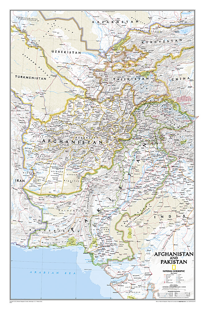
This is the latest and most detailed map of the region - a perfect complement for following today's news stories. Afghanistan's 34 administrative provinces and Pakistan's provinces and territorial boundaries are clearly delineated. The region's diverse terrain is expertly depicted in shaded relief and symbology, including the elevation of prominent mountains and ocean depths in meters. Superhighways, major roads, canals, railroads, oil infrastructure, and geologic features are detailed.
National Geographic Wall Maps offer a special glimpse into current and historical events, and they inform about the world and environment. Offered in a variety of styles and formats, these maps are excellent reference tools and a perfect addition to any home, business or school. There are a variety of map options to choose from, including the world, continents, countries and regions, the United States, history, nature and space.
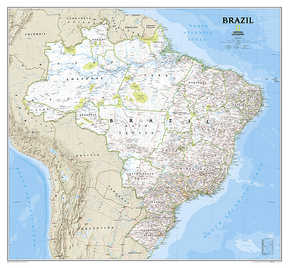
This wall map of Brazil contains thousands of place names and accurate political boundaries including Brazil's 26 states. Major and minor cities, superhighways, roads, passenger rail lines, and national parks are clearly depicted. Brazil's diverse terrain is represented through accurate shaded relief and hydrographic symbology. Elevations and depths are in meters.

Politieke wandkaart in bijzondere kleurstelling. De indeling van de kaart is natuurlijk wel up-to-date. De kaart is 136 x 84 cm groot en in het Engels. Alle landen staan er op met voor de USA, Brazilië, Canada en Australië ook nog een provincies. Schaduw in reliëf zorgt voor aanduiding van de belangrijkste berggebieden met namen en hoogte van bepaalde toppen. Met symbolen wordt de grootte van een stad aangeduid, met ook een overzicht van de belangrijkste wegverbindingen. Kleurgebruik zorgt voor een mooi beeld van de oceanen.
A popular world wall map within our premium map range! With its antique-style muted tones, it looks simply stunning and rather elegant.
Map details: Splendid premium wall map of the world in muted tones. This premium world wall maps is available mounted on a walnut style frame. Complete with political detail (countries shaded in different tones), country boundaries and cities shown, this really is the most stylish and practical map available!
Laminated: Your wall map will be finished with a gloss encapsulation process. Encapsulation means that the maps are heat sealed between two sheets of industrial quality film. Please note that the edges of this map are not sealed.
Encapsulation gives the map a write on wipe off finish, meaning that, using the appropriate pen (for whiteboard use) or Chinagraph pencil any writing on the map can be wiped off with a damp cloth.
Map uses: Perfect for adding an exclusive feel to a boardroom or office. This world map also adds a touch of luxury hung in the home, ideal for the more discerning customer.
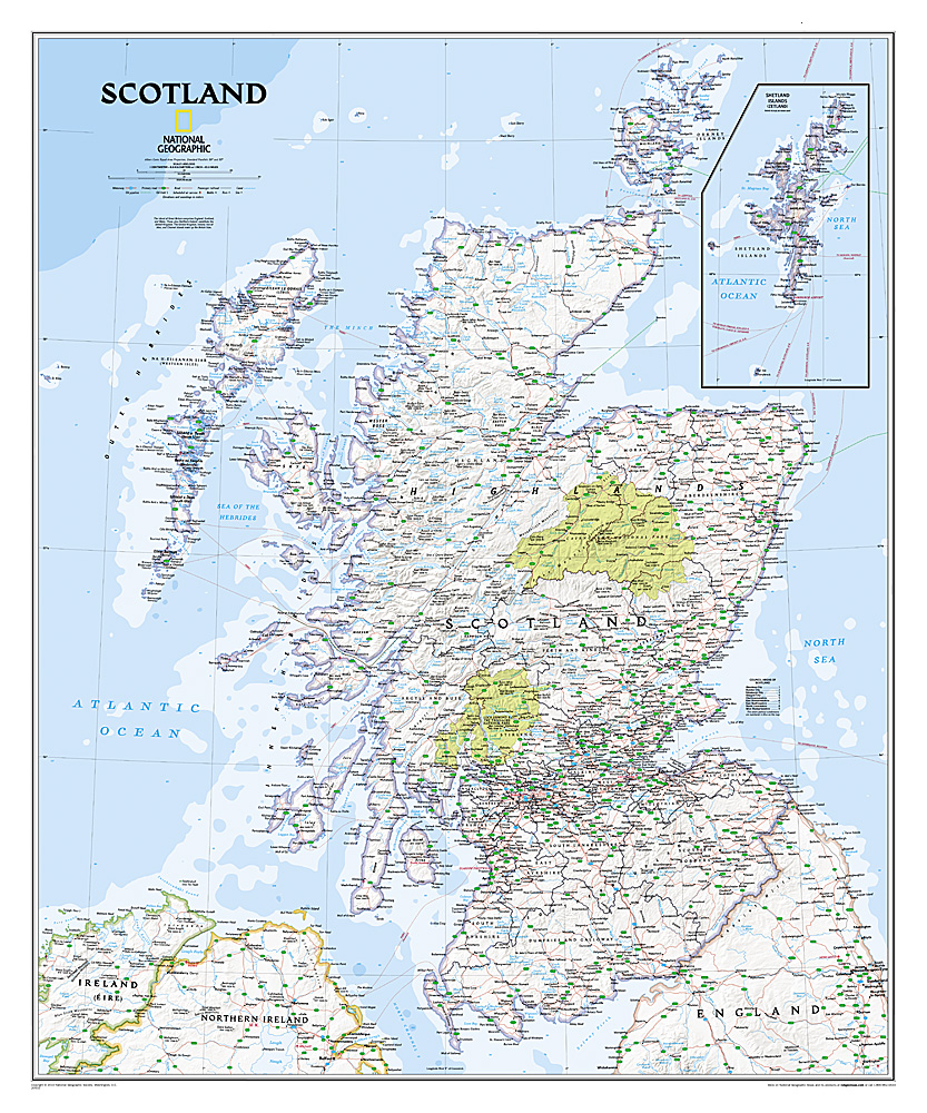
This new map of Scotland, features our rich, antique-inspired Executive style. This beautiful map includes thousands of place names, accurate political boundaries, national parks, archeological sites, and major infrastructure networks such as roads, canals, ferry routes, and railroads. Scotland’s diverse terrain is detailed through accurate shaded relief, coastal bathymetry, and symbolism for water features and other landforms.

Study the countries of the Balkans with our new map featuring the classic National Geographic reference styling. Features thousands of place names, accurate political boundaries, national parks, and major infrastructure networks such as roads, canals, ferry routes, and railroads. The countries of the Balkans Classic map shows it's diverse terrain as detailed through accurate shaded relief, coastal bathymetry, and symbolism for water features and other landforms. Elevations of major peaks as well as depth soundings are expressed in meters.
Map coverage includes the countries of: Albania, Austria, Bosnia and Herzegovina, Bulgaria, Croatia, Hungary, Kosovo, Macedonia, Moldova, Montenegro, Romania, Slovenia, Vojvodina, as well as the outlying border countries of Greece, Italy, Slovakia, Turkey and Ukraine. Map features also includes listings for the counties of Hungary and Romania along with their respective capitals and the administrative divisions of Bosnia and Herzegovina.
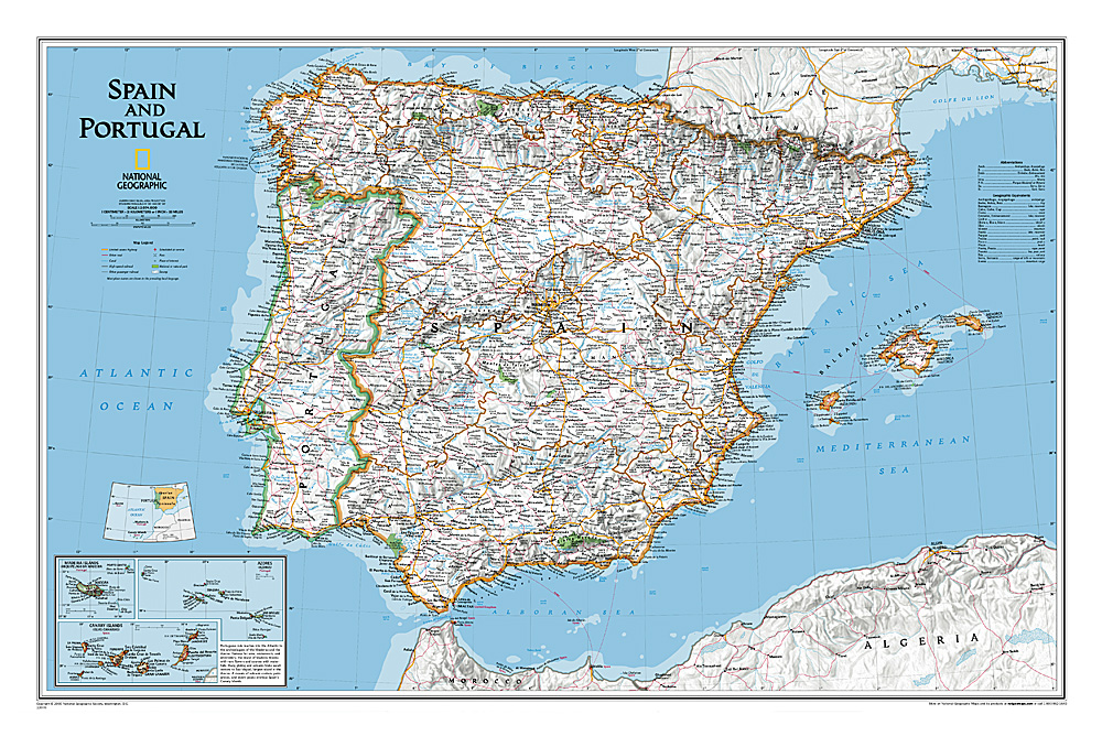
This classic-style map of Spain and Portugal shows political boundaries, major highways and roads, cities and towns, airports and other geographic details. Thousands of place-names and exact borders are carefully researched by National Geographic s map researchers and editors ensuring the utmost accuracy.
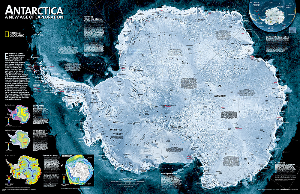
This digital mosaic of 4,500 satellite scans shows incredible detail of Antarctica's terrain. Includes insets that show the surface elevation, ice sheet thickness, ice flow velocity, and sea ice movement and wind flow.

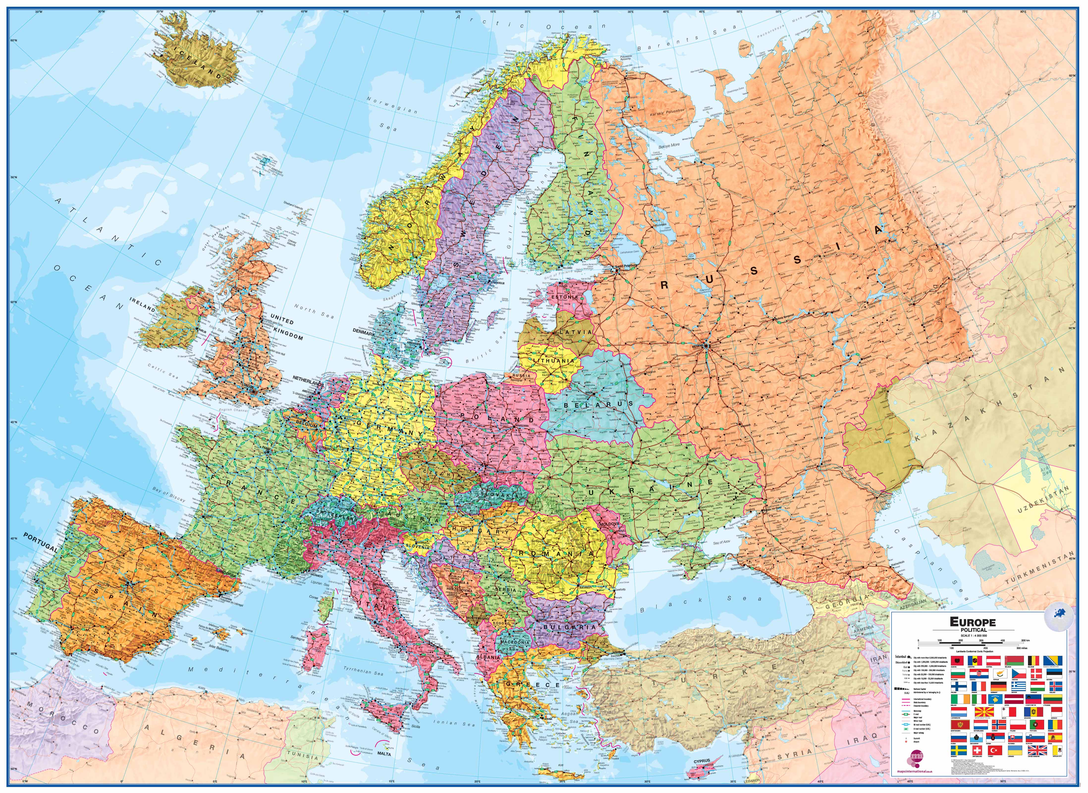
De Michelin kaart van Europa met meer dan 40 Europese landen is actueel, gedetailleerd, nauwkeurig, praktisch en internationaal. Landgrenzen zijn goed leesbaar. De grote wegen staan met afstanden en wegnummer vermeld.
Educational and decorative, this Europe political wall map is ideal for use in both home and office. Updated annually and beautifully coloured, this map highlights flags of each European country and includes information on population, surface area and density. This map also shows main European road networks, cities and capitals. This map is presented on a scale 1/4,300,000 and measures 100 x 122 cm.
MICHELIN Europe political wall map features:
* Flags for each European countries
* Stastical information: population, surface area, density
* Main road networks
* Main cities of Europe and capitals

Maps International's large physical wall map of Europe is one of the finest money can buy.
European Map details: Our large physical wall map of Europe features the natural terrain of the land, with countries marked and international borders shown. The map's key helps to identify the land elevation and water depth. This large European physical wall map also contains city population detail, national capitals and all the major towns and cities in Europe.
Map uses: As with most of our maps, the large physical wall map of Europe, is available in a range of finishes making it suitable for a variety of locations. Major motorways and transport lines are shown on this European wall map making it an ideal map for planning and logistics

Politieke wandkaart in ouderwetse kleurstelling. De indeling van de kaart is natuurlijk wel up-to-date. De kaart is 136 x 84 cm groot en in het Engels. Alle landen staan er op met voor de USA, Brazilië, Canada en Australië ook nog een provincies. Schaduw in reliëf zorgt voor aanduiding van de belangrijkste berggebieden met namen en hoogte van bepaalde toppen. Met symbolen wordt de grootte van een stad aangeduid, met ook een overzicht van de belangrijkste wegverbindingen. Kleurgebruik zorgt voor een mooi beeld van de oceanen. 3
Political wall map of the world from Maps International, size 136 x 84cm, in an antique-style presentation: countries in hues of brown, beige and tan with their borders outlined in a stronger colour - oceans in light grey, with graphic relief for the ocean floor and names in italics adding to the overall elegant, old-fashioned feel.

De uitgever van de kaart is de bekende Duitse uitgever GeoRelief GbR. Deze topografische kaart van Europa heeft een hoge kwaliteit met prachtige kleuren (engelse versie). De kaart bevat de namen van grote steden, spoorwegen, wegennet, de namen van bergketens en internationale luchthavens. Gemaakt van een hoge kwaliteit kunststof. Extreem duurzaam.
Van de uitgever
Our relief map of Europe in the scales 1:8,000,000 or 1:16,000,000 is an impressive, visually attractive and naturally knowledge-imparting enrichment for classrooms or living rooms. From your office, create a geographical reference to current political developments or major social events. Use the card to actively plan your spring awakening excursion to Italy or Mallorca, your annual holiday in Scandinavia, a city trip to Paris or Saint Petersburg or a business trip to London, Frankfurt or Istanbul. Once there, you can also send the “old continent” in postcard format by post to friends, relatives, and other interested parties.

Politieke wandkaart in ouderwetse kleurstelling. De indeling van de kaart is natuurlijk wel up-to-date. De kaart is 136 x 84 cm groot en in het Engels. Alle landen staan er op met voor de USA, Brazilië, Canada en Australië ook nog een provincies. Schaduw in reliëf zorgt voor aanduiding van de belangrijkste berggebieden met namen en hoogte van bepaalde toppen. Met symbolen wordt de grootte van een stad aangeduid, met ook een overzicht van de belangrijkste wegverbindingen. Kleurgebruik zorgt voor een mooi beeld van de oceanen.
Political wall map of the world from Maps International, size 136 x 84cm, in an antique-style presentation: countries in hues of brown, beige and tan with their borders outlined in a stronger colour - oceans in light grey, with graphic relief for the ocean floor and names in italics adding to the overall elegant, old-fashioned feel.
Fraaie politieke kaart van het continent, waarbij vooral de politieke aspecten heel duidelijk te lezen zijn. Alle landen hebben verschillende kleuren, steden en belangrijke verbindingen zijn goed te vinden. Dit is geplastificeerde uitvoering zonder ophangsysteem.
Maps International's North America political wall map covers a huge expanse of land from Alaska and Canada through the United States down to Mexico, Central America and the Caribbean. One of the finest maps money can buy!
This political wall map of North America features countries shown in different colours, international boundaries and major transport networks. The wall map also contains a panel of flags relating to the countries shown in this North American continent map. Also shown is city population detail, capital cities and all the major towns and cities in this continent of North America.
Maps International's North America map is available either plain or laminated. Ideal for an office, classroom or when planning a trip to this American continent.

Prachtige wandkaart van China, waarbij zowel de politieke natuurkundige aspecten goed zichtbaar zijn. In rood zijn de belangrijkste toeristische hoogtepunten ingetekend. Kleurgebruik is vrij fel, maar daardoor wordt het geheel bijzonder mooi. De afmetingen zijn 120 x 88 cm.
Hooggebergte, woestijnen, laagland en aanduidingen van hoogte vind je op de kaart. Ook een grote hoeveelheid plaatsen en de belangrijkste verbindingsroutes zijn ingetekend.

DINO'S Geïllustreerde Kaart van de wereld van de Dieren is een aantrekkelijke en kleurrijke presentatie van de dieren, verspreid over de hele wereld, in hun natuurlijke geografische en biologische omgeving. Voorgesteld met eenvoudige symbolen wordt wetenswaardige basisinformatie, zoals afmetingen, gewicht, voeding en andere gewoonten voor elke individuele diersoort weergegeven. Dit maakt deze kaart uiterst interessant en leerzaam voor iedereen die geïnteresseerd is in de diverse en uitgebreide dierenwereld. Als speciale toevoeging toont de kaart ook een "levensboom van de dierenwereld" die de verdeling van de dieren in taxonomische groepen illustreert.
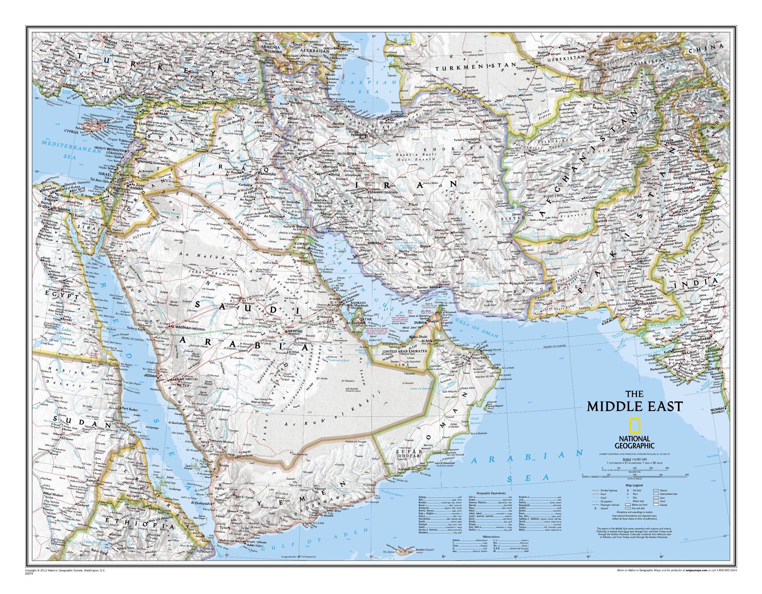
Wandkaart van het Midden Oosten, met o.a. Afghanistan - Pakistan - National Geographic wandkaart geplastificeerd - Afmeting ca 76 x 58 cm
National Geographic Maps' recently updated wall map of the Middle East region, formerly titled Afghanistan/Pakistan and the Middle East.
Includes updated place names and the addition of significant locations currently in the news, such as Marjah, Afghanistan. This wall map covers a broad geographic area ranging from northern Africa through the Middle East to the western edge of China and India.
Includes complete coverage of Afghanistan, Pakistan, Tajikistan, Iran, Iraq, Kuwait, Syria, Israel, Jordan, Lebanon, Saudi Arabia, Qatar, Bahrain, United Arab Emirates, Yemen, Oman, Cyprus, and Eritrea.
Also includes parts of India, China, Kyrgyzstan, Uzbekistan, Turkmenistan, Azerbaijan, Armenia, Turkey, Egypt, Sudan, Ethiopia, and Djibouti. Features thousands of place names, accurate political boundaries, archeological sites, and major infrastructure networks such as roads, canals, ferry routes, airports, and railroads. The region's diverse terrain is detailed through accurate shaded relief, coastal bathymetry, and symbolism for water features and other land forms. Elevations of major peaks and depth soundings are expressed in meters.
The Middle East Wall Map is printed on high-quality 80# paper suitable for framing, and is also available in a laminated edition. Additional, more detailed, wall maps are available for many of the countries featured on this map.

Decoratieve wandkaart van Canada. Naast de mooie kleuren staan er bijzonder veel plaatsen op vermeld.
This beautiful wall-map from National Geographic depicts Canada and the areas surrounding the Great Lakes in beautiful and accurate detail. Included in the map are Canadian province and US State boundaries, cities and towns, lakes and waterways, major geographic features, roadways, and other geographic details.
Our most detailed wall map of Canada, features the classic National Geographic reference styling. Features thousands of place names, accurate political boundaries, national parks, archeological sites, and major infrastructure networks such as roads, canals, ferry routes, and railroads. Canada s diverse terrain is detailed through accurate shaded relief, coastal bathymetry, and symbolism for water features and other landforms. This wall map depicts Canada and the areas surrounding the Great Lakes. Includes Canadian provinces and US State boundaries.
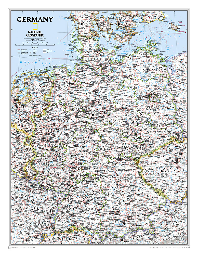
Decoratieve wandkaart van Duitsland. Naast de mooie kleuren staan er bijzonder veel plaatsen op vermeld.
National Geographic's political map of Germany includes everything from country boundaries, major roads, towns and cities, airports, bodies of water, and other geographic details. It's a great addition to any classroom, office, or home.
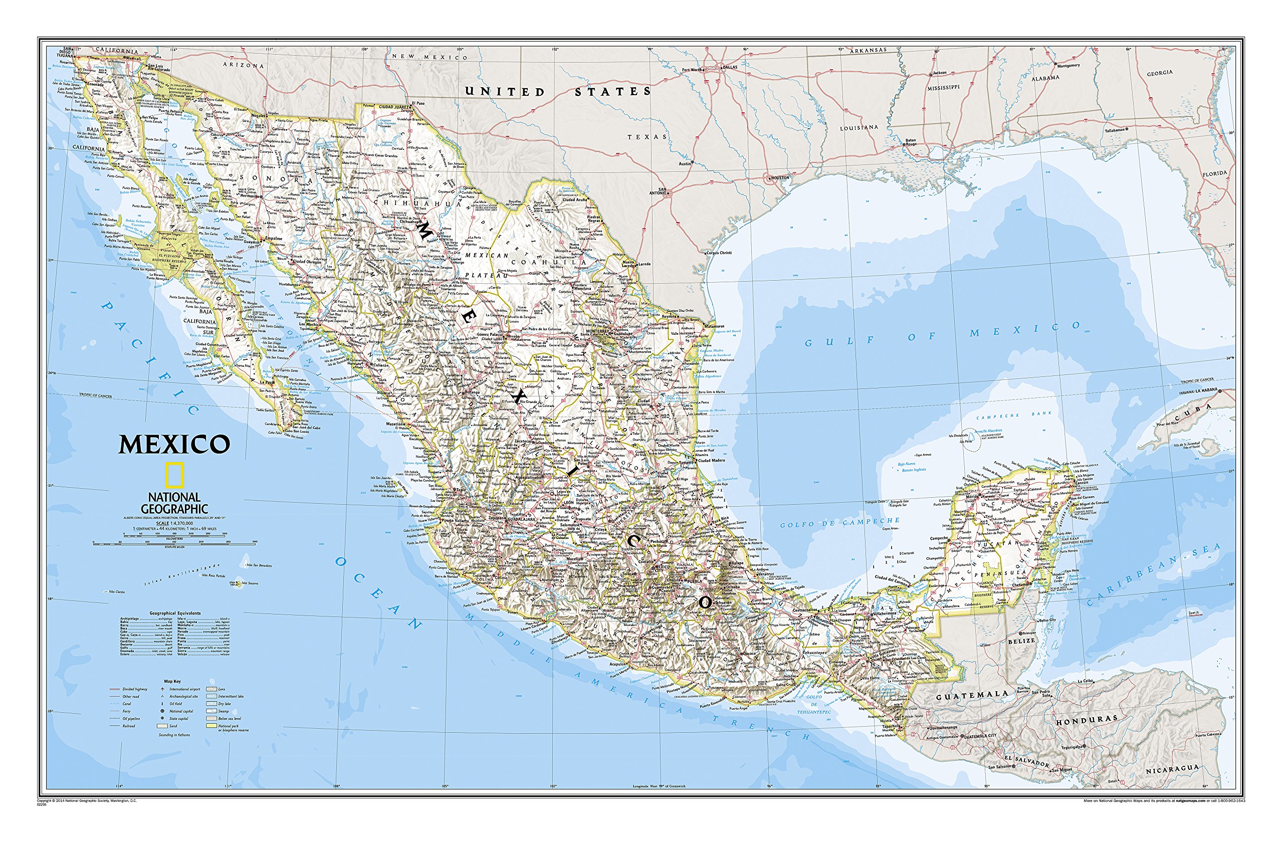
Decoratieve wandkaart van Mexico. Naast de mooie kleuren staan er bijzonder veel plaatsen op vermeld.
This finely detailed National Geographic political map of Mexico shows country boundaries, cities and towns, airports, major highways and roads, and bodies of water. Shaded relief helps to show the country's terrain more clearly and accurately.
Features:
•Shaded relief
•Accurate political markings
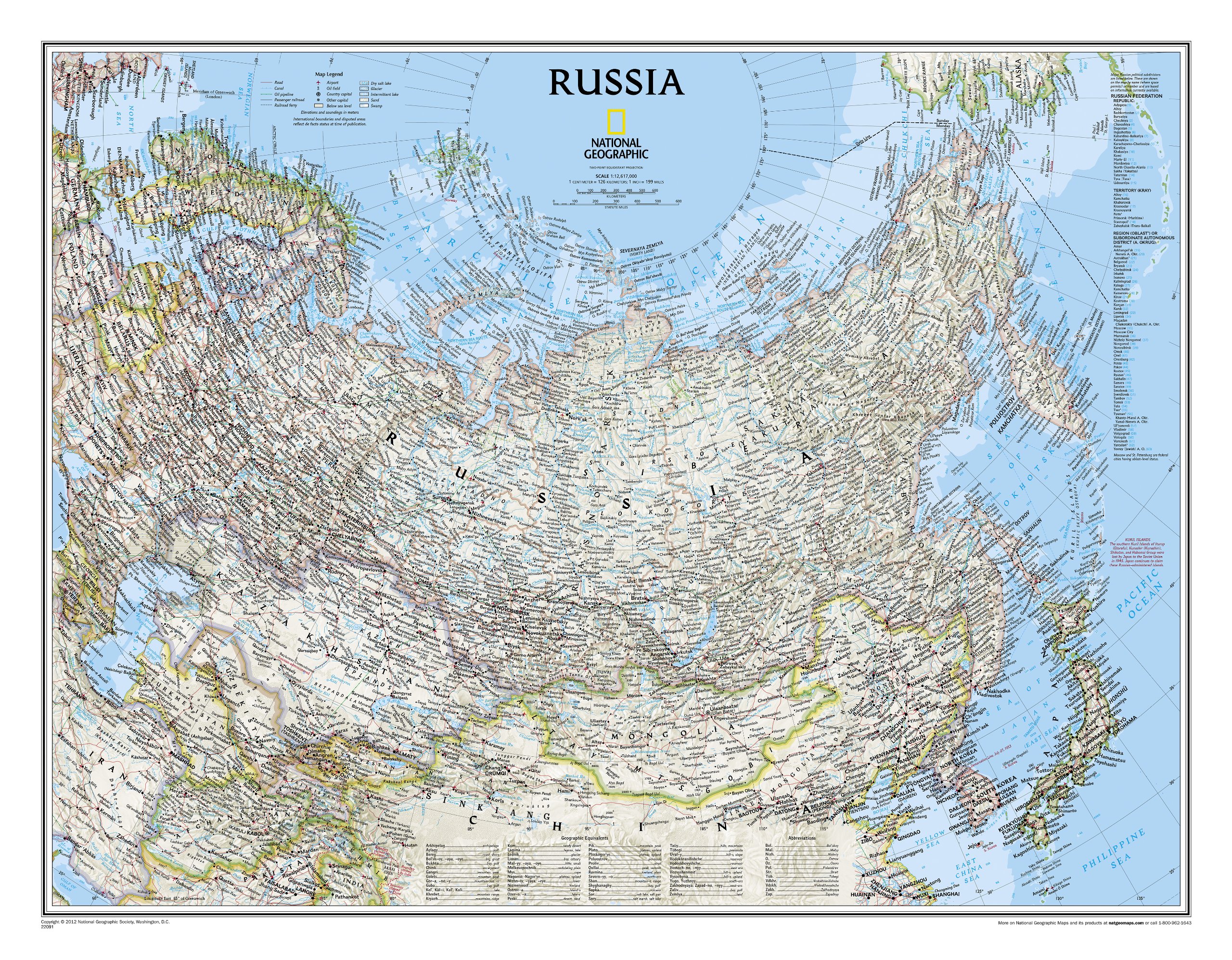
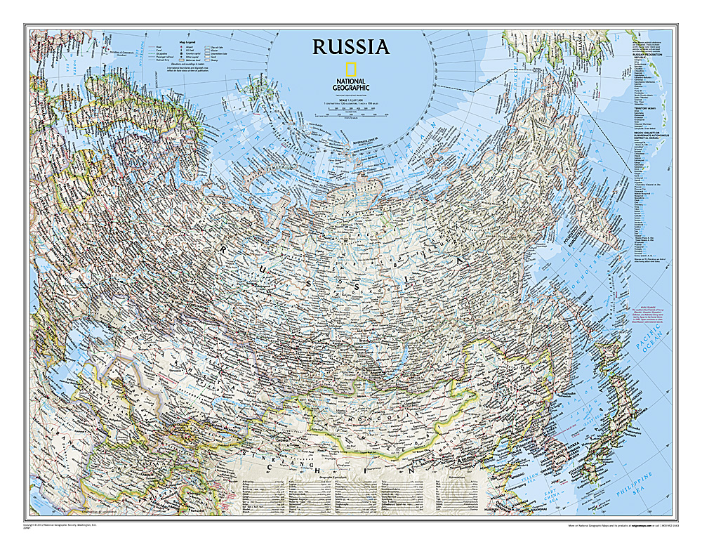
Decoratieve wandkaart van het land. Naast de mooie kleuren staan er bijzonder veel plaatsen op vermeld.
National Geographic's classic wall map of Russia and the independent states of the former Soviet Union shows thousands of place names, roadways, political boundaries, bodies of water, airports, and many other geographic details.
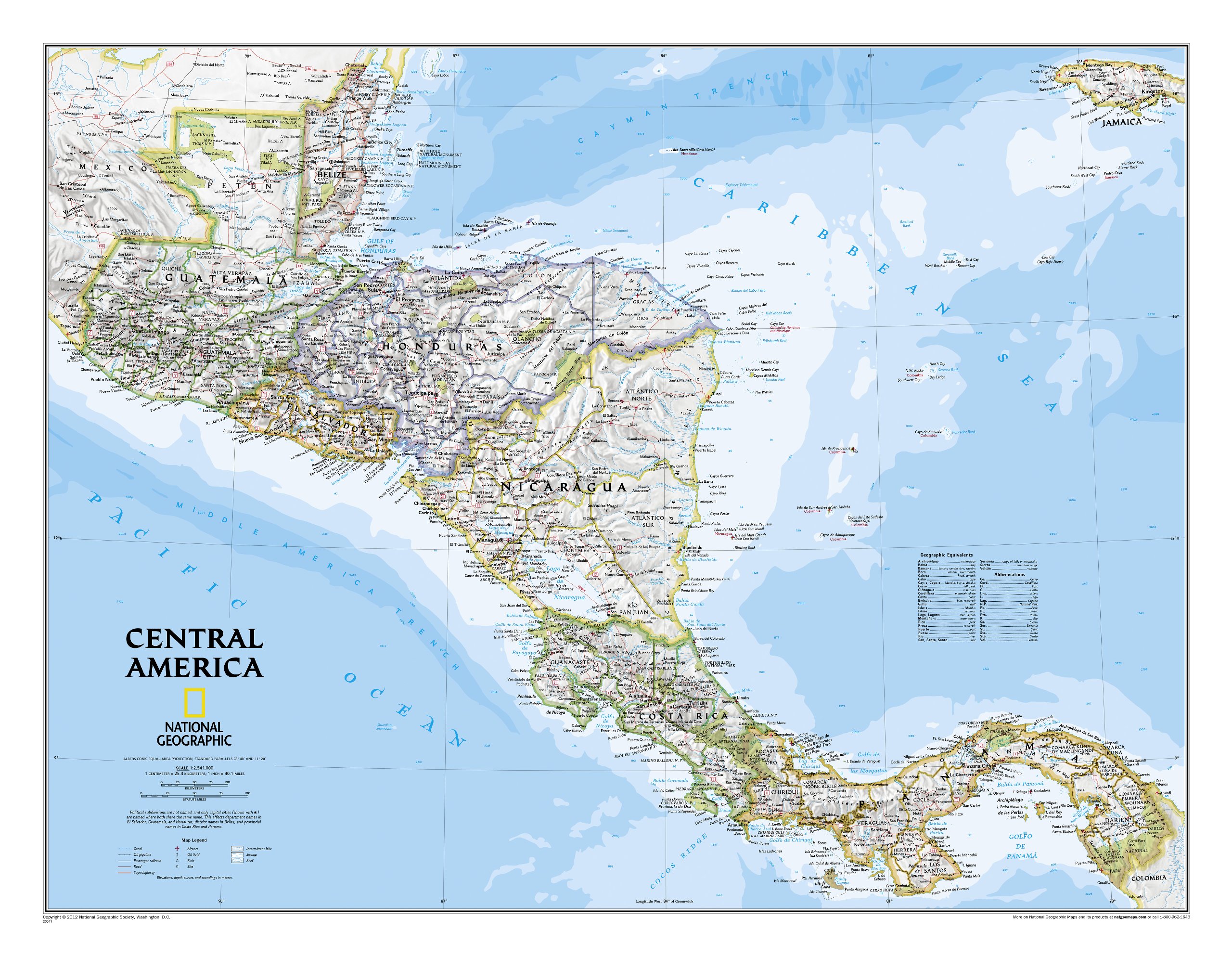
This Central America Wall Map by National Geographic contains extensive political information with political boundaries clearly presented with different color-bands for each country. Beautifully shaded to show physical terrain, this map is both a useful reference tool and a quality piece of art, perfect for any home, office or classroom.
Details featured on this wall map of Central America include:
• Political Boundaries
• Major Cities and Capitals
• Physical Terrain Shading
• Mountain Ranges, Highest Point
• Lakes, Seas, Rivers and Waterways
• Sand, Swamp, Salt Desert, Dry Salt Lake or Coral Reef
• Latitude and Longitude Lines
• Basic Bathymetry (Ocean Depths)
• Major Airports
• National Parks
• Major Roads and Highways
• Oil Fields, Railroads, and Ruins
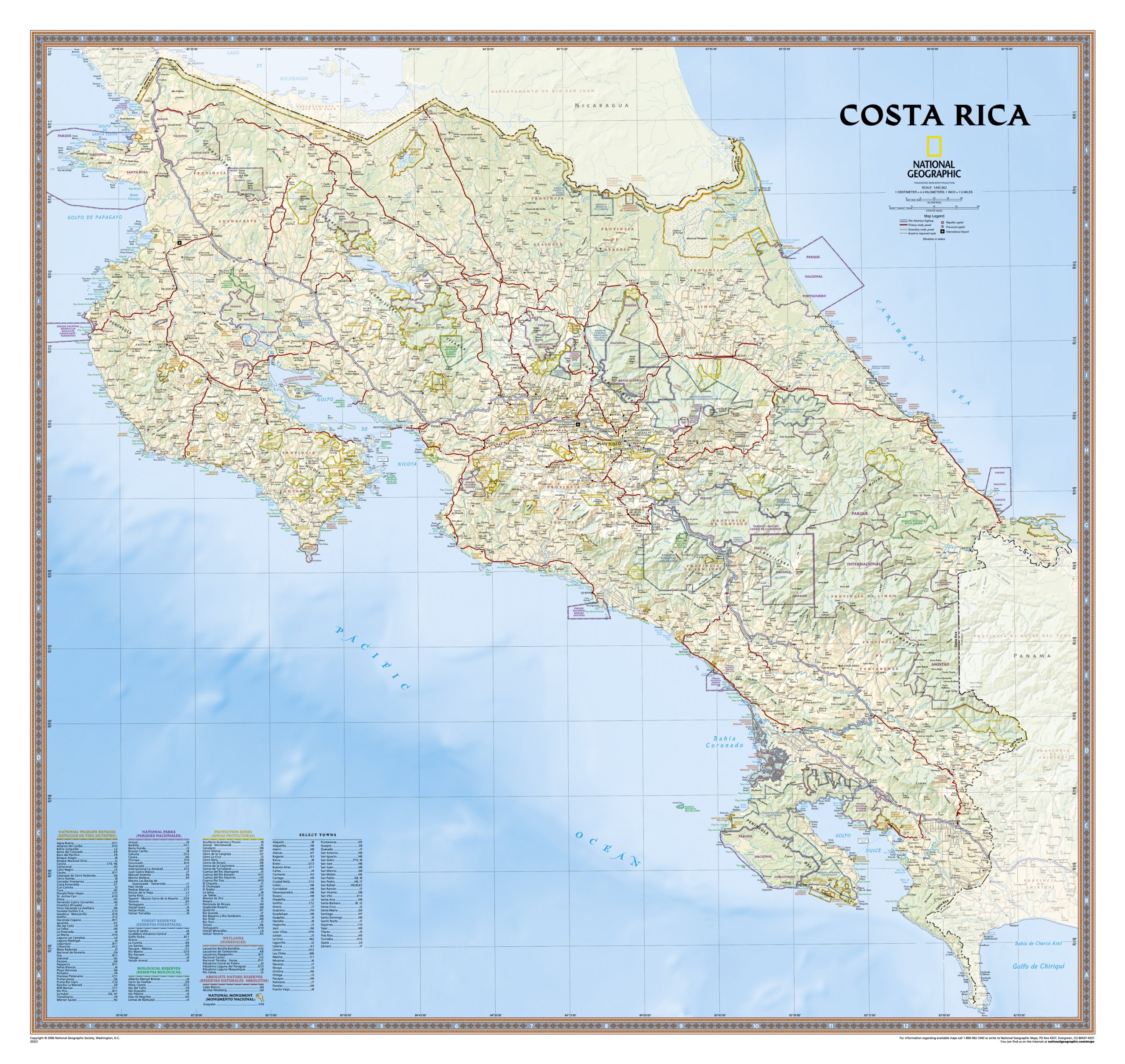
Decoratieve wandkaart van Costa Rica. Naast de mooie kleuren staan er bijzonder veel plaatsen op vermeld.
This full-color map is a richly detailed rendering of one of Central America's greatest treasures. From its northern savannahs and plains to lush forests and pristine jungle-lined beaches, Costa Rica's beauty and diversity beckon! The map also includes outlines and information for National Parks, Protection Zones, and more.
This version is laminated—featuring a "write and wipe" surface and durable plastic covering.
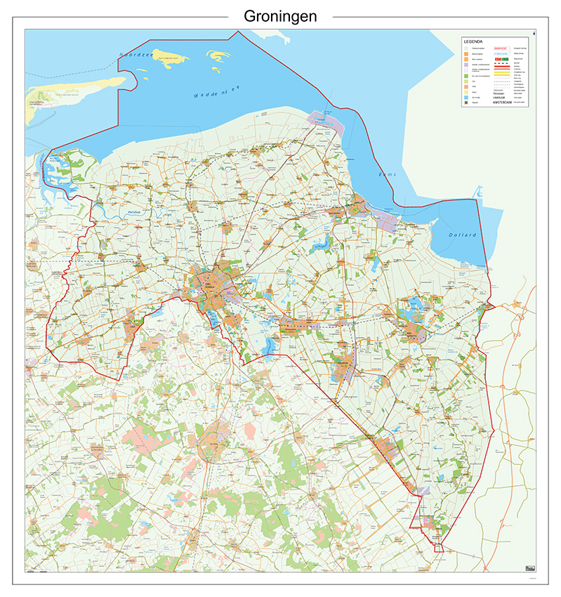
Zeer duidelijke provinciekaart van Groningen. Deze kaart is afgeleid van de topografische kaart waarbij na bewerking enkele details zijn weggelaten om het leesbaar te maken. Toegevoegd zijn enkele toeristische symbolen.
Het ophangsysteem bestaat uit uit twee donker plastic strips waar de kaart tussen is geklemd. Met het dikke, gelamineerde papier waar de kaart op gedrukt is, wordt het een mooi geheel. Schaal is 1:100.000.
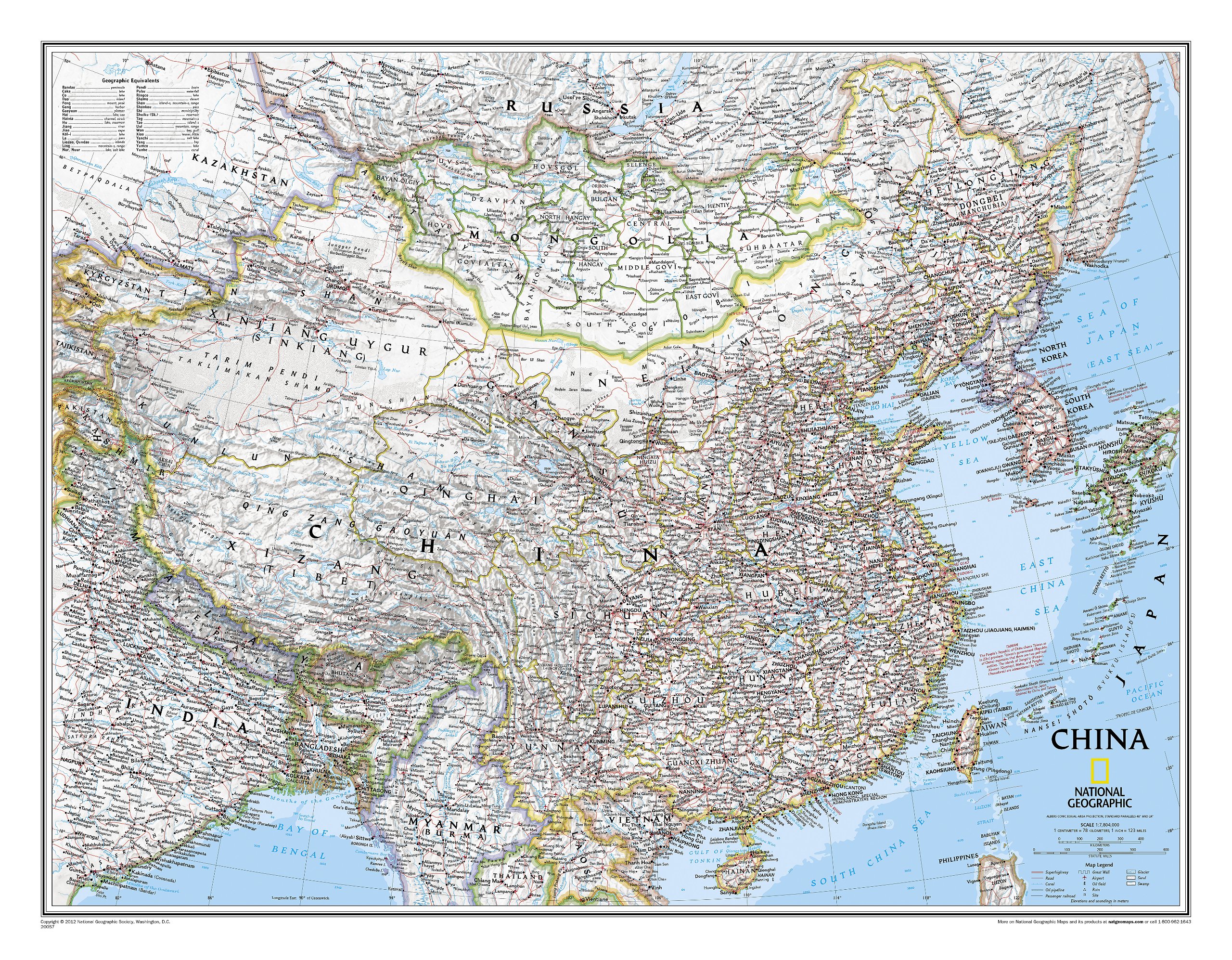
Decoratieve wandkaart van China. Naast de mooie kleuren staan er bijzonder veel plaatsen op vermeld. Het gaat soms een beetje ten kosten van de schoonheid van de kaart, maar daardoor wel zeer volledig.
This detailed political map of China by National Geographic accurately shows locations of provincial boundaries, cities and towns, major highways and roads, rivers and waterways, and other geographic features. Mongolia is also fully included in the map, as well as portions of many other surrounding countries.
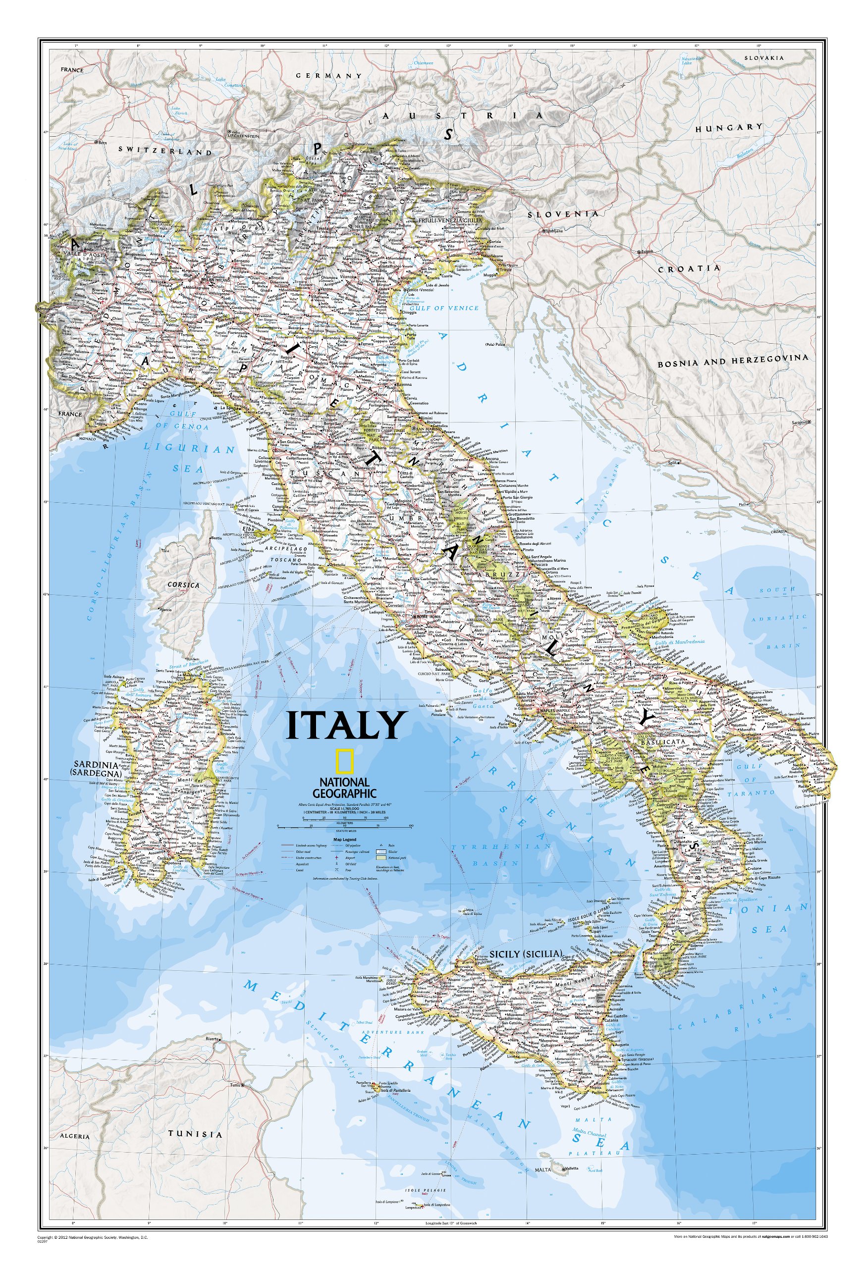
Decoratieve wandkaart van Italië. Naast de mooie kleuren staan er bijzonder veel plaatsen op vermeld.
This Italy Wall Map by National Geographic contains extensive political information with political boundaries clearly presented with different color-bands for each country. Beautifully shaded to show physical terrain, this map is both a useful reference tool and a quality piece of art, perfect for any home, office or classroom. • Political Boundaries • Major Cities and Capitals • Physical Terrain Shading • Mountain Ranges, Highest Point • Lakes, Seas, Rivers and Waterways • Sand, Swamp, Salt Desert, Dry Salt Lake or Coral Reef • Latitude and Longitude Lines • Basic Bathymetry (Ocean Depths) • Major Airports • National Parks • Major Roads and Highways • Oil Fields, Railroads, and Ruins

Decoratieve wandkaart van Griekenland. Naast de mooie kleuren staan er bijzonder veel plaatsen op vermeld.
The classic National Geographic wall map of Greece shows this beautiful area in uncompromisingly accurate detail. The map includes political boundaries, cities and towns, bodies of water, major roadways, airports, and many other geographic details
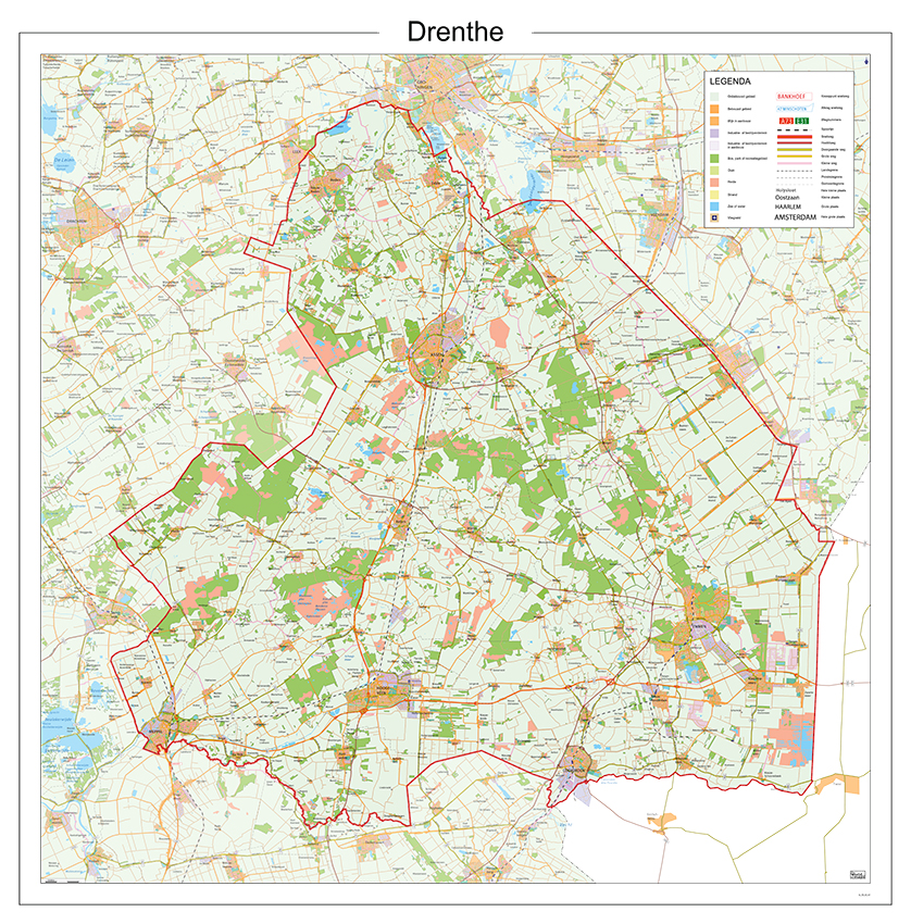
Gedetailleerde kaart van Drenthe. Alle plaatsen, wegen, wateren en spoorlijnen zijn afgebeeld. Ook het grondgebruik is aangegeven. Met duidelijke legenda.
Het ophangsysteem bestaat uit uit twee donker plastic strips waar je de kaart tussen kunt klemmen. Met het dikke papier waar de kaart op gedrukt is, wordt het een mooi geheel. Schaal is 1:100.000.

Fraaie politieke kaart van het continent, waarbij vooral de politieke aspecten heel duidelijk te lezen zijn. Alle landen hebben verschillende kleuren, steden en belangrijke verbindingen zijn goed te vinden. Geplastificeerde uitvoering. Let op: deze heeft geen metalen strips, de kaart is simpelweg te groot daarvoor. Wel is er nog een optie met houten stokken
Maps International’s European political wall map is huge! Our European political wall map is the size of a Smart Car and is the largest single sheet map available to buy.
European Map details: Politically coloured wall map of Europe features countries marked in a different colour, with international boundaries shown. All major towns and cities of Europe are featured within our huge map, and the country's capital cities are clearly marked. The map contains hill and sea shading adding to the vibrant overall effect. The wall map also contains a section showing the different flags of countries in Europe.
Map uses: As with most of our maps, the huge Europe political wall map is available in a variety of finishes making it suitable for the home, office or classroom. Just select your desired map finish from the options on the right.
If you are looking to buy a map of Europe, you won't be disappointed with this huge, stunning wall map.

Fraaie kaart van het continent waarbij zowel de natuurkundige als de politieke aspecten zichtbaar zijn. Alle bezettingsstations, berggebieden en landingsplaatsen staan er op.
Maps International's collection of continental maps would not be complete without this political Antarctica map.
The Antarctica map includes information from the British Antarctic Survey on scientific research. Information on Antarctica's climate and resources is included and as you would expect with a political map, the territory divisions are shown. Shown also are the major expedition routes, camps and weather stations on Antarctica. Map features hill shading, also contains information on the flora and fauna of Antarctica.
The map provides a great opportunity to learn more about a continent that many of us will never visit. Maps International's Antarctica map is available either plain or laminated making it ideal for classrooms or those with an interest in the South Pole and surrounding areas.
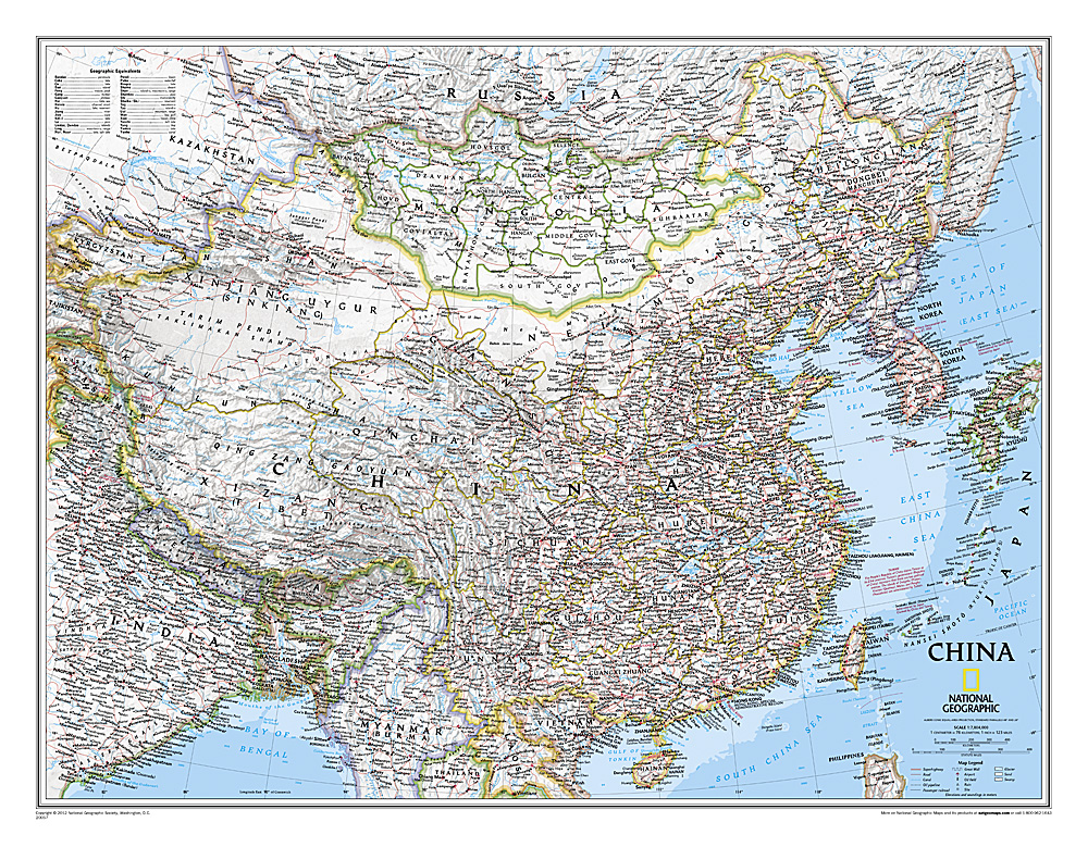
Decoratieve wandkaart van China. Naast de mooie kleuren staan er bijzonder veel plaatsen op vermeld. Het gaat soms een beetje ten kosten van de schoonheid van de kaart, maar daardoor wel zeer volledig.
This detailed political map of China by National Geographic accurately shows locations of provincial boundaries, cities and towns, major highways and roads, rivers and waterways, and other geographic features. Mongolia is also fully included in the map, as well as portions of many other surrounding countries.
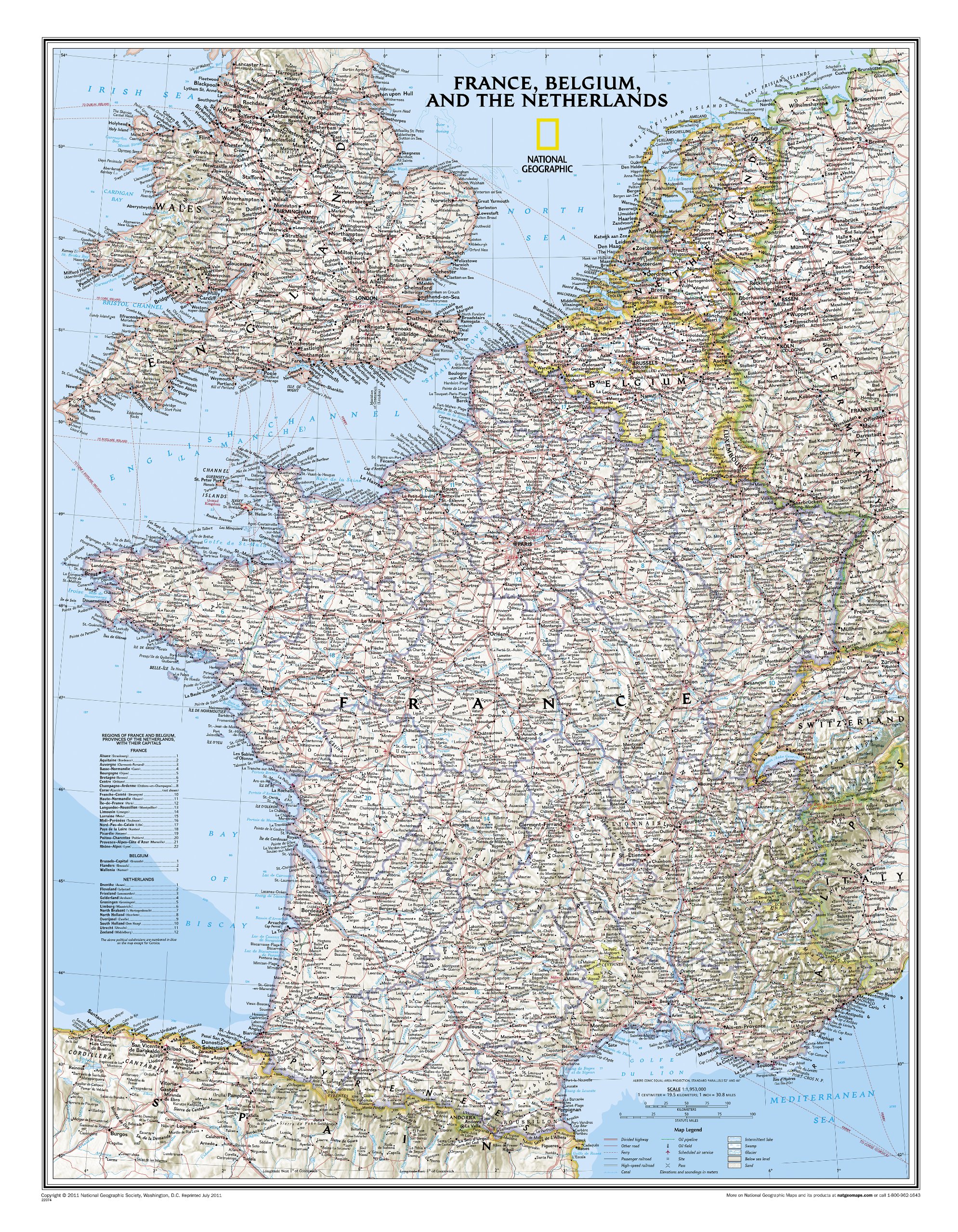
Our classic wall map of France, Belgium, and the Netherlands shows political boundaries, major highways and roads, cities and towns, and a wealth of other incredibly accurate geographic detail.
n France the map shows the division of the country into regions, with a list of their names and regional capitals (curiously, Corsica is not included on the map – what would Napoleon think of that?). The map also provides plenty of names of both geographical features (Pyrenees, Cevennes, etc) and the country’s traditional historical regions (Gascony, Maine, Bourbonais, etc). National parks are highlighted.
Within Belgium the map indicates the division into Flanders, Wallonia and the Brussels Region and in the Netherlands boundaries of the country’s administrative provinces are marked.
Topography is shown by relief shading and within the Netherlands the areas below the sea level are also indicated. The map shows the network of main road and rail connections, local airports, as well as ferry links.

>Our classic wall map of France, Belgium, and the Netherlands shows political boundaries, major highways and roads, cities and towns, and a wealth of other incredibly accurate geographic detail.
France the map shows the division of the country into regions, with a list of their names and regional capitals (curiously, Corsica is not included on the map – what would Napoleon think of that?). The map also provides plenty of names of both geographical features (Pyrenees, Cevennes, etc) and the country’s traditional historical regions (Gascony, Maine, Bourbonais, etc). National parks are highlighted.
Within Belgium the map indicates the division into Flanders, Wallonia and the Brussels Region and in the Netherlands boundaries of the country’s administrative provinces are marked.
Topography is shown by relief shading and within the Netherlands the areas below the sea level are also indicated. The map shows the network of main road and rail connections, local airports, as well as ferry links.

Fraaie politieke kaart van het continent, waarbij vooral de politieke aspecten heel duidelijk te lezen zijn. Alle landen hebben verschillende kleuren, steden en belangrijke verbindingen zijn goed te vinden.
Geplastificeerd, zonder ophangsysteem.
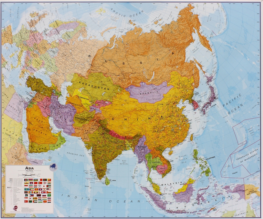
Maps International's political wall map of Asia shows all countries from Turkey in the West to Japan in the East, down to Indonesia in the South of Asia. The largest and most populated continent, Asia has a lot to fit onto a map! Rest assured though, with Maps International's high quality of mapping nothing is missed out!
This political wall map of Asia features countries marked in different colours, with international borders clearly shown. The map's key shows the flags from the countries displayed in this map. This Asia physical wall map also contains city population detail, capital cities and all the major towns and cities in this continent of Asia.

Fraaie kaart van het continent waarbij zowel de natuurkundige als de politieke aspecten zichtbaar zijn. Alle bezettingsstations, berggebieden en landingsplaatsen staan er op. Dit is een geplastificeerde versie.
Maps International's collection of continental maps would not be complete without this political Antarctica map.
The Antarctica map includes information from the British Antarctic Survey on scientific research. Information on Antarctica's climate and resources is included and as you would expect with a political map, the territory divisions are shown. Shown also are the major expedition routes, camps and weather stations on Antarctica. Map features hill shading, also contains information on the flora and fauna of Antarctica.
The map provides a great opportunity to learn more about a continent that many of us will never visit. Maps International's Antarctica map is available either plain or laminated making it ideal for classrooms or those with an interest in the South Pole and surrounding areas.

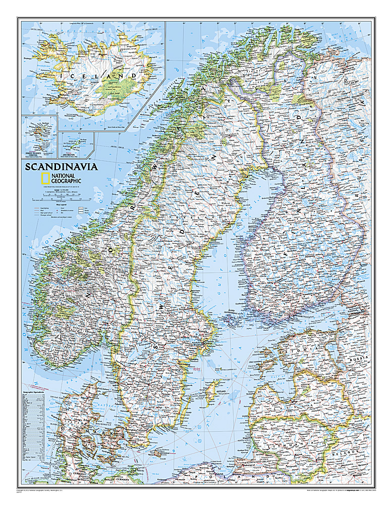
Prachtige wandkaart van Scandinavië met een inzet van IJsland. Hele duidelijke kaart waar door het kleurgebruik de natuurkundige aspecten als hoogte, bergen en fjorden heel goed uitkomt. Daarnaast zjin er belangrijke geografische aspecten als veel plaatsen en een behoorlijk aantal wegen zichtbaar.
Deze kaart heeft een afmeting van 75 cm breed en 100 cm hoog.
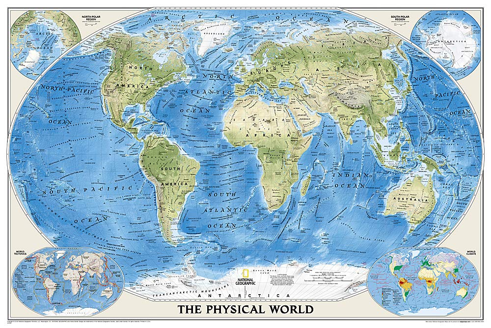
Bijzonder fraaie natuurkundige kaart van National Geographic waarbij het accent ligt op de fysische aspecten van de aarde met veel details van de oceanen. Een schoonheid aan de muur!
Deze versie is geplastificeerd.
Our World Physical - Ocean Floor map highlights the Earth's land and undersea forms with exquisite hand-painted relief. Drawn in the Winkel Tripel projection to minimize distortion of the landforms. Two corner inset maps show the Earth's crust and world climatic zones. Scale: 1:24,031,000.
Superb representation of the ocean floor makes this 175.5 x 121.5cm (5ft 9” x 4ft approx.) physical map of the world one of the most interesting titles in the National Geographic Society’s long list of wall maps. Drawn with great skill to achieve a 3-D effect, ocean floor plains, basins, continental shelves, trenches, ridges and fractures are shown with their names, indicating in many places their depth in metres.
On land masses relief shading shows the mountain chains, whilst the colouring indicates different types of terrain: arid regions, vegetation, tundra, etc. The map has names of mountain ranges, plateaux, deserts, plains, etc., but no country names or boundaries, with only selected major cities marked.
The two Polar Regions are presented as insets in the top corners, while at the bottom two colourful maps of the world show the tectonic plates with the earth crust coloured according to its age, plus the world’s climatic zones. Projection is Winkel Tripel, which reduces distortion of land masses as they near the poles.
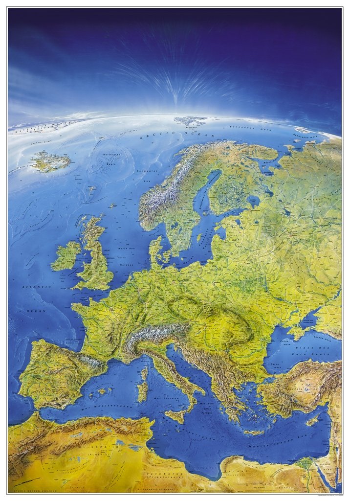
Een prachtige wandkaart van Europa waarin in vogelvlucht-perspectief de natuurkundige aspecten van Europa mooi te zien zijn.
Der Blick des Betrachters wandert von der gleißenden Helle der Nordpol-Kappe über hellgrüne Wälder zu den weißen Gipfeln der Alpen. Weiter geht es über den Kaukasus bis zu den tiefblauen Gestaden des Mittelmeers, dessen Grund ebenfalls plastisch dargestellt ist. Das helle Gelb-Rot der afrikanischen Wüsten bildet gen Süden den Abschluß des Panoramas.
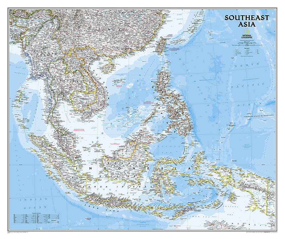
The Southeast Asia Political Map is a detailed reference map containing National Geographic’s clear visual presentation in a bright and appealing color palette. The map contains thousand of place names, accurate political boundaries, and infrastructure, making it the perfect reference for student, home, or business.
This detailed wall map of Southeast Asia by National Geographic includes Indonesia, New Guinea, the Phillipines, Malaysia, Thailand, Myanmar, Cambodia and Vietnam. Coverage includes the whole of Indonesia and the Philippines, and extends north to cover China as far as Hangzhou and, in the north-western corner, Bhutan.
Details featured on this Southeast Asia Wall Map include:
• Political Boundaries
• Major Cities and Capitals
• Physical Terrain Shading
• Mountain Ranges, Highest Point
• Lakes, Rivers and Waterways
• Latitude and Longitude Lines
• Basic Bathymetry (Ocean Depths)
• Major Airports
• National Parks

Fraaie politieke kaart van het continent, waarbij vooral de politieke aspecten heel duidelijk te lezen zijn. Alle landen hebben verschillende kleuren, steden en belangrijke verbindingen zijn goed te vinden. Geplastificeerde uitvoering met blauw metalen strips boven en onder de kaart waardoor deze eenvoudig is op te hangen.
Maps International's South America political wall map shows all countries in South America from Venezuela and the Grenadine Islands down to Argentina and the most Southerly points of Chile and the Falkland Islands.
This political wall map of South America features countries marked in different colours, with international borders clearly shown. The map's key shows the flags from the countries displayed in this map. This South American political wall map also contains city population detail, capital cities and all the major towns and cities in this continent of South America.
Maps International's North America map is available either plain or laminated. Major motorways and transport lines are shown making it an ideal map for your planning and logistics needs in this South American continent.

Door het heldere en vrij felle kleurgebruik is deze kaart uitermate geschikt voor scholen, kantoren of gewoon als politieke wereldkaart thuis. Bedenk wel dat deze maat klein is om van ver af goed te kunnen lezen.De kleurstellig is zodanig dat elk land zich zeer goed onderscheidt van haar buren. De natuurkundige aspecten zijn minder goed te zien, al worden de gebergten door schaduwwerking goed uitgelicht. De nadruk ligt echter duidelijk op een ‘gewone’ wereldkaart. De belettering is uitstekend leesbaar door vetgedrukte naamgeving. Nederlandstalig, maten: 68 x 45, met vlaggen. Dit is de enige goede kaart die op een deur past!

Staatkundige kaart van Zuid-Amerika (in kleur). De kaart wordt verzonden in een koker.
This classic map of South America shows political boundaries, place names, airports, major roads and highways, and other geographic features for the entire continent. 36 x 46 inches (approx). Scale size: 1:7,105,000.
Founded in 1915 as the Cartographic Group, the first division of the National Geographic Society, National Geographic Maps has been responsible for illustrating the world around us through the art and science of mapmaking.
Today, National Geographic Maps continues this mission by creating the world s best wall maps, recreation maps, atlases, and globes which inspire people to care about and explore their world. All proceeds from the sale of National Geographic maps go to support the Society s non-profit mission to increase global understanding and promote conservation of our planet through exploration, research, and education.
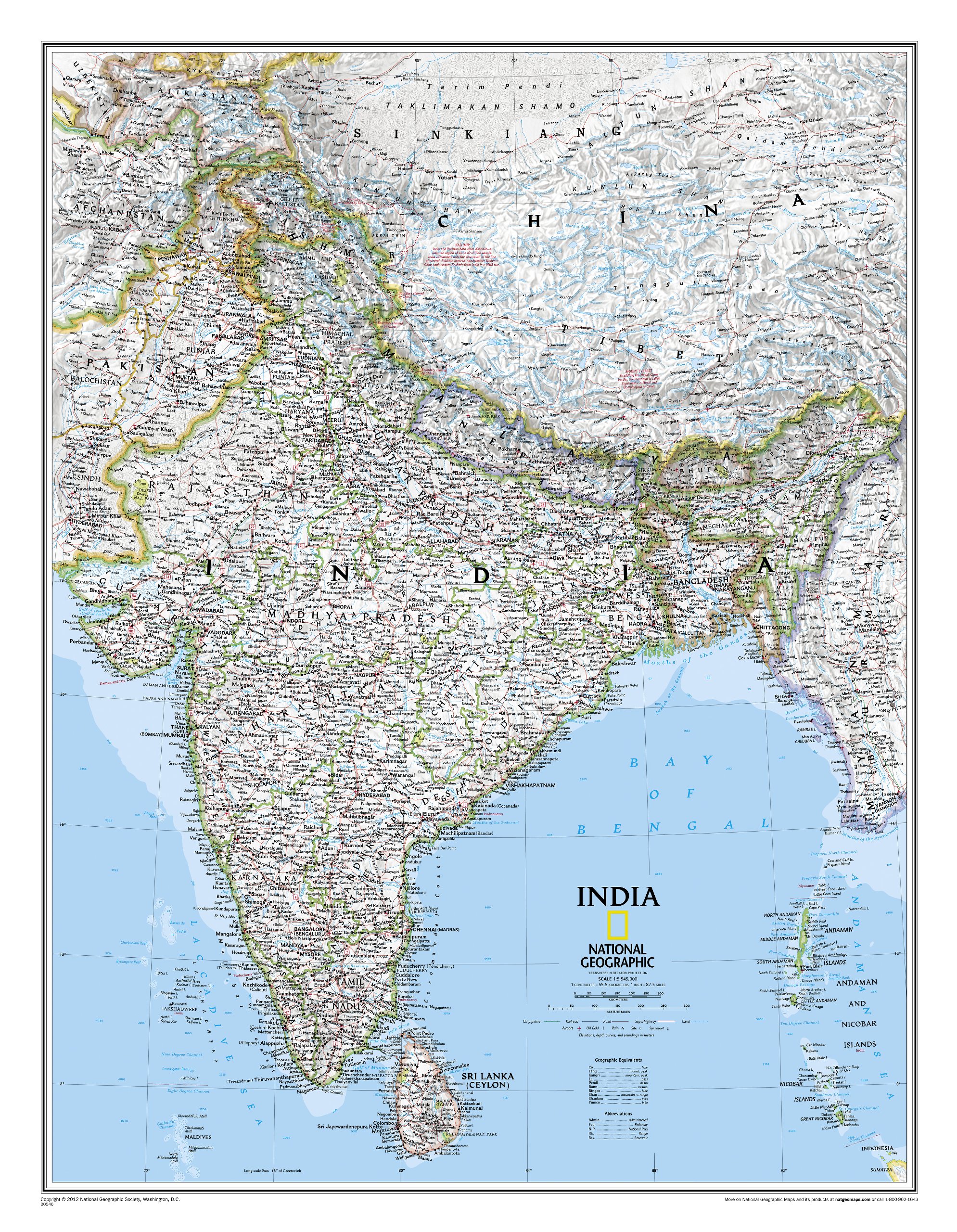
See India as only National Geographic can depict it. This new reference map is one of the most detailed and comprehensive ever published for India and southern Asia. It includes India, Sri Lanka, Nepal, Bangladesh, Bhutan, Tajikistan, and portions of China, Pakistan, Afghanistan, and Myanmar. The India map is punctuated with thousands of place names, and embellished with shaded relief which highlights the region's dramatic topography in such places as the Tibetan Plateau and the Himalaya.
Fraaie politieke kaart van het continent, waarbij vooral de politieke aspecten heel duidelijk te lezen zijn. Alle landen hebben verschillende kleuren, steden en belangrijke verbindingen zijn goed te vinden. geplastificeerde versie.
Maps International's large European political wall map is great looking map available to buy.
This politically coloured wall map of Europe features countries marked in a different colour, with international boundaries shown. All major towns and cities are featured within our large map of Europe. Map contains hill and sea shading adding to the vibrant overall effect. The wall map also contains a section showing the different flags of countries in Europe.
Maps International's Europe map is available either plain or laminated. If you are looking to buy a map of Europe, you won't be disappointed with this large stunning wall map.
Fraaie politieke kaart van het continent, waarbij vooral de politieke aspecten heel duidelijk te lezen zijn. Alle landen hebben verschillende kleuren, steden en belangrijke verbindingen zijn goed te vinden. Geplastificeerde uitvoering met blauw metalen strips boven en onder de kaart waardoor deze eenvoudig is op te hangen.
Maps International's North America political wall map covers a huge expanse of land from Alaska and Canada through the United States down to Mexico, Central America and the Caribbean. One of the finest maps money can buy!
This political wall map of North America features countries shown in different colours, international boundaries and major transport networks. The wall map also contains a panel of flags relating to the countries shown in this North American continent map. Also shown is city population detail, capital cities and all the major towns and cities in this continent of North America.
Maps International's North America map is available either plain or laminated. Ideal for an office, classroom or when planning a trip to this American continent.
Fraaie politieke kaart van het continent, waarbij vooral de politieke aspecten heel duidelijk te lezen zijn. Alle landen hebben verschillende kleuren, steden en belangrijke verbindingen zijn goed te vinden. Papieren versie, geen ophangsysteem.
Maps International's political wall map of Asia shows all countries from Turkey in the West to Japan in the East, down to Indonesia in the South of Asia. The largest and most populated continent, Asia has a lot to fit onto a map! Rest assured though, with Maps International's high quality of mapping nothing is missed out!
This political wall map of Asia features countries marked in different colours, with international borders clearly shown. The map's key shows the flags from the countries displayed in this map. This Asia physical wall map also contains city population detail, capital cities and all the major towns and cities in this continent of Asia.
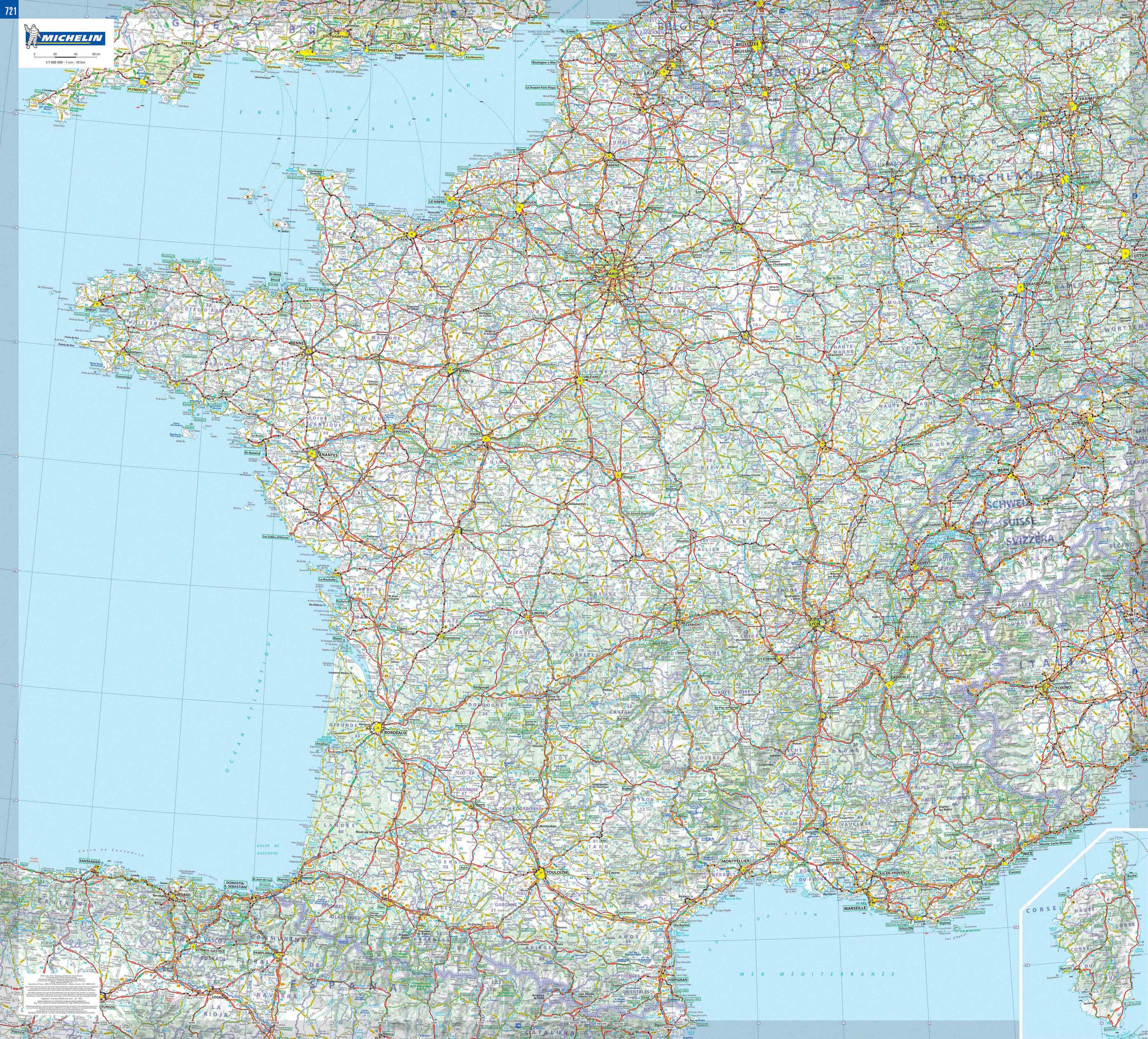
Dubbelzijdig geplastificeerde wandkaart van de klassieke overzichtskaart van Michelin Frankrijk. Als altijd zeer overzichtelijk en voorzien van een mooie heldere kleurstelling. Prachtig aan de muur!
Op deze kaart is het wegennet identiek aan de gevouwen kaart van Frankrijk ( 721 ) . De meest verkochte wegenkaart van Frankrijk met het volledige wegennet van hoofdwegen en secundaire wegen. De kaart bevat ook zeer veel plaatsnamen.

Decoratieve wandkaart van Duitsland. Naast de mooie kleuren staan er bijzonder veel plaatsen op vermeld.
National Geographic's political map of Germany includes everything from country boundaries, major roads, towns and cities, airports, bodies of water, and other geographic details. It's a great addition to any classroom, office, or home.
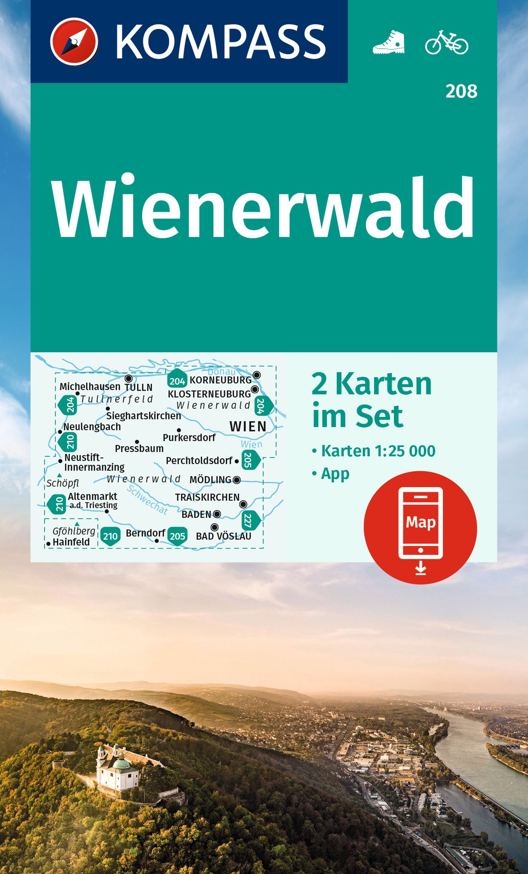
Goede 2-delige wandelkaartenset met vrijwel alle topografische details als hoogtelijnen, vegetatie, schaduwtekening maar ook de ingetekende wandelroutes en in veel gevallen ook fietsroutes (MTB). Gevaarlijke routes worden als zodanig weergegeven met een bepaalde markering. Berghutten en campings zijn goed terug te vinden op deze kaarten.
Daarnaast staan de toeristische bezienswaardigheden met symbolen vermeld. Kleurgebruik kan soms vrij fel overkomen, daardoor oogt deze detailkaart wellicht wat druk, maar het blijft een goed leesbare kaart. Sommige kaarten zijn geplastificeerd, maar helaas niet allemaal. De graden staan aan de zijkanten van de kaart, daardoor te gebruiken voor GPS.
Steden/dorpen/gebieden:
Tulln, Korneuburg, St. Andrä-Wördern, Klosterneuburg, Sieghartskirchen, Neulengbach, Purkersdorf, Pressbaum, Neustift-Innermanzig, Kaltenleutgeben, Perchtoldsdorf, Mödling, Alland, Traiskirchen, Altenmarkt, Kaumberg, Baden, Bad Vöslau, Berndorf, Hainfeld, Oberwaltersdorf
Bergen/dalen:
Schöpfl, Hoher Lindkogel, Gföhlberg
Rivieren/meren:
Große Tulln, Kleine Tulln, Donau (am nördlichen Kartenrand), Wien, Mödling, Triesting, Schwechat
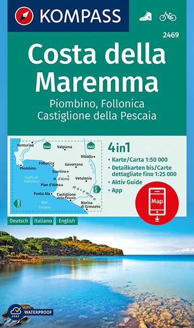
Goede wandelkaart met vrijwel alle topografische details als hoogtelijnen, vegetatie, schaduwtekening maar ook de ingetekende wandelroutes en in veel gevallen ook fietsroutes (MTB). Gevaarlijke routes worden als zodanig weergegeven met een bepaalde markering. Berghutten en campings zijn goed terug te vinden op deze kaarten.
Daarnaast staan de toeristische bezienswaardigheden met symbolen vermeld. Kleurgebruik kan soms vrij fel overkomen, daardoor oogt deze detailkaart wellicht wat druk, maar het blijft een goed leesbare kaart. Sommige kaarten zijn geplastificeerd, maar helaas niet allemaal. De graden staan aan de zijkanten van de kaart, daardoor te gebruiken voor GPS.
Steden/dorpen/gebieden:
Piombino, Venturina, Follonica, Scarlino, Valpiana, Pian d'Alma, Vetulonia, Ribolla, Marina di Grosseto, Castiglione della Pescaia, Punta Ala, Gavorrano
Rivieren/meren:
F. Cornia, F. Bruna

Fraaie politieke kaart van het continent, waarbij vooral de politieke aspecten heel duidelijk te lezen zijn. Alle landen hebben verschillende kleuren, steden en belangrijke verbindingen zijn goed te vinden. Geplastificeerde uitvoering met blauw metalen strips boven en onder de kaart waardoor deze eenvoudig is op te hangen.
Maps International's large European political wall map is great looking map available to buy.
This politically coloured wall map of Europe features countries marked in a different colour, with international boundaries shown. All major towns and cities are featured within our large map of Europe. Map contains hill and sea shading adding to the vibrant overall effect. The wall map also contains a section showing the different flags of countries in Europe.
Maps International's Europe map is available either plain or laminated. If you are looking to buy a map of Europe, you won't be disappointed with this large stunning wall map.

Fraaie politieke kaart van het continent, waarbij vooral de politieke aspecten heel duidelijk te lezen zijn. Alle landen hebben verschillende kleuren, steden en belangrijke verbindingen zijn goed te vinden. Geplastificeerde versie.
Afwerking: geplastificeerd
De wandkaart wordt afgewerkt met een inkapselingsproces. Inkapseling betekent dat de kaarten met warmte worden geperst tussen twee vellen film van industriële kwaliteit. Houd er rekening mee dat de randen van deze kaart niet zijn geplastificeerd.
Inkapseling geeft de kaart een schrijf- / veegafwerking, wat betekent dat met een droog afveegbare marker elk schrift op de kaart kan worden weggeveegd.
Maps International's South America political wall map shows all countries in South America from Venezuela and the Grenadine Islands down to Argentina and the most Southerly points of Chile and the Falkland Islands.
This political wall map of South America features countries marked in different colours, with international borders clearly shown. The map's key shows the flags from the countries displayed in this map. This South American political wall map also contains city population detail, capital cities and all the major towns and cities in this continent of South America.
Maps International's North America map is available either plain or laminated. Major motorways and transport lines are shown making it an ideal map for your planning and logistics needs in this South American continent.
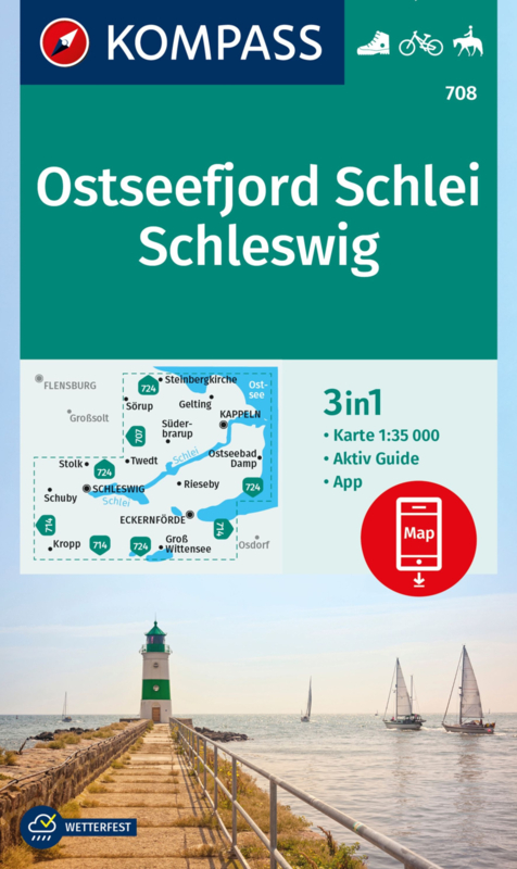
Goede wandelkaart met vrijwel alle topografische details als hoogtelijnen, vegetatie, schaduwtekening maar ook de ingetekende wandelroutes en in veel gevallen ook fietsroutes (MTB). Gevaarlijke routes worden als zodanig weergegeven met een bepaalde markering. Berghutten en campings zijn goed terug te vinden op deze kaarten.
Daarnaast staan de toeristische bezienswaardigheden met symbolen vermeld. Kleurgebruik kan soms vrij fel overkomen, daardoor oogt deze detailkaart wellicht wat druk, maar het blijft een goed leesbare kaart. De graden staan aan de zijkanten van de kaart, daardoor te gebruiken voor GPS.
Met Aktiv Guide waarin bezienswaardigheden en wandelingen staan vermeld.
Steden/dorpen/gebieden:
Steinbergkirche, Gelting, Sörup, Kappeln, Süderbrarup, Ostseebad Damp, Twedt, Stolk, Schleswig, Schuby, Rieseby, Eckernförde, Kropp, Groß Wittensee
Rivieren/meren:
Schlei
Die KOMPASS Wanderkarte ist jetzt noch übersichtlicher und besser lesbar. Die kostenlose App für unterwegs gibt es auch noch dazu. Das bildet die perfekte Grundlage für die Planung einer Wandertour. Die präzise Kartografie zeigt alle begehbaren Wanderwege inklusive Klassifizierung. Informationen wie Schwimmbäder, Klettersteige, Kinderspielplätze, Hütten und vieles mehr sind in der Karte ebenfalls enthalten

Fraaie politieke kaart van het continent, waarbij vooral de politieke aspecten heel duidelijk te lezen zijn. Alle landen hebben verschillende kleuren, steden en belangrijke verbindingen zijn goed te vinden. Geplastificeerde uitvoering.
Geplastificeerd.
Maps International's Africa political wall map shows the whole African continent from Morocco in the north, to South Africa and Madagascar in the south.
This political wall map of Africa features countries marked in different colours, with international borders clearly shown. The map's key shows a panel of flags from each of the countries displayed in this African continent map. This political wall map of Africa also contains population detail, capital cities and all the major towns and cities in this continent.
As with most of Maps International's maps, the Africa political wall map, is available either plain or laminated. Ideal size for an office or classroom or for planning a trip around Africa.
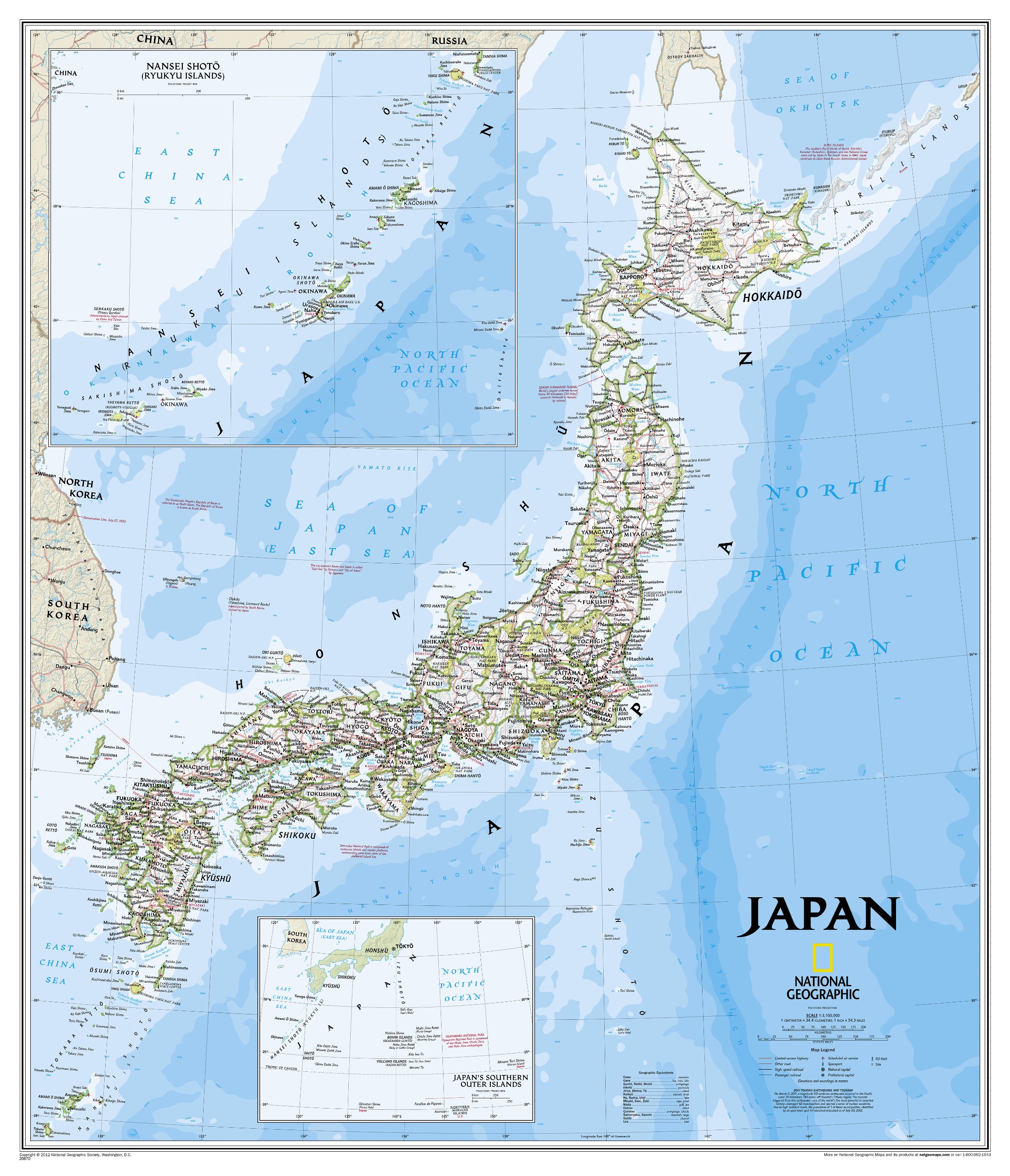
This classic-style map of Japan shows political boundaries, major highways and roads, cities and towns, airports, and other geographic details. Thousands of place-names and exact borders are carefully researched by National Geographic’s map researchers and editors ensuring the utmost accuracy.
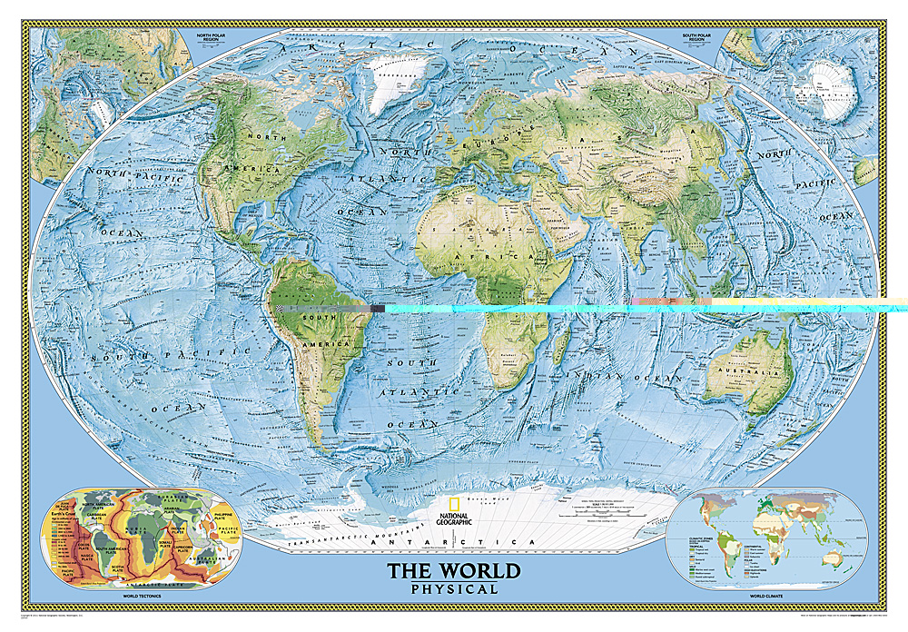
Bijzonder fraaie natuurkundige kaart van National Geographic waarbij het accent ligt op de fysische aspecten van de aarde met veel details van de oceanen. Een schoonheid aan de muur!
Our World Physical - Ocean Floor map highlights the Earth's land and undersea forms with exquisite hand-painted relief. Drawn in the Winkel Tripel projection to minimize distortion of the landforms. Two corner inset maps show the Earth's crust and world climatic zones. Scale: 1:24,031,000.
Superb representation of the ocean floor makes this 175.5 x 121.5cm (5ft 9” x 4ft approx.) physical map of the world one of the most interesting titles in the National Geographic Society’s long list of wall maps. Drawn with great skill to achieve a 3-D effect, ocean floor plains, basins, continental shelves, trenches, ridges and fractures are shown with their names, indicating in many places their depth in metres.
On land masses relief shading shows the mountain chains, whilst the colouring indicates different types of terrain: arid regions, vegetation, tundra, etc. The map has names of mountain ranges, plateaux, deserts, plains, etc., but no country names or boundaries, with only selected major cities marked.
The two Polar Regions are presented as insets in the top corners, while at the bottom two colourful maps of the world show the tectonic plates with the earth crust coloured according to its age, plus the world’s climatic zones. Projection is Winkel Tripel, which reduces distortion of land masses as they near the poles.
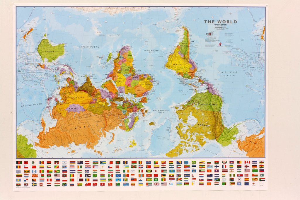
Een totaal andere kijk op de wereld: hang het eens ondersteboven! De mooie heldere kaart van Maps International nu in een upside-down uitvoering. Engelstalig, geplastificeerd, met vlaggen
Afwerking: geplastificeerd
De wandkaart wordt afgewerkt met een inkapselingsproces. Inkapseling betekent dat de kaarten met warmte worden geperst tussen twee vellen film van industriële kwaliteit. Houd er rekening mee dat de randen van deze kaart niet zijn geplastificeerd.
Inkapseling geeft de kaart een schrijf- / veegafwerking, wat betekent dat met een droog afveegbare marker elk schrift op de kaart kan worden weggeveegd.
View the world from a different direction with Maps International's large political upside down world wall map.
Map details: This is an upside down world wall map with everything reversed! The south is at the top of the map, the north is at the base and the southern hemisphere is now at the top. The countries you expect to see in the east are now on the left of the map, and those on the west traditionally, are now on the right of this upside down map.
This large upside down political map has countries marked in different colours according to international country boundaries. Capital cities (including approximate population size) and hill shading are also shown on this upside down political world wall map.

This earth-toned, executive-style map of England and Wales shows political boundaries, major highways and roads, cities and towns, airports, and other geographic details. Thousands of place-names and exact borders are carefully researched by National Geographic's map researchers and editors ensuring the utmost accuracy.

Gedetailleerde wandel- en wegenkaart met aanduiding van de wandelwegen, lijst van hotels en toeristische informatie. Voor alle doeleinden een zeer geschikte kaart. The complete road network, all villages, beaches, touristic sights and many more, clearly presented in a dependable and user-friendly map

This Central America Wall Map by National Geographic contains extensive political information with political boundaries clearly presented with different color-bands for each country. Beautifully shaded to show physical terrain, this map is both a useful reference tool and a quality piece of art, perfect for any home, office or classroom.
Details featured on this wall map of Central America include:
• Political Boundaries
• Major Cities and Capitals
• Physical Terrain Shading
• Mountain Ranges, Highest Point
• Lakes, Seas, Rivers and Waterways
• Sand, Swamp, Salt Desert, Dry Salt Lake or Coral Reef
• Latitude and Longitude Lines
• Basic Bathymetry (Ocean Depths)
• Major Airports
• National Parks
• Major Roads and Highways
• Oil Fields, Railroads, and Ruins
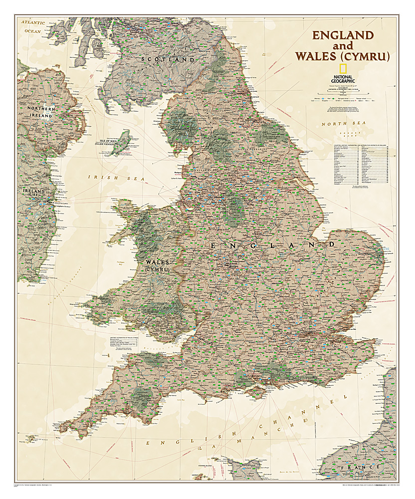
This earth-toned, executive-style map of England and Wales shows political boundaries, major highways and roads, cities and towns, airports, and other geographic details. Thousands of place-names and exact borders are carefully researched by National Geographic's map researchers and editors ensuring the utmost accuracy.
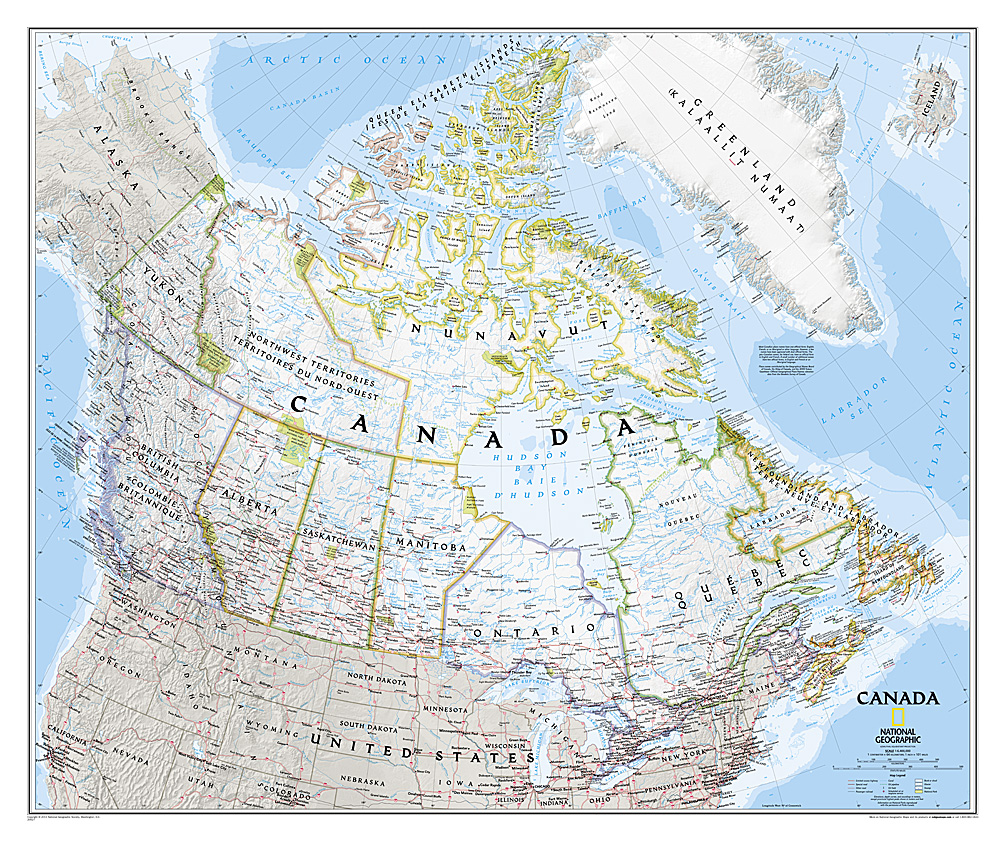
Decoratieve wandkaart van Canada. Naast de mooie kleuren staan er bijzonder veel plaatsen op vermeld.
This beautiful wall-map from National Geographic depicts Canada and the areas surrounding the Great Lakes in beautiful and accurate detail. Included in the map are Canadian province and US State boundaries, cities and towns, lakes and waterways, major geographic features, roadways, and other geographic details.
Our most detailed wall map of Canada, features the classic National Geographic reference styling. Features thousands of place names, accurate political boundaries, national parks, archeological sites, and major infrastructure networks such as roads, canals, ferry routes, and railroads. Canada s diverse terrain is detailed through accurate shaded relief, coastal bathymetry, and symbolism for water features and other landforms. This wall map depicts Canada and the areas surrounding the Great Lakes. Includes Canadian provinces and US State boundaries.
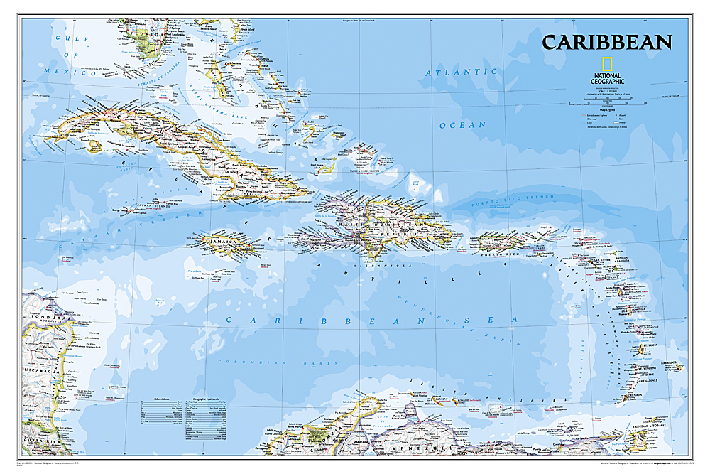
Completely redesigned and updated, National Geographic Maps' Caribbean Classic wall map is one of the most authoritative maps for the islands of the Caribbean Sea. This new edition shows the entire region in exceptional detail, with coverage extending from the tip of Florida to the northern extents of Colombia and Venezuela, east to Barbados, and west to the eastern edge of Honduras, Costa Rica, and Nicaragua. Updated bathymetry reveals the remarkable seafloor variation of the Caribbean including the Puerto Rico Trench, the deepest point in the Atlantic Ocean at 8,605 meters (28,232 feet).
Caribbean Classic is a perfect tool for business or education reference, and a beautiful addition to any décor. Shown on the map are over 1,000 named places including country capitals, primary and secondary towns; political boundaries, important infrastructure, and all key landforms. Useful and informative notes about the region's history and unique geography are spread throughout the map, providing the reader further understanding of the Caribbean's unique attributes. This classic-style wall map contains National Geographic's world-recognized proprietary fonts, and bright easy-to-read colors.
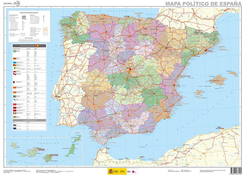
Administrative provinces of Spain shown in bright colours on a wall map at 1:2,250,000, size 70 x 50cm (27.5" x 20" approx), from IGN/CNIG - the country’s civilian survey organization, plus a panel of regional flags. Each province is presented in a different colour and the map also shows boundaries and names of administrative regions. Town symbols and names indicate their size and administrative status. The map shows the network of main roads and railways. Latitude and longitude lines are drawn at intervals of 1°. Map legend is in Spanish only.
Next to the map is a panel listing Spain’s autonomous regions, including Ceuta and Melilla, each with its flag, plus a list of its constituent provinces and their capitals.
Mapa General de España (Península Ibérica, Baleares, Canarias, Ceuta, Melilla y posesiones españolas en el norte de África) a escala 1:2.000.000, con división autonómica. Proyección Lambert.

National Geographic is a renowned authority in cartography. For 120 years the Society's maps have helped spread geographic knowledge around the globe. A vast database allows National Geographic to combine the latest data gained by space-age technology with innovative digital mapping techniques to create state-of-the-art political, physical, and thematic maps. The Society's meticulous research and attention to detail have established a standard of achievement that is unparalleled.
The rich tones of the Political Executive map combine the popular antique look with up-to-date information—elegant enough for the board room, study, or office, and contemporary enough to make it an ideal reference.

This colorful Europe political map clearly shows country boundaries, capitals, many major cities, bodies of water, airports, major highways and roads, and much more.
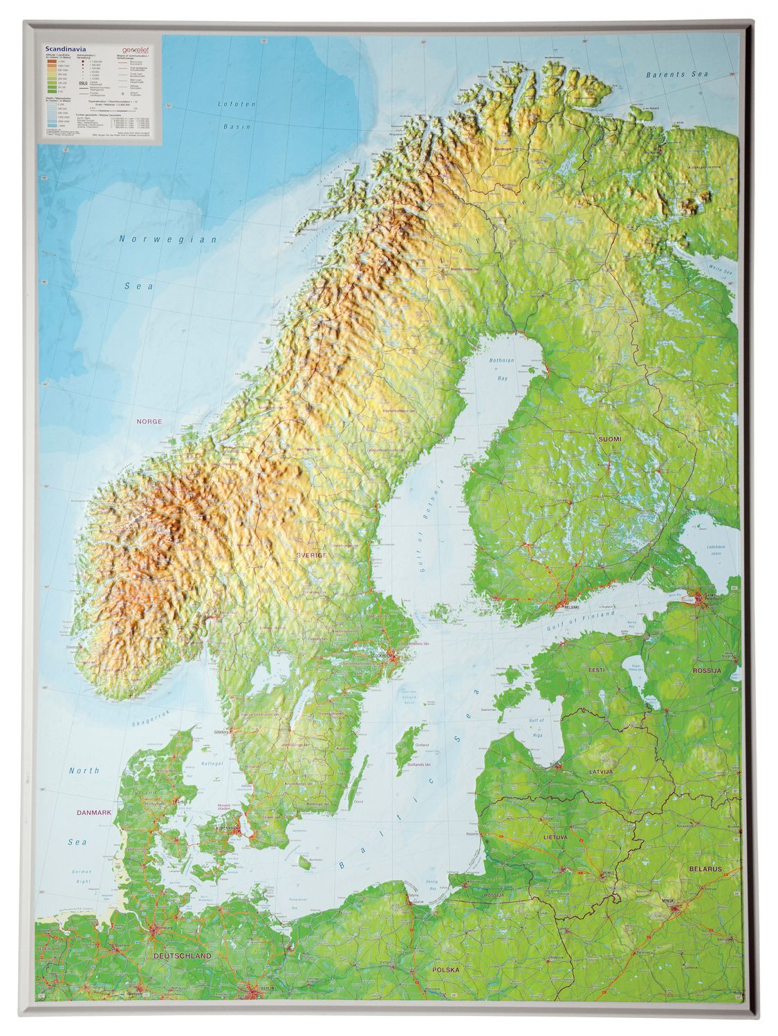
De uitgever van de kaart is de bekende Duitse uitgever GeoRelief GbR. Deze topografische kaart van Scandinavië heeft een hoge kwaliteit met prachtige kleuren (engelse versie). De kaart bevat de namen van grote steden, spoorwegen, wegennet, de namen van bergketens en internationale luchthavens. Gemaakt van een hoge kwaliteit kunststof. Extreem duurzaam.

Een schitterende en kleurrijke aquarel van de skyline van Berlijn. Een aanwinst voor elke muur.
A bright and colourful watercolour skyline of the city of Berlin. With bold, dynamic and exciting watercolours, the skyline of Berlin is brought to life, adding a contemporary splash of colour to any wall where this artwork is placed.
Printed on Silk Art Paper, a superior colour reproduction finish and provides high photo quality results.
200gsm silk: Coated in smooth silk material, combining strength and durability.

Een schitterende en kleurrijke aquarel van de skyline van Parijs. Een aanwinst voor elke muur.
A bright and colourful watercolour skyline of the city of Paris. With bold, dynamic and exciting watercolours, the skyline of Paris is brought to life, adding a contemporary splash of colour to any wall where this artwork is placed.
Printed on Silk Art Paper, a superior colour reproduction finish and provides high photo quality results.
200gsm silk: Coated in smooth silk material, combining strength and durability.

Een schitterende en kleurrijke aquarel van de skyline van Rome. Een aanwinst voor elke muur.
A bright and colourful watercolour skyline of the city of Rome. With bold, dynamic and exciting watercolours, the skyline of Rome is brought to life, adding a contemporary splash of colour to any wall where this artwork is placed.
Printed on Silk Art Paper, a superior colour reproduction finish and provides high photo quality results.
200gsm silk: Coated in smooth silk material, combining strength and durability.

This richly colored map of North America - featuring country boundaries, place names, major highways and roads, and bodies of water - is excellent for reference in your home or office. An inset map shows the Aleutian Islands off the coast of Alaska.
Mooie natuurkundige kaart van Griekenland met namen in het Grieks.
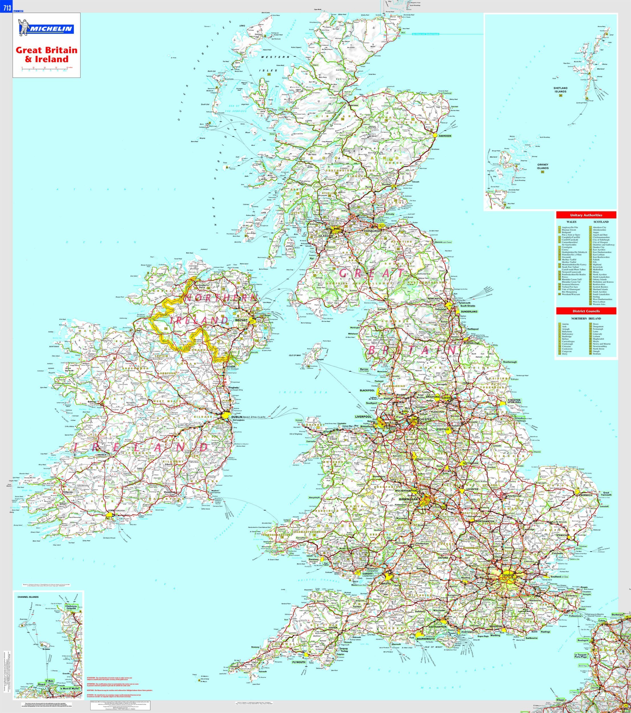
This Great Britain and Ireland wall map will give an overview of British and Irish cities, administrative boundaries, as well as primary and secondary road networks at a glance. This laminated map, suitable to use with marker pens, is presented on a scale 1/1,000,000 and measures 100 x 88 cm
National Geographic Wall Maps offer a special glimpse into current and historical events, and they inform about the world and environment. Offered in a variety of styles and formats, these maps are excellent reference tools and a perfect addition to any home, business or school. There are a variety of map options to choose from, including the world, continents, countries and regions, the United States, history, nature and space.

Study the countries of the Balkans with our new map featuring the classic National Geographic reference styling. Features thousands of place names, accurate political boundaries, national parks, and major infrastructure networks such as roads, canals, ferry routes, and railroads. The countries of the Balkans Classic map shows it's diverse terrain as detailed through accurate shaded relief, coastal bathymetry, and symbolism for water features and other landforms. Elevations of major peaks as well as depth soundings are expressed in meters.
Map coverage includes the countries of: Albania, Austria, Bosnia and Herzegovina, Bulgaria, Croatia, Hungary, Kosovo, Macedonia, Moldova, Montenegro, Romania, Slovenia, Vojvodina, as well as the outlying border countries of Greece, Italy, Slovakia, Turkey and Ukraine. Map features also includes listings for the counties of Hungary and Romania along with their respective capitals and the administrative divisions of Bosnia and Herzegovina.

Maps International's large physical wall map of Europe is one of the finest money can buy.
European Map details: Our large physical wall map of Europe features the natural terrain of the land, with countries marked and international borders shown. The map's key helps to identify the land elevation and water depth. This large European physical wall map also contains city population detail, national capitals and all the major towns and cities in Europe.
Map uses: As with most of our maps, the large physical wall map of Europe, is available in a range of finishes making it suitable for a variety of locations. Major motorways and transport lines are shown on this European wall map making it an ideal map for planning and logistics
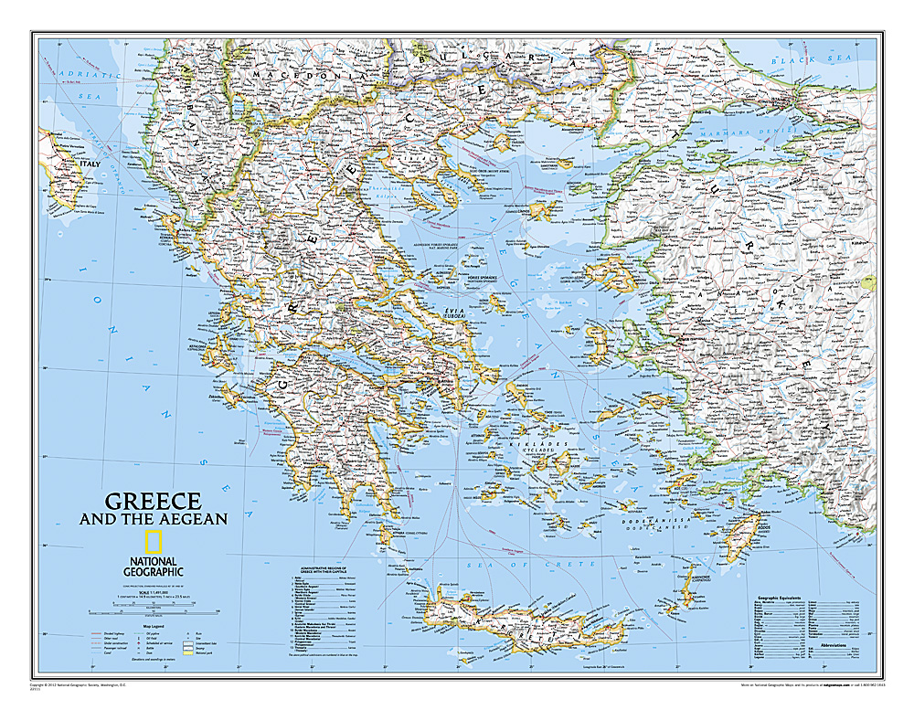
Decoratieve wandkaart van Griekenland. Naast de mooie kleuren staan er bijzonder veel plaatsen op vermeld.
The classic National Geographic wall map of Greece shows this beautiful area in uncompromisingly accurate detail. The map includes political boundaries, cities and towns, bodies of water, major roadways, airports, and many other geographic details

Our most detailed wall map of Canada, features the classic National Geographic reference styling. Features thousands of place names, accurate political boundaries, national parks, archeological sites, and major infrastructure networks such as roads, canals, ferry routes, and railroads. Canada’s diverse terrain is detailed through accurate shaded relief, coastal bathymetry, and symbolism for water features and other landforms. This wall map depicts Canada and the areas surrounding the Great Lakes. Includes Canadian provinces and US State boundaries.
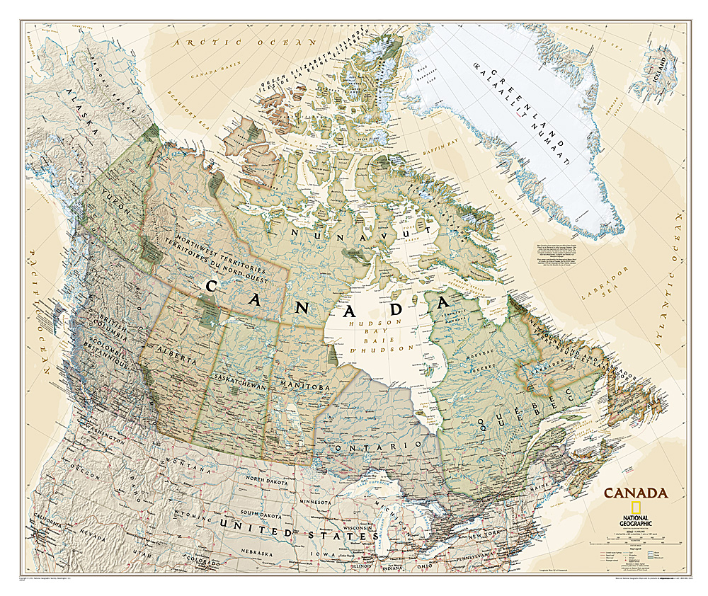
Our most detailed wall map of Canada, features the classic National Geographic reference styling. Features thousands of place names, accurate political boundaries, national parks, archeological sites, and major infrastructure networks such as roads, canals, ferry routes, and railroads. Canada’s diverse terrain is detailed through accurate shaded relief, coastal bathymetry, and symbolism for water features and other landforms. This wall map depicts Canada and the areas surrounding the Great Lakes. Includes Canadian provinces and US State boundaries.
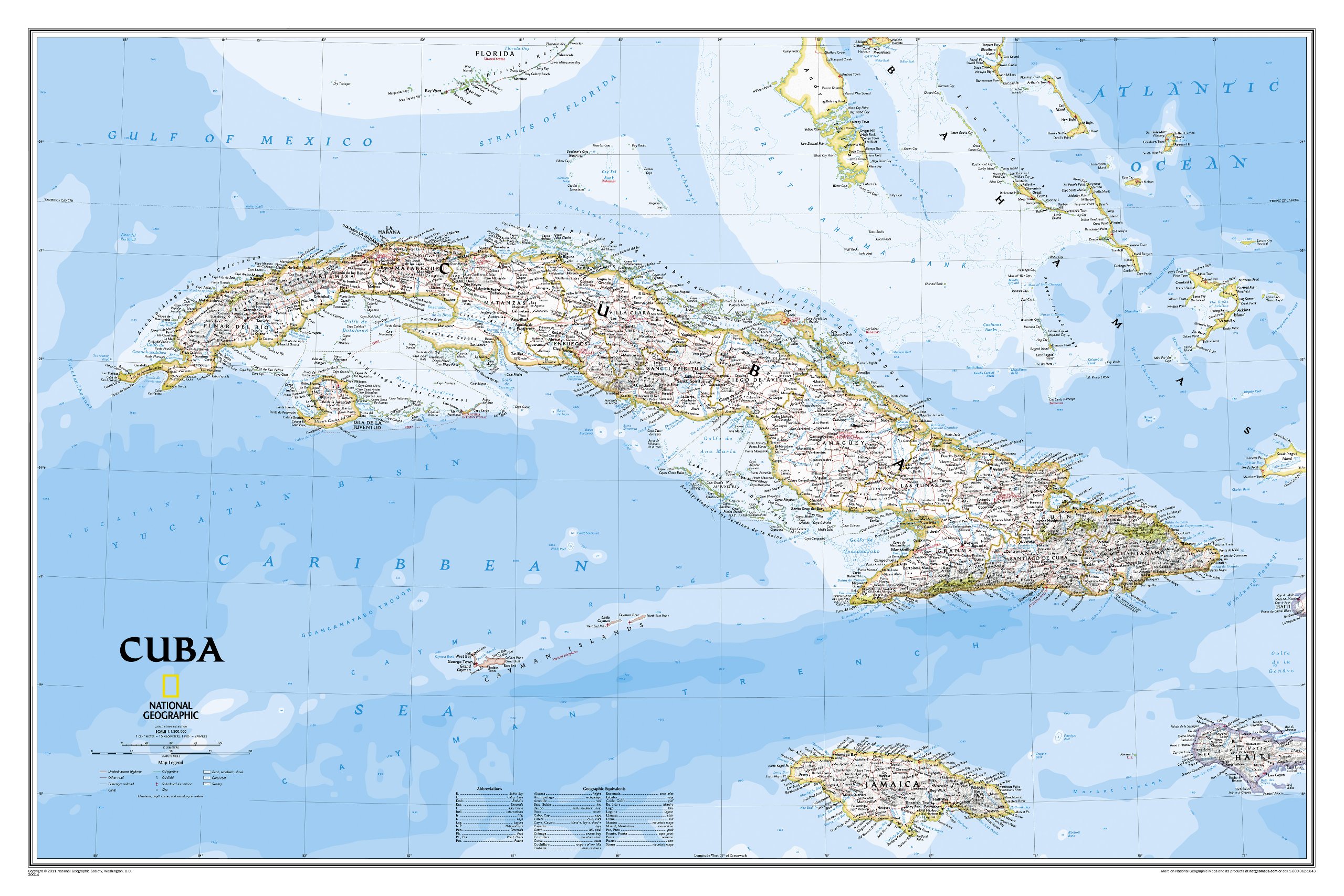
The most accurate and richly detailed reference map available for the iconic Caribbean island nation, our Cuba Classic Map contains National Geographic’s proprietary fonts and world recognized border bands in a bright and appealing color palette with striking blue oceans on a crisp white background.
Cuba’s many offshore islands, reefs, and rivers are noted, as are sites of interest. Ocean bathymetry with depth curves and soundings, peak elevations, and handcrafted shaded relief provide topographical detail. Jamaica, the Cayman Islands, the Florida Keys, and most of the Bahamas and Haiti are shown, presenting Cuba in the context of its important geographical position in the Caribbean.
Cuba contains thousand of place names, accurate political boundaries, and infrastructure making it the perfect reference for student, home, or business.
Additional content unique to this map includes:
Sites of interest including national parks and reserves
Geographic equivalents provide translations from Spanish to English
Transportation detail including highways, roads, canals, ferry routes, and airports
Geographical detail including mountain relief, swamps, and coastal reefs
Elevations, depth curves, and soundings
Coverage includes Havana, Pinar del Rio, Baracoa, Trinidad, Caya Largo, Santa Clara, Varadero, Isla de la Juventad

National Geographic is a renowned authority in cartography. For 120 years the Society's maps have helped spread geographic knowledge around the globe. A vast database allows National Geographic to combine the latest data gained by space-age technology with innovative digital mapping techniques to create state-of-the-art political, physical, and thematic maps. The Society's meticulous research and attention to detail have established a standard of achievement that is unparalleled.
The rich tones of the Political Executive map combine the popular antique look with up-to-date information—elegant enough for the board room, study, or office, and contemporary enough to make it an ideal reference.

Deze kaart wordt gemaakt in drie delen - te groot om in 1 keer te fabriceren met kans op beschadigingen - die vervolgens zeer nauwkeurig aan elkaar worden geplakt.
National Geographic is a renowned authority in cartography. For 120 years the Society's maps have helped spread geographic knowledge around the globe. A vast database allows National Geographic to combine the latest data gained by space-age technology with innovative digital mapping techniques to create state-of-the-art political, physical, and thematic maps. The Society's meticulous research and attention to detail have established a standard of achievement that is unparalleled.
The rich tones of the Political Executive map combine the popular antique look with up-to-date information—elegant enough for the board room, study, or office, and contemporary enough to make it an ideal reference.

Uitstekende wandelkaart van een deel van Kreta. De kaart is gedrukt op watervast en onverscheurbaar papier. hierdoor gaat deze veel langer mee!
De wandelkaart heeft alle noodzakelijke details voor wandelen of fietsen: naast de topografische informatie als hoogtelijnen, alle plaatsnamen (zowel Grieks als Europees schrift), het wegennet, rivieren en stroompjes, nationale parken etc is er ook veel informatie over de toeristische aspecten als stranden, kloosters, campings en afstanen tussen dorpen of steden.
Voor de wandelaars is relevant dat de E4, het bekende lange-afstandswandelpad, staat ingetekend alsmede andere wandelroutes. Sporadisch staan ook fietsroutes ingetekend.
ROAD Cartography map, was created upon intensive fieldwork and using GIS (Geographical Information Systems) software, which results all geographic information with great accuracy. Contains every single road, trails, special routes for cycling and scenic routes, villages, attractions and plenty of other useful information. This ist the most handy and reliable map that is labeld under the quality name of ROAD cartopraphy.
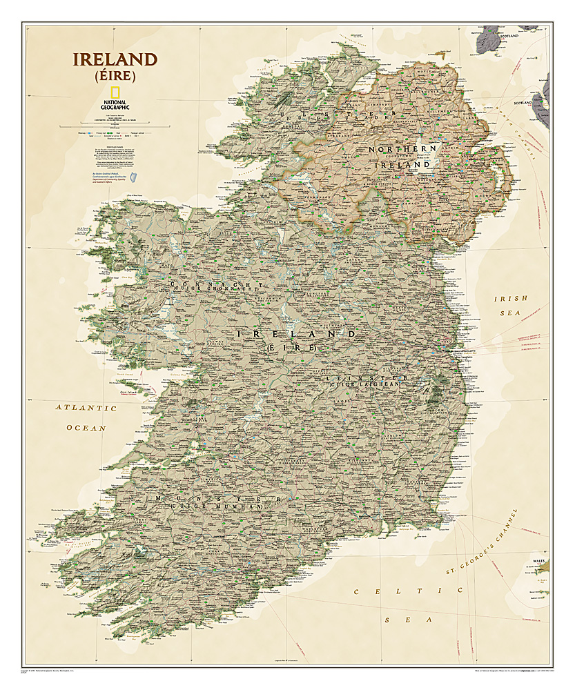
National Geographic Maps' new Ireland wall map is one of the most authoritative maps yet published of the Emerald Isle. Of the nearly 1,000 place-names shown on this map, all within the Republic of Ireland adhere to that nation's constitution—that the Irish and English language share official status. Thus, Gaelic (Irish) place-names, along with their English variants in parentheses, are shown within Irish-speaking regions while English place-names, along with their Gaelic variants, are shown outside these areas.
Ireland Classic is ideal for those researching their Irish ancestry, a perfect tool for business reference, and a beautiful addition to any décor. It’s one of the largest and most detailed wall maps specifically for Ireland available today. Shown on the map are over 1,000 named places including primary and secondary towns, counties, political boundaries, infrastructure, and selected historical sites for both Ireland and Northern Ireland.
Place-name Details:
Per the Republic of Ireland’s constitution, the Irish and English languages share official status. In the Gaeltacht, or predominantly Irish-speaking regions, only Irish place-names have official status and are used on signposts. These districts are found within the counties of Cork, Donegal, Galway, Kerry, Mayo, Meath, and Waterford.
Place-names information for the Republic of Ireland contributed by An Roinn Gnotai Pobail, Comhionannais agus Gaeltachta/ Department of Community, Equality and Gaeltacht Affairs.
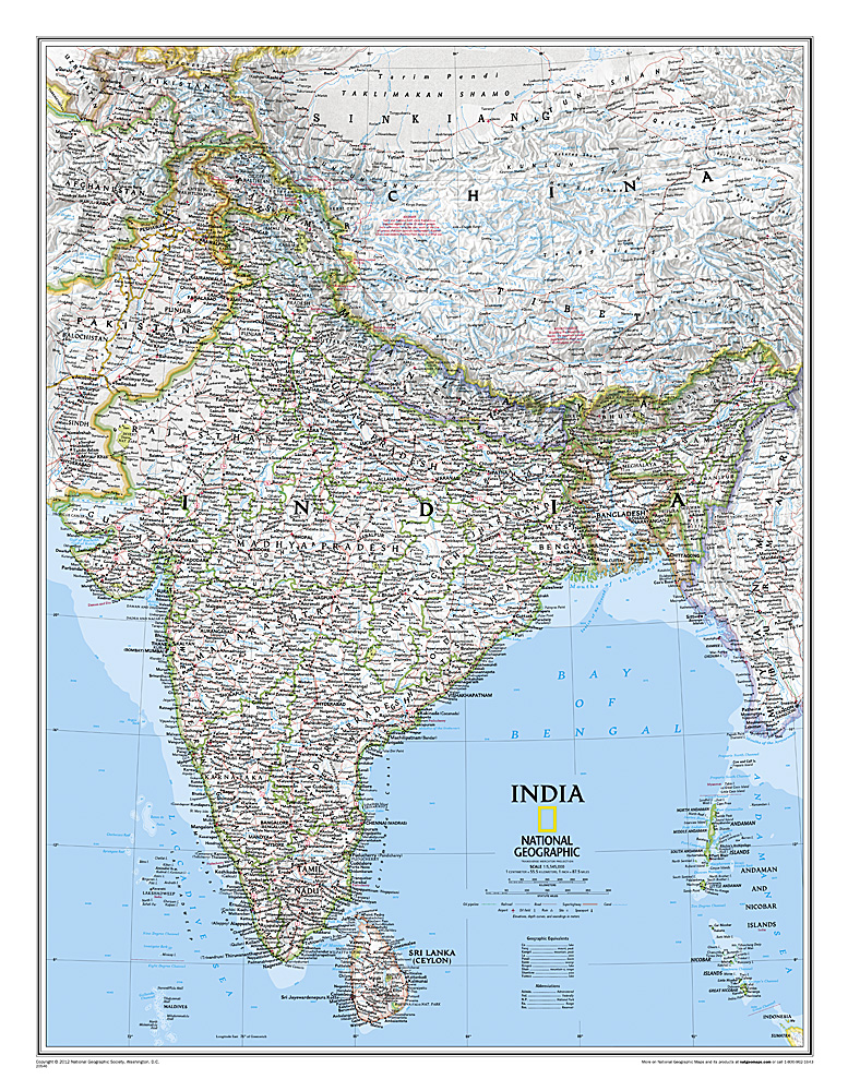
See India as only National Geographic can depict it. This new reference map is one of the most detailed and comprehensive ever published for India and southern Asia. It includes India, Sri Lanka, Nepal, Bangladesh, Bhutan, Tajikistan, and portions of China, Pakistan, Afghanistan, and Myanmar. The India map is punctuated with thousands of place names, and embellished with shaded relief which highlights the region's dramatic topography in such places as the Tibetan Plateau and the Himalaya.
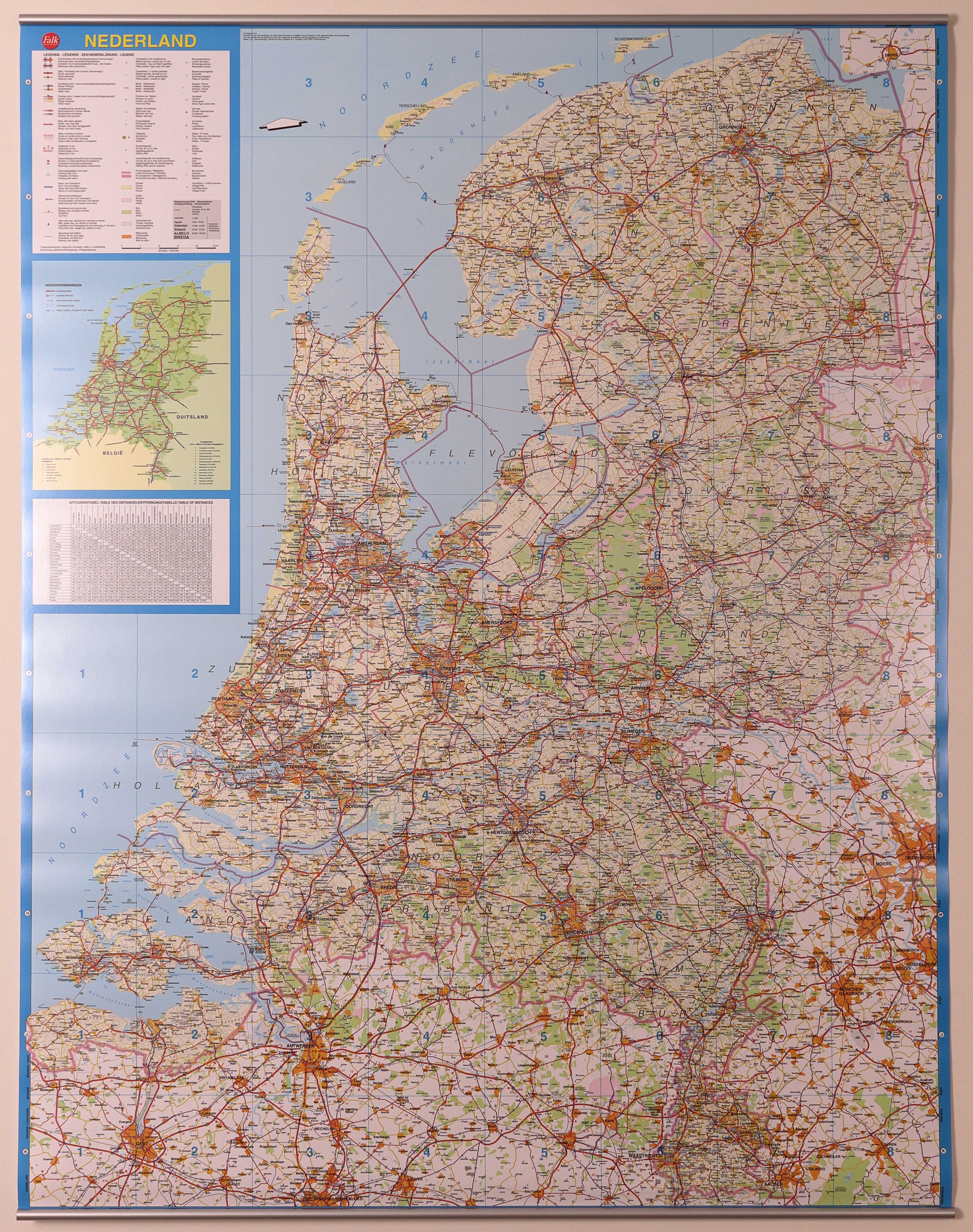
Wandkaart - Falk Nederland met een formaat van 130 (h) X 100 (b) cm. Het is een zeer gedetailleerde en duidelijke wandkaart, met veel plaatsen, wegen met wegnummers, afritten. Deze kaarten zijn echt gericht op plaatsen en wegen, natuurgebieden zijn minder duidelijk aangegeven.
Dubbelzijdig gelamineerd met metalen ophangstrips. Wordt geleverd op rol in plastic koker.

The most accurate and richly detailed reference map available for the iconic Caribbean island nation, our Cuba Classic Map contains National Geographic’s proprietary fonts and world recognized border bands in a bright and appealing color palette with striking blue oceans on a crisp white background.
Cuba’s many offshore islands, reefs, and rivers are noted, as are sites of interest. Ocean bathymetry with depth curves and soundings, peak elevations, and handcrafted shaded relief provide topographical detail. Jamaica, the Cayman Islands, the Florida Keys, and most of the Bahamas and Haiti are shown, presenting Cuba in the context of its important geographical position in the Caribbean.
Cuba contains thousand of place names, accurate political boundaries, and infrastructure making it the perfect reference for student, home, or business.
Additional content unique to this map includes:
Sites of interest including national parks and reserves
Geographic equivalents provide translations from Spanish to English
Transportation detail including highways, roads, canals, ferry routes, and airports
Geographical detail including mountain relief, swamps, and coastal reefs
Elevations, depth curves, and soundings
Coverage includes Havana, Pinar del Rio, Baracoa, Trinidad, Caya Largo, Santa Clara, Varadero, Isla de la Juventad
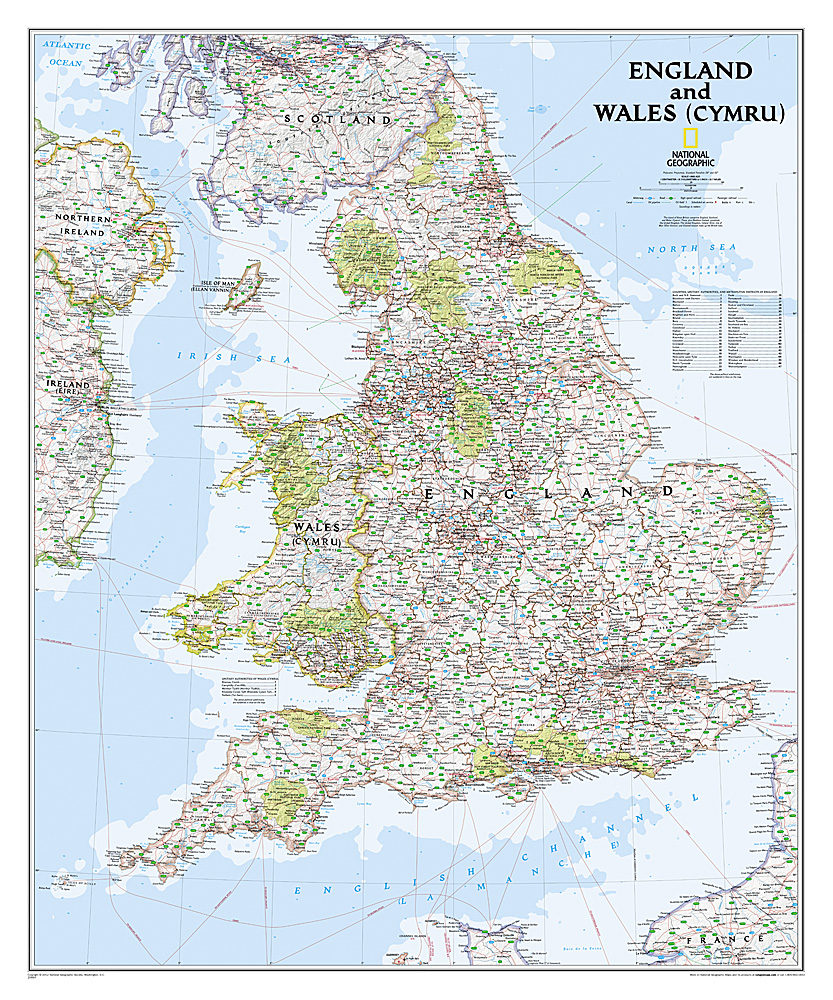
This classic-style map of England and Wales shows political boundaries, major highways and roads, cities and towns, airports, and other geographic details. Thousands of place-names and exact borders are carefully researched by National Geographic’s map researchers and editors ensuring the utmost accuracy.
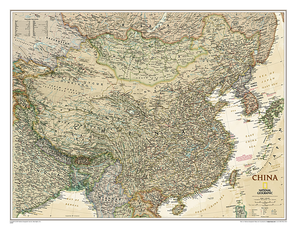
This detailed political map of China accurately shows locations of provincial boundaries, cities and towns, major highways and roads, rivers and waterways, and other geographic features.
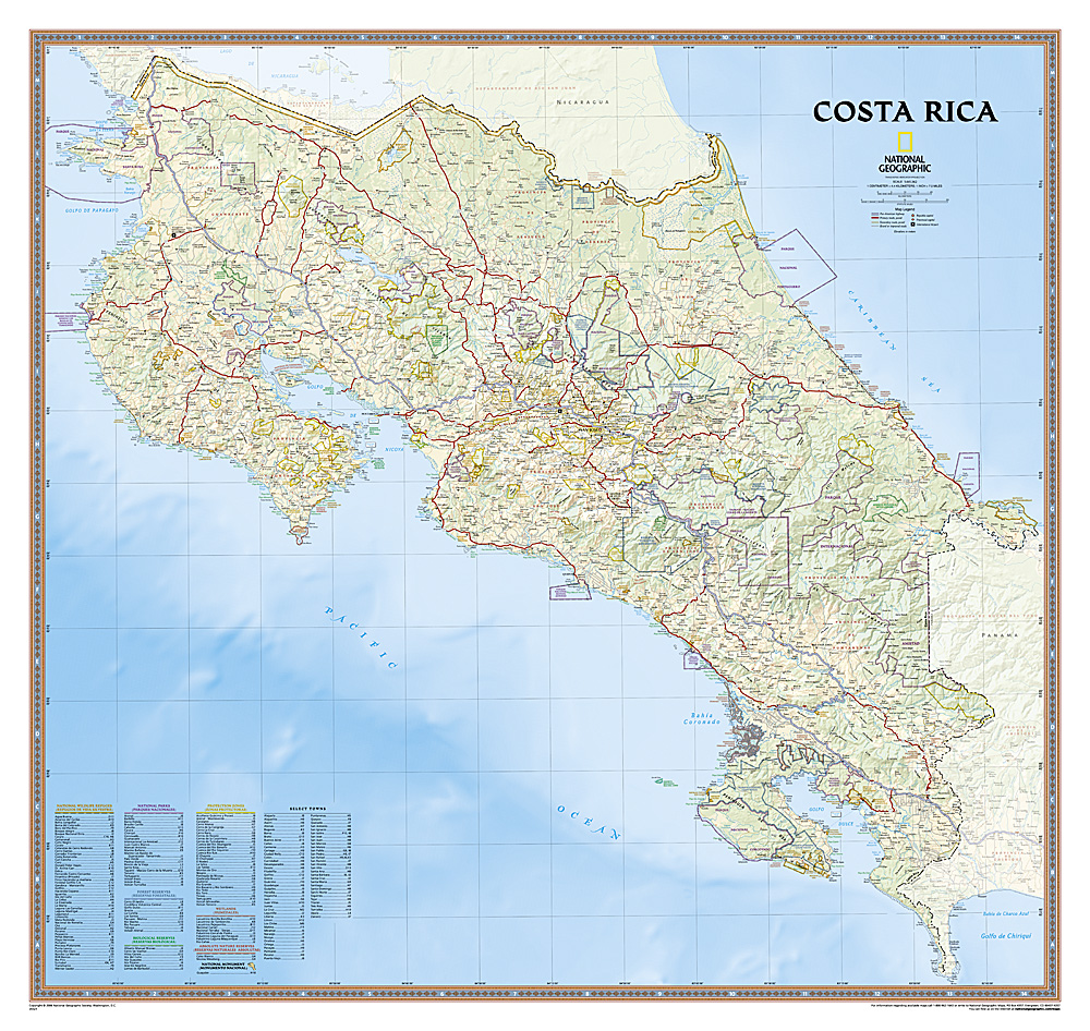
Decoratieve wandkaart van Costa Rica. Naast de mooie kleuren staan er bijzonder veel plaatsen op vermeld.
This full-color map is a richly detailed rendering of one of Central America's greatest treasures. From its northern savannahs and plains to lush forests and pristine jungle-lined beaches, Costa Rica's beauty and diversity beckon! The map also includes outlines and information for National Parks, Protection Zones, and more.

This classic-style map of England and Wales shows political boundaries, major highways and roads, cities and towns, airports, and other geographic details. Thousands of place-names and exact borders are carefully researched by National Geographic’s map researchers and editors ensuring the utmost accuracy.